Showing 16203 items
matching '' place
-
 Port Fairy Historical Society Museum and Archives
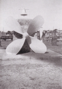
Photograph, 1930's
This Memorial was set up in memory of the nine people who drowned when the S.S.Casino sank in Apollo Bay in 1932.The cement plinth carries a bronze plaque with the names of the nine people who drowned on one side, the propeller, the wreck bell used to alert the lifeboat crew that there was an incident in the bay and for many years a large barometer that was consulted by the local fishermen before setting out to sea. A memorial Service is held each year on July the 10th at 11 am the time that the sinking took place. The Casino was about to celebrate her 50th year of plying the southwest trade route. Black and white photograph of Propeller from SS Casino as memorial memorial, s.s.casino, propeller, barometer, moyne river, sea -
 Vision Australia
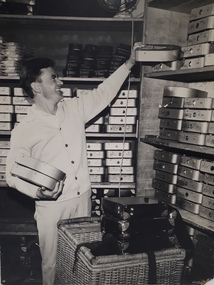
Photograph - Image, Man collecting Clarke & Smith cartridges from shelves
Male handles Clarke & Smith talking book cartridges, placing one cartridge on a bookcase filled with numbered cartridges, whilst holding another two in his other hand. To the side of him is a cane basket that contains black mailing cases with silver reinforced corners and strapping. These cases were used to send the cartridges out to talking book clients. Behind the man is another bookshelf, with the two bottom shelves containing mailing cases, the next two Clarke & Smith cartridges and possibly Clarke & Smith tapetes and tapete mailing pouches on the top shelf. A metal fan hits on top of the bookcase.Digital image of man with audio book cartridgestalking books, library, royal victorian institute for the blind -
 Wodonga & District Historical Society Inc
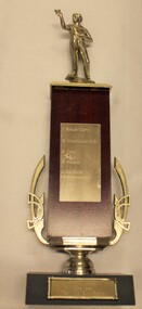
Award - Wodonga Darts Association Premiers 1985
The Terminus Hotel was one of the earliest hotels in Wodonga, with clear links to the establishment of the railway line. It was an important business and meeting place from the original construction in 1873 until 1st June 1998 the Terminus Hotel when it was destroyed by fire. It provided a popular venue for social activities, including competitive darts, both through its own competition and as part of the Albury-Wodonga District Darts Association. The remains of the building were demolished in 1999. This is perpetual trophy for the Terminus Dart club based at the Terminus Hotel in Wodonga. This trophy recognises the winners of the Albury-Wodonga Darts Association Premiers 1985.The Terminus Hotel was an important meeting place in Wodonga for more than 100 years. This item is representative of one of the social and sporting activities it provided for members of the local community.A trophy made from timber and metal with a representation of a darts player on the top.At base: "A.W.D.D.A 1985/ PREMIERS TERMINUS EASY BEATS Listed on front: I. BOSLEY (CAPT.) G. MULHOLLAND (V.C.) K. COOK R. HUDSON J. DE KRUIFF D. ROWE B. SAYERSterminus hotel wodonga, albury-wodonga district darts association, sport and recreation -
 Darebin Art Collection
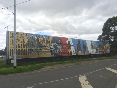
Artwork, other - Megan Evans, Millie Yarran, Ian Johnson, Les Griggs, Elaine Trott and Ray Thomas, Megan Evans, Millie Yarran, Ian Johnson, Les Griggs, Elaine Trott and Ray Thomas, Koori Mural, 1983
The Koori Mural was designed by artist Megan Evans in consultation with a committee from the Aborigines Advancement League consisting of the late Lin Onus, the late Molly Dyer, the late Ron Johnson and the late Elizabeth Hoffman. It was painted by Evans and renowned Aboriginal artist Ray Thomas along with Ian Johnson, Millie Yarram, Les Griggs, Elaine Trott and a number of volunteers. The mural has considerable historical and cultural significance and refers to the experiences of the the Aboriginal and Torres Strait Islander communities, from early colonial history to the more recent struggle for social justice. In 2014 the mural was replicated onto a vinyl banner and installed at its current site. The Northcote Koori Mural was originally located on Council land in High Street, Northcote, opposite the Northcote Town Hall. A huge, free-standing wall was built specifically to accommodate the mural which was painted on site. The land on which the mural was housed was later sold, however, and the mural was relocated to the Aborigines Advancement League in St. Georges Road, Thornbury. Conservation work in 2014 and original panels decommissioned and vinyl banner hung in its place (with Total Outdoor Media). In 2015 solar lights were installed along with landscaping to the front of the mural and a plaque depicting the history on the mural. -
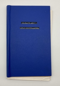 Melbourne Legacy
Book - Book, diary, The Blackwood Papers, 1976
The diary written by Legatee George Blackwood which gives an account of the life of a Melbourne Legacy President in 1975, the people he meets, the places he goes and some humour. The forward was written by Legatee Ravenscroft who was president in 1983. The first few pages deal with the history of Legacy. Then there are the speeches that were spoken at the handover dinner when Legatee Blackwood was the outgoing president and Legatee Baker was incoming. The speeches had interesting facts and insights into the characters of some of the legatees. Subsequent pages included the day to day events that the President experienced under the title of President's Musings and Meanderings.There is much valuable information in this diary for all to read. As such the diary was passed on to succeeding presidents as a guide.Blue cardboard cover with white paper pages.On the first page there is a note to the diary and the signature of Legatee Len E. Ravenscroft, Melbourne Legacy President 1983.past presidents, len ravenscroft, speeches, george blackwood, history -
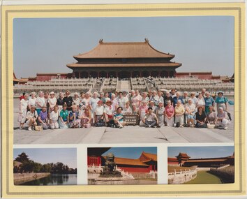 Melbourne Legacy
Photograph - Widows outing, China Beijing Swan Promotion Co Ltd, China Tour 1993, 1993
Colour photo of a group of Legacy widows in Beijing China. Melbourne Legacy would help arrange tours and day trips for the Widows clubs. This was a tour in 1993 that went to China. There appears to be about 50 ladies in the photo with a two tour guides. From the sign it appears it was taken on 23 June 1993. The tour was run by Interasia Tours and advertised in The Answer. It was an 8 day tour to Beijing and covered places such as Temple of Heaven, Tiananmin Square, Forbidden City, Summer Palace, Ming Tombs and the Great Wall of China. It was fully inclusive and only $1,449 per person twin share.A record of outings and activities being provided for the widows.Colour photo of widows in Beijing China in 1993, in a souvenir folder.Cardboard folder is labelled 'China Beijing Swan Promotion Co Ltd.' Photo includes a sign saying 'The Palace Museum Tai He Dian Hall 1993/6/23'.widows, souvenir, beijing, answer -
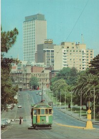 Melbourne Tram Museum
Postcard - National View, Nucolorvue Publishing, Wellington Parade Melbourne, early 1970's
One of a series of postcards published by National View by Murfett Publishers Australia. Has the details on the rear with place for a stamp, address etc, and logo. Shows W2 546 (Spencer St Route 38), possibly about to pick up passengers at the Jolimont Road Stop. At the time Wellington Parade was effectively a one-way street with extensive car parking on the south side. Shows a Safety Zone on the north side of the tram tracks. Has the CRA building, the hotel on the corner of Flinders and Spring St that was demolished for Shell House. See Reg Item 3555 for a later view by the same company.Yields information about the appearance of Wellington Parade, Jolimont, mid to late 1970's.Postcard - National View - plain edges, Wellington Parade looking west towards the CBD. Card No. P-1014-2w2 class, postcard, souvenir, wellington parade, route 38, tram 546, national view -
 Melbourne Tram Museum
Document - Notice, Melbourne & Metropolitan Tramways Board (MMTB), "Trolley Poles and Trolley Ropes", 1963
Set of five circulars about Trolley Poles and their use on trams: 1 - Emergency Trolley Rope - fitting to trams - foolscap dated 25/10/1963 2 - trolley poles and climbing onto the roof - quarto dated 17/12/1963 3 - Procedure for placing front trolley pole in trailing position - foolscap - 20/12/1963 4 - Trolley pole rope guide clip - two foolscap sheets with space for an photo - 11/11/1964 5 - Trolley pole rope guide clip - quarto sheet dated 12/11/1964.Yields information about the use of trolley poles on Melbourne trams.Document - Set of five foolscap or quarto sheets, duplicated, each with two punched holes on left side.tramways, instructions, trolley poles, operations, safety -
 Sunbury Family History and Heritage Society Inc.
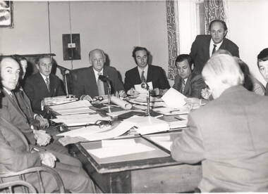
Photograph, Sunbury Regional Newspapers, Shire of Bulla, 15th July 1974
The men in the photograph are former councillors and they are at an ordinary meeting of the Shire of Bulla council, which took place on 15th July 1974 at the Old Shire Offices in Bulla. Council usually met at the Council Offices in Sunbury but there were times when they met at the Old Shire Offices in Bulla. The people are from L-R: M.Donovan, J.Watson (Deputy Shire Secretary), John Kelly (Shire secretary), C.E.Cook, J.P. (Shire President), John McKerrow ( Shire engineer), D.W.Dumbrell, A.V.Mitchell (Deputy Shire Engineer - Standing), J. Kelly, Eric Boardman (Regional News Gazette - Back to Camera) A non-digital black and white photograph with a cream border, of ten men seated around a table conducting a meeting in a room.Information about the event is filed with the photograph in the pocket.shire of bulla, old shire offices, bulla, councillors, council meetings -
 Warrnambool and District Historical Society Inc.
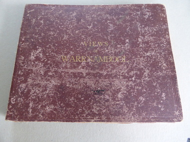
Album, Photographs Views of Warrnambool, c 1891
This album contains photographs of many Warrnambool buildings and scenes, including Proudfoot Boatsheds, St. John’s Church, Christ Church, Shelly Beach, Hopkins Falls, Sherwood gardens and buildings, Ozone Coffee Palace, Kepler Street, Sandstone Quarries and the Titan Crane on the Breakwater. The photographs have been taken and put in album form by the photographer Joseph Jordan. The advertisements of the hotels on the inside covers place the publication of the album to the years1891-2. We have another album similar to this but there are six photographs in this album (VC000799) that are not in the other album. These extra photographs are of the original gardens and buildings of Sherwood.This is a most important album as the photographs are clear and show a good cross-section of Warrnambool in the early 1890s. Some of the photographs are not represented in other collections (eg Sherwood gardens) and so are of vital historical significance. The advertisements are also of great use to researchers.This album has a brown hard cover and contains three pages of local advertisements and sixteen pages of photographs and 32 photographs back to back. The pages have been bound but some pages have come loose. There is a fold-out section of a 180 degree panorama of Warrnambool taken from Liebig Street hill. The edges of these pages have been taped.Front Cover- Views of Warrnamboolwarrnambool, views of warrnambool, photos of warrnambool -
 Eltham District Historical Society Inc
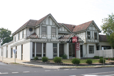
Photograph - Digital Photograph, Alan King, Eltham Hotel, cnr Main Road and Pitt Street, 28 December 2007
The Eltham Hotel is the oldest continually operating hotel in the Eltham district. Initially referred to as the Little Eltham Hotel, it has been known as the Eltham Hotel since the mid-1850s through to the present except for a brief period as the Eltham Tavern in the late 1980s. The original hotel opened in 1854 by Richard Warren was built by Benjamin Oliver Wallis. The Fountain of Friendship Hotel on the opposite side of Maria Street (Main Road) opened shortly after. The hotel was a well-known resting place for gold diggers during the gold rush at Woods’ Point and Warren would buy the gold from the diggers. Warren ran into financial difficulties and determined to return to England. Wallis bought the hotel in 1861 and ran it till 1886 when he sold it to Christopher Watson Snr. When Christopher Watson Snr died a year after purchase, his son Christopher took over until his death in 1909 when it passed to wife Emily and then their youngest son, Herbert James (Jim) Watson in 1915. In July 1925, Jim Watson demolished the original building and, in its place, erected a modern hotel which remains the foundation of the present-day Eltham Hotel. Covered under Heritage Overlay, Nillumbik Planning Scheme. Published: Nillumbik Now and Then / Marguerite Marshall 2008; photographs Alan King with Marguerite Marshall.; p41This collection of almost 130 photos about places and people within the Shire of Nillumbik, an urban and rural municipality in Melbourne's north, contributes to an understanding of the history of the Shire. Published in 2008 immediately prior to the Black Saturday bushfires of February 7, 2009, it documents sites that were impacted, and in some cases destroyed by the fires. It includes photographs taken especially for the publication, creating a unique time capsule representing the Shire in the early 21st century. It remains the most recent comprehenesive publication devoted to the Shire's history connecting local residents to the past. nillumbik now and then (marshall-king) collection, eltham, eltham hotel, main road, pitt street -
 Flagstaff Hill Maritime Museum and Village
Tool - Bullet Mould, From 1600s to early 19th century
Musket balls are the ammunition used in muskets the weapons used during the English and American Civil Wars. The balls could be made from any metal alloy, but many were made from lead. Lead can be melted at reasonably low temperatures and so lead musket balls could be made over a camp fire. Lead could be readily sourced from such places like church roofs or even coffins, and recast from old musket balls, so it was an easy material to work with while preparing for battle. The soldier would carry a crucible in which to melt the lead, he would put the material into it and place it over the fire until it had formed into a liquid. Musket ball moulds like the subject item, had a small hole above one of the domes where the liquid could be poured into once the two domes were closed together. The soldier would wait until it cooled then opened the mould to reveal a solid lead ball inside. Because these were cast in halves even though pressed together, there would always be a small amount of liquid lead leakage which would form a thin crust around the ball. These needed to be filed off before being used inside a musket, so some soldiers would pop a few in their mouths and roll them around, chewing off the excess until the ball was smooth. The obvious downside to this method is that lead is poisonous. A tool used to make ammunition for black powder firearms either muskets or pistols from the early part of the 18th to mid 19th century. After this time enclosed brass cartridges that held the propellent powder and bullet were starting to come into wide spread use, negating the need for a firearm to first have black powder placed in a barrel then the ball rammed on top and finally the firearm primed with powder or a percussion cap.Musket rifle/ pistol bullet mold. Makes .50 -caliber- round balls with a sprew cutter to cut off excess lead.Marked 50flagstaff hill, warrnambool, shipwrecked coast, flagstaff hill maritime museum, maritime museum, shipwreck coast, flagstaff hill maritime village, great ocean road, shot pliers, lead shot, shot, armoury, firearms, bullet, cast bullet, lead ball, lead shot, scissor mould -
 Flagstaff Hill Maritime Museum and Village
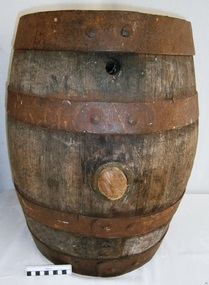
Container - Barrel, 19th century
This small barrel looks well used. Unfortunately, the inscription on the barrel is indecipherable so its story is a mystery. However, the bungholes on the side are a clue that it was once used for storing liquid, likely to have been liquor. Barrels have been used over many centuries for transporting and storing a wide range of dry and liquid goods. They are made by tradesmen called coopers, who use heat and steam to bend and shape the wood to suit the work in hand. They add metal reinforcing, handles, spouts and suchlike, to complete they process. Their produce also includes buckets, casks and tubs. Ships transported bulk liquor in their cargo, stored in wooden barrels. The barrels' round shape allowed them to be easily moved by rolling them into place. The body's shape gave the barrels added strength and the iron bands helped the wooden sheaves stay in place. The tops and bottoms allowed for easy grip. The bungholes gave access to government representatives, who would sample the contents, measure the alcohol percentage, and charge the appropriate duty or tax; the process was called Ullaging and the instrument they used was a Hydrometer. Hundreds of barrels of cement were imported into Warrnambool in the late 19th century for the construction of the Warrnambool Breakwater. Barrel-shaped concrete blocks are still visible at shipwreck sites such as on the LOCH ARD wreck, which carried cement among its cargo.This small barrel is representative of 19th century containers used for transportation and storage of liquid such as liquor. It is a historic shape that is still used in modern times.Barrel; wooden barrel, cylindrical shape with metal bands or ribs for reinforcement. The side has two bungholes; one has a bung or stopper. Inscription on top (indecipherable). (indecipherable)flagstaff hill, warrnambool, shipwrecked-coast, flagstaff-hill, flagstaff-hill-maritime-museum, maritime-museum, shipwreck-coast, flagstaff-hill-maritime-village, barrel, cask, small barrel, trade, coopering, cooper, casket, transport, storage, bunghole -
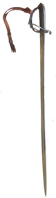 Federation University Historical Collection
Weapon - Object, Sword, 1877
In 1862, the units of the Mounted Volunteer Corps in Victoria were formed into a single regiment known as the Victorian Volunteer Light Horse. This title changed again in 1863, to the Prince of Wales Victorian Volunteer Light Horse ( Hussars ). In 1870 a uniform was adopted that was based on the British 19th Hussars. Troops were based at various times at Geelong, Ballarat, Kyneton, Bendigo, Castlemaine and Dandenong, as well as metropolitan Melbourne. In 1885, most of the Cavalry were incorporated into a newly formed Victorian Mounted Rifles. (http://www.awm.gov.au/collection/REL/18070.001) "It is notified in the Gazette that Lieutenant Laurence Whyte, Ballarat troop Prince of Wales Light Horse, has been appointed captain, seniority to date from January 31. " (The Argus, 17 February 1883) "An official inspection of the P.W.L.H. took place in the Royal Park last evening by the colonel-commandant, assisted by Colonel Rede; Captain Medealf in command of the, troop. After bring exercised in field movements, a sword competition took place, toe first prize bring awarded to Trooper L. Whyte ; the "second to Sergeant Blight; the third, to Trooper Jenkins; and the fourth, to Trooper Orr, of Creswick. Major Sleep officiated as timekeeper. The colonel commandant complimented Captain Med-calf upon the efficiency of the troop, and officers and men afterwards dined together at Craig's hotel. (Ballarat Courier, 09 March 1877.)Silver coloured sword and scabbard with leather hand grip within the hilt. The sword was awarded to Trooper Whyte of the Prince of Wales Victorian Volunteer Light Horse (Ballarat) in 1877.. Engraved into handle "Ballarat Troop P.W.V.V.L.H Officers Trophy FIRST PRIZE WON BY Trooper Whyte AT SWORD Competition 8th March 1877" volunteer forces, sword, trooper whyte, prince of wales victorian volunteer light horse (ballarat), l. whyte, laurence whyte -
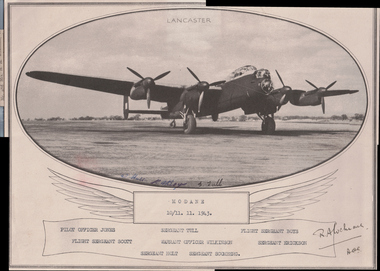 Wangaratta RSL Sub Branch
Print, 1943
During World War II, the city of Modane in the southeast region of France was bombed on 13 or 17 September 1943 by Allied aircraft. The objective of the bombing was the station, an important centre of transit between France and Italy. The bombing caused 60 victims and 100 houses were destroyed. A second bombing took place on the night of 10–11 November 1943. Crew of "M" for Mother, a Lancaster aircraft belonging to No. 467 Squadron RAAF in Bomber Command.included: - 417035 Flight Sergeant (Flt Sgt, later Flying Officer [FO]) John Warrington Scott of Ballarat, Victoria; 413558 Flt Sgt (later FO) George Edward Erickson of Sydney, NSW; 412890 Flt Sgt (later Flight Lieutenant [Flt Lt]) Albert Reginald Thomas Boys of Sydney, NSW; 414407 Flt Sgt (later Flt Lt) Bertram Raymond Jones of Wyandra, Queensland; 400444 Flt Sgt (later Flt Lt) John Hudson Wilkinson, (later Distinguished Flying Cross) of Rutherglen, Victoria (lost on operations over Europe on 30 August 1944); Sgt E L Tull, RAF. From collection of photographs and cuttings dedicated to the memory of WILKINSON JOHN HUDSON : Service Number - 400444 : Date of birth - 18 Feb 1914 : Place of birth - RUTHERGLEN VIC Wilkinson was awarded the distinguished flying cross in March 1944. The significance of this item records the names of the Lancaster aircraft flight crew which took part in the second allied bombing of Modane a small city in the south eastern region of France which was an important centre of transit between France and Italy during the second world war. The bombing took place on the 10-11 November 1943 killing five civilians.oval shaped copy of black and white photograph of a Lancaster plane above scroll containing names of servicemen.Modane 10/11.11.1943 Signatures of Sergeant Holt, Sergeant Tull and Flight Sergeant Boysdistinguished flying cross, world war two, air force, modane, france, pilot officer john hudson wilkinson -
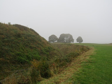
 Ballarat Heritage Services
Photograph - Colour, Earth Banks, Old Sarum, England, 2016, 01 November 2016
William the Conqueror inherited Old Sarum from the last Saxon king of England. It was an ideal site for a royal castle. It was here in 1070 that William paid off his army after a long and bitter campaign in northern England. It was here in 1086 that he called together all the major landholders in England so they could swear allegiance to him. It was a crucial moment. The Domesday Book was being written, a threatened Viking invasion had only just been averted and William's eldest son was in armed rebellion. Old Sarum was an important place where this Norman king of England held power. In 1794 the Ordnance Survey set out to check the accuracy of the first mapping of Southern England, which had begun ten years earlier. From a point just below Old Sarum Lieutenant William Mudge laid out a base-line 36,574 feet (11,253 metres) long. From each end of the line the positions of distant places were plotted using a huge theodolite made in 1791 by Jesse Ramsden. The accuracy of the process, which was repeated all over England, depended on Jesse Ramsden's craftsmanship and on William Mudge's surveying skill in setting out this first base-line from Old Sarum. The nearer end of Mudge's line is marked by an inscribed stone beside the modern A345 at Old Sarum. ordnance survey, william mudge, jesse ramsden, william the conqueror, old sarum, saxon, 1086, england -
 Ballarat Heritage Services
Photograph - Colour, Earth Banks, Old Sarum, England, 01 November 2016
William the Conqueror inherited Old Sarum from the last Saxon king of England. It was an ideal site for a royal castle. It was here in 1070 that William paid off his army after a long and bitter campaign in northern England. It was here in 1086 that he called together all the major landholders in England so they could swear allegiance to him. It was a crucial moment. The Domesday Book was being written, a threatened Viking invasion had only just been averted and William's eldest son was in armed rebellion. Old Sarum was an important place where this Norman king of England held power. In 1794 the Ordnance Survey set out to check the accuracy of the first mapping of Southern England, which had begun ten years earlier. From a point just below Old Sarum Lieutenant William Mudge laid out a base-line 36,574 feet (11,253 metres) long. From each end of the line the positions of distant places were plotted using a huge theodolite made in 1791 by Jesse Ramsden. The accuracy of the process, which was repeated all over England, depended on Jesse Ramsden's craftsmanship and on William Mudge's surveying skill in setting out this first base-line from Old Sarum. The nearer end of Mudge's line is marked by an inscribed stone beside the modern A345 at Old Sarum. ordnance survey, william mudge, jesse ramsden, william the conqueror, old sarum, saxon, 1086, england -
 Ballarat Heritage Services
Photograph - Colour, Earth Banks, Old Sarum, England, 2016, 01 November 2016
William the Conqueror inherited Old Sarum from the last Saxon king of England. It was an ideal site for a royal castle. It was here in 1070 that William paid off his army after a long and bitter campaign in northern England. It was here in 1086 that he called together all the major landholders in England so they could swear allegiance to him. It was a crucial moment. The Domesday Book was being written, a threatened Viking invasion had only just been averted and William's eldest son was in armed rebellion. Old Sarum was an important place where this Norman king of England held power. In 1794 the Ordnance Survey set out to check the accuracy of the first mapping of Southern England, which had begun ten years earlier. From a point just below Old Sarum Lieutenant William Mudge laid out a base-line 36,574 feet (11,253 metres) long. From each end of the line the positions of distant places were plotted using a huge theodolite made in 1791 by Jesse Ramsden. The accuracy of the process, which was repeated all over England, depended on Jesse Ramsden's craftsmanship and on William Mudge's surveying skill in setting out this first base-line from Old Sarum. The nearer end of Mudge's line is marked by an inscribed stone beside the modern A345 at Old Sarum. ordnance survey, william mudge, jesse ramsden, william the conqueror, old sarum, saxon, 1086, england -
 Ballarat Heritage Services
Photograph - Colour, Earth Banks, Old Sarum, England, 01 November 2016
William the Conqueror inherited Old Sarum from the last Saxon king of England. It was an ideal site for a royal castle. It was here in 1070 that William paid off his army after a long and bitter campaign in northern England. It was here in 1086 that he called together all the major landholders in England so they could swear allegiance to him. It was a crucial moment. The Domesday Book was being written, a threatened Viking invasion had only just been averted and William's eldest son was in armed rebellion. Old Sarum was an important place where this Norman king of England held power. In 1794 the Ordnance Survey set out to check the accuracy of the first mapping of Southern England, which had begun ten years earlier. From a point just below Old Sarum Lieutenant William Mudge laid out a base-line 36,574 feet (11,253 metres) long. From each end of the line the positions of distant places were plotted using a huge theodolite made in 1791 by Jesse Ramsden. The accuracy of the process, which was repeated all over England, depended on Jesse Ramsden's craftsmanship and on William Mudge's surveying skill in setting out this first base-line from Old Sarum. The nearer end of Mudge's line is marked by an inscribed stone beside the modern A345 at Old Sarum. ordnance survey, william mudge, jesse ramsden, william the conqueror, old sarum, saxon, 1086, england -
 Ballarat Heritage Services
Photograph - Colour, Stonework, Old Sarum, England, English Heritage Site, 01 November 2016
William the Conqueror inherited Old Sarum from the last Saxon king of England. It was an ideal site for a royal castle. It was here in 1070 that William paid off his army after a long and bitter campaign in northern England. It was here in 1086 that he called together all the major landholders in England so they could swear allegiance to him. It was a crucial moment. The Domesday Book was being written, a threatened Viking invasion had only just been averted and William's eldest son was in armed rebellion. Old Sarum was an important place where this Norman king of England held power. In 1794 the Ordnance Survey set out to check the accuracy of the first mapping of Southern England, which had begun ten years earlier. From a point just below Old Sarum Lieutenant William Mudge laid out a base-line 36,574 feet (11,253 metres) long. From each end of the line the positions of distant places were plotted using a huge theodolite made in 1791 by Jesse Ramsden. The accuracy of the process, which was repeated all over England, depended on Jesse Ramsden's craftsmanship and on William Mudge's surveying skill in setting out this first base-line from Old Sarum. The nearer end of Mudge's line is marked by an inscribed stone beside the modern A345 at Old Sarum. ordnance survey, william mudge, jesse ramsden, william the conqueror, old sarum, saxon, 1086, england -
 Ballarat Heritage Services
Photograph - Colour, Stonework, Old Sarum, England, English Heritage Site, 2016, 01 November 2016
William the Conqueror inherited Old Sarum from the last Saxon king of England. It was an ideal site for a royal castle. It was here in 1070 that William paid off his army after a long and bitter campaign in northern England. It was here in 1086 that he called together all the major landholders in England so they could swear allegiance to him. It was a crucial moment. The Domesday Book was being written, a threatened Viking invasion had only just been averted and William's eldest son was in armed rebellion. Old Sarum was an important place where this Norman king of England held power. In 1794 the Ordnance Survey set out to check the accuracy of the first mapping of Southern England, which had begun ten years earlier. From a point just below Old Sarum Lieutenant William Mudge laid out a base-line 36,574 feet (11,253 metres) long. From each end of the line the positions of distant places were plotted using a huge theodolite made in 1791 by Jesse Ramsden. The accuracy of the process, which was repeated all over England, depended on Jesse Ramsden's craftsmanship and on William Mudge's surveying skill in setting out this first base-line from Old Sarum. The nearer end of Mudge's line is marked by an inscribed stone beside the modern A345 at Old Sarum. ordnance survey, william mudge, jesse ramsden, william the conqueror, old sarum, saxon, 1086, england -
 Ballarat Heritage Services
Photograph - Colour, Stonework and well, Old Sarum, England, English Heritage Site, 2016, 01 November 2016
William the Conqueror inherited Old Sarum from the last Saxon king of England. It was an ideal site for a royal castle. It was here in 1070 that William paid off his army after a long and bitter campaign in northern England. It was here in 1086 that he called together all the major landholders in England so they could swear allegiance to him. It was a crucial moment. The Domesday Book was being written, a threatened Viking invasion had only just been averted and William's eldest son was in armed rebellion. Old Sarum was an important place where this Norman king of England held power. In 1794 the Ordnance Survey set out to check the accuracy of the first mapping of Southern England, which had begun ten years earlier. From a point just below Old Sarum Lieutenant William Mudge laid out a base-line 36,574 feet (11,253 metres) long. From each end of the line the positions of distant places were plotted using a huge theodolite made in 1791 by Jesse Ramsden. The accuracy of the process, which was repeated all over England, depended on Jesse Ramsden's craftsmanship and on William Mudge's surveying skill in setting out this first base-line from Old Sarum. The nearer end of Mudge's line is marked by an inscribed stone beside the modern A345 at Old Sarum. ordnance survey, william mudge, jesse ramsden, william the conqueror, old sarum, saxon, 1086, england -
 Ballarat Heritage Services
Photograph - Colour, Stonework, Old Sarum, England, English Heritage Site, 01 November 2016
William the Conqueror inherited Old Sarum from the last Saxon king of England. It was an ideal site for a royal castle. It was here in 1070 that William paid off his army after a long and bitter campaign in northern England. It was here in 1086 that he called together all the major landholders in England so they could swear allegiance to him. It was a crucial moment. The Domesday Book was being written, a threatened Viking invasion had only just been averted and William's eldest son was in armed rebellion. Old Sarum was an important place where this Norman king of England held power. In 1794 the Ordnance Survey set out to check the accuracy of the first mapping of Southern England, which had begun ten years earlier. From a point just below Old Sarum Lieutenant William Mudge laid out a base-line 36,574 feet (11,253 metres) long. From each end of the line the positions of distant places were plotted using a huge theodolite made in 1791 by Jesse Ramsden. The accuracy of the process, which was repeated all over England, depended on Jesse Ramsden's craftsmanship and on William Mudge's surveying skill in setting out this first base-line from Old Sarum. The nearer end of Mudge's line is marked by an inscribed stone beside the modern A345 at Old Sarum. ordnance survey, william mudge, jesse ramsden, william the conqueror, old sarum, saxon, 1086, england -
 Ballarat Heritage Services
Photograph - Colour, Sign Explaining toilets, Old Sarum, England, English Heritage Site, 01/11/2016
William the Conqueror inherited Old Sarum from the last Saxon king of England. It was an ideal site for a royal castle. It was here in 1070 that William paid off his army after a long and bitter campaign in northern England. It was here in 1086 that he called together all the major landholders in England so they could swear allegiance to him. It was a crucial moment. The Domesday Book was being written, a threatened Viking invasion had only just been averted and William's eldest son was in armed rebellion. Old Sarum was an important place where this Norman king of England held power. In 1794 the Ordnance Survey set out to check the accuracy of the first mapping of Southern England, which had begun ten years earlier. From a point just below Old Sarum Lieutenant William Mudge laid out a base-line 36,574 feet (11,253 metres) long. From each end of the line the positions of distant places were plotted using a huge theodolite made in 1791 by Jesse Ramsden. The accuracy of the process, which was repeated all over England, depended on Jesse Ramsden's craftsmanship and on William Mudge's surveying skill in setting out this first base-line from Old Sarum. The nearer end of Mudge's line is marked by an inscribed stone beside the modern A345 at Old Sarum. Colour photograph of a sign explaining toilets at Old Sarum, English Heritage Siteordnance survey, william mudge, jesse ramsden, william the conqueror, old sarum, saxon, 1086,, england