Showing 91343 items
matching victoria
-
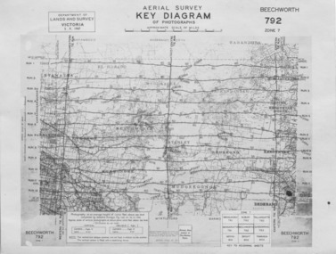 The Beechworth Burke Museum
Photograph - Aerial Survey, 5/9/1947
This image is an Aerial Survey, Key Diagram of Beechworth and surrounding area. Issued by Department of Lands and Survey, Victoria in 1947. Photographed at an average height of 12300 feet above sea level, areas depicted are; Beechworth, Stanley, Bruarong, Baranduda, Muagegonga, Myrtleford, Everton, Wooragee North Tarrawinge, Dederang, Kergunyah North, Kergunyah, Yackandandah, El-Dorado, Barambogie, Murmungee, Barwidgee, Oxley, CarraragarmungeeBlack and white rectangular photograph. Image is printed on matt photographic paper and has a white un-printed border. Obverse: AERIAL SURVEY, KEY DIAGRAM OF PHOTOGRAPHS, APPROXIMATE SCALE OF MILES / DEPARTMENT OF LANDS AND SURVEY VICTORIA 5.9.1947. BEECHWORTH 792 ZONE 7. Reverse: BMM7010.1 (written in pencil) aerial survey, beechworth, burke museum, department of lands and survey, victoria, 1947 -
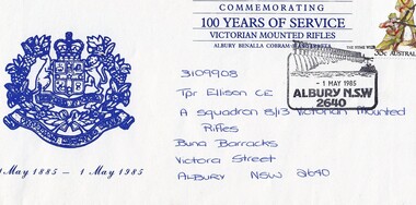 8th/13th Victorian Mounted Rifles Regimental Collection
Letter - First day cover
The Victorian Mounted Rifles was raised as the mounted arm of the Victorian Colonial defence force in 1885. It was under the command of Colonel Thomas Caradoc Rose (Tom) Price (1842-1911). Price was born in Tasmania, educated in Hobart Town and at Scotch College, Melbourne, before entering the East India Military College, Addiscombe, England. He was commissioned on 7 July 1861 in the Madras Infantry and began twenty years’ service in India with several regiments, retiring in April 1883. On his return to Victoria he was tasked with raising of a force of one thousand, to be known as the Victorian Mounted Rifles, and appointed a lieutenant-colonel in the Permanent Military Forces. Companies of the Victorian Mounted Rifles were raised in rural districts throughout Victoria. The soldiers were paid a small annual allowance and were required to provide their own horse. Many members served in contingent to the Boer War. After Federation the VMR was gathered up into the Australian Light Horse. First Day Cover commemorating 100 years of service Victorian Mounted Rifles Postmarked 1 May 1985 at Albury NSW 2640. Badge of 8/13 Victorian Mounted Rifles on left side of envelope.3109908 Tpr Ellison. C. E. A Squadron 8/13 Victorian Mounted Rifles Buna Barracks Victoria Street Albury NSW 2640military, vmr, postage, centenary, victoria -
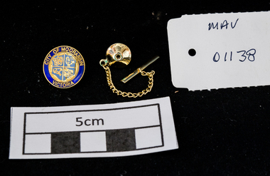 City of Moorabbin Historical Society (Operating the Box Cottage Museum)
Personal Effects, City of Moorabbin Tie pin c1990, c1990
A gold tie pin with anchor chain for City of Moorabbin, Victoria with MCC Coat of Arms in a Presentation clear plastic box with blue felt liningCITY OF MOORABBIN VICTORIA / Coat of Arms -
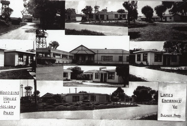 Lakes Entrance Historical Society
Photograph, Bulmer H D, 1950c
Black and white photograph collage of different views of Woodbine House, showing weatherboard buildings and water tower, lawns and large trees, ornate fencing. Lakes Entrance VictoriaWoodbine House and Holiday Park Lakes Entrance Victoriaguesthouses, architecture, fences -
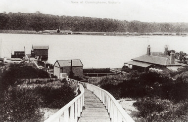 Lakes Entrance Historical Society
Photograph - New Works, 1910c
Also black and white copy 12.5 x 18 cm with smear of purple ink in top left hand corner, purchased from Helen ClothierTinted black and white photograph showing boardwalk from New Works Jetty over the sand dunes with small shed on jetty, small one room Boole Poole school on right of boardwalk and harbour master's house on right. Club Hotel on opposite foreshore and town on far right. Kalimna escarpment in background, at Lakes Entrance, Victoria.View of Cunninghame Victoriaboardwalk, waterways, ships and shipping, township, topography -
 Marysville & District Historical Society
Photograph (Item) - Black and white photograph, Unknown
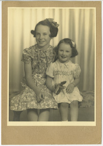
A black and white photograph of Jill and Marie Wallace from Marysville in Victoria.A black and white photograph of Jill and Marie Wallace from Marysville in Victoria. Jim Wallace was born in Dumfries in Scotland and emigrated to Australia with his family at age 6. He arrived and settled in Marysville in 1922 and ended up working for the Barton Brothers looking after their touring cars and their garage. He met Marj in 1928 and they married in 1930. Jim and another well-known local, Clarrie Smith, had spoken about showing the 'talkies' in the local hall and then subsequently had local builder, Harold Cuzens, build the Marysville Theatre in 1932. The Marysville Theatre was located on Murchison Street. The solid concrete building was used as a Theatre from 1932 to 1970. The building was then purchased by The Darmody Family and was used as an Arts and Crafts Centre for two years from 1975. The building was then purchased by Norman and Rosemary Fiske in 1977 and converted into a restaurant called The Pumpernickel. This building, along with most of the town, was destroyed in the 2009 Black Saturday bushfires. The Wallaces departed Marysville in 1980 for a new life in Ringwood, Victoria. Jill and Marie Wallace/ Marysville.marysville theatre, marysville, victoria, harold cuzens, jim wallace, darmody family, norman fiske, rosemary fiske, the pumpernickel, 2009 black saturday bushfires, marj wallace, marie wallace, jill wallace, barton brothers, clarrie smith -
 City of Moorabbin Historical Society (Operating the Box Cottage Museum)
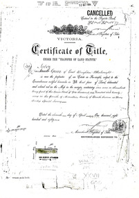
Document - Photocopy of Land Title 1881, c1881
This is a Certificate of Title for an acre of land in 'Tucker's Road' purchased by Jabez Gurr in 1881, in the area that was part of the Crown Block known as Henry Dendy's Special Survey 1841, in the Parish of Moorabbin, County of Bourke, Victoria. Following the 'Transfer of Land Statute' allotments in the area of Henry Dendy's Special Survey of 1841 were sold to early settlers. This Certificate of Title shows the passage of history in Moorabbin Shire . Jabez Gurr, a wheelwright, of East Brighton, now Bentleigh East, purchased an acre of land in 'Tucker's Road' , near Centre Road, in 1881. In 1889 he sold to a produce merchant, Robert Smith, and in April 1916 this block was purchased by William Henry George Box, a market gardener and relative of William and Elizabeth Box, who owned the land until 1926. The land was then purchased by Charles John Greenlaw Coates and remained with this family until 1971. All these Family names appear on Councils and Community Boards during the foundation and development of City of Moorabbin3 photocopied pages of the Certificate of Title for approximately 1 acre of land near the corner of Centre Road and Tucker Road, Parish of Moorabbin, County of Bourke, Victoria that was part of the 5,120 acre Henry Dendy Special Survey in Brighton in 1841 and purchased in 1881 by Jabez Gurr. It records subsequent proprietors up to 1971Stamped CANCELLED 12 OCT 1994 (top Right) / Entered in the Register Book / Vol.1245 Fol. 248877/ signed Henry Crowe / Assistant Registrar of Titles / Coat of Arms / VICTORIA / Certificate of Title / UNDER THE ' TRANSFER OF AND STATUTE' /dated ' eleventh day of April one thousand eight / hundred and eighty one' / signed 'Henry Crowe' / Assistant Registrar of Titles/ ENCUMBRANCES REFERRED TO / circular Stamp 'OFFICE OF TITLES VICTORIA' / Drawn and shaded on the left side is the area of land in "Tucker's" Road 3331/3 links fro Centre Road, 150 links x 6662/3 links / The measurements are in linksdendy henry, dendy's special survey 1841, brighton, moorabbin, bentleigh, market gardeners, early settlers, pioneers, wheelwrights, merchants, fruit gardens, markets, smith robert, box william henry george, gurr jabez, county of bourke, victoria, melbourne, land statutes, tucker road, centre road, box william, box elizabeth, box cottage museum -
 Robin Boyd Foundation
Slide, Robin Boyd
Colour slide in a mount. A Light Timber Construction School, Victoria, Australia, 1953-4. (Architect: Percy Everett.)victoria, slide -
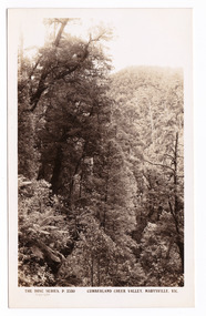 Marysville & District Historical Society
Postcard (item) - Black and white postcard, Rose Stereograph Company, Cumberland Creek Valley, Marysville, Vic, 1913-1967
A postcard in a series produced by the Rose Stereograph Company in Victoria, Australia as a souvenir of Marysville.A black and white photograph of a heavily forested valley leading up to a forested hill. The Cumberland Valley is near Cambarville which was a timber town near Marysville. Cambarville is notable for its giant mountain ash (Eucalyptus regnans) trees within the Cumberland Memorial Scenic Reserve, and relics from former sawmills and gold mining. The Big Culvert is located nearby on the Marysville - Woods Point Road, which was historically part of the Yarra Track. Cambarville was established as a timber mill town in the 1940s. Timber mill owners A Cameron and FJ Barton named Cambarville. They established the mill to salvage timber from trees destroyed in the 1939 bushfires. Cambarville was impacted by the 2009 Black Saturday bushfires and any remaining structures were destroyed.POST CARD The "Rose" Series/ De Luxe A Real Photograph/ Produced in Australia Published by the Rose Stereograph Co.,/ Armadale, Victoria.cumberland valley, marysville, victoria, p. 2330, cumberland creek, rose series postcard, postcard, souvenir, mountain ash, timber mill, mining, a cameron, fj barton, cambarville, big culvert, yarra track, black saturday bushfires, 1939 bushfires -
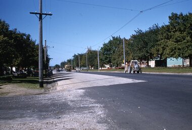 Ballarat Tramway Museum
Slide - 35mm slide/s, Ben Parle, 8/04/1958 12:00:00 AM
Kodachrome Transparency - 35mm slide - cardboard mount, with one side with red border and words "Kodachrome Transparency / Processed by Kodak" top and bottom. Photo taken by Ben Parle 8/4/1958, date stamped onto slide. Has slide No. "9" stamped in red in top corner. Photo of Ballarat 14, outbound Victoria St, just after top of hill with St. Alipius church in the background. Tram has the destination of Victoria St. Note the gravel condition of the outbound side of Victoria St. - roadworks? "Victoria St. Line" / "8-4-58"tramways, trams, victoria st, tram 14 -
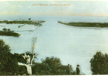 Lakes Entrance Historical Society
Postcard - The Entrance, 1900c
Also copy tinted postcard 10 x 15Coloured post card of the man made entrance through the sand dunes, taken from Jemmys Point. It shows the works and settlement at the entrance, Bullock Island and groynes to direct flow of lake waters towards entrance. Two men standing on Jemmys Point. Lakes Entrance VictoriaLakes Entrance, Cunninghame, Victoriaislands, waterways, topography -
 Bendigo Historical Society Inc.
Document - STRUCTURE OF BENDIGO GOLDFIELD BULLETIN NO. 47
Booklet, 36 pages, that describes the structure of the Bendigo Goldfield. Booklet is enclosed in an envelope. On front of booklet : 1923 Victoria, Department of Mines, Bulletins of the Geological Survey of Victoria, W. Baragwanath, Director. Structure of Bendigo Goldfield, by H. Herman, late Director of Geological Survey. Maps under catalogue number 3769 accompanied the booklet and are listed as 'plates' on the contents page. Plans and Sections to accompany Bulletin No 47, Structure of Bendigo Gold-Field, by H Herman, B.C.E., M.M.E., F.G.S., late Director of Geological Survey.Geological Survey of Victoriabendigo, gold mining, structure of goldfield, bendigo, goldfield, gold mining, geology -
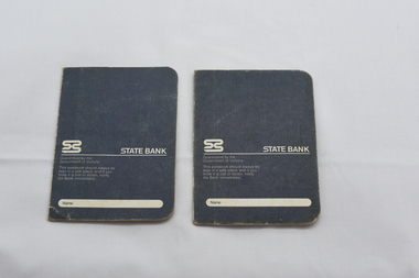
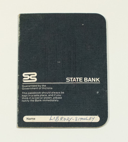
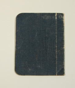 Stanley Athenaeum & Public Room
Administrative record - Old bank books, Bank Books - Athenaeum Committee No.610-01346
State Bank books with dark blue covers with State Bank of Victoria in white on front cover.State Bank of Victoria - 1976 - . Transactions for 'Athenaeum Committee Stanley' -
 Stanley Athenaeum & Public Room
Administrative record - Old bank books, Bank Books - Athenaeum Committee No.610-01346
State Bank books with dark blue covers with State Bank of Victoria in white on front cover.State Bank of Victoria - 1976 - ?. Transactions for 'Athenaeum Committee Stanley' -
 Stanley Athenaeum & Public Room
Administrative record - Old bank books, Bank Books - Athenaeum Committee No.610-01346
State Bank books with dark blue covers with State Bank of Victoria in white on front cover.State Bank of Victoria - 1976 - ?. Transactions for 'Athenaeum Committee Stanley' -
Stanley Athenaeum & Public Room
Administrative record - Old bank books, Bank Books - Athenaeum Committee No.610-01346
State Bank books with dark blue covers with State Bank of Victoria in white on front cover.State Bank of Victoria - 1976 - ?. Transactions for 'Athenaeum Committee Stanley' -
 Stanley Athenaeum & Public Room
Administrative record - Old bank books, Bank Books - Athenaeum Committee No.610-01346
State Bank books with dark blue covers with State Bank of Victoria in white on front cover.State Bank of Victoria - 1976 - ?. Transactions for 'Athenaeum Committee Stanley' -
 Stanley Athenaeum & Public Room
Administrative record - Old bank books, Bank Books - Athenaeum Committee No.610-01346
State Bank books with dark blue covers with State Bank of Victoria in white on front cover.State Bank of Victoria - 1993. Transactions for 'Athenaeum Committee Stanley' -
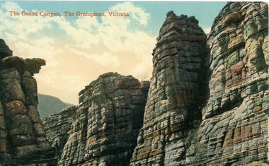 Stawell Historical Society Inc
Postcard, The Grand Canyon in the Grampians -- Postcard
The Grand Canyon, The Grampians, Victoria.Colour photograph of rocky canyon view. The Grand Canyon, The Grampians, Victoria. The Valentine & Sons' Publishing Co., Ltd., Victoria. halls gap grampians -
 Uniting Church Archives - Synod of Victoria
Booklet - Methdodist Girls' Comardeship, Hunkin, Ellis & King, Second and Third Degree Services Ritual, 1938
Contents: Foreward; In a hall; in a church; points to be observed; Methodist Girls' Comradeship Degree service Ritual Third Degree; Second Degree.Buff colour soft covered booklet of eight pages.The inside cover has the Synod Archives Victoria stamp. non-fictionContents: Foreward; In a hall; in a church; points to be observed; Methodist Girls' Comradeship Degree service Ritual Third Degree; Second Degree.handbooks, methodist church of australasia, methodist girls' comradeship -
 Warrnambool and District Historical Society Inc.
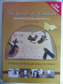
Book, Streets of Hamilton, 2007 (revised and reprinted 2009)
This is a book providing information on the streets of Hamilton, Victoria and the origin of the names. Hamilton is a city in Western Victoria at the intersection of the Glenelg Highway and the Henty Highway. European settlement began with the arrival of pastoralists following the 1836 explorations of Major Thomas Mitchell. The Wedge family in 1839 had the property ‘The Grange’ which covered the site of Hamilton today. The town was gazetted in 1851 and named after a place in Scotland. Hamilton Victoria is the centre of a sheep-grazing and agricultural district. The book won an award in the 2008 Victorian Community History Awards. This book is of interest as it gives information on the Hamilton streets and the origin of their names. The history of Hamilton is of particular interest to those also living in the Western District. The book will be a useful research tool. This is a soft cover book of 174 pages. The back cover has a white background with black and white photographs of five local Hamilton people. The front cover has a yellow and brown background with black and white photographs of five local Hamilton people, an outline of a map of Victoria and a photograph of a map of the Hamilton area with some artefacts placed on the map. The book contains an Introduction, a Preface, a Foreword, an Early Days Overview, a list of Contents, a list of the streets in alphabetical order with information on the origin of the names, two Appendices and an Index. The book has many black and white photographs and sketches. Front Cover: ‘2nd Edition’ ‘The Streets of Hamilton’ ‘Western Victoria Australia’ ‘By John McKay’ ‘A History of the People behind the Names’hamilton, victoria, john mckay, street names of hamilton, warrnambool -
University of Melbourne, Burnley Campus Archives
Document, Guidelines for the Development of Agricultural Apprenticeship Courses, 1976
Prepared by Curriculum and Research Branch and Industrial Training Commission of Victoria,156 pp.agricultural education, apprenticeship, victoria -
 Bendigo Historical Society Inc.
Document - TED BEATTIE COLLECTION: INFORMATION SHEET, Pre 1980s
Tourist Information Sheet entitled 'Bendigo, Victoria, Australia' Descriptive Notes on Bendigobendigo, victoria, tourist -
 Marysville & District Historical Society
Photograph (Item) - Black and white photograph, Unknown
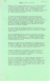
A black and white photograph taken outside Barton's Store in Marysville in Victoria.A black and white photograph taken outside Barton's Store in Marysville in Victoria. Thomas John Barton was born in 1836 in Gloucestershire and after his father died in 1850 arrived in Melbourne in 1852 along with his mother, adult sisters, younger brothers, his uncle, his uncle's wife Suzanna and their family. Thomas tried gold mining at Woods Point but found it too difficult. He then partnered with Ewen Hugh Cameron to provide the miners with meat. In 1864 they purchased a plot of land in Marysville and set up a butchers/abattoirs and from there began their business of taking supplies to the miners at the nearby Woods Point and Jamieson goldfields. In 1865 the business was firmly established and Thomas married Selina Croker at Heidelberg and brought her back to Marysville. Their first home was 'The Chestnuts', which included the store, and was situated on the town side next to the Steavenson River. Sadly, in 1876 Selina died of complications after giving birth to their sixth child. Thomas was in need of a nanny to care for his six children, including the newborn baby, and so he employed Emily Ada Sparke, who is the eldest daughter of the local school teacher. Thomas and Emily subsequently marry in 1878 and they go on to have a further 10 children over the next several years. Thomas assisted in the establishment of the first school in Marysville in 1870 and remained a very active member of the community including as a Councillor for the Shire of Healesville, Shire President and he was also appointed as a Justice of the Peace. Thomas died in Carlton in 1911. After their father's death, his sons Fred and Frank took over the family business, which was then known as Barton Bros Store which continued to operate until sometime in the 1970's.marysville, victoria, barton's store, thomas john barton, ewen hugh cameron, woods point, jamieson, gold mining, goldfields, selina croker, the chestnuts, emily ada sparke, shire of healesville, fred barton, frank barton, barton bros store, francis adam barton, frederick john barton, photograph -
 Marysville & District Historical Society
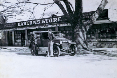
Postcard (item) - Black and white postcard, Rose Stereograph Company, By the Wolfram Track, Marysville, Vic, 1913-1967
A postcard in a series produced by the Rose Stereograph Company in Victoria, Australia as a souvenir of Marysville.A black and white photograph of a part of the forest that the Wolfram Track, which is part of the Wilks Creek Walking Track, runs through. The Wilks Creek Walking Track is in Marysville in Victoria. The Wolfram Track is named after the Wilks Creek Wolfram Mine which opened in around 1894. Wolframite is one of the principle ores of tungsten. The discovery was made in Wolfram Creek by a Mr Robinson who was probably a local of the district. Four creeks eventually proved to carry alluvial deposits of the ore; Wolfram Creek, Opas Creek, Quartz Creek and Main Creek. These creeks run south-east into Deep Creek, a tributary of the O'Shannassy River which, in turn, runs into the Yarra River.POST CARD The "Rose" Series/ De Luxe A Real Photograph/ Produced in Australia Published by the Rose Stereograph Co.,/ Armadale, Victoria.wolfram track, wilks creek walking track, walking track, marysville, victoria, p. 2334, rose series postcard, postcard, souvenir, p. 2332, wolframite, wolfram creek, opas creek, quartz creek, main creek, deep creek, o'shannassy river, yarra river, mining -
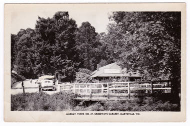 Marysville & District Historical Society
Postcard (Item) - Black and white postcard, Murray Views, MURRAY VIEWS NO. 27. CROSSWAYS CABARET, MARYSVILLE, VIC, Unknown
A black and white postcard of the Crossways Cabaret in Marysville in Victoria published by Murray Views. The Crossways was built in the early 1920s and is the oldest building in Marysville. The Crossways historic inn survived the 2009 Black Saturday bushfires thanks to the efforts of its c-owner Greg Cherry and, in the days after the fires, provided a much-needed refuge to the Marysville community and firefighters. This postcard was produced by Murray Views in Gympie in Queensland as a souvenir of Marysville.A black and white postcard of the Crossways Cabaret in Marysville in Victoria published by Murray Views.marysville, victoria, australia, postcard, souvenir, crossways cabaret, crossways historic inn, crossways country inn, murray views no. 27, accommodation, 2009 black saturday bushfires -
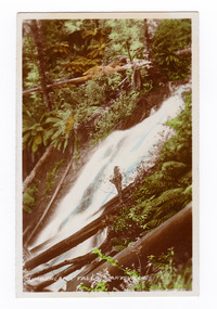 Marysville & District Historical Society
Photograph (item) - Colour tinted photograph, Valentine Publishing Co. Pty. Ltd, Cumberland Falls, Marysville. No.3, 1923-1963
An early colour tinted photograph of the Cumberland Falls near Marysville in Victoria. This photograph was published by the Valentine Publishing Co Pty. Ltd. as a souvenir of Marysville.An early colour tinted photograph of the Cumberland Falls near Marysville in Victoria. These falls are located on the Marysville-Wood's Point Road. Cambarville is notable for its giant mountain ash (Eucalyptus regnans) trees within the Cumberland Memorial Scenic Reserve, and relics from former sawmills and gold mining. The Big Culvert is located nearby on the Marysville-Woods Point Road, which was historically part of the Yarra Track. Cambarville was established as a timber mill town in the 1940s. Timber mill owners A Cameron and FJ Barton named Cambarville. They established the mill to salvage timber from trees destroyed in the 1939 bushfires. Cambarville was impacted by the 2009 Black Saturday bushfires and any remaining structures were destroyed.cumberland falls, waterfalls, marysville, victoria, valentine publishing co, souvenir, a cameron, fj barton, cambarville, marysville-wood's point road, eucalyptus regnans, big culvert, yarra track, timber milling, 1939 bushfires, black saturday bushfires -
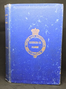 Kilmore Historical Society
LICENSING LAW IN VICTORIA, Licensing Law in Australia, 1908
Blue textured cloth-bound hardcover book, worn at extremities. Loose front hinge. Foxing inside back & front covers. 284 pp. Fair condition.Stamp. 'Law Department Victoria', front flyleaf, top of Preface page and through out book. Front cover, gilt print, 'Crown Law Department. Victoria./Licensing Ct./ Kilmore'.licensing law, victoria, kilmore court house library -
 Marysville & District Historical Society
Photograph (Item) - Black and white photograph, 1932
A black and white photograph of a member of the Branchflower Family who resided in Marysville in Victoria.A black and white photograph of a member of the Branchflower Family who resided in Marysville in Victoria. Thomas was born in London in 1896. He arrived in Australia in 1922 with his wife Alice and baby Peggy. Thomas spent the early 1930s in Marysville as a builder, in particular on Eric Dowdle's guesthouses, and built his family a house on the Buxton road. He built The Log Cabin in the traditional way with no nails. It was built for Gwendoline Pitman after the death of her father Clarence Pitman and the disappearance of her sister Olive in July 1926. Gwendoline operated an artist and souvenir shop in the newly built Log Cabin in partnership with Peter Mackey who was a Melbourne optician and artist. Alice died in 1944 and Thomas married Irene Sutherland in 1945; they had three children. Thomas Henry Branchflower died in Mont Albert in 1970. At the time of his death, he was a building assessor.Alice Branchflower/ Blackie/ Marysville/ 1932the log cabin, marysville, victoria, thomas henry branchflower, gerald branchflower, mary chain, gwendoline pitman, clarence pitman, kooringa guesthouse, olive pitman, wilbur anderson, peter mackey, alice maude branchflower, alice maude humm, collingwood, pianomaker, preston, pianoforte maker, cabinetmaker, peggy branchflower, kenneth branchflower, irene sutherland, irene branchflower, mont albert, building assessor -
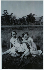 Marysville & District Historical Society
Photograph (Item) - Black and white photograph, Unknown
A black and white photograph of members of the Branchflower Family who resided in Marysville in Victoria.A black and white photograph of members of the Branchflower Family who resided in Marysville in Victoria. Thomas was born in London in 1896. He arrived in Australia in 1922 with his wife Alice and baby Peggy. Thomas spent the early 1930s in Marysville as a builder, in particular on Eric Dowdle's guesthouses, and built his family a house on the Buxton road. He built The Log Cabin in the traditional way with no nails. It was built for Gwendoline Pitman after the death of her father Clarence Pitman and the disappearance of her sister Olive in July 1926. Gwendoline operated an artist and souvenir shop in the newly built Log Cabin in partnership with Peter Mackey who was a Melbourne optician and artist. Alice died in 1944 and Thomas married Irene Sutherland in 1945; they had three children. Thomas Henry Branchflower died in Mont Albert in 1970. At the time of his death, he was a building assessor.the log cabin, marysville, victoria, thomas henry branchflower, gerald branchflower, mary chain, gwendoline pitman, clarence pitman, kooringa guesthouse, olive pitman, wilbur anderson, peter mackey, alice maude branchflower, alice maude humm, collingwood, pianomaker, preston, pianoforte maker, cabinetmaker, peggy branchflower, kenneth branchflower, irene sutherland, irene branchflower, mont albert, building assessor