Showing 13827 items
matching tasmanian-built
-
 Kew Historical Society Inc
Photograph - Yarra River at Kew East, Ron Setford, 1960
Ron Setford and his wife Grace Setford lived in Tanner Avenue, East Kew, from c.1946 to c.1995. A keen photographer, he recorded the changing face of Kew over a 20 year period. Apart from 30 photographs of built structures and places in Kew dating from 1960 and 1961, 145 of his 35mm colour slides chronicle the development of the Eastern Freeway through the Yarra Valley over a five year period from c.1972 to c.1977. This important collection was donated to the Society by his granddaughter in 2025.This collection of 175 35mm slides is of local and statewide significance, owing to its subject matter, particularly the major development of road transport infrastructure during the 1970s with the construction of the Eastern Freeway. The photographer also took care to annotate and date most of his slides which enable the researcher to pinpoint temporal and spatial locations.Nilron setford, photographs -- kew (vic.) -- 1960s, yarra river -- kew east (vic.) -
 Kew Historical Society Inc
Photograph - Willsmere Park, Ron Setford, 1960
Ron Setford and his wife Grace Setford lived in Tanner Avenue, East Kew, from c.1946 to c.1995. A keen photographer, he recorded the changing face of Kew over a 20 year period. Apart from 30 photographs of built structures and places in Kew dating from 1960 and 1961, 145 of his 35mm colour slides chronicle the development of the Eastern Freeway through the Yarra Valley over a five year period from c.1972 to c.1977. This important collection was donated to the Society by his granddaughter in 2025.This collection of 175 35mm slides is of local and statewide significance, owing to its subject matter, particularly the major development of road transport infrastructure during the 1970s with the construction of the Eastern Freeway. The photographer also took care to annotate and date most of his slides which enable the researcher to pinpoint temporal and spatial locations.Nilron setford, photographs -- kew (vic.) -- 1960s, willsmere park -
 Bendigo Historical Society Inc.
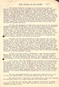
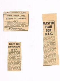
Document - LA TROBE UNIVERSITY BENDIGO COLLECTION: HISTORY OF BENDIGO TEACHERS' COLLEGE
The first teachers college established in regional Victoria in 1926. Originally it was at the Long Gully Primary School. The college catered for female students until 1946 when 8 male students were included. Comersdale:- Originally built by James Hendry and named after his pastoral property at Yakool, in NSW. It was acquired by the Bendigo Teachers College in 1949 and in 1950 began as the second hostel for student teachers. Jessie Carnegie Burnett (1902-11/9/1994):- was the daughter of David Burnett and his wife Bridget.She was born, trained as a teacher and died in BendigoA brown envelope containing correspondence and various contributions pertaining to the history of Bendigo Teachers' College largely written by Miss J.C. Burnett. It includes a brief history of the college, staff profiles, reports on reunions and subject description. 1926 - 1972bendigo, education, bendigo teachers' college history, la trobe university bendigo collection, collection, bendigo teachers' college, teaching, history, students, bendigo teachers' college history, correspondence, bendigo, tertiary education, miss j. c. burnett -
 Bendigo Historical Society Inc.
Document - LA TROBE UNIVERSITY BENDIGO COLLECTION: BENDIGO TEACHERS' COLLEGE HISTORY
The first teachers college established in regional Victoria in 1926. Originally it was at the Long Gully Primary School. The college catered for female students until 1946 when 8 male students were included. Comersdale:- Originally built by James Hendry and named after his pastoral property at Yakool, in NSW. It was acquired by the Bendigo Teachers College in 1949 and in 1950 began as the second hostel for student teachers. Jessie Carnegie Burnett (1902-11/9/1994):- was the daughter of David Burnett and his wife Bridget.She was born, trained as a teacher and died in BendigoA brown manilla folder with the word "Comersdale" on the front. It contains a variety of correspondence, Bendigo Teachers' College staff profiles, and other items all relating to the history of the college and organised by Miss J.C. Burnett.1926 - 1972.bendigo, education, bendigo teachers' college, la trobe university bendigo collection, collection, bendigo teachers' college history, bendigo, education, staff, students, correspondence -
 Kew Historical Society Inc
Photograph - South Esk - Cotham Road (Kew), Ron Setford, 1967
Ron Setford and his wife Grace Setford lived in Tanner Avenue, East Kew, from c.1946 to c.1995. A keen photographer, he recorded the changing face of Kew over a 20 year period. Apart from 30 photographs of built structures and places in Kew dating from 1960 and 1961, 145 of his 35mm colour slides chronicle the development of the Eastern Freeway through the Yarra Valley over a five year period from c.1972 to c.1977. This important collection was donated to the Society by his granddaughter in 2025.This collection of 175 35mm slides is of local and statewide significance, owing to its subject matter, particularly the major development of road transport infrastructure during the 1970s with the construction of the Eastern Freeway. The photographer also took care to annotate and date most of his slides which enable the researcher to pinpoint temporal and spatial locations."South Esk / May 1967"ron setford, south esk - kew (vic.), historic houses -- kew (vic.) -
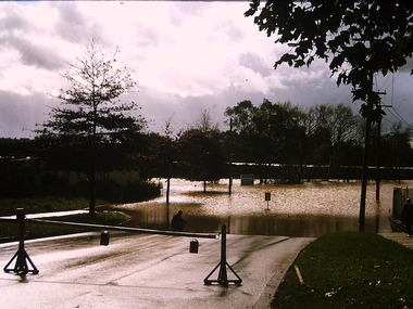 Kew Historical Society Inc
Photograph - Flooding - Kilby Road (Kew), Ron Setford, 1974
Ron Setford and his wife Grace Setford lived in Tanner Avenue, East Kew, from c.1946 to c.1995. A keen photographer, he recorded the changing face of Kew over a 20 year period. Apart from 30 photographs of built structures and places in Kew dating from 1960 and 1961, 145 of his 35mm colour slides chronicle the development of the Eastern Freeway through the Yarra Valley over a five year period from c.1972 to c.1977. This important collection was donated to the Society by his granddaughter in 2025.This collection of 175 35mm slides is of local and statewide significance, owing to its subject matter, particularly the major development of road transport infrastructure during the 1970s with the construction of the Eastern Freeway. The photographer also took care to annotate and date most of his slides which enable the researcher to pinpoint temporal and spatial locations."Flood Kilby Rd / May 74"ron setford, floods -- kew (vic.), kilby road -- kew (vic.) -
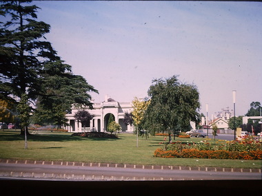
 Kew Historical Society Inc
Photograph - Kew City Hall, Ron Setford
Ron Setford and his wife Grace Setford lived in Tanner Avenue, East Kew, from c.1946 to c.1995. A keen photographer, he recorded the changing face of Kew over a 20 year period. Apart from 30 photographs of built structures and places in Kew dating from 1960 and 1961, 145 of his 35mm colour slides chronicle the development of the Eastern Freeway through the Yarra Valley over a five year period from c.1972 to c.1977. This important collection was donated to the Society by his granddaughter in 2025.This collection of 175 35mm slides is of local and statewide significance, owing to its subject matter, particularly the major development of road transport infrastructure during the 1970s with the construction of the Eastern Freeway. The photographer also took care to annotate and date most of his slides which enable the researcher to pinpoint temporal and spatial locations.The Kew City Hall in Cotham Road, designed by Harold Bartlett, was intended as the initial phase in a scheme to develop an entire civic precinct. This was representative of a widely-held belief, of the immediate post-war era, that a district's civic centre should be precisely that – not just a single grand building for official use, but a dedicated precinct providing a range of community facilities as well as an administrative function. The Kew masterplan was later abandoned. The City Hall was designed to cater for public or official functions. Its interior had a small stage at one end for intimate theatrical productions, a larger stage at the other (with sunken orchestra pit) for musical performances, plus the most up-to-date equipment for live TV transmission.Nilron setford, photographs -- kew (vic.) -- 1960s -
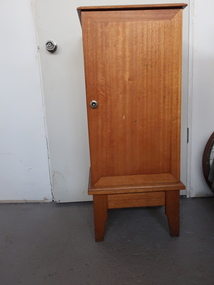 Kiewa Valley Historical Society
Cabinet - Vinyl Records
The cabinet appears to be homemade and purposely built for the storage of a collection of vinyl records. The records are stored vertically in a 'holder' with a rectangular wooden base with soft covered wire strips well spaced and each extended to fit up to 50 records. See KVHS 18 . The stands then fit into the cabinet with the base of the holder resting on wooden ledges glued on each side allowing the records to fit in all directions. There are two levels - one on the bottom and one halfway up. Holding approximately 100 records altogether. The cabinet's door is opened with a silver push button latch. Many men made their own furniture as they had the equipment and experience to do so. During the 1950s vinyl records were played to entertain families and to educate children in the areas of music and dance. Mt Beauty didn't have TV until much later than the cities and furniture wasn't always available at the local shops.Wooden cabinet with 4 legs and a door with a silver push button latch. Inside are small ledges on each side at the bottom and halfway up.vinyl records, music, wooden cabinet -
 Stawell Historical Society Inc
Photograph, St Patricks Church Residence 2000 -- 2 Photos -- Coloured
Six photos of the exterior and interior of Thomas Kinsella's past residence in grounds of St Patrick's Catholic Church taken 2000. The house "Donanore" was built in 1900 by Thomas Kinsella and was the family residence for many years. The Stawell news of 26.1.1924 reported the arrival of nuns from the order of Sisters of Joseph. The nuns resided in the house for many years. Three of the six photos are of the interior. One of the front door surrounded by stained glass windows. Another a detail of an external door. The third a view of a statue at the end of the hallway. The photos are in Album 2 p. 52 & 53.Six colour photos taken in 2000 of "Donanore" Tomas Kinsella's residence in the grounds of St Patrick's Catholic Church. Three different views of the house and three photos of the interior entrance and hallway. The house is a red brick house with grey trim and a verandah out the front with a slate roof. stawell -
 Eltham District Historical Society Inc
Photograph - Digital Photograph, Alan King, Garden Hill, Eltham-Yarra Glen Road, Kangaroo Ground, 3 February 2008
The original house was built around 1850 was one of Kangaroo Ground's earliest homes, part of which remains today. Built by Scottish farmer Andrew Harkness who acquired the property in 1849 at the top of the hill with magnificent panoramic views as far as Kinglake, the same year he married Sarah Oswin. The property was known as Garden Hill from at least 1865. Andrew and Sarah had four sons and five daughters. Harkness was a founder of the Kangaroo Ground School and one of the first to suggest establishing the Eltham District Road Board (1858-71) of which he was a member, the pre-cursor to the Shire of Eltham (1871-1994). He was also a Trustee of the Kangaroo Ground Cemetery. His daughter Fanny married farmer Alexander White who purchased the property in 1893. Alexander White died in 1906 and ownership transferred to Fanny White. Son, Robert White was a Councillor of the Shire of Eltham at the time the Shire acquired two acres of land on the adjacent property from the Mess brothers for the creation of the Shire of Eltham Memorial Park (1921) in which the Shire of Eltham War Memoirial tower was erected (1926). Fanny White donated a small section of land from the Garden Hill property to facilitate entry access to the park. The White family sold the property to Sir Herbert Gepp in 1925. Covered under Heritage Overlay, Nillumbik Planning Scheme. Published: Nillumbik Now and Then / Marguerite Marshall 2008; photographs Alan King with Marguerite Marshall.; p29 Garden Hill, on Yarra Glen Road, Kangaroo Ground, near the War Memorial is well named. The old house and gardens overlook a magnificent panorama extending to Kinglake. The original house, built around 1850, was one of Kangaroo Ground’s earliest, and part of it remains in today’s timber house. The house was built by the early and prominent settler Andrew Harkness. Later it was occupied for a long time by Sir Herbert Gepp, renowned Australia wide.1 Harkness and Gepp are buried in the Kangaroo Ground Cemetery. Scottish farmer Harkness, who was born in 1817, acquired this property in 18492 and he and his family occupied it until the early 1920s. Harkness cleared its 152 acres (61.4 ha), fenced it and grazed sheep and cattle. Harkness proved a valuable community member. When only ten families lived in the district, he and other settlers set up a school in 1852, with Andrew Ross as the first teacher. Harkness was also one of the first to suggest establishing the Eltham District Road Board, of which he was a member for around 15 years. He was also a trustee of the Kangaroo Ground Cemetery. Harkness married in 1854 and had four sons and five daughters. The first part of the timber house he built included a kitchen-living room and a parlor. The living room’s large fireplace was bricked-in and modernised in 1940. Beside it is the old baker’s oven with its original iron door replaced by a wooden one. It is thought two wattle-and-daub huts, used for a bedroom and bathroom, were built to the west. Harkness’ son-in-law, farmer Alexander White, who had seven sons, bought the property in 1893. Harkness’ grand-daughter Flora married Ewen Cameron who became Minister for Health and was later knighted; he was not related to Ewen Hugh Cameron, a Member of the Legislative Assembly. In 1923 the White family sold the property, called Kilby Park, to Sir Herbert Gepp, who renamed it Garden Hill. Gepp used the property, which was still on the original New South Wales title, as a hobby farm. Robert White stayed on to manage the farm for a while, living in a house on the property. Gepp was born in 1877 and at 16 years began working as a junior chemist with the Australian Explosives and Chemical Company at Deer Park near Melbourne. Gepp was a pioneer in applying enlightened labour policies in industry. He initiated the Broken Hill Progress Association, to improve living conditions. It laid the ground work for the welfare schemes pursued by companies after World War One. During the mid 20th century Gepp was the most prominent liberal thinker associated with conservative politics. As a friend of Prime Minister John Curtin, he contributed to post-war reconstruction. Gepp returned to private industry and retired in 1950. Gepp made significant contributions to the solution of the great metallurgical problems of the mining industry. He was an advocate of the role of science in industry, government and the economy and helped to establish several organizations including the CSIR and the Institute of Public Affairs.3 After Sir Herbert died in 1954 his son Orwell continued to farm the property part-time. When Lady Gepp died in 1963, the land was divided among the five children, although Orwell continued to farm it as a hobby. In 1966, a daughter, Mardi Gething, now married, settled in the house. Another daughter, Kathleen, built her house close by on the property. After the Board of Works designated the property as part of a reserve for a possible reservoir, the family sold all, except the minimum 20 acres allowed, to the Board in the 1970s. Orwell then leased what was the family property from the Board to continue grazing. The two sisters and brother continued to live on the property.This collection of almost 130 photos about places and people within the Shire of Nillumbik, an urban and rural municipality in Melbourne's north, contributes to an understanding of the history of the Shire. Published in 2008 immediately prior to the Black Saturday bushfires of February 7, 2009, it documents sites that were impacted, and in some cases destroyed by the fires. It includes photographs taken especially for the publication, creating a unique time capsule representing the Shire in the early 21st century. It remains the most recent comprehenesive publication devoted to the Shire's history connecting local residents to the past. nillumbik now and then (marshall-king) collection, kangaroo ground -
 Eltham District Historical Society Inc
Photograph - Digital Photograph, Marguerite Marshall, Former home of Professor William MacMahon Ball, York Street, Eltham, 24 May 2007
Situated at the eastern end of York Street, Eltham, 'Shinrone', the former home of Professor William (Mac) MacMahon Ball was one of the first in the Shire of Eltham to incorporate mud-brick. Professor MacMahon Ball, a political scientist, writer, broadcaster and diplomat and family moved to York Street, Eltham in 1945 into a timber cottage built around the 1890s and in poor repair. Mac asked Alistair Knox to renovate the home and he expanded the living area and added verandahs. In 1948 Montsalvat artist and sculptor Sonia Skipper supervised the building of most of the mud-brick studio. Neighbour Gordon Ford made the mud-bricks. Mac also asked John Harcourt, who had worked with him as a journalist in shortwave broadcasting, to build a pise (rammed earth) and stone addition to the largely timber house. Harcourt built two bedrooms - including an attic bedroom - a balcony with a shower and toilet, a nd a fireplace and chimney of local stone. Published: Nillumbik Now and Then / Marguerite Marshall 2008; photographs Alan King with Marguerite Marshall.; p141 At the eastern tip of York Street, Eltham, stands Shinrone, the former home of one of Australia’s intellectual leaders. Professor William Macmahon Ball, was one of the first to bring Asia as a foreign policy issue to the Australian public.1 He was a political scientist, writer, broadcaster and diplomat. The house was one of the first in Eltham Shire to incorporate mud-brick,2 because of the acute shortage of building materials after World War Two. Its novice builders later become leaders in Eltham’s built and garden design. Mac (as he was usually called), who was the son of a Church of England minister, was born in Casterton, Victoria in 1901 and died in 1986. In 1945 he helped establish the United Nations, as political consultant to the Australian Delegation at the San Francisco Conference.3 Then in 1946 Mac was appointed British Commonwealth Representative on the Allied Council for Japan, which is recorded in detail in his diary.4 In 1948 Mac led an Australian Government Goodwill Mission to South East Asia. However, Mac was perhaps most successful as an academic and public speaker.5 He was a commentator on the Australian Broadcasting Commission, from the early 1930s to the early 1960s. He was also Controller of the Short-Wave Broadcasting Unit during World War Two, which later became Radio Australia. From 1923 he taught at The University of Melbourne, then became foundation Professor of Political Science in 1949 and was Chair until his retirement in 1968.6 In 1942, as the government expected a Japanese invasion, Mac’s wife Katrine and their only child Jenny, moved from Kew to Eltham as temporary evacuees. However Mac and Katrine lived in Eltham for almost the rest of their lives. After staying with friends, they rented a house in Reynolds Road, where, as it was wartime, they needed to keep horses for transport and a cow and poultry for milk and eggs. In 1945 the family moved to the house at York Street, which was then a timber cottage, built around the 1890s and in poor repair. The underground well, cellar and part of the garden are all that remain of what stood on the original 18 acre (7.3ha) allotment. Thanks largely to Katrine’s hard work, the house was gradually renovated and extended. The long rambling house was partially built by several young neighbours, who were inspired by the cheap mud-brick and stone building style of Montsalvat, the Eltham artists’ colony. Mac asked Alistair Knox to renovate Shinrone, named after an Irish village near Katrine’s family home. Knox later popularised the mud-brick style of house construction, for which Eltham became known. He expanded the living area and added verandas. In 1948 Montsalvat artist and sculptor Sonia Skipper supervised the building of most of the mud-brick studio. Another neighbour, Gordon Ford, who was to have a major influence on the Australian garden style, made the mud-bricks. Mac also asked John Harcourt, who had worked with him as a journalist in short-wave broadcasting, to build a pisé (rammed earth) and stone addition to the largely timber house. Harcourt built two bedrooms – including an attic bedroom – a balcony with a shower and toilet, and a fireplace and chimney of local sandstone. With pioneering work naturally came mistakes, including one particularly dramatic incident when Harcourt was building walls with unsupported sections. Jenny Ellis, Mac’s daughter, remembers being awakened from sleep by a thundering shudder. The wall of her room had fallen down – fortunately away from her! In 1950 artist Peter Glass – another neighbour and later landscape designer – built Katrine a mud-brick pottery. As a result, the house features at one end Harcourt’s characteristic steep gable roof, while at the other the flatter construction characteristic of Knox. Mac referred to the home as the Eltham ‘experimental building site’.7 Surprisingly, the combination works, perhaps partly because it has the warm inviting feel of timber, mud-brick and stone.This collection of almost 130 photos about places and people within the Shire of Nillumbik, an urban and rural municipality in Melbourne's north, contributes to an understanding of the history of the Shire. Published in 2008 immediately prior to the Black Saturday bushfires of February 7, 2009, it documents sites that were impacted, and in some cases destroyed by the fires. It includes photographs taken especially for the publication, creating a unique time capsule representing the Shire in the early 21st century. It remains the most recent comprehenesive publication devoted to the Shire's history connecting local residents to the past. nillumbik now and then (marshall-king) collection, eltham, alistair knox, gordon ford, john harcourt, mudbrick construction, pise construction, professor macmahon ball, shinrone, sonia skipper, york street -
 City of Moorabbin Historical Society (Operating the Box Cottage Museum)
Newsletter, City of Moorabbin Historical Society Aug 2010 pdf, August 2010
The City of Moorabbin Historical Society was formed c 1960 by a group of Moorabbin residents who were concerned that the history of the area should be preserved. A good response to a call for items related to the historical area of Moorabbin Shire brought donations of a wide variety of artefacts which are now preserved by the current members of CMHS at Box Cottage Museum . Helen Stanley, Secretary of CMHS, began producing a Newsletter for members in April 2007 to provide current information and well researched items of historical interest Helen Stanley has produced a bi-monthly Newsletter, 2007 - 2013, for the members of the City of Moorabbin Historical Society that contains well researched interesting historical items, notification of upcoming events, current advice from Royal Australian Historical Society , Museums Australia Victoria and activities of Local Historical Societies. The Newsletter is an important record of the activities of the CMHS The issue of Chinese migration was very inflamed and caused much distress to local market gardeners c1900. Issue 18 of the bi-monthly, City of Moorabbin Historical Society Newsletter produced by Society member and Secretary, Mrs Helen Stanley in August 2010. Notice re meeting august 29th. Items of Interest explain that volunteer Ronnie has completed The CMHS site on Vicnet, Dennis Maynard has built display benches for the Barn and repaired school desks, Mr Neil Follett has donated a photograph of the Tuck family and ‘Baydon Hill’ c1800, Trish Smythe, manager Kingston Library, has displayed Posters and Flyers about Box Cottage Museum, and 3 bridal gowns are now on display at Box Cottage. Robina Naughton has researched a photograph , 1906, of His Excellency Hwang Hon Cheng, Chinese Commissioner, donated by Frank and Lorna Thatcher. A copy of this photograph has been sent to Sophie Couchman, Curator of Museum Of Chinese History. Helen has compiled a 3 page history of Hwang Hon Cheng and the Chinese in Victoria 1840- 1906.CITY of MOORABBIN HISTORICAL SOCIETY / AUGUST 2010 NEWSLETTER city of moorabbin historical society, stanley helen, melbourne, moorabbin, brighton, cheltenham, ormond, bentleigh, mckinnon, kingston, clothing, bridal gowns, weddings, market gardeners, pioneers, early settlers, moorabbin shire, box cottage museum, city of moorabbin, box william, glen eira historical society, vicnet, brighton historical society, museum of chinese history, hwang hon cheng, follett neil, thatcher frank, thatcher lorna, smythe trish, city of kingston library, the grange, baydon hill, tuck family -
 Bendigo Historical Society Inc.
Document - LONG GULLY HISTORY GROUP COLLECTION: A VICTORIAN DREAM HOME
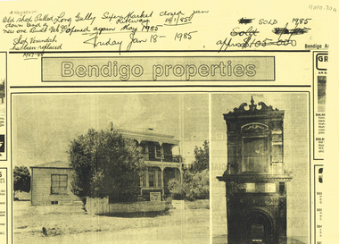
Photocopy of a newspaper article titled A Victorian dream-home by Richard Foord. The article is an estate agent, Craig Tweed & Co Pty Ltd, ad about a house called Kilhallen which had been in the Truscott family for four generations. The house and the building materials are described. A photo shows the back of the two story house with a small room added on at the back. On the back of the page titled Bendigo properties is a photo of a two story house with ironlace on the verandas, a tree partly obscuring the house and a single story weatherboard building beside it. An auction sale sign is on the front fence. The second photo shows an ornate fireplace with tall carving above it. Written at the top of the page is: A Truscott. Old shop pulled down and a new one built Feb 90. Shop verandah has been replaced 1987-88. Long Gully Super Market Riteway Jan 14/1/85. opened again May 1985. Friday Jan 18 1985. Sold 1985.bendigo, history, long gully history group, the long gully history group - a victorian dream home, richard foord, anthony truscott, kilhallen, craig tweed & co pty ltd -
 Ballarat Heritage Services
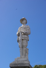
Photograph - Colour photograph, Clare Gervasoni, Apollo Bay War Memorial, 27/01/2013
This memorial was erected by the residents of Apollo Bay and District in 1922.Colour photograph of the War Memorial at Apollo Bay, that features a scuplture of an Australian soldier with slouch hat and holding a rifle. It includes a list of those who served during World War One and World War Two. A characteristic figurative monument, the memorial comprises a single standing soldier, looking down the main street, a top a polished granite pedestal with honour roll set on a huge rock faced granite block.The memorial is fenced by heavy set square concrete bollards supporting heavy gauge chain between each. Built by J. Wilson & Co. of Bendigo, the Apollo Bay Memorial depicts the lone soldier, a typical symbol of the sentiments of communities who had lost faith in heroism and had learnt to recognise the level of loss caused by war amongst ordinary volunteers. This recognition,which occurred throughout Australia, marked a turning point as the 'unknown soldier' was increasingly commemorated instead of military leaders as had previously been the traditional practice. apollo bay war memorial, australian soldier memorial, cawood, mitchell, finlayson, marriner, maguire, mclennan, stephens, vipont, lang, turner, thomson, h.f. smith, a.e. hunt, ormsby, elston, gooday, p. bird, costin, de vere, de forest, j. bowie, c. hughes, r. irving, mcminn, newman, riley, sculley, townsend, thornton, thurst, wright, j. wilson, stonemason -
 Ballarat Tramway Museum
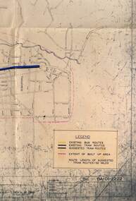
Map - Map/s, State Electricity Commission of Victoria (SECV), Ballarat bus routes, 1971
Set of five maps prepared by the SEC/Transport Regulation Board? reviewing the option for Ballarat bus routes after the closure of the Ballarat tramway system. Based on SEC drawing No. BA-D1-2222, drawn at 1" = 20 chains. Shows streets in Ballarat and Sebastopol areas. 1775.1 - tram lines shown in heavy blue lines, with grey and yellow (actual operating bus routes at the time?) routes marked out. A red dashed line defines the general built up area. 1775.2 - "PLAN A" - shows various routes in different colours for Davis, Sproule, Hick ex Whkes, Lyons, Braybrooks and Witkins services and existing tram lines. 1775.3 - "Plan B" 1775.4 - "Plan C" 1775.5 - "Plan D" 1175.6 - Plan as above, but showing existing bus routes, tram routes and suggested tram routes. Has a small sheet of paper that was clipped to the drawing. Not dated. Not known exactly the basis that these plans were drawn up on. Drawings to be scanned.trams, tramways, closure, bus routes, tram replacement, sec, transport regulation board, ballarat, tram routes -
 Archive of Vietnamese Boat People
5 grave stones of the VBP mass grave in Cherang Ruku
This 5 grave stones of the VBP mass grave in Cherang Ruku were built by the UN-HCR. As told by the local old man, Mr Lim at 80 years old, in 2010, who was in charge of burying these victims from the first day, he confirmed that there were 139 bodies buried by himself. It can accepted that because the name list of the boat was lost during sinking, the name list angraved on the stones was collected by UN HCR member by interviewing the victims who could identified victims. Furthermore the dead bodies, as told by Mr Lim, were washed ashore not in one day. The local residents could not contact to report to the UN HCR many after the accident, what they could do was that they had to quicly bury the decomposed bodies. As told by vitims of the MT065, about 2 - 3 days after the accident, they were called to the beach to identify the bodies. No way they could identify the body because it was swollen and decomposed. Face and parts of the body was eaten by fish.5 grave stones of the VBP mass grave in Cherang Ruku -
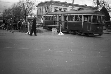 Ballarat Tramway Museum
Negative, Wal Jack, Jun. 1951
Yields information about the reconstruction of track at Hospital Corner and the way tram services were arranged and the corner itself.Negative and Digital image of the Wal Jack Ballarat Negative file of No. 35 crossing Sturt St while trackwork is being undertaken to replace diamond crossing at Hospital corner. The tram has the destination of Lydiard St North and is proceeding to Drummond St North to reverse. Based on Reg Item 5623, the work was done June 1951. In the background is H. E. Herbert's grocery shop, advertising "Rowland's" - soft drinks - see https://bih.federation.edu.au/index.php/Rowlands_Soft_Drink_Factory Reg Item 5079 - drawing of 6/1950 showing details of the crossing to be replaced. Reg Item 5340 - shows the building as well. Reg Item 5623 - has a note about the trackwork being undertaken on 19/6/1951. Reg Item 6225 - shows the new building being built during 1962. Reg Item 7720 - photocopy from Reg Item 5623 Reg Item 7721 - photocopy of the relevant page from the August 1951 issue of Electric Traction which details the event. trams, tramways, hospital corner, drummond st, sturt st, trackwork, tram 35 -
 Kew Historical Society Inc
Plan, Melbourne & Metropolitan Board of Works : Borough of Kew : Detail Plan No.1578, 1904
The Melbourne and Metropolitan Board of Works (MMBW) plans were produced from the 1890s to the 1950s. They were crucial to the design and development of Melbourne's sewerage and drainage system. The plans, at a scale of 40 feet to 1 inch (1:480), provide a detailed historical record of Melbourne streetscapes and environmental features. Each plan covers one or two street blocks (roughly six streets), showing details of buildings, including garden layouts and ownership boundaries, and features such as laneways, drains, bridges, parks, municipal boundaries and other prominent landmarks as they existed at the time each plan was produced. (Source: State Library of Victoria). This plan forms part of a large group of MMBW plans and maps that was donated to the Society by the Mr Poulter, City Engineer of the City of Kew in 1989. Within this collection, thirty-five hand-coloured plans, backed with linen, are of statewide significance as they include annotations that provide details of construction materials used in buildings in the first decade of the 20th century as well as additional information about land ownership and usage. The copies in the Public Record Office Victoria and the State Library of Victoria are monochrome versions which do not denote building materials so that the maps in this collection are invaluable and unique tools for researchers and heritage consultants. A number of the plans are not held in the collection of the State Library of Victoria so they have the additional attribute of rarity.Original survey plan, issued by the MMBW to a contractor with responsibility for constructing sewers in the area identified on the plan within the Borough of Kew. The plan was at some stage hand-coloured, possibly by the contractor, but more likely by officers working in the Engineering Department of the Borough and later Town, then City of Kew. The hand-coloured sections of buildings on the plan were used to denote masonry or brick constructions (pink), weatherboard constructions (yellow), and public buildings (grey). MMBW Plan No.1578 is significant in that it defines the extent of two private schools: Xavier College and Kew High School (now part of Trinity Grammar) by 1904. In relation to the latter, the plan clarifies which buildings the High School operated from behind the mansion ‘Molina’. Established in 1902, Trinity Grammar was to later lease and subsequently buy Molina (now ‘Merritt House’) and ‘Elsinore’ (now ‘Roberts House’). Xavier College had been established in 1872. This 1904 plan delineates the West Wing and the Great Hall (built in 1890).melbourne and metropolitan board of works, detail plans, maps - borough of kew, mmbw 1578, cartography -
 Kew Historical Society Inc
Plan, Melbourne & Metropolitan Board of Works : Borough of Kew : Detail Plan No.1590, 1905
The Melbourne and Metropolitan Board of Works (MMBW) plans were produced from the 1890s to the 1950s. They were crucial to the design and development of Melbourne's sewerage and drainage system. The plans, at a scale of 40 feet to 1 inch (1:480), provide a detailed historical record of Melbourne streetscapes and environmental features. Each plan covers one or two street blocks (roughly six streets), showing details of buildings, including garden layouts and ownership boundaries, and features such as laneways, drains, bridges, parks, municipal boundaries and other prominent landmarks as they existed at the time each plan was produced. (Source: State Library of Victoria)This plan forms part of a large group of MMBW plans and maps that was donated to the Society by the Mr Poulter, City Engineer of the City of Kew in 1989. Within this collection, thirty-five hand-coloured plans, backed with linen, are of statewide significance as they include annotations that provide details of construction materials used in buildings in the first decade of the 20th century as well as additional information about land ownership and usage. The copies in the Public Record Office Victoria and the State Library of Victoria are monochrome versions which do not denote building materials so that the maps in this collection are invaluable and unique tools for researchers and heritage consultants. A number of the plans are not held in the collection of the State Library of Victoria so they have the additional attribute of rarity.Original survey plan, issued by the MMBW to a contractor with responsibility for constructing sewers in the area identified on the plan within the Borough of Kew. The plan was at some stage hand-coloured, possibly by the contractor, but more likely by officers working in the Engineering Department of the Borough and later Town, then City of Kew. The hand-coloured sections of buildings on the plan were used to denote masonry or brick constructions (pink), weatherboard constructions (yellow), and public buildings (grey). Surveyed by the Board of Works in 1903 and published in 1904, Plan No.1590 shows development north of Cotham Road. While this plan includes built structures in Mary Street, Cotham Road, High Street, Park Hill Road, Kent Street, Ridgeway Avenue, and Ermington Lane (now Ermington Place), only part of this section was notated and coloured in this contractor’s copy. Numerous houses, large and small are named on the plan: ‘Cholula’, ‘Belper’, ‘The Uplands’, ‘Spring Grove’ facing Cotham Road; ‘Marion’ facing Kent Street; and ‘Kia Ora’ facing Ridgeway Avenue.melbourne and metropolitan board of works, detail plans, mmbw 1590, survey plans - borough of kew, cartography -
 Melbourne Tram Museum
Newspaper, The Age, "Trackless and with rubber wheels, it may be our next generation trams", 2/05/2021 12:00:00 AM
Newspaper clipping titled: “Trackless and with rubber wheels, it may be our next generation trams” by Timna Jacks Newspaper clipping from the Age 02/05/2021 Rubber wheels, electric batteries and no overhead wires could be the future for Melbourne’s trams. By 2025, 100 new trams will be designed and built due to a $1.5 billion government injection to fund 100 ‘‘next-generation trams’’, replacing A and Z-Class trams. Two manufacturers have been shortlisted to design and build the trams: French rail manufacturer Alstom and a joint venture comprising Spanish rail maker CAF and UGL. At 25 metres long – about eight metres shorter than the newest E-Class trams – the trams will carry 150 passengers, fewer than the E-Class, which carry 210 people. Despite the smaller size, seating will remain proportionally comparable with the E-Class, with 48 people or a third of passengers getting a seat on the new fleet. The new fleet will be the first in Melbourne to be partly powered by on-board batteries.trams, tramways, yarra trams, keolis downer, caf, rolling stock, e class, z class, a class, ugl, tramcar acquisition, tramcar design, tramcar manufacture -
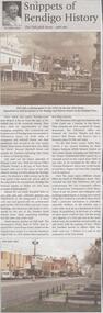 Bendigo Historical Society Inc.
Newspaper - JENNY FOLEY COLLECTION: SNIPPETS OF BENDIGO
BHS CollectionBendigo Weekly - Snippets of Bendigo History, The Pall Mall story, part one - By Edith Lunn. Pall Mall was the vision of Richard Larritt who, from the Survey Office (Dudley House) at the top of View Street created order out of the chaos of the early alluvial mining activities along the Bendigo creek. Much history attaches to Pall Mall. The Freemasons' hotel, built in 1858, later renamed the Court house hotel, stands on the Mundy Street corner. In 1902 Sidney Myer opened his first shop close by. Bill Hampton had a grocery business and Colin Creek was a butcher in this block. On the Bull Street corner, Taylor Bros erected a two storied building for their drapery business. Crossing over Bull Street the former Commercial hotel stood on the corner from 1868. Many different shops filled the block to Williamson Street, they included Mr and Mrs Pedersen's café, the Gas Company's office, Fontawayne's frock shop, Hume and Iser, Doug Pain jeweller. The clip is in a folder.newspaper, bendigo, bendigo weekly -
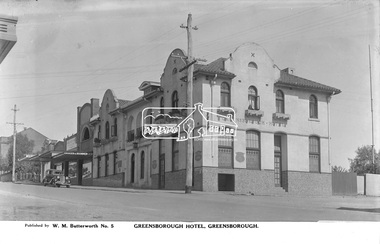 Eltham District Historical Society Inc
Photograph, The Rose Stereograph Company, Greensborough Hotel, Greensborough, c.1938
View looking west across Main Road towards the Greensborough Hotel built 1925 and adjoining shops. A Ford Model Y 4dr Saloon Registration 83-961 is parked in Main Road outside the shops. Visible are Ryan Bros Butchers, State Electricity Commission of Victoria, Dispensing Chemist, Ray Trinham Grocer & Ironmonger Ryan Bros Butchers sold their shop to new owners in December 1938. This glass plate negative was used to manufacture postcards (1:1 printing) for commercial sale by the Rose Sterograph Company and its subsidiaries. George Rose founded the Rose Stereograph Company in 1880 and was joined by Herbert (Bert) Cutts in the early 20th Century. The pair formed a lifetime working partnership and strong personal friendship. Assisted by George’s two sons, Herbert George and Walter, and later by Neil Cutts, the Rose Stereograph Company continued its operations for more than 140 years. The company was initially built on stereographs, but as cinema took over and stereographs fell out of fashion, the Rose Stereograph Company developed Australia’s first commercially viable photographic postcard business. Specialising in postcards of iconic historical moments and significant landmarks, The Rose Stereograph Company became a staple of the Australian travel industry.This remarkable collection of glass plate negatives, transparencies, and postcards – arguably Australia’s most significant photography collection outside of public hands – has been passed down through the generations, surviving war, relocation, and the harsh Victorian climate. The historic Rose Stereograph collection is the culmination of George Rose’s dream of capturing and preserving precious moments in time and remains the legacy of the Rose and Cutts families. It is with great sadness that the Cutts family says goodbye to a collection that spans five generations and 140 years. The Cutts family understands that for these historically important pieces to rest with one family is to deny others the pleasure of their custodianship.Glass Plate Negative Size: 9 x 13.9 cmGreensborough Hotel, Greensborough, Published by W. M. Butterworth No. 5postcard, travel, rose stereograph company, glass plate negative, greensborough, main road, w. m. butterworth, greensborough hotel, ford model y 4 dr saloon, dispensing chemist, grocer and ironmonger, ray trinham, ryan bros butchers, state electricity commission of victoria, peter and elizabeth pidgeon collection -
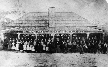 Eltham District Historical Society Inc
Negative - Photograph, Eltham State School No. 209, Dalton Street, Eltham, c.1990 (1864)
Negative copy of copy by Yeoman and Co. of original c.1864 photograph. The first Eltham State School building with school group. David Clarke (Head Teacher) and his sister, Catherine are standing in the centre of the group. Built with stone walls and wooden shingles on the roof. This was the first State School building which was built in 1856 and replaced with a new building in 1875 after the stone walls collapsed outwards. Published in Nillumbik Maii; Edition 20, 13 Sep Harry Gilham notes: - Believed to be the National School at Eltham on the Dalton Street site 1857-1874 - £220 cost; £110 National Board and £110 local patrons - 40' (38'6") x 16' x 10' walls - David Clark Head Teacher and Catherine Clark, Sewing Mistress - Its building materials came from the western edge of the site where sandstone removed is still evident and children are protected from the site by the fences of 1994 of wire mesh and palings beside the residence - School had 7' verandah added in 1861 - Clarks used half the building as a residence from 1857-1866 when enrollments required use of the whole building - The Clarks moved to then Shoestring residence in Metery Road adjacent to the end of the school ovalRoll of 35mm Black and White negative film, 3 strips, (2 of 14 frames)Film - Agfa Ortho 25catherine clarke, class photo, dalton street, david george clark, eltham, eltham state school no. 209, school group, national school -
 Federation University Historical Collection
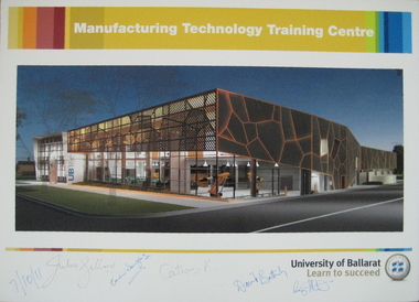
Photograph - Poster, University of Ballarat Manufacturing Technology Training Centre poster signed by Prime Minister Julia Gillard, 07/10/2011 (approx 11.15am)
The new Manufacturing Technology Training Centre (MTTC), a part of the proposed Building Construction Training Centre (BCTC), will be a purpose-built, stand-alone, fully fitted-out industry-standard facility. This new space will accommodate current course provision along with specialist training spaces for developing skill requirements in manufacturing technology such as robotics, mechatronics, engineering and industrial automation. Project funding was provided by the Education Investment Fund from the Australian Government Department of Education, Employment and Workplace Relations. The project budget is $18.09m, and the resulting building will have a floor space of 4,755m2. The Manufacturing Technology Training Centre is being built in conjunction with the Technical Education Centre (UBTec). While the buildings will have separate street identities the buildings will be joined with shared amenities areas. UBTec will provide a facility including individual learning spaces, learning studios, administration/office space, circulation, open plan learning space, staff common areas, computer rooms, meeting rooms, staff work areas and kitchen areas as well as car parking and site-wide amenities. While the buildings will have separate street identities the buildings will be joined with shared amenities areas. Funding for the UBTec component of the building is provided by Maintaining the Advantage: Skilled Victorians from the Victorian State Government. A colour poster prepared for the 'turning of the sod' at the site of the proposed University of Ballarat Manufacturing Technology Training Centre (MTTC), Grant Street, Ballarat. The poster was signed on Friday 7 October 2011 at about 11:15 am at the Building Construction Training Centre (BCTC), Grant Street, Ballarat by: Hon. Julia Gillard MP Hon. Catherine King MP (Ballarat ) Prof. David Battersby, Vice Chancellor, University of Ballarat Mayor, Cr Craig Fletcher, Mayor of the City of Ballarat appointed in December 2010 Mrs. Karen Douglas, Chair University of Ballarat Building & Infrastructure Committee The poster is signed by the Prime Minister of Australia, the Hon. Julia Gillard MP; Karen Douglas; the Hon. Catherine King MP (Ballarat ); Prof. David Battersby (Vice Chancellor); Craig Fletcher (Mayor, City of Ballarat)university of ballarat, david battersby, julia gillard, prime minister, catherine king, ubtec, karen douglas, manufacturing technology training centre, grant street, architecural feature -
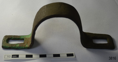 Flagstaff Hill Maritime Museum and Village
Functional object - Bracket
This metal bracket is part of the wooden barque, the Grange, built in 1840. The bracket was recovered from the shipwreck of the Grange in around 1968, 110 years after the Grange was wrecked (see below for further details on the Grange). It is part of the John Chance Collection. THE GRANGE, 1840-1858- The wooden barque ’Grange’ was a three-masted ship built in Scotland in 1840 for international and coastal trade. On March 22, 1858, the Grange set sail from Melbourne under Captain A. Alexander, carrying a cargo of ballast. The barque had left the Heads of Phillip Bay and was heading west along the Victorian coast towards Cape Otway. The ship struck Little Haley’s Reef at Apollo Bay due to a navigational error and was stuck on the rocks. The crew left the ship carrying whatever they could onto the beach. Eventually, the remains of the hull, sails and fittings were salvaged before the wreck of the Grange broke up about a month later. About 110 years later, in 1968, the wreck of the Grange was found by divers from the Underwater Explorers Club of Victoria. They were amazed to find a unique, six to nine pound carronade (type of small cannon) and a cannonball on the site. There have been no other similar carronades recorded. In that same year the anchor of the Grange was recovered by diver John Chance and Mal Brown. The bracket is significant historically as an example of hardware used when building wooden ships in the early to mid-19th century. The bracket is historically significant as an example of the work and trade of blacksmith. The bracket also has significant as it was recovered by John Chance, a diver from the wreck of the Grange in the 1968. Items that come from several wrecks along Victoria's coast have since been donated to the Flagstaff Hill Maritime Village’s museum collection by his family, illustrating this item’s level of historical value. The bracket is historically significant for its association with the 1840s wooden barque, the Grange. The Grange is an historical example of a Scottish built vessel used for international and coastal trader of both cargo and passengers in the mid-19th century. The Grange is an example of an early ship, designed with a wooden hull. It is significant as a ship still available to divers along the south coast of Victoria, for research and education purposes. The Grange is an example of a mid-19th century vessel that carried a weapon of defence onboard.Bracket, brass, U shaped with rectangular flat ends. Both ends have a formed rectangular hole in them; the hole has rounded corners. The metal has corroded in places and has green concretion.flagstaff hill, warrnambool, flagstaff hill maritime museum, maritime museum, shipwreck coast, flagstaff hill maritime village, great ocean road, west coast trader, apollo bay, mid-19th century shipwreck, the grange, scottish barque, little henty reef, captain a alexander, underwater explorers club of victoria, 1840s carronade, vhr 5297, coastal trader, wooden shipwreck, john chance, wooden ship, ship fitting, bracket -
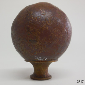 Flagstaff Hill Maritime Museum and Village
Decorative object - Sphere
This metal sphere is part of the wooden barque, the Grange, built in 1840. The sphere was recovered from the shipwreck of the Grange in around 1968, 110 years after the Grange was wrecked (see below for further details on the Grange). It is part of the John Chance Collection. THE GRANGE, 1840-1858- The wooden barque ’Grange’ was a three-masted ship built in Scotland in 1840 for international and coastal trade. On March 22, 1858, the Grange set sail from Melbourne under Captain A. Alexander, carrying a cargo of ballast. The barque had left the Heads of Phillip Bay and was heading west along the Victorian coast towards Cape Otway. The ship struck Little Haley’s Reef at Apollo Bay due to a navigational error and was stuck on the rocks. The crew left the ship carrying whatever they could onto the beach. Eventually, the remains of the hull, sails and fittings were salvaged before the wreck of the Grange broke up about a month later. About 110 years later, in 1968, the wreck of the Grange was found by divers from the Underwater Explorers Club of Victoria. They were amazed to find a unique, six to nine pound carronade (type of small cannon) and a cannonball on the site. There have been no other similar carronades recorded. In that same year the anchor of the Grange was recovered by diver John Chance and Mal Brown. The sphere is significant historically as an example of hardware used when building wooden ships in the early to mid-19th century. The sphere is historically significant as an example of the work and trade of blacksmith. The sphere also has significant as it was recovered by John Chance, a diver from the wreck of the Grange in the 1968. Items that come from several wrecks along Victoria's coast have since been donated to the Flagstaff Hill Maritime Village’s museum collection by his family, illustrating this item’s level of historical value. The sphere is historically significant for its association with the 1840s wooden barque, the Grange. The Grange is an historical example of a Scottish built vessel used for international and coastal trader of both cargo and passengers in the mid-19th century. The Grange is an example of an early ship, designed with a wooden hull. It is significant as a ship still available to divers along the south coast of Victoria, for research and education purposes. The Grange is an example of a mid-19th century vessel that carried a weapon of defence onboard. Sphere; thin hollow copper, various shades of brown, dimpled or hammered surface with a sheen, no joins. Base has a small hole and is fitted with a hollow, cylindrical brass collar. The collar had a rim on top, inward curving sides and a narrower rim on the bottom. The sphere looks similar to a bed post knob.flagstaff hill, warrnambool, flagstaff hill maritime museum, maritime museum, shipwreck coast, flagstaff hill maritime village, great ocean road, west coast trader, apollo bay, mid-19th century shipwreck, the grange, scottish barque, little henty reef, captain a alexander, underwater explorers club of victoria, 1840s carronade, vhr 5297, coastal trader, wooden shipwreck, john chance, wooden ship, ship fitting, sphere, knob, bed knob, post decoration -
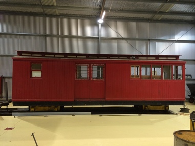 Puffing Billy Railway
6NBC, Combined Passenger and Guards Van. 2'6" Gauge, 1906
NBC COMBINED SECOND-CLASS PASSENGER CAR AND GUARD'S VAN. Six cars, numbered 1-6, were built during 1898-1905 and originally classed NBDBD. The repeat of the 'BD' lettering in the classification signified that the vehicle was carried on bogie wheels. At the time the letter D was the letter code for Brakevans / Guard's Vans, but this was changed to C when the double-letter code was simplified in 1910. The letter C now being used to describe that a guards compartment was included in the bogie vehicle. On the narrow gauge, the vehicle numbers were retained. A final NBC numbered 7 was added to the fleet in 1910 Between 1926 and 1929 the cars were converted to autocoupler operation. 6NBC Used on the Upper Ferntree Gully, Wangaratta and Colac narrow gauge railways. Withdrawn from service 1951 and used as a workman's hut at Pakenham. Purchased by the Puffing Billy Preservation Society and moved to Menzies Creek in 1959 Utilised as a ticket office and kiosk for the Museum from 1965 to 2010. Service History : NBDBD 6.VA - 26/ 5/1905 NWS Built new - circa 1910 - To NBC 6.VA - *NBC 6.VA - circa 1910 - Reference Photo SL20 p25 /12/1927 - Modified AC Malco BO 19/ 1/1951 - Scrapped Historic - Victorian Railways - Narrow Gauge Rolling Stock - NBC 2nd Class Passenger Car and Guard's VanTimber body (Painted) Steel Chassis (painted) Brass Fittings (Raw) Steel Fittings (Painted)6NBCpuffing billy railway, pbr, 6nbc - victorian railways nbc class combined passenger and guards van. 2'6" gauge -
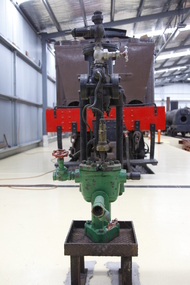 Puffing Billy Railway
Steam Driven Weir Pump, 1900s
G. and J. Weir of Holm Foundry, Cathcart, Glasgow and now known as the Weir Group. The company was established in 1871 as an engineering firm by two brothers, George and James Weir, founding G. & J. Weir Ltd. The Weir brothers produced numerous groundbreaking inventions in pumping equipment, primarily for the Clyde shipyards and the steam ships built there. These pumps became extremely well known for their use as boiler feedwater pumps, and for ship's auxiliary equipment such as evaporators. Under W D Weir, the company turned to producing munitions and war material in the First World War. As well as shells, they manufactured aircraft including the Royal Aircraft Factory F.E.2 fighter and bomber. James George Weir (aviator, son of James Galloway Weir) a director of the company formed the Cierva Autogiro Company. G & J Weir would be a financial supporter of the company during its existence. In 1943, they provided the finances for the construction of the W.9, an experimental helicopter, to Air Ministry requirements. It was first listed on the London Stock Exchange in 1946. Double-acting Weir steam pumps were virtually standard fitment on British-built steamships, being used for pumping water, fuel, air and much else well into the 1950s, as well as being used on other ships worldwide. Historic - Double-acting Weir steam pumpSteam Driven Pump made of iron & steel puffing billy, weir pump, weir, steam driven pump -
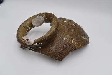 Geelong Naval and Maritime Museum
Ceramic - Pot Fragment
The fragments of pot were found in 20 meters of water off of the South Channel Light, Port Phillip Bay. They are believed to be from the ship 'Hurricane' that sank in the vicinity on April 22,1864. The Hurricane was a three-masted iron ship, weighing 1198/979 tons. Built on the Clyde, Scotland in 1853. Lbd 214.9 x 30.7 x 20 ft. It was one of the first large iron sailing ships built for the Australian trade during the gold rush, and one of the fastest clippers on the Australian run. Her maiden voyage from Glasgow to Melbourne with 256 passengers took eighty-seven days, and the return to London eighty-three days. In 1856 she was converted to an auxiliary screw vessel and continued in the Australian trade until lost. Under Captain D.H. Johnston (former master of the Lightning), inward bound from Liverpool with 2000 tons of general cargo and 19 passengers, grazed a rock entering Port Phillip, sank off Arthurs seat, 21 April 1869. Passengers and crew transferred to the tug Titan. The wreck was relatively intact until the late 1960s, when it was blasted by Ports and Harbours engineers who considered it to be a navigational hazard, spreading wreckage over a wide area. Despite this, the stern of the ship still stands about three metres above the sand. The wreck of the "Hurricane" in Port Phillip Bay and the accompanying story of the nearby lighthouse, the South Channel Pile Light, tell the story of early shipping within Port Phillip Bay, pre federation. 3 pieces of encrusted pot fragment all roughly A5 paper sizeshipwreck, port phillip bay, ship hurricane, south channel light -
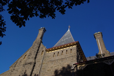 Ballarat Heritage Services
Photograph - Image - Colour, Clare Gervasoni, Bishop's Palace Ballarat Featuring Chimneys and Roof Line, Ballarat, 2014, 23/02/2014
Bishops Palace was built in 1877 as the home for the first Catholic Bishop of Ballarat. Designed by Melbourne architect, Joseph Reed, of Reed and Barnes, it was built by George Broom at a cost of £6,000. Reed and Barnes also designed Melbourne’s State Library, Ripponlea Estate and the Melbourne Royal Exhibition Building. The original heritage-listed gold lead stencilled paintwork that can be seen in the front entry and on the staircase walls at Bishops Palace was replicated in the Royal Exhibition Building. The original property was 140 squares set on 11 acres of gardens and took up an entire block of Sturt Street. This was on scale with the importance of Ballarat as a gold-mining centre at the time. Bishop's Palace is of architectural, aesthetic and historical significance to the State of Victoria. The two-storey bluestone mansion is an impressive example of 19th-century Gothic architecture with an unusual design. It retains many of its original features, including lead stencilled paintwork, cornices, ceiling roses, fixtures and fittings. Since sold by the Catholic Church the Bishops Palace has undergone a number of transformations in its lifetime, from the home of the first Bishop to a private residence, and today, as a luxurious accommodation, wedding and events venue. The grounds were subdivided over the years, and the property is now surrounded by four of the original 11 acres of gardens. It opened its doors to the public in 2019.Colour image of the bluestone Bishop's Palace, and it's cast iron lace.architecture, garden, bishop's palace, cast iron lace, cast iron, catholic church