Showing 6308 items
matching housing
-
 Eltham District Historical Society Inc
Slide, McCarthy Grove, Montmorency looking west near No. 27, c.Oct. 1980
One of a series of images of roads and infrastructure taken by Eltham Shire Council Planning and Engineering officers. They provide perspective of the changes in housing styles and road development that began sweeping in from the mid 1970s with increasing urbanisation of what was once more outlying suburbs and regions.35 mm colour positive transparency Mount - Kodak Kodachrome CardProcessed Oct 1980houses, infrastructure, mccarthy grove, montmorency, roads -
 Eltham District Historical Society Inc
Slide, McCarthy Grove, Montmorency looking east towards Reichelt Avenue, near no. 27, c.Oct. 1980
One of a series of images of roads and infrastructure taken by Eltham Shire Council Planning and Engineering officers. They provide perspective of the changes in housing styles and road development that began sweeping in from the mid 1970s with increasing urbanisation of what was once more outlying suburbs and regions.35 mm colour positive transparency Mount - Kodak Kodachrome CardProcessed Oct 1980houses, infrastructure, mccarthy grove, montmorency, roads -
 Eltham District Historical Society Inc
Slide, Quinn Estate, McCarthy Grove ext. driveway, Montmorency, near no. 31, c.Oct. 1980
One of a series of images of roads and infrastructure taken by Eltham Shire Council Planning and Engineering officers. They provide perspective of the changes in housing styles and road development that began sweeping in from the mid 1970s with increasing urbanisation of what was once more outlying suburbs and regions.35 mm colour positive transparency Mount - Kodak Kodachrome CardProcessed Oct 1980houses, infrastructure, mccarthy grove, montmorency, roads -
 Eltham District Historical Society Inc
Slide, Looking towards 99 Buena Vista Drive, Montmorency, c.Oct. 1980
One of a series of images of roads and infrastructure taken by Eltham Shire Council Planning and Engineering officers. They provide perspective of the changes in housing styles and road development that began sweeping in from the mid 1970s with increasing urbanisation of what was once more outlying suburbs and regions.35 mm colour positive transparency Mount - Kodak Kodachrome CardProcessed Oct 1980houses, infrastructure, mccarthy grove, montmorency, roads -
 Whitehorse Historical Society Inc.
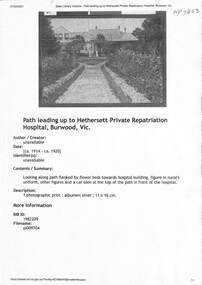
Document - Various including photos, newspaper items, Hethersett Private Repatriation Hospital, Burwood, 1866 - 1943
Between 1915 - 1917 Dr Ramsay Mailer and members of his family ran the 30 bed Hethersett Voluntary Military Hospital in Burwood for5 returned shell shocked and fatigued soldiers at his own expense. This property became part of the Presbyterian Ladies College in1939.A4 Print outs from blogspot, Trove (SLV), and newspaper obituariesnon-fictionBetween 1915 - 1917 Dr Ramsay Mailer and members of his family ran the 30 bed Hethersett Voluntary Military Hospital in Burwood for5 returned shell shocked and fatigued soldiers at his own expense. This property became part of the Presbyterian Ladies College in1939. mailer ramsay dr, world war 1914-1918, housing reform 1920s, camp mailer, hospitals, repatriation care -
 Sunbury Family History and Heritage Society Inc.
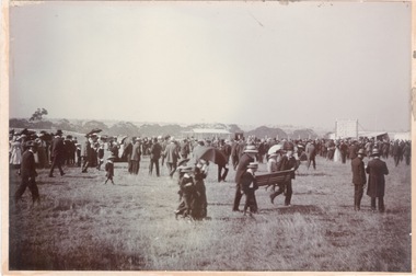
Photograph, Sunbury Racecourse
The photograph was taken at a Sunbury Race meeting, when a sudden shower of rain caused the spectators to run for cover. Sunbury Race Course was situated along Racecourse Road about 2kms from the railway station. The land has been sold and it is now a housing estate. The race meetings in Sunbury were well attended with special trains running from Melbourne on race days.A noon-digital sepia photograph mounted on cardboard of a crowd of people caught in a sudden shower of rain and running for shelter at a race meeting.sunbury race meetings, racecourse road, races, stud farms -
 Bendigo Military Museum
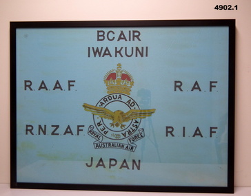
Banner - BCOF BANNERS, FRAMED, c1946 - Frame 2022
1. "I.W.A. KUNI" - City in Japan. 2. " B.C.O.F." - Japan 1946-48. British Commonwealth Occupation Forces (Japan).1. Banner - framed cotton fabric, light blue background with screen printing in black colour letters and centre unit insignia black, yellow and red colours. 2. Banner - framed cotton fabric, white background with screen printing in black colour letters and centre unit insignia red, yellow and blue colours. 1. & 2. Frames - timber, black colour paint, glass front, timber housing.Screen printing - black ink. 1. "BCAIR/IWA KUNI/ R.A.A.F./R.A.F./ R.N.2.A.F./R.I.A.F./JAPAN " Unit insignia 'ROYAL AUSTRALIAN AIR FORCE' 2. " R.A.N./H.M.A. SHIPS/ B.C.O.F./ AUSTRALIA - JAPAN/1946-1948"military, ww2, japan, banners -
 Bendigo Historical Society Inc.
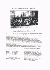
Document - LONG GULLY HISTORY GROUP COLLECTION: LONG GULLY HISTORY GROUP
Page advertising The Long Gully History Group which meets every Thursday from 1 - 3 pm. They aim to write a book specifically on Long Gully and have it published. The is an invitation for people to come during Housing Week. House Hours and After School Program are mentioned. Also mentioned is the Long Gully Aquatic Centre. A black and white photo of the Long Gully State School Class 1 & 2 is attached.bendigo, history, long gully history group, the long gully history group - long gully history group, long gully state school class 1 & 2, long gully swimming pool -
 Ballarat Tramway Museum
Newspaper, The Courier Ballarat, "Tram depot site to be auctioned", 5/05/1972 12:00:00 AM
Newspaper clipping from The Courier, Ballarat, dated Friday 5/5/1972 titled "Tram depot site to be auctioned". Item advising that the SEC Tram depot is to be sold in one lot, following an announcement in Parliament by Mr. Tom Evans MLA and that the decision to auction the site replaces the SEC proposal for an architect designed housing scheme. One of a large group of newspaper cuttings from John Bainbridge, 7/4/02.sec depot, sale of sec depot -
 Maldon Vintage Machinery Museum Inc
Motor Mower, Maker's name "Charles H Pugh"
Green painted cylindrical lawn mower with rear roller, pull start and no catcher. Regal coat of arms on front housing signifying maker is official motor mower supplier to the Queen. Rectangular petrol tank mounted between the handles above the engine. Small wooden roller in two parts on front. Pale grey plastic cover on starter mechanism. Height adjustment on front roller. Engine controls on right handle.Possibly "Eureka" model.machinery, cylinder motor mower -
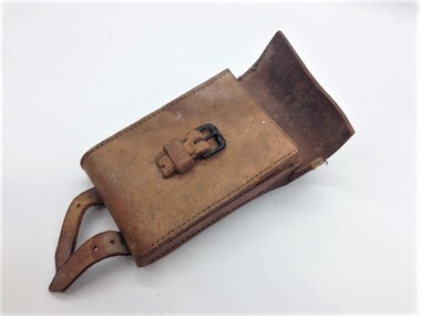 Montmorency/Eltham RSL Sub Branch
Weapon - Case, Leather, for Vickers Machine Gun Clinometer, Clinometer for Vickers Gun, 1942
Used for WWIIUsed for WWIILight brown coloured stitched leather case with rounded ends for housing a Clinometer, brass and steel, for a Vickers machine gun. The rear of the case has two short leather straps and steel buckles, attached with a metal rivet. The strap has 6 holes for attachment to the buckle. The front of the case has a steel buckle attached by a small leather strap attached by stitching. The top lid of the case is missing a leather strap.SIGHT CLINOMETER SPARE Q.F 13 & 18 PR. M. H. & Co. R.C.D. IL 1942 -
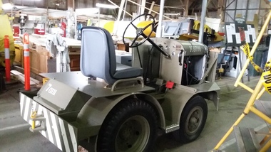 B-24 Liberator Memorial Restoration Australia Inc
Vehicle, Mercury Aircraft Tug
Motorised tugs were used by ground crew to move aircraft on the ground.This tug is of historical significance to the B24-LiberatorMotorised Aircraft TugMERCURY TRUCK & TRACTOR CO LTD GLOUCESTER ENGLAND-Embossed figurehead of Mercury on front. The MERCURY TRUCK & TRACTOR CO GLOUCESTER , For Spare parts quote chassis no.4962. Tyre Pressure LBS.Per Sq Inch - Front 70 Rear 45 ON plate on Dashboard MORRIS COMMERCIAL embossed on gearbox housing. MT & T embossed on either side of radiator. -
 City of Kingston
Photograph - Black and white, 20 December 1945
Cheltenham is a suburb in the City of Kingston that was originally established as a rural market gardening community. The area is bordered by Highett, Mentone and Heatherton. The market gardens, farms and paddocks have gradually been sub-divided into housing and industrial estates. The Southland shopping centre is a major feature of the area.Cheltenham was established as a rural market gardening community. The Le Page family lived in Cheltenham since 1854 when Nicholas Le Page, a tailor from the Channel Island of Guernsey, bought two acres of land on Chesterville Road near Bernard Street to establish a market garden. Over the years the Le Pages purchased more land in the area. In 1875-76 Nicholas' son Frank and his wife Mary built 'Daphne Cottage' near the corner of Bernard and Wilson Streets. n the 1940s Frank's son, Everest Le Page, bought five more lots of land in Chesterville Road from the Tuck family. The Le Pages grazed horses, ponies and cows on this land, and grew pumpkins, carrots, parsnips, onions, potatoes and cabbages. Many buildings and locations within in Cheltenham commemorate the Le Page family's contribution to the Cheltenham community.Aerial photograph taken in 1945 of the Cheltenham district within the City of Kingston. The image includes Chesterville Road, the future site of Turner Road pool (now Waves) and Highett Reserve, (top left), Jellicoe Street, Argus Street, Bernard Street, Wilson Street, the Methodist Children Homes (now Southland), McIvor Street, Goulburn Street, Nepean Highway, Jamieson Street and Barker Street (bottom left), market gardens and paddocks. In the top centre of the image, "Daphne Cottage", the home of Frank T. Le Page is visible on the corner of Bernard and Wilson Streets. Much of the land depicted in this image was owned by the Le Page family. This image is possibly from the collection of aerial photographs commissioned by the Department of Crown Lands and Survey and taken by Adastra Airways.Black and white ink: 57250 White print: VIC-170 57250 20.12.45 Run 6 PROJ. No. 5 MELB. METROP AREA Black type 10200 FTS 30' LENS 20.12.45cheltenham, market gardens, industry, le page family -
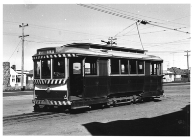 Ballarat Tramway Museum
Photograph - Ballarat tram 14 at Sebastopol, late 1960s
The photograph shows Ballarat tram No. 14 at the Sebastopol terminus, late 1960s or early 1970s. The tram has a destination of Lydiard St North and a "Pay as you Enter" sign by the open door. In the background are the Houses built by the Housing Commission. Photographer unknown. Two copies held.Yields information about tram 14 at the Sebastopol terminus.Black and white print - plain back.tramcars, tramways, tram 14, sebastopol, signs, pay as you enter -
Federation University Historical Collection
Document - Document - Letter, Ballarat Junior Technical School: Letter from Mr Garner, Head Master, to Mr R Watson, Geelong, 1953
Letter from Mr Garner to Mr R Watson congratulating him on his promotion back to Ballarat Junior Technical School. His former colleagues hold him in high regard. The housing situation is difficult at present but he will continue to make enguiries and forward information to him.. Yellow paper typedballarat junior technical school, l garnar, junior technical certificate, head master, mr r watson, promotion back to bjts, housing situation enquiries -
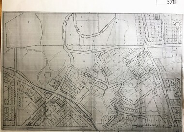 Greensborough Historical Society
Map, City of Heidelberg, Subdivision plan of Greensborough, 1965c
Subdivision plan of Greensborough including Briar Hill and Greenhills. Supplied by Bill Cecil whose parents owned the Greensborough Post Office and it is assumed that these maps were used by Bill (who delivered the post on horseback) to keep up to date with the growing number of new streets and housing in Greensborough.Copies of subdivision plan for Greensboroughgreensborough, briar hill, greenhills -
City of Kingston
Photograph - Black and white, 5 January 1984
Moorabbin, Cheltenham and Highett are suburbs in the City of Kingston with a diverse mix of development and zoning. The market gardens, farms and paddocks have gradually been sub-divided into housing and industrial estates and associated infrastructure such as schools and shopping facilities. The area includes many parks, reserves and golf courses.This aerial image covers a diverse section of the City of Kingston, taking in the suburbs of Cheltenham, Moorabbin, Beaumaris and Highett. By 1984, the market gardens of the district have been replaced by housing and factories. The Gas and Fuel state-of-the-art Scientific Services Department is visible on Nepean Highway Highett. The CSIRO Highett site can also be seen. Both sites have now been demolished and have undergone remediation. The Southland site is visible and yet to be redeveloped by Westfield. This image portrays the diversity of development in the City of Kingston with a mixture of green spaces, housing and commercial and industrial features.Aerial photograph of Cheltenham, Beaumaris, Moorabbin and Highett within the City of Kingston. The area depicted in the 1984 aerial view includes Eden Street and Edward Street, Cheltenham (top left), Weatherall Road and Reserve Road, Cheltenham/Beaumaris (top right), Turner Road and Chesterville Road, Moorabbin (bottom left), Nepean Highway (left section), Graham Road and Middleton Street, Highett (bottom right). A large section of this image includes Cheltenham Park and Victoria Golf Club.White text: 3831-219 Lens information [indecipherable] RINGWOOD M/S 7922-3 RUN 15 Clockface image 5,300' ASL VIC DLS© 5-1-84cheltenham, highett, industrialisation, urbanisation, moorabbin, beaumaris -
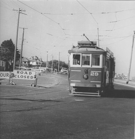 Melbourne Tram Museum
Photograph - VR 29 Baths Terminus, Jim Seletto, circa January 1958
The photograph shows VR tram No.29 with the destination St Kilda Rly near the Middle Brighton crossover. Road work signs indicate road closure and detours. In the background track excavation may be underway. The beach front and residential housing are also visible. Photo by J Seletto.Yields information about the last VR tramway and its progressive closure.Black and White photograph with photographer's notes on rearIn red biro on rear: 'VR Dreadailnought [sic] 29 baths Terminus Jan 58? D Print, JSE8'trams, middle brighton, vr trams, tram 29, closure -
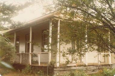 Phillip Island and District Historical Society Inc.
Photograph, 1880's
San Remo house built by Charles Grayden 1880?? Possibly Miss Elms' house.coloured print - side view of weatherboard painted white/cream. Verandah with slender square posts - framed by Pine Tree on left and small leafed tree on right.local history, photography, san remo, local area development by europeans, housing, coloured photograph, commercial development san remo, domestic development -
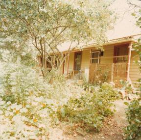 Phillip Island and District Historical Society Inc.
Photograph, 1978/9
The house was built by William Richardson, father of Charlie Richardson. Situated on Beach Road, opposite the Rhyll Jetty. Probably built in the 1870s.Coloured photograph showing home of Charlie Richardson, Rhyll.local history, photographs, buildings - historical, housing, coloured photograph, john cook, phillip island, charlie richardson -
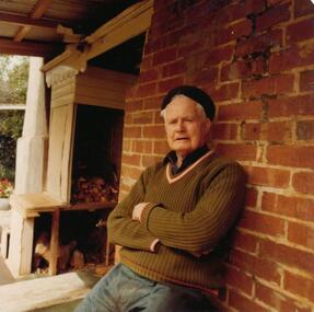 Phillip Island and District Historical Society Inc.
Photograph, 1978/9
Charlie Richardson was the son of William Richardson and grandson of Joseph Richardson who arrived on Phillip Island in 1868. Mr Charlie Richardson was for many years the Mate of the Rhyll-Stony point Ferry. He grew up at Rhyll and attended the Rhyll State School with his brothers and sisters.Coloured photograph showing Charlie Richardson on verandah of his home at Rhyll, Phillip Island.local history, photographs, buildings - historical, housing, coloured photograph, john cook, phillip island, charlie richardson -
 Phillip Island and District Historical Society Inc.
Photograph, 1978/9
Charlie Richardson was the son of William Richardson and grandson of Joseph Richardson who arrived on Phillip Island in 1868. The house at Rhyll was built by William Richardson who went to live at Rhyll in 1876 on land, owned by his father, opposite the Jetty.Coloured photograph showing the Kitchen of Mr Charlie Richardson's home, opposite the Rhyll Jetty.local history, photographs, buildings - historical, housing, coloured photograph, john cook, phillip island, charlie richardson -
 Phillip Island and District Historical Society Inc.
Photograph, 1978/9
The house was built by William Richardson who went to live at Rhyll in 1876. His father, Joseph, owned the land. Joseph had arrived on Phillip Island in 1868 when the first land sale took place. Charlie, William's son, grew up in the house with his parents, brothers and sisters.Coloured photograph showing the kitchen at William Richardson's house in Rhyll.local history, photographs, buildings - historical, housing, coloured photograph, john cook, phillip island, charlie richardson -
 Phillip Island and District Historical Society Inc.
Photograph, 1978/9
The home of Captain Loch at Rhyll was built in the 1860s from timber from deserted cottages on the Island, one of which Capt. Loch lived in when he first came to Phillip Island about 1850.Coloured photograph showing the house of Captain Lock at Rhylllocal history, photographs, buildings - historical, housing, coloured photograph, john cook, phillip island, cpt lock -
 Phillip Island and District Historical Society Inc.
Photograph, 1978/9
"Heath Hill" was built by the McIlwraith brothers in 1872. They were one of the early settlers on the Island.Coloured photograph showing "Heath Hill" which was the house of the McIlwraith family on the Rhyll-Newhaven Road.local history, photographs, buildings - historical, housing, coloured photograph, john cook, phillip island, mcilwraith homestead -
 Phillip Island and District Historical Society Inc.
Photograph, 1978/79
Stradbroke House was once run by W Smith - now (1979) owned by C CarterColoured photograph of Stradbroke House.local history, photographs, buildings - historical, housing, coloured photograph, john cook, phillip island, stradbroke house -
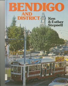 Bendigo Historical Society Inc.
Book - BENDIGO AND DISTRICT, 1976
Bendigo & District, 32 pages with coloured photos. Includes 2 loose pages of an index of photos compiled by Lyn Friswell.Ken and Esther Stepnellbendigo, history, housing/cultural, bendigo, urban, rural, housing, history -
 City of Ballarat Libraries
Photograph, 208 Wendouree Parade circa 1938
Home of Mr & Mrs J.D. Smith. The house has ornamental brickwork, Iron frieze and diagonal timber balustrade posts on the vernada, slate roof and finial windows.building, private residence, house, housing, lake wendouree, wendouree parade, ballarat, j.d. smith -
 City of Ballarat Libraries
Photograph, 816 Lydiard Street North circa 1917
This residence was possibly built by Fred Duncan for John Dearden.house, housing, private residence, building, lydiard street north, ballarat, fred duncan, john dearden -
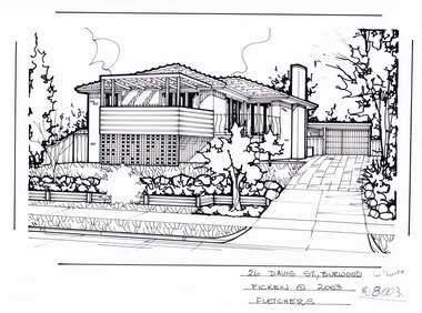 Whitehorse Historical Society Inc.
Artwork, other - Ink Line Drawing, 26 Davis St., Burwood, 2003
A property illustration by Margret Picken Commissioned by the real estate agency Fletchers for the purpose of advertising 26 Davis St., Burwood for sale in 2003. Made by using Rotring ‘Rapidigraph’ drafting pens with Rotring ink on Rapidigraph polyester drafting film, double matte. This property is listed as having sold for in 2003 $373,000 Trained as a cartographic draftsman within the mining industry, Margaret Picken is an artist who worked producing property illustrations for real estate agencies in eastern suburbs of Victoria from 1983-2005. Retiring from the industry as technological changes favoured coloured photography over illustrations, and commissioning companies over sole contractors.This artwork is of Historical Significance as a record of local domestic architecture.A black ink line drawing on drafters film by Margaret Picken, of 26 Davis St., Burwood. Depicted is a two-story brick house situated back from a front lawn with a large tree, and a driveway on the right, leading to a garage26 Davis St., Burwood Picken © 2003 Fletcherswhitehorse historical society, schwerkolt cottage, housing, architecture, margaret picken, burwood, house, garden