Showing 654 items
matching kew- cotham road
-
 Kew Historical Society Inc
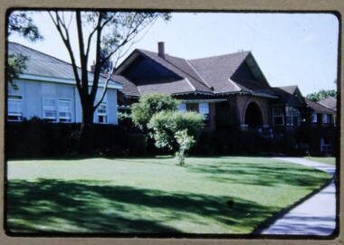
Photograph - 'Reno', 10 St John's Parade, John T Collins, 1977
‘Reno’, stood on the east side of St John’s Parade. Its earliest recorded owner was the architect Samuel Cocking who lived there from c.1865 until his death in 1888. The original landholding was bordered by Cotham Road, Glenferrie Road, Wellington Street, and Charles Street. The southern portion of this land included a fine orchard, with many imported trees. The old summer house, at first in the orchard, was later removed to the house garden. The MMBW Detail Plan No.1576 (1904) shows the remaining portion of the original land holding, including a semi-circular pathway at the front, and garden features such as an aviary, a fountain and grotto, and a fernery. The garden including rare plants supplied by Baron Von Mueller, surrounds the cottage in a tangled frenzy. Despite a ‘local significance’ classification by the National Trust, the house was demolished in 1977.Side of the original, relocated summer house of 'Reno' at 10 St John's Parade, Kew, (demolished 1977). Architectural elements revealed in this photo by John T Collins include: four-sided construction; trellis and weatherboard walls; corrugated iron roofing. Re-use as woodshed. General dilapidated condition. "Kew 'Reno' 10 St Johns Pde / John Collins, 11 Anderson Road, Hawthorn East, 3123, Film 35B Exposure 24"reno - st john's parade -- kew (vic.), john t collins -
 Kew Historical Society Inc
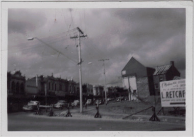
Photograph - Kew Junction during road widening, December 1958
Kew Junction is the intersection of five major roads - Denmark Street, High Street, High Street South, Studley Park Road and Princess Street. The original widening of High Street in the 1930s expanded that street by removing shops on the south side of the street from Cotham Road to Denmark Street. Further widening in 1958 removed shops at the west end of High Street to allow for increased traffic using Princes Street and Denmark Street.Original, black and white positive of Kew Junction, including the corner with Denmark Street during road widening in the 1958.Inscribed verso: "Kew Junction Dec 1958 / When the road was being widened by the removal of a number of shops / Notice saying Retchford's Estate agency's temporary office is at the top end of Denmark Street, Kew"kew junction, denmark street -- kew (vic.), major roadworks -- kew (vic.) -
 Kew Historical Society Inc
Photograph - Kew War Memorial, 1927
... at the apex of Cotham Road and High Street, Kew. It was built... of Cotham Road and High Street, Kew. It was built to commemorate ...The Kew War Memorial was planned and constructed at the apex of Cotham Road and High Street, Kew. It was built to commemorate those soldiers from Kew who served in the First World War. The Memorial was designed by the architect Harry Tompkins. It was unveiled by the Governor of Victoria in 1925.An early photograph of this iconic Memorial that locates it in its context. Small black and white photographic positive showing the Kew War Memorial in 1927, two years after its opening. The shops, known then as 'The Block' can be seen behind the Memorial.Annotated verso "Kew Memorial"kew war memorial, war memorials -- kew -- victoria -- australia, architects - harold tompkins, cotham road, high street -- kew (vic.), wwi -
 Kew Historical Society Inc
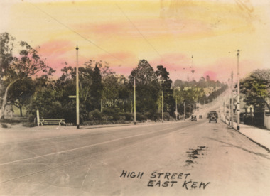
Postcard - High Street, East Kew, c.1927
High Street, Kew is the main Road in Kew. It was once also known as Bulleen Road, or Main Street. This section of the road is in Kew, although the narrow section on the right hand side of the photo is now Kew East. High Street progresses through a number of significant road junctions: beginning at Barkers Road; progressing through the intersection of Studley Park Road, Denmark Street and Princess Street at Kew Junction; branching left at the junction with Cotham Road; before reaching the junction with Valerie Street and Harp Road. It reaches its end at the junction of Burke Road, Kilby Road, Bulleen Road and High Street itself. An early photograph of this iconic Memorial that locates it in its context. Small, colorised real photo postcard of High Street, East Kew. Electric light poles line the road. Victoria Park is on the left and further on the horizon is the Boroondara General Cemetery.high street -- kew (vic.), victoria park, tram lines -- kew (vic.) -
 Kew RSL
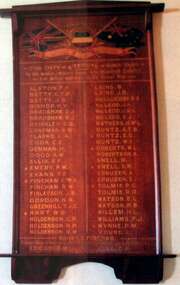
Honour Board, Kew Bowling Club's World War 1 Honour Board
Originally on display at the Kew Bowling Club in Wellington Street Kew; relocated on closure to Auburn Heights Sports Club, Barkers Road Kew; given to KewRSL 2015A Kew Honour Board listing members of the Kew Bowling Club who served in World War 1large wooden frame, gold leaf writing & painted motifKew Bowling Club 1914-1918 Roll of Honour For Duty - A Tribute - Nobly Done To the Members & Member's Sons who Voluntarily Enlisted - For Active Service in the Great War -
 Melbourne Legacy
Slide, Stanhope, 1950s
... Road Kew (corner of Cotham Rd). It was purchased by Red Cross... education. It was at 1245 Burke Road Kew (corner of Cotham Rd ...Slide photographs of the exterior of Stanhope on a sunny day with children sitting on the lawn. Believed to be from from the 1950s. Stanhope was a residence run by Melbourne Legacy to take care of children whose fathers were deceased servicemen, and who may have been left orphans, or whose mother may have been unable to care for them herself, or they needed to stay in Melbourne for further education. It was at 1245 Burke Road Kew (corner of Cotham Rd). It was purchased by Red Cross in 1945 who refurbished it and leased it back to Legacy for as long as it was required as a residence for junior legatees. It was handed back to Red Cross in 1981. Stanhope generally looked after girls over 14 either studying or working. The children were cared for until they were old enough to become independent. The slides have been photographed to make digital images and moved to archive quality sleeves. In many cases the original images were not well focussed and the digital image is the best available.A record of the outside of Stanhope.Colour slide x 2 of the exterior of Stanhope with children sitting on the lawn, in a cardboard mount.Imprinted with slide numbers, 14 and 16. Handwritten on front 'Stanhope' in black pen.stanhope, residences -
 Melbourne Legacy
Slide, Stanhope, 1950s
... Burke Road Kew (corner of Cotham Rd). It was purchased by Red... Road Kew (corner of Cotham Rd). It was purchased by Red Cross ...Slide photograph of the exterior of Stanhope on a cloudy day. Believed to be from from the 1950s, very similar to 02511 and could be from the same film. Stanhope was a residence run by Melbourne Legacy to take care of children whose fathers were deceased servicemen, and who may have been left orphans, or whose mother may have been unable to care for them herself, or they needed to stay in Melbourne for further education. It was at 1245 Burke Road Kew (corner of Cotham Rd). It was purchased by Red Cross in 1945 who refurbished it and leased it back to Legacy for as long as it was required as a residence for junior legatees. It was handed back to Red Cross in 1981. The slides have been photographed to make digital images and moved to archive quality sleeves. In many cases the original images were not well focussed and the digital image is the best available.A record of the outside of Stanhope.Colour slide of the exterior of Stanhope sitting on the lawn, in a cardboard mount.Imprinted with slide number 12. Handwritten on front 'Stanhope' in black pen.stanhope, residences -
 Melbourne Legacy
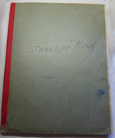
Book - Scrapbook, Stanhope News
... education. It was at 1245 Burke Road Kew (corner of Cotham Rd... education. It was at 1245 Burke Road Kew (corner of Cotham Rd ...A book compiled about the Legacy children's residence called Stanhope. It includes photos of junior legatees and names and addresses used to contact past residents about the reunions held each year. Also newspaper clippings about significant events for the residents. Examples include when the junior legatees graduated from their courses, such as pharmacy or nursing. Also when girls had married and had children. Stanhope was supervised by Matron Dorothy (Dorrie) Vines from the time it opened in 1946 until she retired in December 1966. It is likely she compiled this notebook as she is referred to as 'self' in one photo.. Individual pages of photos or newspaper clippings have been added separately. Items 01817 to 01834. Stanhope was a residence run by Melbourne Legacy to take care of children whose fathers were deceased servicemen, and who may have been left orphans, or whose mother may have been unable to care for them herself, or they needed to stay in Melbourne for further education. It was at 1245 Burke Road Kew (corner of Cotham Rd). It was purchased by Red Cross in 1945 who refurbished it and leased it back to Legacy for as long as it was required as a residence for junior legatees. It was handed back to Red Cross in 1981.A record of life at Stanhope that was compiled during the years it was operating. A great example of the impact the residence and care had on the lives of the junior legatees.Notebook used to store photos, notes and newspaper clippings about Stanhope and the reunions held. Blue cover held on with red tape.residences, dorothy vines, stanhope -
 Kew Historical Society Inc
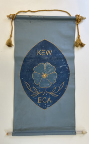
Banner - Kew Elder Citizens Association banner
The Kew Elderly Citizen's Association was formally established in 1952. During its initial years it met at South Esk in Cotham Road. Later the Club moved to its headquarters in High Street. During the period of its existence, the club changed its name a number of times It finally became known as the Kew Senior Citizens.Handmade and painted canvas banner in shades of blue with a golden cord with tassels. The banner represents the symbol of the Kew Elder Citizens Association: a forget-me-not in the centre with laurel leaves below. "KEW / E.C.A."kew elderly citizens association, kew elder citizens, kew senior citizens, community groups -- kew (vic.), banners -
 Kew Historical Society Inc
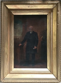
Painting - John Halfey, c.1882
John Halfey (1825-89) was born in Southport, Lancashire and migrated to Victoria in 1852. After finding gold at Sandhurst, and representing the latter in the Victorian Parliament, he moved to Melbourne to engage in various commercial pursuits, including directorships of insurance, mining and banking companies. A resident of Kew from the late 1850s, he was known for the hospitality provided at his house Ordsall (later Southesk) in Cotham Road. On 14 December 1860, Halfey chaired a public meeting calling for separation from the Boroondara Roads Board, which led, four days later, to the proclamation of Kew as a separate municipality. He was elected to the Council in 1861, replacing Cr. Oswin, and subsequently served as the second Chairman of the Municipality in 1862-1863. John Halfey became a trustee of Holy Trinity Church in Bulleen Road (now High Street) in 1862. He was to resign from Council after four years in 1865. Twenty-four years later in January 1889, he died aged 63 from a seizure, at his rooms at the Herald Office. He was interred in the Boroondara General Cemetery where his monument is the tallest in the Cemetery. Donated by Eileen Grigg, 2017Small, full-length portrait of John Halfey in an original gilded frame. The artist depicts him formally dressed in a frock coat beside an open window. He is shown holding a document or perhaps a pair of gloves. The painting is badly damaged with a hole in the area of his face that has been patched and repainted.john halfey, ordsall, chairman of kew, boroondara roads board, municipality of kew -
 Kew Historical Society Inc
Painting, W Nicholls Anderson, Adeney Avenue, Kew, 1906
William Nichols Anderson (1873-1927) was an Australian painter, one of whose works from the 1906 series River + Rail is in the Kew Historical Society’s art collection (donated 1984). A separate archive file contains correspondence, biographical information (written by his niece), and locations in Kew where he lived. Much of the correspondence between the Society and the City of Kew relates to the painting and its location in the Mayor’s Room at the Kew Civic Offices, Charles Street, where it was on loan from the Society. Lucy M (Jean) Hornby, the artist’s niece and the donor of the painting was a resident of 5 and 20 Queens Street, Kew (Vic). Australian ImpressionismGift of Lucy Hornby, 1984Framed oil on canvas by W. Nicholls Anderson of Park Street, Kew (now Adeney Avenue) looking uphill in a southerly direction towards Cotham Road. The painting is dated to 1906. The two storey house at left was known as 'Eborensis'. The house is still extant on the corner of Adeney Avenue and Parkhill Road. On sticker on back of frame - Adeney Ave./1913/ £3.3.0/ 13th Annual/ Exhib. V.A.S [Victorian Artists Society]/1911 Aust Art Exhib/the Guidlhall/Swanston st Melb./ Adeney's Paddock/ Kew. £3.0.0.artists - kew - victoria - australia, victorian artists society, william nicholls anderson (1873-1927), adeney avenue kew, australian art exhibition 1911, victorian artists' society, w. nicholls anderson -
 Melbourne Tram Museum
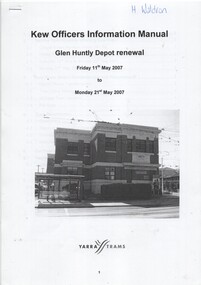
Manual, Yarra Trams, "Glen Huntly Depot Renewal", "Kew Depot - Pit Deepening Roads 1 to 4", "Camberwell Depot Yard Tracks Renewal", 2007 to 2011
Set of three Reports or Operations Plan or Manual for work at Kew and Glen Huntly Depots. .1 - 12 A4 pages - stapled - "Kew Officers Information Manual - Glen Huntly Depot renewal" - Friday 11 May 2007 to Monday 21st May 2007". Has a photo of the depot on the front sheet. Covers service changes, arrangements for changes to services running from Kew Depot, car parking, tram requirements. Has a table of contents. .2 - 7 A4 pages - stapled - "Operations Plan - "Kew Depot - Pit Deepening Roads 1 to 4" = Monday 23 June 2008 to Friday 18 July 2008" - has a table of contents, covers maintenance, tram requirements, out stabling, security, sanding and hours of operation. .3 - 19 A4 pages - stapled - "Camberwell Depot Yard Tracks Renewal" - Saturday 3 December 2011 to Monday 12 December 2011 - has a table of contents, service changes, car parking, stabling, maintenance, operations, sanding, cleaning, rosters and test trams and notice to employees. .4 - 3 A4 foolscap sheets - Co-ordinating plan for Kew Depot / Barkers Road entrance and High Street and Cotham Road - dated 25/11/2005 - list works, location, overhead, cabling, track and other works and isolation requirements. On the rear has a list of the trams for the depot, Collins St, Simpson St and Camberwell. .5 - Notes on the Kew Depot relay by Hugh Waldron received in an email dated 9/3/2018 - from Kew Depot History..1 - Has "H. Waldron" in top left hand corner in blue ink. .2 - ditto "Hugh" in red ink.trams, tramways, yarra trams, kew depot, glenhuntly tram depot, trackwork, depot fan, tram services -
 Melbourne Tram Museum
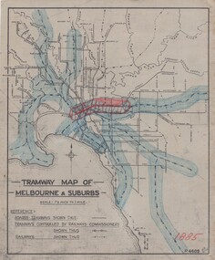
Drawing, H. S McComb, "Tramway Map of Melbourne & Suburbs", mid 1930's
Set of 19 drawings showing the development of the Melbourne tramway system between 1885 and 1921. Based on MMTB drawing "Tramway Map of Melbourne & Suburbs" P4609, 18 sheets showing year by year development of the cable and electric tram system, printed on off white paper. Mr. McComb had intended it would appear to do further work - with some 20 sheets printed on brown card paper but not used (.19 - same drawing) Each sheet has the year in red at the bottom right hand corner of the sheet. .1 - 1885 - with the Richmond line and main rail lines coloured in showing a catchment area. .2 - 1886 - shows the new cable line in Collins St and has a note that no suburban line constructed in 1886 .3 - 1887 - Bourke and northern lines and Brighton Beach to Sandringham and Hawthorn to Kew .4 - 1888 - Swanston St, Domain Road, Chapel and inner circle and towards Hurstbridge.\ .5 - 1889 - Rathdown St and Toorak Road .6 - 1890 - South and Port Melbourne, North Melbourne and Northcote. Rail lines - Ashburton and parts of the outer circle to Oakleigh. .7 - 1891 - St Kilda Esplanade and northern section of the outer circle. .8 - 1906 - NMETL .9 - 1910 - PMTT - High St and Wattletree Road .10 - 1911 - PMTT Dandenong Road .11 - 1913 - Glenferrie Road, Cotham Road, Balaclava and Glenhuntly Road .12 - 1914 - small extension in High St .13 - 1915 - Malvern Road and High St Kew .14 - 1916 - HTT and MBCTT lines and Whitehorse Road .15 - 1917 - Burke Road .16 - 1918 - Burke Road north of Camberwell station .17 - 1920 - FNPTT - St Georges Road and Plenty Road .18 - 1921 - Footscray lines .19 - base drawing only. Does not show the VR tramlines. See Reg Item 2154 for associated notes.See individual sheets.trams, tramways, times, cable trams, railways, tramways, melbourne, maps -
 Melbourne Tram Museum
Newspaper, The Age, "I've seen a tram go up in the air", "'Cheap as chips' Kew tram's horrid history", 7/10/2019 12:00:00 AM
"I've seen a tram go up in the air" by Rachel Wells & Tate Papworth Tram derailment in Cotham Rd, Kew, caused when a car collided with the 109 tram causing it to crash through a fence. About 20 people were on the tram, with two being taken to hospital. Two occupants from the car were also taken to hospital. Tram was taken back to the depot for investigation. "'Cheap as chips' Kew tram's horrid history" by Zach Hope & Tate Papworth Tram 3011 has been involved in at least 3 derailments according to Yarra Trams. Union spokesperson Phil Altieri said the poor design of the Citadis C-class model was to blame for the latest derailment. He said the trams were unstable and should be withdrawn from service.trams, tramways, c class, derailments, accidents, citadis, cotham rd, derailments, tram 3011 -
 Melbourne Tram Museum
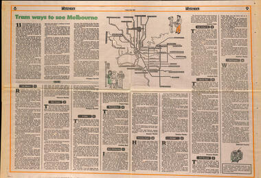
Newspaper, The Age, "Tram ways to see Melbourne", 8/5/1981
Newspaper clipping, from The Age, Weekender, Friday 8/5/1981 titled "Tram ways to see Melbourne", with a number of writers giving a short piece on a particular line. Has a Map of the Melbourne system with destination and route numbers. Has an introduction written by Phillipa Hawker which looks at the history, its place in Melbourne, and possibilities for the future. Written just before the MTA came into existence. Items: East Malvern, Route 3, Rebecca Batties West Preston Route 10, Phillipa Hawker St Kilda, Route 12, Frank Prain North Balwyn, route 48, Andrew Bolt West Maribyrnong route 57, Rosslyn Beeby Essendon Airport, Route 59, Rosslyn Beeby Carnegie, Route 67, Andrew Bolt Kew Cotham Rd, route 69, Andrew Bolt Wattle Park, route 70, Rosslyn Beeby East Burwood, route 75, Rosslyn Beeby East Preston, route 88, Deborah Forster Has some sketches of trams and people.trams, tramways, melbourne, people and places, tourism, east malvern, west preston, st kilda, north balwyn, west maribyrnong, essendon airport, carnegie, kew- cotham rd, wattle park, east burwood, east preston, route 3, route 10, route 12, route 48, route 57, route 59, route 67, route 69, route 70, route 75, route 88, maps -
 Melbourne Tram Museum
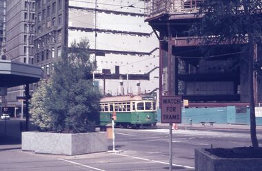
Negative, Wal Jack, 4/01/1943 12:00:00 AM
Black and white negative, by Wal Jack, of maximum traction tram N 118 (Kew Cotham Rd Route 69) and possibly CW5 682 passing. The driver of 118 has his handles and point bar in hand while attending to the pole. N 118 is on turning loop track at the intersection of Carlisle St and The Esplanade. Photo dated 4-1-43 in the Wal Jack album along with details of the location and the tramcar.trams, tramways, st kilda, the esplanade, route 69, carlisle st, n class, tram 118, cw5 class, tram 682, world war ii -
 Melbourne Tram Museum
Negative, Wal Jack, 19/01/1941 12:00:00 AM
... Trams tramways Glenferrie Road Riversdale Road W2 class Kew ...Black and white negative by Wal Jack of W2 448 at the intersection of Glenferrie Road and Riversdale Road tram stop, with passengers boarding or having left the tram. Note the tram stop sign on the shop verandah. In the background is the building advertising John Purvis, Property sales and Federal Mutual life insurance. ON the opposite side is a Milk bar, advertising Swallow's Ice creamtrams, tramways, glenferrie road, riversdale road, w2 class, kew- cotham rd, route 69, passengers, tram 448 -
 Melbourne Tram Museum
Album - Robert Thomson Slide Collection, AETA Convention 1978 Melbourne, 1978
Photo - see pdf file for further information. Number Brief Description RT175 St Kilda Carlisle St - tram 966 - "Kew Cotham Rd" - route 69 RT176 Pantograph W Class RT177 Z Class 91 Preston 28-3-78 - tram 91 - " Northcote Dundas St via High St" RT178 Z Class cars Preston 28-3-78 RT179 Wheel Transport Car 16W "Q" Class Preston 28-3-78 RT180 Z Class 51 Royal Park Res Track 27-3-78 - tram 51 -"Special" RT181 W6 - 990 - Glen Iris Terminus 26-3-78 "City" - route 6 RT182 w7-1007 Elizabeth Street Terminus 24-3-73 "Essendon Airport" - route 59 RT183 Z Class 51 Napier St Siding Essendon 27-3-78 - "City" RT184 Volvo Bus Swanston - Flinders 24-3-78 - "Bulleen via North Kew" - route 202 RT185 W6 - 878 Burwood Old Terminus 26-3-78 - "Spencer St" - route 74 RT186 W6 - 878 Burwood Old Terminus 26-3-78 - "Spencer St" - route 75 RT187 East Burwood Andrews Street 26-3-78 RT188 East Burwood Elgar Road 26-3-78 RT189 East Burwood Reservation Parer Street 26-3-78 RT190 East Burwood Terminus 26-3-78 RT191 East Burwood Terminus 26-3-78 RT192 "6" RT193 "5" RT194 "4" RT195 "3" RT196 "2" RT197 "1" Z Cars under constructionDemonstrates the work of Robert Thomson in photography, collection and/or production of slidesAssembled album in a black presentation folder of 23 colour slides, collected or produced by Robert Thomson. All photographs have been scanned and placed on the Museum's G drive. A list of all photographs with details has been compiled. melbourne, tramways, trams -
 Melbourne Tram Museum
Album - Robert Thomson Slide Collection, "Melbourne AETA 1964", 1964
Photo - see pdf file for further information. Number Brief Description RT198 SW6 888 Dandenong Rd 1-4-64 - "Malvern Rd Burke Rd" - route 5 RT199 W2 552 Dandenong Rd 1-4-64 - "City" - route 5 RT200 W3 655 Dandenong Rd 1-4-64 - "City" - route 64 RT201 SW6 951 St Kilda Beach 1-4-64 - "Kew Cotham Rd" - route 69 RT202 10 W3 667 East Coburg 1-4-64 - "South Melb Beach" - route 1 RT203 W5 826 top of Latrobe St (?) 1-4-64 - "City via La Trobe St" - RT204 L 105 Carnegie 1-4-64 -"city" - route 4 RT205 L 101 Carnegie 1-4-64 - "University" - route 4 RT206 tram 612 - "Burwood" - Batman Ave (?) RT207 Y1 611 Batman Ave 4-4-64 - "Wattle Park Elgar Rd" RT208 Hawthorn Depot 25-3-64 - trams 582 & 841 RT209 L 105 City Swanston St 25-3-64 route 4B RT210 SW6 853 Chapel St Richmond 25-3-64 -"Prahran" - route 77 RT211 L 102 City Swanston St 25-3-64 - "Carnegie" - route 4 RT212 27-4-62 - tram 495 - "Camberwell" - route 7 & tram 334 RT213 tram 11 - "Special" Flinders St RT214 March 1964 - tram 779 - "West Coburg via William St" - route 55 RT215 March 1964 W7 Collins St - tram 1024 - "Northcote via St Georges Rd" - route 9A RT216 March 1964 Victoria Parade - tram 892 - "City" - route 42 RT217 March 1964 Spring St - tram 1034 - "East Preston" - route 88 RT218 March 1964 Essendon Terminus - tram 741 - "City" - route 59 RT219 1964 AETA Convention - tram 672 - "City" RT220 1964 AETA Convention - tram 672 - "West Coburg Bell St" RT221 1964 AETA Convention - tram 676 - "Leura Grove" RT222 1964 AETA Convention - tram 672 - "Special" tram bridge RT223 1964 AETA Convention - tram 672 - "Special" RT224 1964 AETA Convention - tram 676 - "Burwood" RT225 1964 AETA Convention - tram 672 - "City" - route 59 RT226 1964 AETA Convention - tram 672 - "Special" RT227 1964 AETA Convention - tram 469 - "Special" & tram 895 - "City" - route 2A RT228 1964 AETA Convention - tram south melb depot works yard Demonstrates the work of Robert Thomson in photography, collection and/or production of slidesAssembled album in a black presentation folder of 31 colour slides, collected or produced by Robert Thomson. All photographs have been scanned and placed on the Museum's G drive. A list of all photographs with details has been compiled. melbourne, tramways, trams, mmtb, hawthorn depot, sw6 class, w2 class, w3 class, w4 class, w5 class, w7 class, y class, y1 class, x2 class, sw5 class, l class, south melbourne per-way yard, tram 11, tram 3, tram 9, tram 485, tram 676, tram 672, tram 1024, tram 1034, tram 841, tram 469, tram 611, tram 612, tram 101, tram 102, tram 105, tram 826, tram 779, tram 741, tram 655, tram 467, tram 552, tram 582, tram 495, tram 334, tram 888, tram 951, tram 853, tram 892, tram 895, route 59, route 2a, route 88, route 42, route 9a, route 55, route 7, route 4, route 77, route 4b, route 1, route 69, route 64, route 5 -
 Melbourne Tram Museum
Album - Robert Thomson Slide Collection, "Melbourne 14/9/91 to 21/9/91 16.11.1997 to 23.11.1997", 14/9/91 to 21/9/91, 16.11.1997 to 23.11.1997
Photo - see pdf file for further information. Number Brief Description RT229 1997, Carlisle St, tram 129 - "Kew - Cotham Rd" - route 69 & tram 905 - "St Kilda Beach" - route 16 RT230 1997, Dandenong Rd, tram 86 - "Melbourne" - route 69 RT231 1997, Victoria Pde, tram 856 - "City Circle" - route 00 RT232 1997, Spring St, tram 909 - "City Circle" - route 00 RT233 1997, Swanston St, tram 982 - "University" - route 72 RT234 1997, Swanston St, tram 949 - "Glen Iris" - route 6 & tram 852 - "St Kilda Beach" - route 16 RT235 1997, Swanston St, tram 845 - "University" - route 16 RT236 1997, Swanston St, tram 951 - "?" - route 8 RT237 1997, Flinders St, tram 925 - "City Circle" - route 00 7 tram 2034 - "City La Trobe St" RT238 1997, Tram Defect, tram 98 RT239 1997, Flinders St Station, tram 785 - "?" - route 8 RT240 1997, Flinders St Station, tram 211 - "Moreland" - route ? RT241 Bourke St, tram 2059 - "City Spencer St"- route 87 RT242 St Georges Rd Preston, tram 1003 - "Preston" via St Georges Rd"- route 9 RT243 West Preston Terminus - tram 943 - "St Kilda Beach" - route 10 RT244 Princes Bridge , tram 950 - "City" - route 72 RT245 1997 Port Melb Ter, tram 265 - "Mont Albert" - route 109 RT246 1997 Port Melb Terminus RT247 1997 Port Melb Terminus, tram 285 - "Mont Albert" - route 109 RT248 North Balwyn Terminus, tram 244 - "City Lonsdale St" - route 48 RT249 1997 Bourke St mall, tram 2127 - "Bundoora RMIT" - route 86 RT250 1997 Bourke St mall, tram 2028 - "St Kilda Beach" - route 96 RT251 1997 Batman Ave, tram 239 - "Princes Bridge" - route 70 RT252 1997 Batman Ave Ter, tram 233 - "Wattle Park" - route 70 RT253 Princes Bridge , tram 960 - "City" - route 64 RT254 Swanston St at Flinders St, tram 776 - "Glen Iris" - route 6 & tram 809 - "Toorak" - route 8 RT255 Swanston St at Bourke St, tram 978 - "City" - route 64 RT256 Bourke St at Swanston St, tram 112 - "City" - route 86 RT257 South Melbourne Beach terminus, tram 818, - "East Coburg" - route 1 RT258 Carlisle St, tram 925 - "Kew Cotham Rd" - route 69 RT259 Acland St Terminus, tram 2018 - "East Brunswick" - route 98 RT260 St Kilda Rd Princes Bridge, "St Kilda Beach" - route 15 RT261 Batman Avenue Terminus, tram 24 "Special" & tram 22 - "Wattle park Elgar Rd" - route 70 RT262 Acland St Terminus, tram 646 - "City" - route 16 RT263 Bundoora Terminus - tram 2023 - "Bundoora" - route 86 Demonstrates the work of Robert Thomson in photography, collection and/or production of slidesAssembled album in a black presentation folder of 35 colour slides, collected or produced by Robert Thomson. All photographs have been scanned and placed on the Museum's G drive. A list of all photographs with details has been compiled. melbourne, tramways, trams -
 Melbourne Tram Museum
Album - Robert Thomson Slide Collection, "Melbourne 1970 - 1979", 1970 - 1979
Photo - see pdf file for further information. Number Brief Description RT264 Elizabeth St, at Bourke St, with the construction of the State Savings Bank building (State Bank Galleria) underway. Bourke St Mall also under construction, Note tram warning Sign, tram 1065 - "West Maribyrnong" - route 57 RT265 St Kilda Road, tram 778 - "City" -route 59 RT266 St Kilda Road, tram 569 - "East Malvern Darling Road" -route 3 & tram 819 - "Glen Iris" - route 6 RT267 Swanston St, tram 538 - "City" - route 2A RT268 St Kilda Junction, tram 924 - "City" - route 5 RT269 St Kilda jct, tram 280 - "St Kilda Beach" - route 15 RT270 St Kilda Road, tram 507 - "City" - route 72 RT271 Nicholson St Gertrude St - tram7 - "East Preston Tyler St" - route 88 RT272 West Coburg, tram 778 - "Domain Rd" - route 55 RT273 Wests Road, tram 750 - "Moonee Ponds" - route 22 RT274 St Kilda Rd, tram 8 - "Special" RT275 Nicholson St Victoria Pde, tram 10W - "Special" RT276 L Class Queens way, "City" - route 54 RT277 Bourke St at Spring St, tram 998 - "East Coburg" - route 88 RT278 Nicholson St MMTB Bus, bus 562 - "Garden City via Port Melb" - route 2 RT279 Church St Burwood Rd Jct, tram 9 - "Special" RT280 Riversdale Rd at Camberwell Depot - "Burwood" - route 74 RT281 Balaclava Junction - tram 819 - "Kew Cotham Rd" - route 69 RT282 East Brunswick Terminus, tram 4 - "City Spencer St" - route 96 RT283 Peel St - tram 927 - "Special" RT284 East Brighton Terminus - tram 563 & tram 926 - "City" - route 64 RT285 Dandenong Rd Hawthorn Rd, tram 346 - route 64 RT286 Bourke St at Spring St, tram 34 - "North Fitzroy Park St" - route 97 RT287 Route 69 Terminus St Kilda - tram 369 - "Kew Cotham rd" - route 69 RT288 Route 78 Terminus St Kilda, tram 498 - "North Richmond" - route 78 RT289 Track relay, Fitzroy St, St Kilda RT290 Fitzroy St, St Kilda Demonstrates the work of Robert Thomson in photography, collection and/or production of slidesAssembled album in a black presentation folder of 27 colour slides, collected or produced by Robert Thomson. All photographs have been scanned and placed on the Museum's G drive. A list of all photographs with details has been compiled. melbourne, tramways, trams, track construction, elizabeth st -
 Melbourne Tram Museum
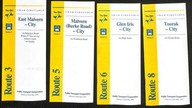
Ephemera - Timetable - The Met - set of 16, The Met, 1993
SSet of 16 The Met timetables, diagrammatic map, major stops and contact details. All dated May 1993 unless noted otherwise. 1 - Route 3 - East Malvern - City with a note that route 377 bus service replaces trams on Sunday. 2 - Route 5 - Malvern (Burke Rd) - City 3 - Route 6 - Glen Iris - City 4 - Route 8 - Toorak - City 5 - Route 10 - Sth Melbourne Beach and St Kilda Beach - West Preston 6 - Route 19 - North Coburg - City with a note that route 319 bus service to Gowrie and Upfield was included - ran Saturday afternoons and Sundays only. 7 - Route 42 - Mont Albert - City 8 - Route 48 - North Balwyn - City 9 - Route 55 - West Coburg - Domain Road interchange - with a note that route 68 operates via Elizabeth St on Sunday. 10 - Route 57- West Maribyrnong - City - with a note that route 357 bus services replaces trams on Sunday 11 - Route 59 - Airport West - City 12 - Route 64 - East Brighton - City 13 - Route 69 - Kew (Cotham Rd) - St Kilda Beach via Glenferrie Road 14 - Route 70 - Wattle Park - Princes Bridge 15 - Route 72 - Camberwell - City 16 - Route 82 - Moonee Ponds - Footscray and that route 223 bus replaces trams on Saturday afternoons and all day Sunday,Yields information about some of The Met tram services May 1993Set of 16 The Met timetables, DL size, printed in two colours.timetables, the met, route 8, route 3, route 5, route 6, route 10, route 19, route 42, route 48, route 55, route 57, route 59, route 64, route 69, route 70, route 72, route 82 -
 Melbourne Tram Museum
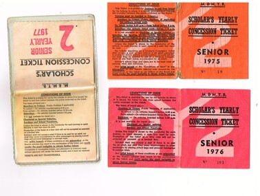
Ephemera - Ticket/s, Melbourne & Metropolitan Tramways Board (MMTB), "Scholar's Yearly Concession Ticket", 1975 to 1977
Set of two clothed backed paper tickets, printed as a MMTB "Scholar's Yearly Concession Ticket", for Seniors and one paper ticket contained within a plastic envelope. Gives condition of use on the outside cover. Each issue to Roderick Atkins. Each lists the various terms for which they were available and available from Cotham and Glenferrie Road, to Callantinia Road, Scotch College. Two sections. .1 - Orange cloth, Senior 1975, cost not shown No. 18 .2 - red cloth, Senior 1976, cost $39.00 No. 203 issued at Doncaster Depot .3 - light yellow paper within a plastic envelope, Senior 1976, cost $39, No. 42583, issued at Kew Depot. See Reg Item 5571 for other examples of item 3trams, tramways, mmtb, tickets, schools, schools tickets, scholar's tickets -
 Kew Historical Society Inc
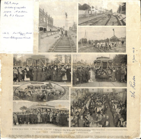
Article, The New Electric Tramway, Malvern to Kew
... photographs were taken by E J Dower. No.3 Cotham Road Kew near... photographs were taken by E J Dower. No.3 Cotham Road Kew near ...One of a group of photographs, including three within a published photo collage , taken by Edgar James Dower in the second decade of the twentieth century. Born and raised in Olinda, Dower later moved to Surrey Hills. He worked as an adult as a clerk in the city office of the Metropolitan Gas Company, and in his role as a 'collector', he was able to photograph scenes including the construction of tramlines, railways and associated buildings in Kew, Hawthorn, Camberwell and Surrey Hills. Later he established a real estate agency with his brother - the E.J. Dower Real Estate Agency, Mount Dandenong Office.The photo collage is an historically significant record of the development of transport infrastructure which was used to connect Victorians in the first two decades of the twentieth century. This development resulted from increases in population and the consequent extension of Melbourne's suburbs. The photographs, both individually and collectively, richly detail the labour of workers and the tools and machinery used to create and extend Melbourne's public transport network in the years preceding and during World War 1.Photo collage, published in The Leader newspaper in 1913, to commemorate the opening of the Malvern to Kew Tramway. The numbered photos are: 1. Kew Railway Gates at Glenferrie. 2. Burke Road Terminus. 3. Final Stages. 4. Ladies at the Official Opening. 5. The Acting Mayoress of Kew Cutting the Ribbon at the Kew Boundary. 6. Mayor and Councillors at the Kew Terminus. 7. The Cutting the First Ribbon. 8. Guests at the Hawthorn Town Hall.Inscribed in ink by Edgar J Dower top left: "The 3 top photographs were taken by E J Dower. No.3 Cotham Road Kew near Glenferrie Road"theme -- connecting victorians by transport and communications, theme -- travelling by tram