Showing 3765 items
matching black hall
-
 Kiewa Valley Historical Society
Posters - "Tawonga Remembers" x 5
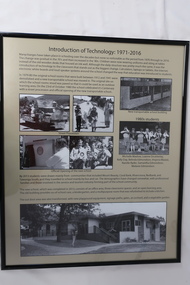
The town of Tawonga is in the Kiewa Valley surrounded by farmland. It is adjacent to Mt Beauty (built from 1946), an SECV town built for the workers on the Kiewa Hydro Electric Scheme which was being constructed from 1911-to 1961. Tawonga consisted of essential amenities including a store, school, butter factory, sporting facilities, post office, hall and hotel. Activities involved sport, social get togethers eg. dances, fundraising, CWA etc.The posters are a collection of historical photos, documentation and information regarding the history of the town of Tawonga, which is the centre of a farming community in the Kiewa Valley.Posters framed with thin black plastic strip, covered by glass. Each one has a title re "Tawonga Remembers" and includes print and photos in black and white. Beige background. 1.Butcher Shop and Slaughter Yard; 2. Tawonga Saw Mill; 3. Post Office; 4. Tawonga District Hospital (2 pages); 5. Introduction of Technology: 1971-2016tawonga, photos of early tawonga, kiewa valley, tawonga remembers, businesses -
 Kiewa Valley Historical Society
Posters - "Tawonga Remembers" x 5
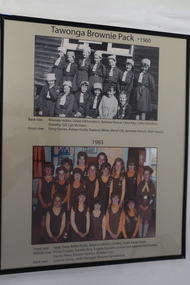
The town of Tawonga is in the Kiewa Valley surrounded by farmland. It is adjacent to Mt Beauty (built in 1946) , an SECV town built for the workers on the Kiewa Hydro Electric Scheme which was being constructed from 1911-1961. Tawonga consisted of essential amenities including a store, school, butter factory, sporting facilities, post office, hall and hotel. Activities involved sport, social get togethers eg. dances, fundraising, CWA etc.The posters are a collection of historical photos, documentation and information regarding the history of the town of Tawonga, which is the centre of a faming community in the Kiewa Valley.Posters framed with thin black plastic strip, covered, by glass. Each one has a title re "Tawonga Remembeers" and includes print and photos in black and white. Beige background. 1. The History of Guiding in Tawonga; 2. Tawonga Cubs; 3. Cubs and Scouts; 4. Tawonga Brownie Pack -1960; 5. Tawonga Guide Company -1966tawonga, photos of early tawonga, kiew valley, tawonga remembers, cubs, scouts, brownies, guides -
 Kiewa Valley Historical Society
Posters - "Tawonga Remembers" x 5
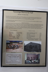
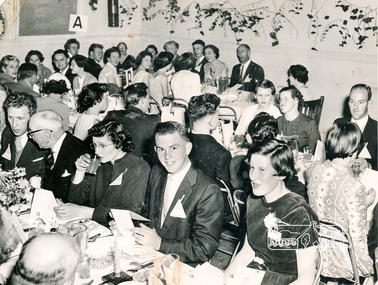
The town of Tawonga is in the Kiewa Valley surrounded by farmland. It is adjacent to Mt Beauty (built from 1946), an SECV town built for the workers on the Kiewa Hydro Electric Scheme which was being constructed from 1911-1961. Tawonga consisted of essential amenities including a store, school, butter factory, sporting facilities, post office, hall and hotel. Activities involved sport, social get togethers eg. dances, fundraising, CWA etc. The posters are a collection of historical photos, documentation and information regarding the history of the town of Tawonga, which is the centre of a farming community in the Kiewa Valley.Posters framed with thin black plastic strip, covered, by glass. Each one has a title re "Tawonga Remembers" and includes print and photos in black and white. Beige background. 1. Tawonga Memorial Hall 2. Opening of the Second Public Hall 1925 3. Public Hall for Tawonga 4. Tawonga Debutante Ball 1947 5. Tawonga Hall Ghosttawonga, photos of early tawonga, kiewa valley, tawonga remembers, tawonga hall -
 Kiewa Valley Historical Society
Posters - "Tawonga Remembers" x 4
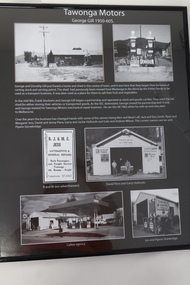
The town of Tawonga is in the Kiewa Valley surrounded by farmland. It is adjacent to Mt Beauty (built in 1946), an SECV town built for the workers on the Kiewa Hydro Electric Scheme which was being constructed from 1911 to 1961. Tawonga consisted of essential amenities including a store, school, butter factory, sporting facilities, post office, hall and hotel. Activities involved sport, social get togethers eg. dances, fundraising, CWA etc.The posters are a collection of historical photos, documentation and information regarding the history of the town of Tawonga,which is the centre of a farming community in the Kiewa Valley.Poster framed with thin black plastic strip, covered, by glass. Each one has a title re "Tawonga Remembers" and includes print and phtots in black and white. Black background. 1. Tawonga SEC Depot; 2. Tawonga Service Station circa 1940s; 3. George Johnston's Taxi Service; 4. Tawonga Motors 1950-60stawonga, photos of early tawonga, kiewa valley, tawonga remembers, transport -
 Kiewa Valley Historical Society
Posters - "Tawonga Remembers" x 4
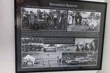
The town of Tawonga is in the Kiewa Valley surrounded by farmland. It is adjacent to Mt Beauty (built from 1946), an SECV town built for the workers on the Kiewa Hydro Electric Scheme which was being constructed from 1911 to 1961. Tawonga consisted of essential amenities including a store, school, butter factory, sporting facilities, post office, hall and hotel. Activities involved sport, social get togethers eg. dances, fundraising , CWA etc.The posters are a collection of historical photos, documentations and information regarding the history of the town of Tawonga, which is the centre of a farming community in the Kiewa Valley.Posters framed with thin black plastic strip, covered, by glass. Each one has a title re "Tawonga Remembers" and includes print and photos in black and white. Black background. 1. Recreation Reserve 2. St Aidan's Church 3. Lois Pearce 4. Boarding Housetawonga, photos of early tawonga, kiewa valley, tawonga remembers, tawonga businesses -
 Kiewa Valley Historical Society
Posters - "Tawonga Remembers" x 8
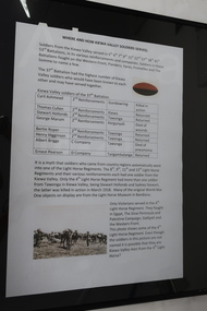
The town of Tawonga is in the Kiewa Valley surrounded by farmland. it is adjacent to Mt Beauty (built from 1946), an SECV town built for the workers on the Kiewa Hydro Electric Scheme which was being constructed from 1911 to 1961. Tawonga consisted of essential amenities including a store, school, butter factory, sporting facilities, post office, hall and hotel. Activities involved sport, social get togethers eg. dances, fundraising, CWA etc. The posters are a collection of historical photos, documentations and information regarding the history of the town of Tawonga, which is the centre of a farming community in the Kiewa Valley.Posters framed with thin black plastic strip, covered by glass. Each one has a title re "Tawonga Remembers" and includes print and photos in black and white. White background. 1. Where and How Kiewa Valley Soldiers Served; 2. Tawonga and Dederang Servicemen; 3. Kergunyah and Gundowring Servicemen and Women; 4. Kiewa and Tangambalanga Servicemen.5. Sacrifice and Honour; 6. The End of the Great War; 7. World War 1914-18; 8. Soldiers in Uniform (Black background and glass cracked) tawonga, photos of early tawonga, kiewa valley, tawonga remembers, ww1 -
 Kiewa Valley Historical Society
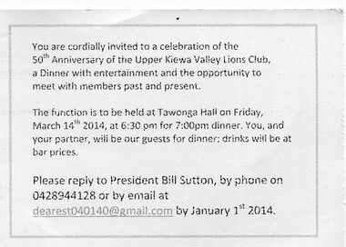
Invitation - UKV Lions Club 50th Anniversary
Lions Clubs aim to give community service and improve the lives of others. To promote the principals of good government and good citizenship. To take an active interest in the civic, cultural, social and moral welfare of the community. To unite the clubs in the bonds of friendship good fellowship and mutual understanding The UKV Lion's Club started in 1964. They celebrated their 50th Anniversary on March 14th 2014 at the Tawonga Hall.The Upper Kiewa Valley Lion's Club started in 1964. They celebrated their 50th Anniversary on 14th March 2014 at the Tawonga hall.Yellow cardboard folded in half. Lion's logo on the front surrounded by the 0 in the number 50. 'UKV Lions' is printed in green inside the circle in the number 5. The invitation is printed in black on the inside of the card on page 3. ukv lions club, community service, upper kiewa valley -
 Kiewa Valley Historical Society
Booklets and Papers - St Joseph's Catholic Church Mt Beauty, St Joseph's Catholic Church Mt Beauty Golden Jubilee 1954-2004
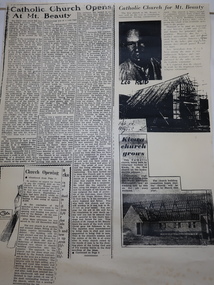
Catholics from Tawonga attended Mass at Dederang the area being part of the Myrtleford parish. With the coming of the State Electricity Commission and the increase in population Masses were said in various schools, homes and halls between Tawonga and Mt Beauty until the completion of St Joseph's ChurchSt Joseph's Catholic Church, Mt Beauty was consecrated on November 7th 1954. The SEC allocated land to each of the churches for them to provide their own places of worship. It was built by volunteers who donated money and their time to raise funds and build the church.1. Booklet with yellow cover, black print and 28 pages back to back held by 2 staples. 2. Booklet "Mass to Celebrate the 40th Anniversary of St Joseph's Church Mt Beauty 1954-1994" 4 pages back to back 3. Papers: vary - 1. A3 sheet with articles from newspapers "Catholic Church Opens At Mt Beauty"; "Catholic Church for Mt. Beauty". 2. x4 A4 sheets typed back to back -"Recalling the first 40 years" 3. St Joseph's Mt Beauty 1968-69 Lawn Cutting Roster 4. Miscellanious st joseph's mt beauty, catholic church, golden jubilee, religion -
 4th/19th Prince of Wales's Light Horse Regiment Unit History Room
Photograph, At Ballarat Drill Hall, Post 1904
... Macleod melbourne photo ballarat drill hall A black & white photo ...A black & white photo mounted on card. It shows 31 soldiers of various ranks and units. The photo was taken at the Ballarat Drill Hall and is probably of the participants in a course photo, ballarat drill hall -
 Kiewa Valley Historical Society
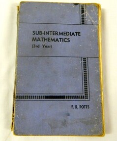
Book - Maths, Frank Roland Potts, Sub Intermediate Mathematics Third Year, 1957
This book was written to cover the whole of the sub intermediate syllabus for Victoria. Form 3 or Year 9 in todays levels This was an introduction to the higher levels of maths, e.g. Leaving certificate. This book is a very good indicator of what was taught in Victorian SchoolsThis has social significance because it shows what students of the Mt Beauty secondary schools would have been learning during the 1950's. This book has been donated by Wilma Davies, a local idenity, and has her usuage in the book. Therfore this makes this item very good interpretive capacity. It is also now out of print and there is only a couple of copies for public viewing that the Victorian State Library, so it a rare collectible book. Faded blue cover with back writing. Black pattern block and linesbook, school, maths, eductional, text-book, wilma davies -
 Kiewa Valley Historical Society
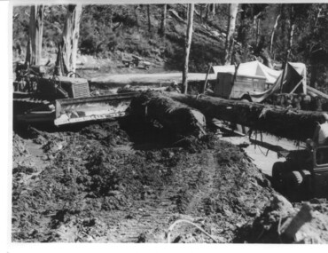
Photograph, logging at McKay Creek, Logging at McKay Creek, c1950's
This photograph was probably taken at the site of McKay Creek Power Station. Excavation of this site did not commence until 1951 but road access(a narrow track) was provided in 1948 and widened in 1954. The logs would have been milled for timber at the State Electricity Commission's mill at Howman's Gap and thus provided a much needed source of timber for construction of camps and houses as there was a general of shortage of this commodity. Because of trouble with landslides in this area, a decision was made to place the machine hall of the power station underground instead of on the surface. Restricted financial resources and the repositioning of the power station retarded construction activities and it was not completed until early 1961.. An excellent pictorial record of the general working conditions, type of machinery and vehicles in use in the 1950/s.Black and white photograph showing logging equipment, fallen logs.Handwritten on the back of the photograph "Logging at McKay Creek)logging, mckay creek, timber, machinery -
 Eltham District Historical Society Inc
Book, Nillumbik Shire Council, Celebrating Nillumbik Women 2008-2013, 2013
This book was conceived by the Nillumbik Women's Network as a way of writing women into local history. When seeking nominations for the 2010 editon, the press release stated: Nillumbik Shire’s official histories don’t reflect the important but often unacknowledged contribution of local women to the development of the area. To redress this, the Nillumbik Women’s Network (NWN) initiated a small project, Celebrating Nillumbik women in late 2007.( For details of the Nillumbik Women’s Network refer to attachment) The NWN sought nominations of local women who had made, or continue to make, a significant contribution to the social and cultural life of our community. The brief profiles of the nominees were published in a booklet, which was launched at an International Women’s Day celebration in March 2008, and a second publication was produced in 2009. We continue to be inspired by the quality and activism of our local women. Many of the biographies tell of women’s contribution to the building of the ‘social’ infrastructure of the Shire. These stories complement the official historical accounts which primarily document men’s role in building the physical infrastructure of the Shire. One begins to develop a clearer picture of how women went about developing the services which we take for granted today, from the small kindergartens operating out of church halls to the wide ranging network of occasional and long day childcare care to the development of home based services for older frail and disabled residents of the area. They also tell of the bravery and resilience of women in their response to the devastating impact of the Black Saturday bushfires. This volume includes profiles of 23 women, 2013 Nominees in addition to those included since the project was launched in 2008. The 2008 nominations are: Wendy Alexander, Jane Ashton, Sharon Banner, Janet Boddy, Catherine Cervasio, Belinda Clarkson, Helen Coleman, Cathy Dean, Judy Duffy, Gwen Ford, Jenny Graves, Cath Giles, Meera Govil, Ona Henderson, Jill Jameson, Vicki Kaye, Mrs Kimber, Nerida Kirov, Jane Lauber, Pam Lawson, Anne Manne, Chris Marks, Elizabeth Marshall, Dawn McDonnell, Jenny Millar, Grace Mitchell, Jenni Mitchell, Michelle Molinaro, Joy Murphy, Rosie Murphy, Barbara Murray, Tracey Naughton, Josephine Norman, Pamela Pederson, Mary Robertson, Vicki Ruhr, Geraldine Sanderson, Dawn Shaw, Fiona Sievers, Myra Skipper, Selina Sutherland, Barbara Talbot, Marjorie Taylor, Julie Tipene-O’Toole, Susie Walker, Donna Zander. 2009: Jan Aitken, Rosemary Aitken – OAM, Edith Apted, Betty Anderson, Thelma Barkway, Diana Bassett-Smith, Jenneke Bateman-Korteweg, Amy Bryans, Sabi Buehler, Jenni Bundy, Audrey Cahn, Linda Cornelissen, Janice Crosswhite, Elean Dansey, Christine Durham Claire Fitzpatrick, Ailsa Fitzmaurice, Lucinda Flynn, Sheryl Garbutt MP, Fran Gronow, Ev Hales, Irene “Rennie” Harrison, Ena Jarvis, Heather Kaufmann. 1948-2007: Helen Kenney, Margot Knox – Pederson, Lois Loftus-Hills, Nina Mikhailovna Christesen AM (nee Maximov), Penny Mullinar, Gwayne Naug, Nanette Oates, Lisal O’Brien, Stella Reid, Laura Rohricht, Meg Russell, Sonia Skipper, Bronwyn South, Pauline Toner MP, Lisa Walton, Diana Warrell, Rachel Watt. The 2013 nominations are: Roslyn Addison, Sue Aldred, Lucy Anderson, Sue Arnold, Mary Avola, Anna Foletta, Morag Fraser, Danielle Green MP, Colleen Hackett, Pam Hayes, Barbara Joyce, Carol Leeson, Sandra and Bruce Poloni, Many Press, Carolyn Royse, Hannah Sky, Lorna Smith, Lynlee Tozer, Kilanthi Vassiliadis, Kerry Wailes, Gale Weiss, Irma Winton and Alexis Wright.This book is a significant in the recording of the contribution of local women to the development of the Shire of Nillumbik, especially for the time frame 2008 -- 2013. Historically women's stories generally have not been told at all, let alone their contributions acknowledged. This book profiles and documents women's stories that otherwise may not have been told.women, nillumbik women's network -
 Eltham District Historical Society Inc
Book, School at the crossing place : Lower Plenty Primary School no. 1295, 1874-1974 / W.F. Henderson, 1974c
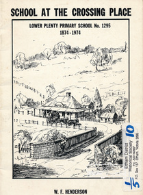
23 pages including information on inside covers. Text with black and white illustrations and photographs and map. Contents: Crossing Place Need for a school Residence for the teacher Closure A View of Lower Plenty 1918 Moving day at the Village The Golf Club Depression 1931 Vandals Electricity Grass Fires Cows at School Mothers' Club Women's liberation 1950's Lower Plenty after 1945 Swimming Pool - drowned dreams Long Grass - snakes - meadow hay - Fire Brigade The Royal Visit 1954 School Band Community Centre Our School Hall Trees and Gardens The Library Education 1874-1974 A Teacher's View The Second generation - children of ex-pupils (photo with names) The Third generation - Grandchildren of ex-pupils (photo with names) Head Teachers (list with dates) The Staff 1974 (photo with names) The sketch on the cover shows the Lower Plenty Bridge, toll house and the Plenty Bridge hotel, both no longer there. The bridge is listed in the Banyule Heritage Study and has recently been restored by Banyule Council as a pedestrian bridge - NL 137 March 2001 Paperback; [24] p. : ill. ; 25 cm.lower plenty, state school no. 1295, lower plenty primary school -
 Eltham District Historical Society Inc
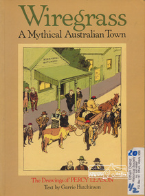
Book, Ross Publishing, Wiregrass: A Mythical Australian Town, drawings by Percy Leason, text by Garrie Hurchinson, 1986
Back Cover: At a time when black and white art was flourishing in Australia- with artists like Norman Lindsay, Will Dyson and Stan Cross at work - Percy Leason's creation of Wiregrass ranked him as an illustrator of surpassing genius. His early successes as a book illustrator and as a cartoonist for the Bulletin and Melbourne Punch, presaged a full flowering of his work with his creation of the mythical town and his endowment of it with a host of characters and comic situations. His inspiration came from his childhood town in Kaniva, Western Victoria but Wiregrass was every country town, with its general store, pub and church hall, its swimming hole, football ground and racecourse, its leading citizens, its battlers and mischievous children. Wiregrass flourished in Table Talk Magazine from 1926 to 1937 when Leason, seeking to escape his comic reputation and pursue "serious" art, went to live in America." Percy Leason lived in Eltham Softcover, 80 p. : ill., 1 port. ; 30 cm.ISBN 0850912490australian wit and humour, drawing, caricatures and cartoons, country life -
 Eltham District Historical Society Inc
Photocopy of newsclipping, Elections of long ago
Article in unknown newspaper of a reprint of an article: Elections of Long Ago, in Nhill Free Press, 1938. The article discusses William Hall Irvine's election In 1894 when he stood for the rural Legislative Assembly seat of Lowan. Irvine achieved a surprise victory .... Mr Irvine became a Premier of Victoria and Chief Justice and lived the later part of his life at Killeavey, Eltham.A4 black and white photocopysir william irvine -
 Eltham District Historical Society Inc
Photograph, George W. Bell, Looking towards trestle bridge from new Shire Hall, 1965c
Black and white photograph looking west to railway bridge over Diamond Creek from Shire Office carpark c.1965.bridges, railways, eltham, diamond creek, eltham shire office, george w bell collection -
 Eltham District Historical Society Inc
Photograph, Stuart Tomkin, Official guests being entertained Kangaroo Ground Hall after Dedication of Tower and Cottage by Governor Sir Dallas Brooks, 16 Nov 1951, 16/11/1951
... of eltham ceremonies sepp kangaroo ground hall Black and white ...Original title: Official guests being entertained Kangaroo Ground Hall after Dedication of Tower and Cottage by Gen. Sir Dallas Brooks, K.C.B., C.M.G., D.S.O., K.St.J., 16 Nov 1951Black and white photograph of guests seated at three rows of tables, celebration dinner Shire of Eltham Pioneers Photo Collection, no. 414 (duplicate of hard copy held at Eltham Library)shire of eltham, ceremonies, sepp, kangaroo ground hall -
 Eltham District Historical Society Inc
Photograph, Cake Stall at Eltham Fair, 1940s
Most likely the Eltham Springtime Fair run by the Eltham Methodist Ladies Guild and held in the Methodist HallReproduction of black and white photographeltham fair, festivals, eltham, nation, squire, boyd, edwards, carroll, battye, brown -
 Eltham District Historical Society Inc
Photograph, Anglers Hall opening Night, Para Road, Briar Hill, 1937, 1937
Black and white photograph of the opening of Anglers Hall showing the table settings and 87 men seated and standing around posing for the shotanglers hall, para road, briar hill, ceremonies -
 Eltham District Historical Society Inc
Photograph, Peter Bassett-Smith, Queen Elizabeth II Coronation celebrations and parade, Eltham, Jun 1953
Three black and white photographsalf davis, anz bank, army, arthur street, bert bredle, ceremonies, civic functions, coronation, councillors, cr e.p. harmer, cr f.v. squire, cr frederick e. griffith, cr stanley s. addison, dave lyon house, eltham hall, eltham lower park, eltham shire office, eltham village, eltham, frank davis mhr, guard of honour, main road, mr c.g. seear, mrs alf davis, mrs arthur bird, mrs e.p. harmer, mrs f.e. griffith, mrs frank davis, mrs ham, mrs s.s. addison, mrs squire, parade, queen elizabeth ii coronation, r.j. (dick) ham, shopping centre -
 Eltham District Historical Society Inc
Photograph, Peter Bassett-Smith, Queen Elizabeth II Coronation celebrations and parade, Eltham, Jun 1953
Five colour photograph copies of original black and white images of various viewsarmy, arthur street, bands, ceremonies, civic functions, coronation, councillors, cr stanley s addison, eltham, eltham hall, eltham lower park, eltham shire office, eltham village, frank davis mhr, guard of honour, lyon bros garage, main road shops, main road, milk bar, parade, queen elizabeth ii coronation, r.c. staff, staffs general store -
 Eltham District Historical Society Inc
Photograph, St Margaret's Church, Eltham, fundraising dinner, 1950s
Black and white photograph of group at church dinner to raise money for a new St Margaret's Vicarage held at Eltham Shire Hall, Arthur Street c.1950sInscribed on back with arrows indicating Rowley and self (Lilas Scale)st margarets, churches, anglican, church of england, functions, lilas scale, eltham shire hall -
 Eltham District Historical Society Inc
Photograph, Hugh Fisher, Eltham Fire Station, east side of Main Road, 1950s, 1950s
The Eltham Fire Station was opened in 31 April 1935. Years later the building was removed and erected for use of 1st Research Scout Group in Research Park by the early 1970s to make way for the Eltham Village Complex which was under construction by 1971. The Research Scout Hall was destroyed by fire in 2002.Black and white photographPhoto by Hugh Fischer, c.1950seltham, fire station, main road -
 Warrnambool and District Historical Society Inc.
Document, Ist Airmail letter 1917, 1917
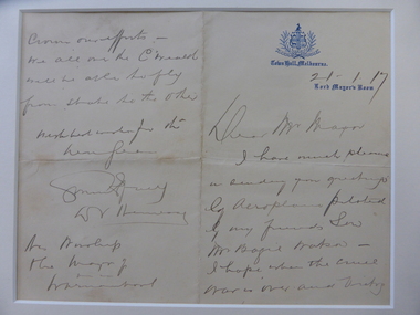
This letter, the first air mail letter sent to Warrnambool, was written by the Lord Mayor of Melbourne, Sir David Valentine Hennessy and carried by the aviator, Basil Watson on the first flight to Warrnambool January 24th 1917. The letter was delivered to the Mayor of Warrnambool, Cr Webb.There were several other letters delivered at the same time but this is the important official one. Basil Watson was a pioneer aviator who built his own aeroplane which was 18 feet long with a wing span of 26 feet and it had a 7 cylinder 50 H.P. Rotary Gnome engine. Watson flew from Point Cook to Warrnambool in one hour 55 minutes, an Australian cross-country flying record at the time. In Warrnambool Watson amazed the crowd with his dare-devil aerial acrobatics, looping the loop 14 times over the Warrnambool Racecourse. Basil Watson died when he crashed his plane into the sea near Point Cook, just two months after he landed in Warrnambool. This letter is of the utmost significance being the first air mail letter delivered to Warrnambool. It is an important memento of the first aeroplane flight into Warrnambool by the pioneer aviator Basil Watson. This is a cream-coloured sheet of paper folded in two to make four pages. It has handwriting in black ink on two pages. The writing is a little faded. The first page has the logo of the Melbourne Town Hall. The pages are partly torn at the folds. ‘Town Hall, Melbourne, 21/1/17. Lord Mayor’s Room, Dear Mr Mayor, I have much pleasure in sending you greetings by aeroplane piloted by my friend’s son, Mr Basil Watson. I hope when the cruel war is over and victory crowns our efforts, we all in the C’wealth will be able to fly from one state to the other. With best wishes for the New Year, …….. (signature indecipherable), D.V. Hennessy. His Worship the Mayor of Warrnambool.’pioneer aviation in the western district, basil watson, history of warrnambool -
 Victoria Police Museum
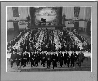
Photograph (Victoria Police), Police Officers on dinner event, February 1945
[see inscriptions] Black and white mounted photograph. Approximately 160 men (171 according to inscription on the back) sitting on large tables at a formal dinner event; all weatinh suits and posing for photograph. Photo was taken in a large rooom with a stage, Malvern Town Hall accoring to inscriptions on the back - tables occupy centre and front of photograph - but in the background: [left] Australia flag, WWII poster; [center] stage with painted landscape and piano; [right] WWII poster and Britain flag. [information of event on newspaper cutting stuck on the back - as described on Inscriptions]Handwritten: 171 PRESENT // FEB 1945 // (?) OFF SUPT KNOTT // INSPT SAMBLEBE // CONST GRAMBEU /// MALVERN TOWN HALL Newspaper cutting glued to frame: Supt. J. R. H. Knott, has rettired from the Police Force after 38 and half years' service, was farewelled by citizens and police officials at Malvern Town Hall on Tuesday night, The mayor of Malvern (Cr. J. Johnson) presided and presented SUpt. Knott with a chair and a wallet of notes. Similar presentations were made to Inspector C.H.D. Samblebe and First Constable O. Grambau, who have also retired. Supt. A.D. McKinnon of Ballarat will succeed Supt. Knott // handwritten: SUN 1/2/45victoria police museum, police officers, police academy, police force, superintendent mckinnon, superintendent knott, cr johnson, inspector samblebe, first constable grambau, poulter, william -
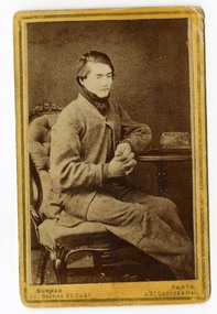 Victoria Police Museum
Carte de Visite (Dan Kelly seated), Dan Kelly
Carte-de-visite is a small black and white photograph stuck to a card. It was invented by French photographer Andre Disderi in 1854 as a method for producing multiple images on a single glass plate, a format for mounting the resulting images on cards. The card on which the photograph was mounted displayed the name of the photographer on the front and back. The back was often a showy piece of lithographic printing with the photographer's name decorated with culicues.Sepia toned photograph on cardboard showing Dan Kelly sitting "Burman Photo 200 Bourke St East & St Georges Hall (under photograph), "From Burman's Photographic Rooms 209 Bourke Street, East Near Parliament Houses. st Georges Hall Next to Theatre Royal Melbourne. Portraits Enlarged, Copied or Colored. Views taken in any part of Victoria. Copies of this can be had at any time" (on rear), "Dan Kelly" (on rear along left side in black ink), "204" (written in pencil at top left corner)dan kelly, kelly gang, ned kelly, carte-de-visite, burman -
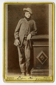 Victoria Police Museum
Carte de Visite (Dan Kelly standing), Dan Kelly (standing)
Carte-de-visite is a small black and white photograph stuck to a card. It was invented by French photographer Andre Disderi in 1854 as a method for producing multiple images on a single glass plate, a format for mounting the resulting images on cards. The card on which the photograph was mounted displayed the name of the photographer on the front and back. The back was often a showy piece of lithographic printing with the photographer's name decorated with culicues.Sepia toned photograph on card showing Dan Kelly with left arm resting on a pillar."Burman Photo 200 Bourke St - East & St Georges Hall" (under photograph). "From Burman's Photographic Rooms 209 Bourke Street. East Near parliament Houses. St Georges Hall Next to Theatre Royal Melbourne. Portraits Enlarged, Copied or Colored. Views taken in any part of Victoria. Copies of this can be had at any time: (on rear) "Dan Kelly" (handwritten in ink underneath image on front of card)dan kelly, kelly gang, ned kelly, carte-de-visite, burman -
 Australian Queer Archives
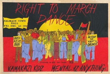
Poster, Right to march dance : Balmain Town Hall, Fri, Dec. 1st 1978, 1978
Graphic illustration of group of protest marchers holding banners against a background of the Aboriginal flag; text in black."Right to march dance : Balmain Town Hall : [featuring] Kamakazi Kidz - Mental as Anything. Defend the right to organise. Smash Bjelke's ban. Proceeds to Qld Bail Fund." -
 Warrnambool and District Historical Society Inc.
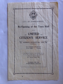
Programme - Program, Re-Opening of the Town Hall, Early August 1925
The musical portion of the service was led by the United Choirs and Orchestra I conducted by Mr E Bright. At 9 August 1925 Cr Benjamin Abbey was the Mayor of the Town of Warrnambool. The service consisted of hymns, prayers, anthems, a lesson, an address and benediction with a official opening. The funds from the offering were given to the Warrnambool Hospital.The re-opening of the Town Hall United Citizen's Service Town Hall Committee Offering for the Warrnambool Hospital Cream A4 size approximately, folded into four pages. Logo of City of Warrnambool, two decorative borders and print in black ink.warrnambool, united citizen's service, cr b. abbey.-mayor, mr edward bright-conductor, rev a simms, cr wj pearson, rev wg bower, capt collishaw, rev geo. king -
 Warrnambool and District Historical Society Inc.
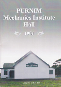
Booklet, Ron Best, Purnim Mechanics Institute Hall 1901, 2014
Brief history of Purnim Mechanics Institute HallThis is a paper back book of 24 pages. It has a white back cover and a grey/white front cover with a coloured photograph of the second Purnim Hall. The printed material is black on a white background. non-fictionBrief history of Purnim Mechanics Institute Hallpurnim, mechanics’ institutes, warrnambool