Showing 1505 items
matching bridge street bridge
-
 Orbost & District Historical Society
black and white photographs, C1970
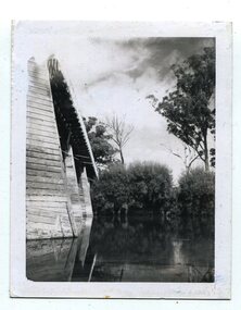
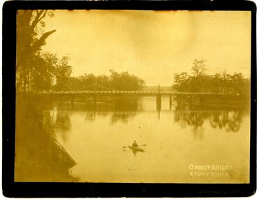
These photographs are of the 1922 road bridge across the Snowy River at Orbost. This bridge over the Snowy River was opened on July 4 1922. It was constructed in 1922 alongside the previous suspension bridge. Its building was a combined effort of the Victorian Railways and the Country Roads Board at a cost of 35,000 pounds. It was replaced in 1976 by the present bridge after several major floods.This bridge was replaced in 1976 after several major floods. These photographs are pictorial records of the 1922 brige.Two small black / white photographs of a road bridge across a river. 3248.1 is a close-up of wooden pylons.on label on back - "Snowy River Bridge at Orbost 1922 Bridge"bridge-orbost snowy-river-bridge -
 Orbost & District Historical Society
black and white photographs, 1937
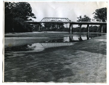
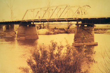
These photographs are of the bridge across the Snowy River at Orbost which was replaced in 1976. This bridge over the Snowy River was opened on July 4 1922. It was constructed in 1922 alongside the previous suspension bridge. Its building was a combined effort of the Victorian Railways and the Country Roads Board at a cost of 35,000 pounds. It was replaced in 1976 by the present bridge after several major floods.This bridge was replaced in 1976 after several major floods. This is a pictorial record of that bridge.Three black / white photographs of a truss bridge across a river.bridge-snowy-river orbost-bridge-1937 -
 Orbost & District Historical Society
black and white photograph, January 1934
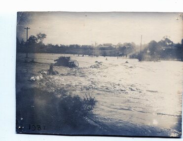
From The Argus (Melbourne) on January 10 1934 "Damage estimated at £500,000 has been caused by the floods in the Orbost district. No loss of life occurred, largely owing to the heroic efforts of rescue parties. Many families spent Monday night on the roofs of houses or in trees, surrounded by deep, rushing flood waters." This 1934 flood was devastating, destroying a section of the 1922 Orbost bridge - the centre span was washed away -. wrecking fences, bridges and roads, dumping silt and debris on the rich river flats and drowning cattle. This is a pictorial record of the 1934 flood, a significant event in the history of Orbost.A black / white photograph of floodwaters. In the middle of the water can be see debris including a large spoked wheel. In the background are houses and fences.on back - "near Hilyer's garage at foot of hill Main Street Caravan Park on right" on front at bottom left - "1934"orbost-flood-1934 flood-orbost -
 Orbost & District Historical Society
black and white photographs, January 1934
These are photographs taken during the 1934 flood at Orbost. From The Argus (Melbourne) on January 10 1934 "Damage estimated at £500,000 has been caused by the floods in the Orbost district. No loss of life occurred, largely owing to the heroic efforts of rescue parties. Many families spent Monday night on the roofs of houses or in trees, surrounded by deep, rushing flood waters." This 1934 flood was devastating, destroying a section of the 1922 Orbost bridge - the centre span was washed away -. wrecking fences, bridges and roads, dumping silt and debris on the rich river flats and drowning cattle.These photographs are pictorial records of the 1934 floods at Orbost, a significant event in the history of Orbost.Nine small black / white photographs of flood damage,3253.2 on back - "Waters rushing down Princes Highway and....of......where you see the waves" 3253.3 on back - "rushing flood waters over Lochiel Park Bridge approach at the rear of picture 1934"orbost-flood-1934 flood-orbost -
 Orbost & District Historical Society
black and white photographs, first half 20th century
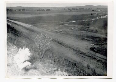
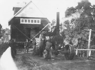
3255.1 is a photograph of the Princes Freeway construction of the roadway embankment at the foot of Newmerella Hill. 3255.2 is of the construction of the roadway, the Princes Freeway looking down from Newmerella toward Orbost. 3255.3 shows the Princes Freeway from Grandview , Newmerella, and shows the southern end of Ashby's Gulch with its bridge. 3255.4 is of the Princes Freeway showing the bridge across Ashby's Gulch and a train on the railway viaduct. Ashby's Gulch is named for the Ashby family. The Ashby family was one of the early settlers in Orbost at Newmerella. Roy Ashby, son of James Rowland Ashby and Edith Annie Hall, was born on 21 Nov 1892 in Orbost. Victoria. Australia and died in 1942 in Orbost. Victoria. Australia at age 50. Roy married Elsie May Stephens, daughter of James Stephens and Sarah Taylor, in 1920 in Victoria.Australia. Elsie was born on 15 Sep 1898 in Beaconsfield Tasmania.Australia and died in 1974 in Orbost Australia at age 76. Their children were: Roy Ashby, William Henry Ashby, Cordelia Valma Ashby and Edith Ashby. This photograph is associated with the construction of the main roads into Orbost. It is also connected to the Orbost to Bairnsdale Railway.Four black / white photographs of road construction and rail bridges.road-construction-newmerella princes-freeway-newmerella ashby's-gulch-newmerella orbost-railway -
 Orbost & District Historical Society
black and white photographs, 1975
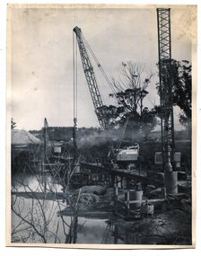
These are photographs of the construction of the current cement road bridge across the Snowy River at Orbost. Construction of the bridges commenced in January 1975, with an expectation to open the bridge across the Snowy River as soon as possible. Less than two years later, on 25 November 1976, the bridge across the Snowy River was opened to traffic, allowing the old bridge to be demolished. The remainder of the Orbost Bypass, both the floodplain crossings and the eastern section around the township itself, was declared ‘Princes Freeway’ and opened to traffic in December 1977. (ref http://mrv.ozroads.com.au)The opening of this Snowy River Bridge was an important development in the accessibility to the township of Orbost. These photographs record its construction.Two black / white photographs showing the construction of a road bridge across a river. 3257.1 shows piles being dropped beside the bridge, 3257.2 is of the early stages of construction of this bridge.snowy-river-bridge-orbost road-construction-orbost bridge-orbost -
 Orbost & District Historical Society
sheet music, Under the Bridges of Paris, first half 20th century
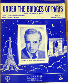
... Orbost & District Historical Society Ruskin Street Orbost ...Under the Bridges of Paris" is a 1913 popular song with music written by Vincent Scotto, the original French lyrics (entitled "Sous les ponts de Paris") by Jean Rodor (1913), and English sections of lyrics added by Dorcas Cochran (1952) resulting in the released version (1954) containing both French and English sections. This version of the song was recorded by Rene Paul.The music has social significance as an example of music popular in the first half of the 20th century.Sheet music for "Under the bridges of Paris". The cover is blue with white illustrations of the Eiffel Tower and the Arc de Triomphe. In the centre is a head and shoulders photograph of a man in a suit and tie. It is captioned "Recorded by Rene Paul on Columbia." Under the title are details of the composer and lyricists. In the bottom right corner is the price 2/6.music-sheet under-the-bridges-of-paris -
 Orbost & District Historical Society
framed certificate, January 2003
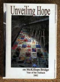
This certificate was presented at the East Gippsland Shire Council Australia Day celebrations on 26.1.2003. The veiling of McKillops bridge was a 'Year of the Outback' event. The event was organised by Orbost resident, Sr Helen Barnes RSJ. to show solidarity with rural people. The local community transformed the bridge into "a symbol of communal love and hope", when its sides were draped with hundreds of personal messages. McKillop's Bridge, located high in the Snowy Mountains, is named after George McKillop, a pioneering explorer of the area. The bridge is a vital link for isolated farming communities living beyond the Bonang highway. The Veiling of McKillops Bridge was a significant community event.A large framed certificate. An Australia Day Community Event certificate for January 2003. The frame is silver The certificate has white, green and blue print on a blue background.presented to "Veiling of McKillops Bridge on frame corner AMS by East Gippsland Shie Council signed by Cr P. Bommer (mayor)mckillops-bridge-veiling east-gippsland-shire-council-australia-day -
 Ringwood and District Historical Society
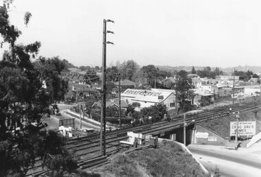
Photograph, View from Ringwood Clocktower overlooking Wantirna Road railway bridge and Thanet Street corner - Dec. 1969
... railway bridge and Thanet Street corner - Dec. 1969....Written on back of photograph: "Wantirna Rd bridge. from...: "Wantirna Rd bridge. from clocktower, 1969". Thanet Street corner ...Black and white photographWritten on back of photograph: "Wantirna Rd bridge. from clocktower, 1969". Thanet Street corner. -
 Ringwood and District Historical Society
Photograph, C of E jambed on bridge over Mullum Creek, W'dyte Rd. Ringwood 1924
Written on back of photograph, "C of E jambed on bridge over Mullum Creek, W'dyte Rd. 1924." Typed below another copy: "Moving Church of England, Ringwood. Stuck on bridge over Mullum Creek in Warrandyte Rd. 1924". Written on backing sheet, "Church of England being moved from C/r Pratt Street and Maroondah H'way to rear post office via Warrandyte Rd., Reynolds Av. and Ringwood Street." -
 Orbost & District Historical Society
photograph, first half of 20th century prior to 1976
Purchased from Orbost Op shop several years ago. Original owner unknown. This bridge over the Snowy River was opened on July 4 1922. It was constructed in 1922 alongside the previous suspension bridge. Its building was a combined effort of the Victorian Railways and the Country Roads Board at a cost of 35,000 pounds. It was replaced in 1976 by the present bridge after several major floods.This bridge was replaced in 1976 after several major floods.A wooden framed photograph of the second Snowy River bridge at Orbost.photograph snowy-river-bridge -
 Orbost & District Historical Society
album, Walcott, Judy, Unveiling Hope on McKillops Bridge, 2005
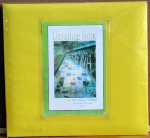
This album was donated to the Orbost & District Historical Society after the death of Judy Walcott, a long-time member. The veiling of McKillops bridge was a 'Year of the Outback' event. The event was organised by Orbost resident, Sr Helen Barnes RSJ. to show solidarity with rural people. The local community transformed the bridge into "a symbol of communal love and hope", when its sides were draped with hundreds of personal messages. McKillop's Bridge, located high in the Snowy Mountains, is named after George McKillop, a pioneering explorer of the area. The bridge is a vital link for isolated farming communities living beyond the Bonang highway.This album is a useful reference tool.A large photo album with a bright yellow cover and 19 plastic sleeves. It contains photographs, newspaper clippings, brochures , maps and an invitation to the veiling of McKillops Bridge on 8th August 2002. It also contains the history of McKillops Bridge.On inside cover - left hand side - "To Marie with Best Wishes from Judy Walcott 8/8/2005"mckillops-bridge album -
 Orbost & District Historical Society
folder, Orbost Bridges - Snowy River Road Bridges, 1974 1976
This folder was compiled in October 2015 from documents, magazines. papers and photographs donated by David Jellie, engineer in charge 1974 - 1976. In early 1974, as an Engineer with the Country Roads Board, David came to Orbost as the Supervising Engineer for the construction of the new bridges which were part of an 8.4km Orbost bypass road design. This was a major project involving not only a new bridge over the Snowy River (including Lochiel Lagoon), but other bridges over Ashby’s Gulch and Watt’s Gulch. These new bridges were opened in November 1976 with the unveiling of a plaque on the eastern end of the $2.4M Snowy River Bridge. (ref. May Leatch)This item is a useful reference tool on the construction history of the Snowy River Road bridges.A white plastic folder - Orbost Bridges - Snowy River Road Bridges. it contains newspaper articles, booklets, photographs and documents relating to the construction of the Snowy River Road Bridge in 1974 -1976.on front cover - 1974 - 76 ORBOST / SNOWY RIVER ROAD BRIDGES * construction * photos * articles * plans Donated by David Jellie Oct 2015snowy-river-bridges jellie-david -
 Orbost & District Historical Society
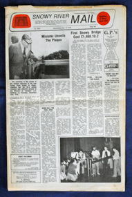
newspaper, Snowy River Mail, 1.12.1976
In early 1974, as an Engineer with the Country Roads Board, David came to Orbost as the Supervising Engineer for the construction of the new bridges which were part of an 8.4km Orbost bypass road design. This was a major project involving not only a new bridge over the Snowy River (including Lochiel Lagoon), but other bridges over Ashby’s Gulch and Watt’s Gulch. These new bridges were opened in November 1976 with the unveiling of a plaque on the eastern end of the $2.4M Snowy River Bridge. The new bridge, built by the CRB at a cost of $2.4 million, is 1.6 metres above the record flood levels of 1971. (ref. May Leatch) This newspaper contains contemporary reports of a significant event in Orbost.A Snowy River Mail newspaper, dated 1.12.1976. It contains news articles, photographs and advertisements. The main article relates to the official opening of the Snowy River Bridge and the unveiling of a plaque on the eastern approach. It also contains a history of the first Snowy River Bridge.snowy-river-bridge orbost-bridges snowy-river-mail -
 Orbost & District Historical Society
photograph, late 19th - early 20th century
Frank Richardson 1877-1950 was a sawmiller at Tabbara and helped build and run paddle steamer "Curlip"as engineer.This item is an early pictorial record of the old Snowy River bridge at Orbost.A large b/w photograph of the Snowy River bridge at Orbost. In the foreground there is a man in a small canoe with paddles. The photograph is pasted onto a black buff card. 2606.2 is a copy of the original used for display.On front : "Eastwood Bros, Bairnsdale, Orbost Bridge over Snowy River".photograph-snowy-river-bridge eastwood-bros -
 Orbost & District Historical Society
D.V.D, Jenkins, Daniel - Hot Dog Films, Unveiling Hope, 8.8.2002
As part of the Crelebration of the Year of the Outback, McKillop's Bridge in the Deddick Valley was hung with nineteen banners made by individuals and groups of East Gippsland. Banners containing thousands of messages of hope and optimism for the future of rural communities were suspended from he bridge in the Snowy River National Park, in front of a three hundred strong crowd that had assembled. Sister Helen Barnes from the Sisters of St Joseph Order, founded by Mary McKillop, initiated the project. This event was a significant event in local history and this item is a contemporary recording of it.A D.V.D. titled, Unveiling Hope. On the front is a coloured photograph of McKillop's Bridge in the Deddick Valley.mckillop's-bridge banners-of-hope -
 Marysville & District Historical Society
Postcard (item) - Colour photographs, Murray Views, Marysville 12 Views, 1950's
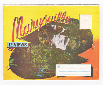
A fold out postcard of 12 colour photographs of scenes and landscapes in and around Marysville in Victoria.A fold out postcard 12 colour photographs of scenes and landscapes in and around Marysville in Victoria. These photographs were produced by Murray Views in Gympie, Queensland as a souvenir of Marysville.Marysville/ 12 VIEWS PRODUCED BY MURRAY VIEWS./ GYMPIE./ Q COPYRIGHT SAMUEL LEE & CO., PRINTERS. STEAVENSON'S FALLS, MARYSVILLE, VIC. TOURISTS AT MARYSVILLE, VIC. "FRUIT SALAD FARM", MARYSVILLE MAIN STREET, MARYSVILLE, VIC. ROAD SCENE, MARYSVILLE, VIC. THE CROSSWAYS, MARYSVILLE, VIC ROAD TO CUMBERLAND VALLEY, MARYSVILLE PANORAMA FROM BLACK SPUR, MARYSVILLE ROAD, MARYSVILLE, VIC. NICHOLL'S LOOKOUT, MARYSVILLE, VIC. TREE FERNS, MARYSVILLE, VIC. THE BRIDGE, MARYSVILLE, VIC.steavenson falls (image 1), tourists in marysville (image 2), taggerty river (image 3), fruit salad farm (image 4), main street marysville (image 5), road scene marysville (image 6), the crossways (image 7), cumberland valley (image 8), black spur (image 9), nicholl's lookout (image 10), tree ferns (image 11), bridge (image 12), marysville, victoria, postcard, souvenir, murray views -
 Marysville & District Historical Society
Postcard (item) - Colour photographs, Murray Views, Marysville 12 Views, 1950's
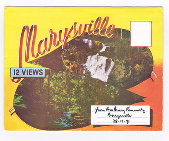
A fold out postcard of 12 colour photographs of scenes and landscapes in and around Marysville in Victoria.A fold out postcard 12 colour photographs of scenes and landscapes in and around Marysville in Victoria. These photographs were produced by Murray Views in Gympie, Queensland as a souvenir of Marysville.Marysville/ 12 VIEWS from Mrs Mary Keneally/ Marysville/ 28.11.91 PRODUCED BY MURRAY VIEWS./ GYMPIE./ Q COPYRIGHT SAMUEL LEE & CO., PRINTERS. STEAVENSON'S FALLS, MARYSVILLE, VIC. TOURISTS AT MARYSVILLE, VIC. "FRUIT SALAD FARM", MARYSVILLE MAIN STREET, MARYSVILLE, VIC. ROAD SCENE, MARYSVILLE, VIC. THE CROSSWAYS, MARYSVILLE, VIC ROAD TO CUMBERLAND VALLEY, MARYSVILLE PANORAMA FROM BLACK SPUR, MARYSVILLE ROAD, MARYSVILLE, VIC. NICHOLL'S LOOKOUT, MARYSVILLE, VIC. TREE FERNS, MARYSVILLE, VIC. THE BRIDGE, MARYSVILLE, VIC.steavenson falls (image 1), tourists in marysville (image 2), taggerty river (image 3), fruit salad farm (image 4), main street marysville (image 5), road scene marysville (image 6), the crossways (image 7), cumberland valley (image 8), black spur (image 9), nicholl's lookout (image 10), tree ferns (image 11), bridge (image 12), marysville, victoria, postcard, souvenir, murray views -
 Marysville & District Historical Society
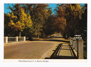
Postcard (item) - Colour postcard, Nucolorvue Productions Pty. Ltd, Pack Road from F.J. Barton Bridge, Pre 2009
... A colour photograph of Murchison Street from the F.J...A colour photograph of the F.J. Barton Bridge looking up... of Murchison Street from the F.J. Barton Bridge in Marysville ...A colour photograph of Murchison Street from the F.J. Barton Bridge in Marysville in Victoria.A colour photograph of Pack Road from the F.J. Barton Bridge in Marysville in Victoria. Labeling is incorrect. The view is looking down Murchison Street from the F.J. Barton Bridge. The F.J. Barton Bridge was named after Frederick John Barton. The Barton Family were amongst Marysville's first pioneering families. This postcard was published by Nucolorvue Productions as a souvenir of Marysville.NU-COLOR-VUE/ OF / AUSTRALIA MARYSVILLE, VICTORIA. Pack Road from F.J. BARTON/ BRIDGE. PLACE/ STAMP/ HERE POST CARD NCV.172 - NUCOLORVUE PRODUCTIONS PTY. LTD./ COPYRIGHT Printed in Australiamarysville, f.j. barton bridge, murchison street, victoria, postcard, souvenir, nucolorvue productions, fj barton -
 Marysville & District Historical Society
Photograph (item) - Colour photograph, 15-11-03
A colour photograph of a bridge that leads to Big Tree near Cambarville in Victoria.A colour photograph of a bridge that leads to Big Tree near Cambarville in Victoria. It was, at one stage, known to be the tallest hardwood tree in the world standing at 92 meters (301ft, 6 inches). However, it was reduced to 84 meters by a wind storm in 1959. It is a mountain ash. There is a walking track through the forest to the Big Tree.A weekend at Marysville 15-11-03 Catherine Pat Natasha & Normabig tree, mountain ash, cambarville, victoria, photograph -
 Marysville & District Historical Society
Document (Item) - Document-Table, Judith Vimpani, Yarra Track Hostelries- Marysville to Woods Point, Unknown
A document outlining all the hostelries that existed along the Yarra Track between Marysville and Wood's Point.A document outling all the hostelries that existed along the Yarra Track between Marysville and Wood's Point.yarra track, marysville, wood's point, woods point, fernshaw, paradise plains, black spur, mount grant, george edwards, walker family, melbourne, new chum, hit & miss restaurant, mr clifford, michael woods, glen watts, tri bhean hotel, ewen cameron, ewen hugh cameron, thomas barton, butler's wood's point directory, globe hotel, swanston street, mount juliet, ben more & c, jordan district, jefferson's watts bridge inn, matthew jefferson, reefer's hotel, boyle's hotel, william henry johnson, samuel boyle, black spur hotel, fisher's creek, narbethong, fisher's home hotel, black spur inn, frederick fisher, william hodson, wood's point road, acheron river, acheron bridge hotel, john robson, granton, clifford, wilks creek, wilks creek hotel, patrick maloney, steavenson, marysville hotel, australian hotel, junction hotel, the dutchman's restaurant, henry kuyper, william podlech, mount arnold, mount arnold hotel, charles schultz, james toohey, john gleeson, joy burchall, ian newman, henry brockman, belle isle, belle elle, bellell creek, upper yarra, guerin's bridge, bell's hotel, henry petty, celia moran, ruth petty, cumberland creek, cumberland creek store and restaurant, cumberland creek hotel, charles edwin hargreaves, annie hargreaves, urina hargreaves, alice hargreaves, healesville, josiah hargreaves, henderson drysdale, henry whelan, halfway house, thomas smith, svendson, gosling, donovans creek, chesterville, perry's hotel, john perry, perry's coach and horses hotel, edward courtney, scandinavian hotel, the swede's, walker's hotel, jacob burchart, golden fleece, theodore kappler, george koehler's hotel, david walker, millicent walker, elsie jowett, bill walker, big river, royal mail hotel, shaw's, slingsby davies, edwin jones, elizabeth jane parker, sandridge, archibald charles edwin jones, matlock, alexander myers, frank berwick frederick jones, ned jones, jennie jones, sophie milllicent parker jones, thomas shaw, dorothy walker, travellers rest hotel, reefton, summers, john fehring, f fehring, katerina fehring, john christoph blumeyer, anne fehring, john baker, evelyn observer, anna katrina baker, hannah catherine baker, john frederick baker, mcmahon's creek, oaks, the springs, st clair, sinclair's valley, mountain home hotel, neilson, collins, waters, jan emma sinclair, john sinclair, mr cox, peter sinclair, willie we have missed you hotel, spring vale hotel, robert matthews, thomas crawford -
 Marysville & District Historical Society
Photograph (Item) - Black and white photograph, Bridge Over The Cumberland, c1900
An early black and white photograph of a bridge over the Cumberland Creek near Marysville in Victoria.An early black and white photograph of a bridge over the Cumberland Creek near Marysville in Victoria. The Cumberland Creek is in the Cumberland Valley near Cambarville which was a timber town near Marysville. Cambarville is notable for its giant mountain ash (Eucalyptus regnans) trees within the Cumberland Memorial Scenic Reserve, and relics from former sawmills and gold mining. The Big Culvert is located nearby on the Marysville - Woods Point Road, which was historically part of the Yarra Track. Cambarville was established as a timber mill town in the 1940s. Timber mill owners A Cameron and FJ Barton named Cambarville. They established the mill to salvage timber from trees destroyed in the 1939 bushfires. Cambarville was impacted by the 2009 Black Saturday bushfires and any remaining structures were destroyed.ARMSTRONG COLLECTION 42 STATION STREET/ SANDRINGHAM 3191/ TEL. (03) 9521 5442/ IAN M.L. ARMSTRONG OAMcumberland creek, marysville, victoria, cumberland valley, cambarville, mountain ash, eucalyptus regnans, cumberland memorial reserve, the big culvert, marysville-wood's point road, yarra track, a cameron, fj barton, 2009 black saturday bushfires -
 Marysville & District Historical Society
Booklet - Information booklet, Ann Thomas, Wilks Creek Bridge, 1993
A history of the Wilks Creek Bridge and its connection to the Yarra Track.Paperback. Front cover has an old photograph of the Wilks Creek Bridge.non-fictionA history of the Wilks Creek Bridge and its connection to the Yarra Track.wilks creek bridge, yarra track, narbethong, marysville, victoria, clement wilks, wood's point goldfields, jordan goldfields, john monash, monash and anderson, 2009 black saturday bushfires -
 Marysville & District Historical Society
Photograph (Item) - Colour photograph, Pre 2009
A colour photograph of the Wilks Creek Bridge near Marysville in Victoria.A colour photograph of the Wilks Creek Bridge near Marysville in Victoria. The Wilks Creek Bridge is a former timber and bluestone road bridge on the Yarra Track, and is located just off the Black Spur route, between Narbethong and Marysville, Victoria, Australia. It was built in 1870 to the design of colonial Public Works Department engineer Clement Wilks as part of the construction of a new road to the Woods Point and Jordan Goldfields. Like many bridges of the period, it had a timber superstructure employing squared beams supported by struts and straining pieces, on cut bluestone abutments. The bridge was remodelled around 1900 by engineer John Monash of the famous bridge-engineering firm of Monash and Anderson. It was last used for heavy vehicular traffic in 1980 following the realignment of Marysville Road, and was left to decay until its demolishment in 2008. All timber traces of the bridge were destroyed in the 2009 Black Saturday fires. The handcrafted bluestone masonry wingwalls and abutments, especially shaped to receive timber struts, rate among the earliest of its kind surviving intact in Victoria.wilks creek bridge, yarra track, narbethong, marysville, victoria, clement wilks, wood's point goldfields, jordan goldfields, john monash, monash and anderson, 2009 black saturday bushfires -
 Marysville & District Historical Society
Photograph (Item) - Black and white photograph, 1993
A black and white photograph taken at the re-opening of the Wilks Creek Bridge picnic area and launch of Ann Thomas' book Wilks Creek Bridge.A black and white photograph taken at the re-opening of the Wilks Creek Bridge picnic area and launch of Ann Thomas' book Wilks Creek Bridge. The Wilks Creek Bridge is a former timber and bluestone road bridge on the Yarra Track, and is located just off the Black Spur route, between Narbethong and Marysville, Victoria, Australia. It was built in 1870 to the design of colonial Public Works Department engineer Clement Wilks as part of the construction of a new road to the Woods Point and Jordan Goldfields. Like many bridges of the period, it had a timber superstructure employing squared beams supported by struts and straining pieces, on cut bluestone abutments. The bridge was remodelled around 1900 by engineer John Monash of the famous bridge-engineering firm of Monash and Anderson. It was last used for heavy vehicular traffic in 1980 following the realignment of Marysville Road, and was left to decay until its demolishment in 2008. All timber traces of the bridge were destroyed in the 2009 Black Saturday fires. The handcrafted bluestone masonry wingwalls and abutments, especially shaped to receive timber struts, rate among the earliest of its kind surviving intact in Victoria.wilks creek bridge, yarra track, narbethong, marysville, victoria, clement wilks, wood's point goldfields, jordan goldfields, john monash, monash and anderson, 2009 black saturday bushfires -
Marysville & District Historical Society
Document (Item) - Heritage Report, Biosis Research Pty Ltd, Heritage Report-Dismantling of Wilks Creek Brdige Deck Marysville, Unknown
A heritage report on the dismantiling of the Wilks Creek Bridge deck in Marysville in Victoria.A heritage report on the dismantiling of the Wilks Creek Bridge deck in Marysville in Victoria. The Wilks Creek Bridge is a former timber and bluestone road bridge on the Yarra Track, and is located just off the Black Spur route, between Narbethong and Marysville, Victoria, Australia. It was built in 1870 to the design of colonial Public Works Department engineer Clement Wilks as part of the construction of a new road to the Woods Point and Jordan Goldfields. Like many bridges of the period, it had a timber superstructure employing squared beams supported by struts and straining pieces, on cut bluestone abutments. The bridge was remodelled around 1900 by engineer John Monash of the famous bridge-engineering firm of Monash and Anderson. It was last used for heavy vehicular traffic in 1980 following the realignment of Marysville Road, and was left to decay until its demolishment in 2008. All timber traces of the bridge were destroyed in the 2009 Black Saturday fires. The handcrafted bluestone masonry wingwalls and abutments, especially shaped to receive timber struts, rate among the earliest of its kind surviving intact in Victoria.wilks creek bridge, yarra track, narbethong, marysville, victoria, clement wilks, wood's point goldfields, jordan goldfields, john monash, monash and anderson, 2009 black saturday bushfires -
 Marysville & District Historical Society
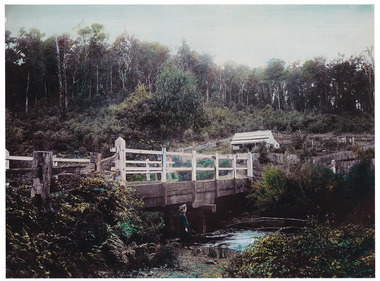
Photograph (Item) - Colour tinted photograph, 1878-1904
A copy of an early colour tinted photograph of a wooden bridge in Marysville in Victoria.A copy of an early colour tinted photograph of a wooden bridge in Marysville in Victoria. This photograph was taken by Nicholas John Caire between 1878 and 1904. Nicholas John Caire was born in 1837 in Guernsey. He arrived in Adelaide about 1860 along with his parents who encouraged his early interest in photography. He opened a studio in Adelaide in 1867 after traveling extensively throughout the Gippsland taking photographs. After marrying in 1870 he moved to Talbot in Victoria until 1876 when he opened a studio in the Royal Arcade in Melbourne. After 1885 Nicholas John Caire gave up his city work and made his home in South Yarra and devoted the rest of his life to outdoor photography, specializing in the bush, the gullies, and the mountains of south-eastern Victoria. nicholas john caire, marysville, victoria