Showing 3152 items matching "miles"
-
 National Wool Museum
Medicine bottle
Collection originally owned by Strauss family of Waverley Rainbow (on road to Lake Albaculya, 12 miles from Rainbow).SPIRIT OF CAMPHOR (label) -
National Wool Museum
Medicine bottle
Collection originally owned by Strauss family of Waverley Rainbow (on road to Lake Albaculya, 12 miles from Rainbow).Asprin (label) -
National Wool Museum
Medicine bottle
Collection originally owned by Strauss family of Waverley Rainbow (on road to Lake Albaculya, 12 miles from Rainbow).CALOMEL (label) -
 National Wool Museum
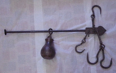
Steelyard
Steelyard used for weighing wool and wheat on "Moor Park" on Yarriariak Creek, twenty miles from Horsham, Victoria.Steelyard used for weighing wool and wheat on "Moor Park" on Yarriariak Creek.sheep stations management, wool growing, hamilton, mr robert g, sheep stations - management -
 Port Fairy Historical Society Museum and Archives
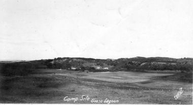
Photograph, 1918
Goose Lagoon Campsite 1918 A post card of the area a few miles from Port Fairy near BoodcarraBlack and white Photograph of Goose Lagoon campsite.Campsite Goose Lagoon 1918 WRBtgoose lagoon, campsite, post card, port fairy, grassland, swamp -
 Charlton Golden Grains Museum Inc
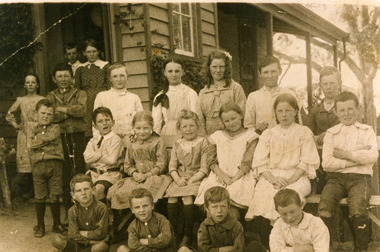
Photograph - Teddywaddy State School, c. early 1900s
The first site of school no. 2064 was on Glenloth Road, one mile from Fig Tree corner on Calder Highway.Sepia photograph of pupils in front of Teddywaddy State School No. 2064, early 1900s. L to R. Pupils Back Row. M Jolly, K Thompson, C Sait, G Jolly, W Sait. Middle Row. ?, L Sait, D Churchill, E Sait, E Sait, D Sait. Front Row. ?, ?, N Sait, J Sait. Infront of door.?, H Curnow, ?, L Thompson, H Sait.school, education, charlton -
 Ballan Shire Historical Society
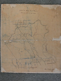
Map - Map. Bullarook State Forest, Bullarook State Forest Reserve
A small map of the Bullarook State Forest Reserve. Drawn on a fine buff coloured paper attached to a stiff cloth backing sheet. The title is hand written and includes a "scale one mile to one inch" hand written also. The map is signed "John Wrigglesworth, assistant ? and dated 26/6/1869" although the month and year are almost illegible.moorabool west, state forest, bullarook, eastern moorabool river, werribee river, moorabool east, blakes saw mill, wombat, andersons saw mill -
4th/19th Prince of Wales's Light Horse Regiment Unit History Room
Radio Set RS 510, AWA, 1957
Equipment used by the RegimentManpack portable HF transmitter/receiver consisting of two main units mounted in webbing pouches (worn in place of 1937 pattern infantry basic pouches). Crystal controlled radio for use in areas where VHF radio not viable, eg jungle. Operating range 3 to 5 miles The radio and all equipment comes in a wooden transit caseTransmitter No 885, Receiver No 885 radio, manpack, awa, 510 -
 Anglesea and District Historical Society
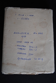
Map, Royal Australian Survey Corps, Anglesea, Victoria, 1954
Anglesea, Victoria [cartographic material] produced by Royal Australian Survey Corps. Colour; Scale [1:63,360] 1 mile to 1 inch; transverse Mercator projection; Sheet No. 866, Zone 7. Two stamps: 1. Rankine and Dobbie Pty Ltd. 2. Authorised for sale / Price 2/- / By Department of the Army Original date: November 1928.(See above)anglesea map, topographic map -
 Old School House Museum
Photograph
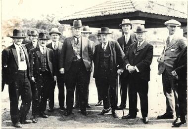
Group of men in front of a picnic shelter, known men are from left to right: 1.Frank Wells, 2. Dan Hoban, 3. J.A.P Ham (Town Clerk), 4. William Oates, 5. Minister from Melbourne, 6. Armstrong, 7. ?, 8.Alden, 9.Jack or Bill Pratt, 10. Mr keast ?, 11.Rowell Miles -
 Ballarat Tramway Museum
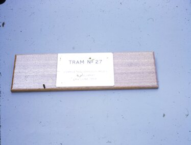
Slide - 27 mm sq slide/s - 27 plaque for one million miles, Lilian Butler, Apr. 1974
Yields information about the appearance of the million mile sign after it had been removed from the tram following closure and before return to the tram through the BTPS.Colour 27 x 27 mm slide in a white Kodak cardboard mount of the sign that was fitted that was fitted to tram 27, recording it had done one million miles in Ballarat (see Reg Items 6427 and 6428 for background and subsequent donation of the sign to the Museum). Slide mount dated April 97 Photo from the collection of Lilian Butler.ballarat, tramways, trams, signs, million miles, plaques, btps, tram 27 -
 Ballarat Tramway Museum
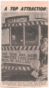
Newspaper, The Courier Ballarat, "A top attraction", 24/04/1973 12:00:00 AM
Newspaper clipping from The Courier, 24/4/1973 of a photo of tramcar 27 at the Museum site (BTPS) on display with three children at or near the doorway. Tramcar on the dash panel has the sign "This tram has just completed 1,000,000 miles in Ballarat" on the front apron. Captions notes children names as "Louise, Genevieve and David Hanzl" and mentions BTPS as an attraction.date in blue ink of "24/4/73" in top right hand corner of cutting.trams, tramways, btps, museum development, displays -
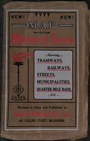 Melbourne Tram Museum
Map, Sands McDougall, Map of Melbourne and Suburbs showing Tramways, Railways, Streets, postal districts, Quarter-Mile Radii etc", c1919
Shows railways, cable and electric tram lines c1919. One of a number of maps produced by Sands McDougall of Collins St. Includes the MTOCo zoo horse tram lines, the PMTT, HTT and MBCTT lines, but not the FNPTT or the FTT lines. See items 2885 and 6573 for other editions. Yields information about Melbourne c1919 and its public transport lines. Produced by Sands and McDougall Pty Ltd of Collins St Melbourne. folded sheet of paper 6 sections wide x 6 sections or folds deep contained within a brown paper cover titled "Map of Melbourne and Suburbs showing Tramways, Railways, Streets, postal districts, Quarter-Mile Radii etc", showing both cable and electric tramways. maps, melbourne, cable trams, tramways, railways, horse trams, nmetl, vr trams, sands mcdougall, mbctt, pmtt, htt, zoo horse tramway -
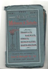 Melbourne Tram Museum
Map, Sands McDougall, Map of Melbourne and Suburbs showing Tramways, Railways, Streets, postal districts, Quarter-Mile Radii etc", c1922
Shows railways, cable and electric tram lines c1922. One of a number of maps produced by Sands McDougall of Collins St. Includes the Zoo horse tram lines. See acquisition and Research note by Duncan McAuslan. See items 2885, 6573, amd 6917 for other editions. On inside cover has current postal rates (including a war surcharge) and places worth visiting and on the rear cover, is an advertisement for Imperial ink.Yields information about Melbourne c1922 and its public transport lines. Produced by Sands and McDougall Pty Ltd of Collins St Melbourne. Folded sheet of paper 6 sections wide x 6 sections or folds deep contained within a green paper cover titled "Map of Melbourne and Suburbs showing Tramways, Railways, Streets, postal districts, Quarter-Mile Radii etc", showing both cable and electric tramways. maps, melbourne, cable trams, tramways, railways, horse trams, vr trams, sands mcdougall, zoo horse tramway, mmtb -
 Ringwood and District Historical Society
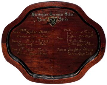
Plaque - Shield, Winnington Grammar School House Shield 1931 and 1932, Circa 1931
Wooden Shield with winning house and captains for 1931-2 Winnington Grammar School House Shield 1931 Term II Ruskin House Captain - June Miles Term III Ruskin House Captain - June Miles 1932 Term I Ruskin House Captain Marjorie Palmer 1932 Term II Browning House Captain - Helen Newell Ruskin House Captain - Marjorie Palmer Term III Singleton House Captain Joyce Covell -
 Ringwood and District Historical Society
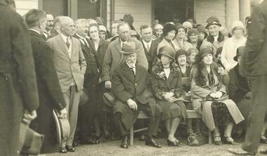
Photograph, Ringwood Bowls Club opening - 1931
Black and white photograph (2 copies- 1 large, 1 postcard size)Image shows a group of attendees including the following personalities: "Man in light suit LHS Horace Fenton, Headmaster Ringwood School and behind with moustache Mr. Gray, school inspector. RHS Herman Pump with watch chain. Captain E.T. Miles seated, directly behind him his son A.T. Miles. Mrs. Cooper is the lady in second row between the two ladies seated in front". -
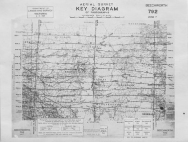 The Beechworth Burke Museum
Photograph - Aerial Survey, 5/9/1947
This image is an Aerial Survey, Key Diagram of Beechworth and surrounding area. Issued by Department of Lands and Survey, Victoria in 1947. Photographed at an average height of 12300 feet above sea level, areas depicted are; Beechworth, Stanley, Bruarong, Baranduda, Muagegonga, Myrtleford, Everton, Wooragee North Tarrawinge, Dederang, Kergunyah North, Kergunyah, Yackandandah, El-Dorado, Barambogie, Murmungee, Barwidgee, Oxley, CarraragarmungeeBlack and white rectangular photograph. Image is printed on matt photographic paper and has a white un-printed border. Obverse: AERIAL SURVEY, KEY DIAGRAM OF PHOTOGRAPHS, APPROXIMATE SCALE OF MILES / DEPARTMENT OF LANDS AND SURVEY VICTORIA 5.9.1947. BEECHWORTH 792 ZONE 7. Reverse: BMM7010.1 (written in pencil) aerial survey, beechworth, burke museum, department of lands and survey, victoria, 1947 -
 Ringwood and District Historical Society
Photograph, The old Ringwood Baths in Ringwood St. 1971
Black and white photographTyped below photograph, "The old Ringwood Baths in Ringwood St. 1971" Written on back of photograph, "Ringwood baths, Ringwood Street, between Miles Ave and Reynolds Ave 1971. -
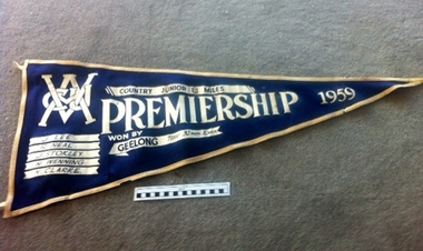 Geelong Cycling Club
Pennant Flag, 1959
Juniors in 1950s were important in the Club. In 1959, the year after the death of R. Mockridge, amateurs were in ascendancy after the Olympic Games in Melbourne in 1956. J. Lee had been a schoolboys winner. Record of the importance of Juniors to a strong cycling club.Triangular pennant in navy blue felt. The pennant has a border of white felt and details of the event and the competitors are embossed in white over the blue felt."VACU/Country Junior 13 Miles Premiership 1959/Won by Geelong/Time 32mins 15secs/J Lee/R Neal/J Stokley/N Wenning/N Clarke"vacu; country junior 13 miles; premiership 1959; j. lee; r. neal; j. stokley; n. wenning; n. clarke; -
 Wodonga & District Historical Society Inc
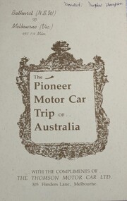
Booklet - The Pioneer Motor Car Trip of Australia, The Thomson Motor Car Ltd, 1900
Sixteen page booklet published and distributed by the Thomson Motor Car Co. Ltd of Melbourne in 1900, to record the first overland journey by a motor vehicle in Australia. The steam car driven by its inventor and builder Herbert Thomson and his cousin Edward Holmes travelled from Bathurst NSW to Melbourne between 30 April and 9 May 1900 (790 km) in 56 hours of actual driving. Holmes' notes on the trip are recorded in this booklet which was intended to publicise the firm and its new 'Light Model' steam car. The booklet includes photographs and illustrations.Sixteen page booklet published and distributed by the Thomson Motor Car Co. Ltd of Melbourne in 1900, to record the first overland journey by a motor vehicle in Australia. The steam car driven by its inventor and builder Herbert Thomson and his cousin Edward Holmes travelled from Bathurst NSW to Melbourne between 30 April and 9 May 1900 (790 km) in 56 hours of actual driving. Holmes' notes on the trip are recorded in this booklet which was intended to publicise the firm and its new 'Light Model' steam car. The booklet includes photographs and illustrations.pioneer motor vehicle, herbert thomson, overland travel australia, bathurst to melbourne, steam cars, thomson motor car co. ltd -
 Eltham District Historical Society Inc
Folder, Eltham Heritage Walks, 2006
Copy of notes for the Eltham Heritage Walk, 1989 compiled by Russell Yeoman and Heritage Mile, 2006 compiled by Ken Eckersall12 pagesHG Booklet 53harry gilham collection, heritage trail, heritage walk -
Phillip Island and District Historical Society Inc.
Newspaper clippings
Photographs of sinking of Harbour Trust Dredge "George Kermode" to form an artificial reef a mile south-east of Pyramid Rock.Photographs of sinking of Harbour Trust Dredge "George Kermode" to form a reeflocal history, documents, newspapers, newspaper clipping, dredges, black & white newspaper clipping, harbour trust dredge "george kermode" -
Bendigo Historical Society Inc.
Newspaper - JENNY FOLEY COLLECTION: POSE
The Inglewood Hospital was established in 1863. The need arose as previously patients had to travel 30 miles (48km) to Dunolly for treatment.Bendigo Advertiser '' The way we were'' from 2002. Pose: some of the staff at Inglewood Hospital, 1932. From left: R. Newton, V. Hancock, C. Meaney, Matron M. Lyons, I. Innes, M. McLyndon, M. Donaldson and J. Newton. The clip is in a folder. (18 March 2021 The copy of this item was not present in the folder and therefore cannot be recorded against this catalogue sheet).newspaper, bendigo advertiser, the way we were -
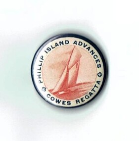 Phillip Island and District Historical Society Inc.
Badge, Badge - Phillip Island Advances Cowes Regatta
In March 1935, to celebrate the centenary of Melbourne, a 12 mile yacht race was held off Cowes. It was won by J. Walton on the Mayflower.HistoricalSmall round metal badge with white background. Dark writing around edge and drawing in red of a yacht sailing in centre. Pin on back.Phillip Island Advances Cowes Regattayacht race, j. walton, sampbell, kennon, grayden -
 Bendigo Military Museum
Photograph - Royal Australian Survey Corps Surveyors in the Field – North Queensland and Torres Strait, 1961
This is a set of five photographs of surveyors and support staff in the field undertaking duties in North Queensland and Torres Strait in 1961. The surveyors were employed in the establishment of mapping and geodetic control. In this era surveyors used theodolites to observe horizontal and vertical angles and tellurometers to measure base line distances between survey stations. In photo .2P Joe Farrington is seen taking survey observations using a Tavistock V500 Series Tavistock theodolite at a survey station between the Edward River and Aurukun in the Cape York Peninsula. The Gulf of Carpentaria appears in the background. From 1957 helicopter transport of survey parties revolutionised transport in remote areas. The civilian helicopter was hired from TAA. This is a set of five photographs of surveyors and support staff in the field undertaking duties in North Queensland and Torres Strait in 1961. The photographs were printed on photographic paper and are part of the Army Survey Regiment’s Collection. The photographs were scanned at 300 dpi. .1) - Photo, colour, 1961. Andy Millar occupying a survey station on a hill in the Cape York Peninsula, QLD. .2) - Photo, colour, 1961. Joe Farrington taking observations with a V500 Series Tavistock geodetic theodolite at a survey station in the Cape York Peninsula, QLD. .3) - Photo, colour, 1961. Daryl Parker taking a break from survey observations on a hill located on Duaun Island QLD, in the Torres Strait, a few miles south of the PNG coastline. Hill height was 975 ft. .4) - Photo, colour, 1961. Three Torres Strait divers L to R: unidentified, Darku and Ray Mau Daryl standing behind a Tavistock geodetic theodolite on a hill located on Duaun Island QLD, in the Torres Strait, a few miles south of the PNG coastline. .5) - Photo, colour, 1961. Andy Millar holding meat from a small turtle on Duaun Island QLD, in the Torres Strait, a few miles south of the PNG coastline. An unidentified Duaun Island local appears in the background..1P to .5P annotated on back – personnel names, the year and the location. royal australian survey corps, rasvy, army survey regiment, asr, army svy regt, fortuna, surveying -
 Ringwood and District Historical Society
Photograph, Maroondah Highway Central, Ringwood. Ringwood Coffee Palace, 1918
Black and white photograph (2 copies- 1 large, 1 small)Written on rear of backing sheet of large image: "Ringwood Coffee Palace (With Ringwood P.O. on left). Typed on back of small copy: "A.E. Walker arrived in Ringwood in 1910 from Gembrook. Bought land and erected shop. In Oct.1913 he sold out to Capt Miles who had erected Coffee Palace on each side of shop. Then rented shop from Miles. Shop later run by Beilby. -
 Ringwood and District Historical Society
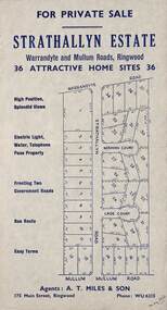
Flyer, Land Sale Advertisement - Strathallyn Estate, Ringwood, Victoria - circa 1950
Advertisement for private sale of 36 home sites in the Warrandyte Road and Mullum Mullum Road area of Ringwood, with map showing layout of subdivision and summary of local features and services. Handwritten notation indicates May, 1950.Subdivision includes Warrandyte Road, Strathallyn Road, Norman Court, Lade Court, and Mullum Mullum Road. Agents: A.T. Miles & Son, 175 Main Street, Ringwood, Phone WU6215. -
 Ringwood and District Historical Society
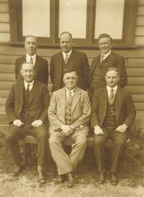
Photograph, Ringwood Borough Council - 1931
Written on back of black and white photograph, "Ringwood Borough Council - 1931. Standing left to right: J. McCaskill, J.G. Aird, R.W. Davies. Sitting: A.T. Miles, A. Blood, A. Ibbotson". -
 City of Greater Geelong
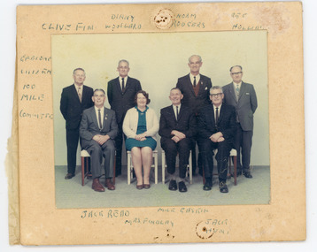
Photograph - Colour Photograph, Group, c1970
Members of Geelong Amateur Cycling ClubColour photograph mounted on cardboard. Eight people standing and sitting for a group photoOn upper - 'Clive Fin, Dinny Woolard, Norm Rodgers, Reg Holliday.' On left - 'Geelong 100 mile committee.' On bottom - 'Jack Reid, Mrs Findlay, Mick Gaskin, Jack Hunt'clive finn, dinny woolard, norm rogers, reg holliday, jack reed, mrs j findlay, alan gaskin, jack hunt -
 Bendigo Historical Society Inc.
Document - ANCIENT ORDER OF FORESTERS NO. 3770 COLLECTION: CORRESPONDENCE
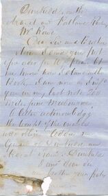
Letter to Mr. Rowe mentioning he sent a PO Order for 10/- and to let him know how he stood on the book. He also mentions that in his last note he was 200 miles from Melbourne. He would like a letter acknowledging receipt. He also says to address him as Guard of Dunkuld and Ararat ?, Dunkuld. Signature missing.societies, aof, correspondence, ancient order of foresters no. 3770 collection - correspondence, mr rowe, dunkuld and ararat ?