Showing 16995 items
matching plenty-river
-
 Orbost & District Historical Society
newspaper clippings, April, May 1987
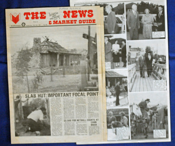
The Slab Hut (Orbost Visitor Information Centre) was opened on March 28, 1987. It was officially opened by Dr D. Caughey, the governor of Victoria. The Orbost Visitor Information Centre is situated in Forest Park on Nicholson Street. The centre is housed in the historic Slab Hut. The hut was an original family dwelling built in 1872, on a site approximately three kilometres upstream from the junction of the Buchan and Snowy Rivers. The Hut was removed from its original site around 1970, and stored until 1984 when the Shire Council approved the current site. It was restored and brought to life as a Tourist Information Centre in 1987.The Slab Hut is an icon of Orbost. These newspaper articles are contemporary records of the opening of this building.A selection of articles from The News and the Snowy River Mail. All relate to the opening of the Slab Hut, the Orbost Visitor Information Centre. They are photographs, information and the history of the Slab Hut.slab-hut-orbost newspaper-snowy-river-mail -
 Wodonga & District Historical Society Inc
Album - Ringer's River by Des Martin - Plate 32 - The shooting of Nugent
Advised of the tragedy by one of the stockmen Ellen O'Hara drives the gig towards Overton, but meets Klinberg who tells her the police have found a body near Nugent's place. Ellen gets there as Nugent is pulling Keiran's body from the river. Shock grief, and old bitternesses unhinge her mind. Seizing Trooper Ryan's pistol from on top of his clothes she shoots Nugent dead, and bolts up a rough back track towards her home with the police in pursuit. Her pony falls while belting along a narrow, dangerous piece of the track, and the gig goes over a cliff. Ellen is killed.The album and images are significant because they document literature written by a prominent member of the Wodonga community. The presentation of this precis was supported by several significant district families and individuals.Ringer's River Album Coloured photo Plate 32des martin, many a mile, ringer's river, northeast victoria stories -
 Greensborough Historical Society
Map, Melbourne and Metropolitan Board of Works. Survey Division, MMBW, Yarra 2500 / 13.23. Plenty, Middle Gorge, 1978_04
Melbourne and Metropolitan Board of Works. Yarra 2500 [base map] 13-23. Plenty / Middle Gorge. Parish of Morang 3183. Municipalities of Diamond Valley 257 and Whittlesea 239. Prominent streets include: Gorge Road, Kurrak Road and Browns Lane. Features include the Plenty River and Plenty Gorge Park.MMBW Map in 1:2500 [scale] series. Cream parchment with green tape reinforcing on edges and punched holes on left edge.mmbw, melbourne and metropolitan board of works, shire of diamond valley, plenty - maps, plenty gorge park -
 Wodonga & District Historical Society Inc
Album - Ringer's River by Des Martin - Plate 12 - A positive result from the customs duty
Meantime back at Camoola "Top Or Nothing" Price, known to stockmen as "Old Stop At Nothing", and his shifty ex-jockey clerk Billy Matthews, have been stunned by the Victorian customs duty of 30 shillings per head on cattle, and 50 shillings per head on horses, suddenly promulgated just prior to a very important sale. Caught with a lot of cattle he cannot unload, and a property sale that has gone astray, Price accepts offers for both from O'Day, who thus sets himself up cheaply with a good holding that runs down Barmagulla's back boundary to the Murray River at the point where he often swims across.The album and images are significant because they document literature written by a prominent member of the Wodonga community. The presentation of this precis was supported by several significant district families and individuals.Ringer's River Album Coloured photo Plate 12des martin, many a mile, ringer's river, northeast victoria stories -
 Greensborough Historical Society
Report, Examining Draughtsman's Report - Watts River Aqueduct, 20/07/1897
This Field Survey was commissioned by the Melbourne Board of Works and was used to position the Maroondah Aqueduct bridge north of Greensborough at its crossing point on the Plenty River. It incorporated the use of wrought iron water pipes and therefore is of lighter construction than other similar bridges in the district. It features a traverse of the Plenty RiverThe Maroondah Aqueduct bridge is a significant example of late 19th century engineering. A 4 page reproduction of an Office of Titles document. Copy of handwritten report includes maps.maroondah aqueduct, watts river aqueduct, bridge, greensborough, office of titles, 1897, wrought iron water pipes, plenty river, melbourne board of works -
 Lara RSL Sub Branch
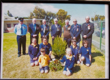
Framed Picture, Little River School Remeberance Day 2012, 2012
Dedication ceremony at the Little River Primary School for Rememberance Day 2012 RSL members from Left to Right were Walter Sherman, Ken Simmons, Snow Beswick, Bruce Challoner, Daryl Anderson, Alwyn Leech, Don ScownDedication Ceremony Rememberance Day 2012 Little River Primary SchoolFramed coloured photo in a plastic glass frame MDF backRear of Photo Frame " Little River School 12-11-2012 Remeberance Day Ceremonyphotograph little river primary rememberance day 2012 -
 Port Fairy Historical Society Museum and Archives
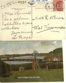
Postcard - post card, A.C. Aberline, Moyne Bridge & River Port Fairy, c.1900
A card sent to Miss R. Atkinson of West Warrnambool to add to her collection of postcardsHand coloured Photograph of the Moyne river road bridge, a domestic windmill in foreground and in the background large sheds made for use as a postcard with reverse side stamped Front:- Moyne bridge & river, port Fairy. Reverse:- aug.13/8/08- i hope this will be a welcome addition to your collection yours Sincerly, L Murphy - To Miss R Atkinson, West Warrnambool moyne bridge, moyne river, windmill -
 Port Fairy Historical Society Museum and Archives
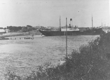
Photograph
This shows the S.S.Wannon turning in the specially widened part of the river called the "turning basin" before slipping into her berth at the Belfast and Koroit Steam Navigation Company wharfBlack and white photograph of SS Wannon turning in the Moyne Rivership, boat, sea, moyne river, belfast and koroit steam navigation company, turning basin -
 Greensborough Historical Society
Map, Melbourne and Metropolitan Board of Works. Survey Division, MMBW, Yarra 2500 / 12.24. Plenty and Blue Lake, 1977_10
Melbourne and Metropolitan Board of Works. Yarra 2500 [base map]. 12-24, Municipalities of Whittlesea 239 and Diamond Valley 257. Shows street names, easement sizes, lot numbers, lodged plan numbers, names of prominent features, contour values, creek or river names. Watsonia Railway Station and environs. Prominent streets: Memorial Drive. Includes Plenty River and Blue Lake in the Plenty Gorge.MMBW Map in 1:2500 [scale] series. Cream parchment with green tape reinforcing on edges and punched holes on left edge.mmbw, melbourne and metropolitan board of works, shire of diamond valley, plenty - maps, blue lake -
 Greensborough Historical Society
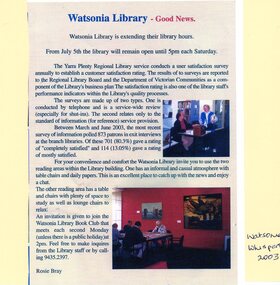
Article - Newspaper Clipping and Flyer, Watsonia Traders Association, Watsonia Library: Good News: Watsonia Library is extending their library hours, 05/07/2003
Watsonia Library extends Saturday opening hours in July 2003. Newspaper clipping from Watsonia's Whisper and flyer from Yarra Plenty Regional Library (YPRL) inviting patrons to the opening celebrations.News article. Black, red and blue text and colour image on colour background. yarra plenty regional library, yprl, watsonia library -
 Eltham District Historical Society Inc
Photograph, Amberley, Lower Plenty; Autumn Excursion to Lower Plenty area, 18 April 1998, 18/04/1998
Looking westerly across the Yarra from Westerfolds Park you can see a large and imposing building at the top of the escarpment above the river. This is the Christian Brothers Training Centre at Lower Plenty and known as Amberley. This significant building dates from 1930 when it was the rather grand residence of Oswald Darch. It was purchased by the Catholic Church in 1955 and has since been significantly extended.Roll of 35mm colour negative film, 2 stripsKodak Gold 200-6activities, lower plenty, amberley -
![Waterfall Scene on the Coliban River, near Elphinstone / [by] Nicholas Caire, circa 1876](/media/collectors/550653872162f11fb04854aa/items/577b4d42d0cdd10948c96acf/item-media/577b4dbfd0cdd10948c9b34f/item-fit-380x285.jpg) Kew Historical Society Inc
Kew Historical Society IncPhotograph, Anglo-Australasian Photographic Company, Waterfall Scene on the Coliban River, near Elphinstone, c. 1876
Nicholas Caire was born on Guernsey in the Channel Islands in 1837. He arrived in Adelaide with his parents in about 1860. In 1867, following photographic journeys in Gippsland, he opened a studio in Adelaide. From 1870 to 1876 he lived and worked in Talbot in Central Victoria. In 1876 he purchased T. F. Chuck's studios in the Royal Arcade Melbourne. In 1885, following the introduction of dry plate photography, he began a series of landscape series, which were commercially successful. As a photographer, he travelled extensively through Victoria, photographing places few of his contemporaries had previously seen. He died in 1918. Reference: Jack Cato, 'Caire, Nicholas John (1837–1918)', Australian Dictionary of Biography.An original, rare photograph from the series 'Views of Victoria: General Series' by the photographer, Nicholas Caire (1837-1918). The series of 60 photographs that comprise the series was issued c. 1876 and reinforced a neo-Romantic view of the Australian landscape to which a growing nationalist movement would respond. Nicholas Caire was active as a photographer in Australia from 1858 until his death in 1918. His vision of the Australian bush and pioneer life had a counterpart in the works of Henry Lawson and other nationalist poets, authors and painters.Views of Victoria (General Series) No.23 / ‘Waterfall scene on the Coliban River, near Elphinstone’ / Albumen silver photograph mounted on boardOn reverse: ‘The scene this illustration presents is but one of the many that exist along the course of this shallow River, which, like its parent the Campaspe, abounds with rocky and romantic scenery. The fall of the River at this place is over one hundred feet, but is broken by a long course of rocks to the lower bed; the actual fall as seen is about forty feet. The Coliban, though only a branch of the Campaspe, derives its name from the fact that its course runs through the Coliban Park. Gold is found in considerable quantities along the banks and in the stream, but at the present time these diggings are worked only by Chinamen.’nicholas caire (1837-1918), australia - landscape photography -
 Whittlesea Historical Society Inc.
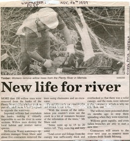
Newspaper - Newspaper Clipping, Whittlesea Post, New life for river, 24 Nov 1999
Workers remove more than 100 willow trees from the banks of the Plenty River in Mernda.Newsprint with black and white image.mernda, plenty river mernda, willow tree -
 Wodonga & District Historical Society Inc
Album - Ringer's River by Des Martin - Plate 30 - Cattle cross the river to New South Wales
When morning comes all the cattle have struggled back to N.S.W. and the Victorian police find their trap is empty. O'Day, though he has lost his horse, makes it to the far bank some 400 yards downstream. Of Erin and Keiran there is no sign.The album and images are significant because they document literature written by a prominent member of the Wodonga community. The presentation of this precis was supported by several significant district families and individuals.Ringer's River Album Coloured photo Plate 30des martin, many a mile, ringer's river, northeast victoria stories -
 Stawell Historical Society Inc
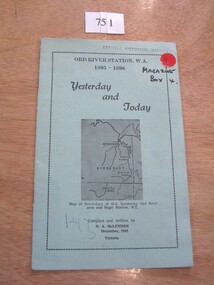
Book, N.A. McLennan, Yesterday and Today - Ord River Station WA 1895 - 1896 by N A McLennan, 1965
John McLennan's Period as Manager of the Ord River Station. W.A. adjoining Negri Station N.T., was 1895-6. The whole area consisted of 3,365,000 areas under a number of leasesand the then owner was Mr W.H. Osmand, who lived at "The Sycamores" four miles east of Stawell in Victoria. The Distance to Ord W.A. is 4,000 Miles.LIght green card cover with border, inside print and picture of a map Ord River Station W.A. 1895-1896 Yesterday and Today Map of North-East of W.A. Kimberly Ord River area Negri Station N.T. Complied and written by N.A. McLennan December 1965 1965 Victoriastawell, mclennan family -
 Kew Historical Society Inc
Photograph, Marnie McLeod, Floods of the River Yarra at Kew, 1916
The donation was accompanied by the following letter from the donor: "Hi. I found these in with family photos. Taken by family as Mamie McLeod was living in Fellows Street, Kew, so would be near there. Retain (or discard) as you see fit." [Donor's name and address withheld from public view]. To gain an insight into the flood levels at Kew, it is worth reading newspaper accounts of the event. The Age published an article - Valuable Gardens Destroyed at Kew - on 25 September 1916: "VALUABLE GARDENS DESTROYED AT KEW. From the heights of Studley Park, Kew, a splendid view of the flood waters can be obtained, and yesterday afternoon, despite continuous rain, crowds of citizens assembled there to witness the spectacle. There is a vast stretch of water some 300 or 400 yards broad, above the foot bridge connecting Gipps-street, Collingwood, and Studley Park. The river is only about 3 feet from the top of the embankment connecting with the ramp of the bridge on the Studiey Park side. When the upper llood waters come down it is almost a certainty that tne embankment will be submerged and the bridge rendered impassible. Below the bridge the waters again stretch out, and have submerged all the low-lying land on the Collingwood side and invaded the back premises ot the Kodak Co., Phoenix Biscuit Factory, a tannery adjoining thereto, the Shamrock Brewery, and Chinese gardens in the vicinity. At Walmer-street-bridge, at the end of Studley Park, the low-lying land on the Kew side is covered with water to the depth of many feet. Tlie land in question is owned in a great part by Mr Frank Lavers who haa gone in for intense culture on a pretty liberal scale on both the slopes of the hill and on the river flat. On the latter he is cultivating many acres of asparagus, and has at a considerable cost spent three years in preparing the ground and installing an irrigation system, reticulated from the Yan Yean water supply. This year the asparagus was put down, and the plants were in a promising condition. Tlie flood waters are now flowing fast over the land. The crop is ruined, and three years' work and expenditure destroyed. Mr. Laver's private residence fortunately is high above flood level, but two houses he owns off Young-street have been flooded out. Having been warned in time, the tenants removed their furniture hefore the water came down to Mr. Laver's residence, where they themselves have been given accommodation in the meantime. All the river flats in East Kew are under water. One or two low-lying houses have been flooded. Chipperfield's boat shed at Willsmere is nearly covered, and some Chinese gardens in the vicinity are several feet under water."This, and the other three photographs donated of floods in Kew are believed to be the earliest in the collection. Together with our original MMBW River Yarra map showing flood levels, these items, when compared allow researchers to gain a visual perspective of the extent of the flood in 1916. Black and white photograph of flooded trees in Kew with rising dry ground in distance.Inscription on reverse in pencil: "Flood River Yarra Kew Vic"river yarra, kew, floods 1916 -
 Greensborough Historical Society
Booklet, Yarra Plenty Regional Library, Learning strategic framework 2015-2020, 2016_
Yarra Plenty Regional Library has identified Learning as one of the core activities of the library service. This Learning Strategic Framework follows on from the YPRL Strategic Plan 2013-17. Goals and priorities are laid out in this booklet.34p., colour illus.yarra plenty regional library, yprl, learning activities, education -
![The Boulders on the Erskine River / [by] Nicholas Caire, circa 1876](/media/collectors/550653872162f11fb04854aa/items/5783420cd0cdd1176c6a3ffd/item-media/57834272d0cdd1176c6ac3f1/item-fit-380x285.jpg) Kew Historical Society Inc
Kew Historical Society IncPhotograph, Anglo-Australasian Photographic Company, The Boulders on the Erskine River, c. 1876
Nicholas Caire was born on Guernsey in the Channel Islands in 1837. He arrived in Adelaide with his parents in about 1860. In 1867, following photographic journeys in Gippsland, he opened a studio in Adelaide. From 1870 to 1876 he lived and worked in Talbot in Central Victoria. In 1876 he purchased T. F. Chuck's studios in the Royal Arcade Melbourne. In 1885, following the introduction of dry plate photography, he began a series of landscape series, which were commercially successful. As a photographer, he travelled extensively through Victoria, photographing places few of his contemporaries had previously seen. He died in 1918. Reference: Jack Cato, 'Caire, Nicholas John (1837–1918)', Australian Dictionary of Biography.An original, rare photograph from the series 'Views of Victoria: General Series' by the photographer, Nicholas Caire (1837-1918). The 60 photographs that comprise the series were issued c. 1876 and reinforced a neo-Romantic view of the Australian landscape to which a growing nationalist movement would respond. Nicholas Caire was active as a photographer in Australia from 1858 until his death in 1918. His vision of the Australian bush and pioneer life had a counterpart in the works of Henry Lawson and other nationalist poets, authors and painters.‘The boulders on the Erskine River’ : Views of Victoria (General Series) No.58 : Albumen silver photograph | Photo on card with Title and Description on reverse | Mounted 24 x 30 cm; Photo 12 x 17 cm.On Reverse: ‘For a distance of several miles this river runs its course over a granite bed, and is interrupted frequently by immense Boulders, which causes the stream to be broken up into rivulets, pools, rapids, falls, cataracts, &c. Many of these massive blocks of granite weigh from 40 to 50 tons. In the mid-distance of the present illustration, several of these great blocks can be seen obstructing the river in its course.’nicholas caire (1837-1918), erskine river, lorne (vic), landscape photography - victoria -
 Lakes Entrance Regional Historical Society (operating as Lakes Entrance History Centre & Museum)
Postcard, W S Vogt Bairnsdale, 1925 c
Note with photograph says This is a view of the Tambo River about a mile and a half up from where I am staying. The river here is narrow owing to cliffs with love from Arthur. Maybe Archie MacArthers boat GowrieSepia toned postcard of a passenger launch on the Tambo River below the cliffs upstream from Swan Reach Victoriaboats and boating, waterways, tourism -
 Wodonga & District Historical Society Inc
Album - Ringer's River by Des Martin - Plate 1 - Sean O'Day, Horse Breaker at "Gooloora" discusses his future
On a summer's day in 1891 Sean O'Day, Horse Breaker on James MacLough's "Gooloora" Station, is driving the Scots pastoralist in to the railhead at Overton after his annual inspection of that property. Silent and mature for his age, Sean was born in a dray while it was crossing the river during a flood, and has remained at home in it. Because he is always moving by dawn he is known in the borderland as Daylight O'Day. When MacLough asks him what he will be doing on the morrow O'Day replies that he will be manager. Questioned, he suggests that MacLough realises the background to his joke in that the station hands will, that night, celebrate the passing of the Boss's inspection. As they will have hangovers tomorrow all the work will naturally fall to himself, a teetotaller. MacLough nods assent, but, instead of leaving on the train, books a room for the night and a livery gig for the morrow, and drives himself to Gooloora early next morning. D.J. Martin as O'Day, H.S. Diffey as MacLough.The album and images are significant because they document literature written by a prominent member of the Wodonga community. The presentation of this precis was supported by several significant district families and individuals.Ringer's River Album Coloured photo Plate 1des martin, many a mile, ringer's river, northeast victoria stories -
Whitehorse Historical Society Inc.
Article, Plenty to recommend updating, 15/05/1999 12:00:00 AM
'Plenty to recommend updating' 1 Webb Court, Vermont, in Real Estate section of The Age, 15 May 1999.'Plenty to recommend updating' 1 Webb Court, Vermont, in Real Estate section of The Age, 15 May 1999. Renovation of 1930's house by Stephen Kosa.'Plenty to recommend updating' 1 Webb Court, Vermont, in Real Estate section of The Age, 15 May 1999.webb court, vermont, no1, kosa, stephen -
 Eltham District Historical Society Inc
Photograph, Doug Orford, Completion of bridge works across Yarra River at rear of Eltham Lower Park, July 2004
Bitumen shared pathway under construction at the new Eltham-Templestowe footbridge over the Yarra River off Homestead Road, Eltham which was completed in July 2004. The Yarra River Footbridge was opened in August 2004 and links the Diamond Creek Trail between the Shire of Nillumbik and City of Manningham. It is a shared pathway and also links with the Main Yarra Trail. It affords lovely views over the Yarra River.Three colour photographs showing commencement of construction of Eltham-Templestowe footbridge over Yarra River off Homestead Road, Eltham which was completed July 2004. Third photograph of dedictaion plaque at opening 30 Aug 2004bridges, yarra river, eltham south, eltham lower park, lenister farm, homestead road, asphaldt, bitumen, shared pathway, diamond creek trail -
 Lakes Entrance Regional Historical Society (operating as Lakes Entrance History Centre & Museum)
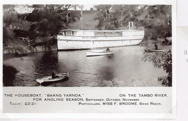
Postcard, 1930c
The houseboat Baang Yarnda on the Tambo River for angling season, September October November. Tariff 2 pound 2 shillings Particulars Miss F Broome Swan ReachSepia toned postcard of the houseboat Baang Yarnda associated with Broome's Federal Hotel houseboat is moored in the Tambo River, people fishing from two small rowing boats and motor boat on river. Tambo Upper Victoriaguesthouses, tourism, boats and boating -
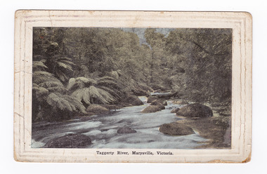 Marysville & District Historical Society
Postcard (item) - Colour tinted postcard, Renwick, Pride & Nuttall, Taggerty River, Marysville, Victoria, 1916
An early colour tinted photograph of the Taggerty River in Marysville in Victoria.An early colour tinted photograph of the Taggerty River in Marysville in Victoria.Australian Enamellers. Country Series No. 3. Produced in Australia To Ms Marlene./ To wish you/ well; & To assist in/ making you as comfy/ as possible. I hope you/ are keeping well & fit/ & that it wont be long/ before you are on your/ way back to Aust. I/ suppose you have heard/ that Jack is on his/ way home, we are/ looking forward to/ the day when he arrives./ My best wishes to you/ & kind regards/ Sincerely yr/ friend/ Raell Dennistaggerty river, marysville, victoria, postcard, souvenir -
 Greensborough Historical Society
Slide, Fred Harris, Main Street, old river bridge Greensborough, 1949c
Taken about 1949, this colour slide shows Main Street Greensborough crossing the Plenty River via the 'old' bridge.1 photographic slide in yellow Kodak packet.Name of donor and title of slide written on outside of packetmain street greensborough, plenty river, main street bridge -
 Greensborough Historical Society
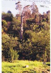
Photograph - Photograph (Copy), Anne Paul, Squizzy Taylor's target tree, taken from old road in front of Plenty Bridge Hotel, Lower Plenty 2003, 2003_05
Squizzy Taylor's target tree, taken from old road in front of Plenty Bridge Hotel, Lower Plenty 2003. It is believed that Squizzy Taylor hid at the Plenty Bridge Hotel and used this tree for target practice.2 colour photographs printed on paper, handwritten captionslower plenty, plenty river, squizzy taylor, plenty bridge hotel -
 Kew Historical Society Inc
Map, MMBW, River Yarra Beautification Schemes, c.1913
The Melbourne and Metropolitan Board of Works (MMBW) was established by an act of the Victorian Parliament in 1890 to prepare for and to implement a sewerage and water reticulation system across what was then inner Melbourne, its surrounding and middle distance suburbs, including Kew. The MMBW was disbanded in 1991.The map collection of the Kew Historical Society has at its core the historic maps assembled and originally stored in the City Engineer's Department of the City of Kew. These include maps in a number of scales. The vast majority of maps were produced by the MMBW in the first two decades of the twentieth century, and are solid working maps, backed by linen for durability. These maps are historically significant to Kew, the City of Boroondara and to the history of the development of state utilities in Victoria. A number of the Kew maps have additional details added by former municipal officers, including the levels reached by various floods. As these were working documents, information was added to them long after the period of their initial production and distribution.Map of the City of Kew showing part of the River Yarra Beautification Schemes. The map shows development to date and the flood levels reached in 1923 and 1924. This map may have been adapted from an earlier map, as most development in central Kew and Studley Park had occurred by this date yet numerous streets are not represented. Public buildings and institutions are clearly represented and named on the map as are significant public transport infrastructure (eg the Outer Circle railway).MELBOURNE AND METROPOLITAN BOARD OF WORKS / RIVER YARRA BEAUTIFICATION SCHEMES / SCHEME / SCALE 10 CHAINS TO AN INCHmelbourne & metropolitan board of works, mmbw maps, mmbw plans, city of kew, flood levels -- kew (vic.), cartography -
![Newspaper Clipping - Digital Image, End of Plenty Bridge 1968 [Bluestone Bridge Greensborough], 16/04/1968](/media/collectors/4f729f5697f83e03086015b8/items/5eb3aa9d21ea670b94feceb5/item-media/5eb3acc621ea670b9400fd28/item-fit-380x285.jpg) Greensborough Historical Society
Greensborough Historical SocietyNewspaper Clipping - Digital Image, End of Plenty Bridge 1968 [Bluestone Bridge Greensborough], 16/04/1968
Removal of the bluestone bridge over the Plenty River in 1968. Photograph shows workmen removing the steel girders which covered the centre span. Pioneer Reserve is also mentioned.News clipping, black and white text and image.plenty river greensborough, bluestone bridge greensborough, pioneer reserve greensborough -
 Eltham District Historical Society Inc
Negative - Photograph, J.A. McDonald, Eltham-Yarra Glen Road, Lower Plenty, c. July 1962
View looking west across the Eltham-Yarra Glen Road approaching the Lower Plenty Bridge near turn-off for the Golf Club Hotel. Present-day Lower Plenty Road follows a revised alignment across a new bridge. The former bridge is now part of the Plenty River Trail and Edward Willis Court now follows this section of the original Eltham-Yarra Glen Road.. The Golf Club Hotel is gone and a new Lower Plenty Hotel was built slightly further up the hill.Record of various Shire of Eltham infrastructure works undertaken during the period of 1952-1962 involving bridge and road reconstruction projects, sometimes with Eltham Shire Council Project Reference numbers quoted. It was during this period that a number of significant improvements were made to roads and new bridges constructed within the shire that remain in place as of present day (2022). In many situations, the photos provide a tangible visible record of infrastructure that existed throughout the early days of the Shire. The album was put together by or under the direction of the Shire Engineer, J.A. McDonald.1962-07, shire of eltham, old eltham road, edward willis court, eltham-yarra glen road, golf club hotel, infrastructure, lower plenty, road construction -
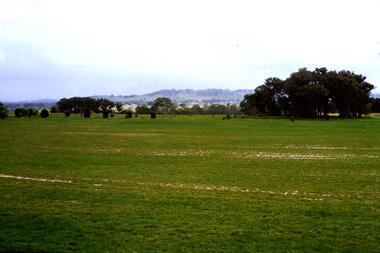 Greensborough Historical Society
Slide - Photograph, John Ramsdale, River flood plain looking west: Slide 67, 1990s
Photograph shows a rural scene with water over ground. This is the Plenty River flood plain looking west, Yan Yean or MerndaPart of the John Ramsdale collection of slides and audio visual material.Colour photograph scanned from slide.No maker's marks. No caption on slide.plenty river, yan yean, mernda