Showing 1812 items
matching rivers in victoria
-
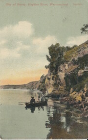
 Halls Gap & Grampians Historical Society
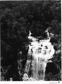
Photograph - B/W, C 1960s
A Forestry Commission photo of MacKenzie Falls.Photo shows a large waterfall (MacKenzie Falls), taken from a fairly high vantage point. The river comes into the falls in two separate streams and there is a large volume of water flowing. The falls are surrounded by thick bush."Publicity & Public Relations branch. When reproducing please Acknowledge FORESTS COMMISSION, VICTORIA. Negative No. 322-2" stamped on rear (except negative number, which is hand written in pen)scenery, mackenzie falls -
 Eltham District Historical Society Inc
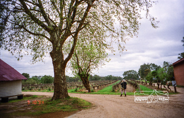
Photograph, Chateau Tahbilk Winery; 9 Oct 1994, 20/11/1994
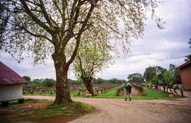
... Victoria. It crosses the Goulbum River near Chateau Tahbilk... Victoria. It crosses the Goulbum River near Chateau Tahbilk ...Brief visit of the Major Mitchell Trail. This car based trail follows the route of the famous explorer right across Victoria. It crosses the Goulbum River near Chateau Tahbilk and Mitchelton Wineries and passes through Nagambie.Record of the Society's history of activities - Spring 1994 excursionRoll of 35mm colour negative film, 4 stripsKodak Gold 100-4shire of eltham historical society, activities, chateau tahbilk winery, major mitchell trail -
 Eltham District Historical Society Inc
Photograph, Chateau Tahbilk Winery; 9 Oct 1994, 20/11/1994
... Victoria. It crosses the Goulbum River near Chateau Tahbilk... Victoria. It crosses the Goulbum River near Chateau Tahbilk ...Brief visit of the Major Mitchell Trail. This car based trail follows the route of the famous explorer right across Victoria. It crosses the Goulbum River near Chateau Tahbilk and Mitchelton Wineries and passes through Nagambie.Record of the Society's history of activities - Spring 1994 excursionRoll of 35mm colour negative film, 4 stripsKodak Gold 100-4shire of eltham historical society, activities, chateau tahbilk winery, major mitchell trail -
 Eltham District Historical Society Inc
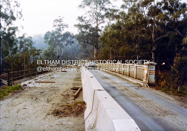
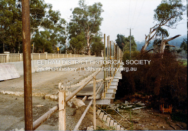
Photograph, Ruth H. Pendavingh, Widening of Main Road Bridge over the Diamond Creek, Eltham, 1984c
Three colour photographs of the construction work of the widening works of the bridge over the Diamond Creek, Eltham, near Lower Eltham Park Victoria. The bridge re-opened on October 25, 1984. (EDHS Chronology of known local events 1835- early 2000) eltham, main road, main road bridge, bridges, construction, diamond creek (river) -
 Eltham District Historical Society Inc
Photograph, Ruth H. Pendavingh, Widening of Main Road Bridge over the Diamond Creek, Eltham, 1984c
Three colour photographs of the construction work of the widening works of the bridge over the Diamond Creek, Eltham, near Lower Eltham Park Victoria. The bridge re-opened on October 25, 1984. (EDHS Chronology of known local events 1835- early 2000) eltham, main road, main road bridge, bridges, construction, diamond creek (river) -
 Kiewa Valley Historical Society
Postcard Circa 1950, Lake Guy Dam and Bogong Village, Circa 1950
This postcard was produced in the 1950's for the tourist trade in the Kiewa Valley and Alpine region. It encompasses the period when the State of Victoria was pressured by the ever increasing demand by industry and its population for electricity supplies. Hydro electricity was seen as an untapped natural resource to quench this demand. The Victorian Alps and the rivers flowing into its valleys was ideal for the construction of the Kiewa Hydro Electricity Scheme. The late 1940's saw the development of this scheme and the changing of sections of alpine landscape is covered by this and other postcards/pictures (tourists, construction workers, and established rural populations). This period in time was before the established wildlife and forest/nature groups became political activist who changed legislative acts to protect the environment.This rural region (Kiewa Valley/alpine plains) was at most only significant to a smaller group of winter sports, summer hikers/horse riders and rural farmers/graziers. The numbers of tourists and the increase in the local resident population was boosted by the construction of the Hydro Electricity Scheme. This influx to the regional population resulted in a corresponding diversity in services and brought about an environment that responded to a growing level of tourists and thereby permitting this industry to grow more rapidly than it would have naturally. This postcard details an attraction to the "cleaner" method of providing electricity. This postcard was purchased in 1950 by a surveyor at Landford's Gap.This black and white photograph from a Valentine's postcard is from a V2 Argus photograph postcard. It is on a 200g/m paper density photo side gloss. See 0480 (B) - (F) for other photos of similar postcards.In white lettering " LAKE GUY & BOGONG VILLAGE KIEWA HYDRO-ELECTRIC PROJECT"kiewa valley tourism, victorian alps, alternate energy supplies, alpine population growth -
 Kiewa Valley Historical Society
Postcard Circa 1950, Snowfall at Bogong Village Kiewa Hydro-Electric Project, 1950s
This postcard was produced in the 1950's for the tourist trade in the Kiewa Valley and Alpine region. It encompasses the period when the State of Victoria was pressured by the ever increasing demand by industry and its population for electricity supplies. Hydro electricity was seen as an untapped natural resource to quench this demand. The Victorian Alps and the rivers flowing into its valleys was ideal for the construction of the Kiewa Hydro Electricity Scheme. The late 1940's saw the development of this scheme and the changing of sections of alpine landscape is covered by this and other postcards/pictures (tourists, construction workers, and established rural populations). This period in time was before the established wildlife and forest/nature groups became political activist who changed legislative acts to protect the environment.This rural region (Kiewa Valley/alpine plains) was at most only significant to a smaller group of winter sports, summer hikers/horse riders and rural farmers/graziers. The numbers of tourists and the increase in the local resident population was boosted by the construction of the Hydro Electricity Scheme. This influx to the regional population resulted in a corresponding diversity in services and brought about an environment that responded to a growing level of tourists and thereby permitting this industry to grow more rapidly than it would have naturally. This postcard details an attraction to the "cleaner" method of providing electricity. This postcard was purchased in 1950 by a surveyor at Landford's Gap.This scanned black and white photograph of a postcard, shows vehicles covered in thick snow at Bogong Village in 1950. See 0480(A), (C) - (F) for other similar photos of postcards available at this period."SNOWFALL AT BOGONG VILLAGE KIEWA HYDRO-ELECTRICITY PROJECT"kiewa valley tourism, victorian alps, alternate energy supplies, alpine population growth, bogong village, secv -
 Kiewa Valley Historical Society
Postcard Circa 1950, Scene in Bogong Village Kiewa Hydro-Electric Project, 1950s
This postcard was produced in the 1950's for the tourist trade in the Kiewa Valley and Alpine region. It encompasses the period when the State of Victoria was pressured by the ever increasing demand by industry and its population for electricity supplies. Hydro electricity was seen as an untapped natural resource to quench this demand. The Victorian Alps and the rivers flowing into its valleys was ideal for the construction of the Kiewa Hydro Electricity Scheme. The late 1940's saw the development of this scheme and the changing of sections of alpine landscape is covered by this and other postcards/pictures (tourists, construction workers, and established rural populations). This period in time was before the established wildlife and forest/nature groups became political activist who changed legislative acts to protect the environment. This rural region (Kiewa Valley/alpine plains) was at most only significant to a smaller group of winter sports, summer hikers/horse riders and rural farmers/graziers. The numbers of tourists and the increase in the local resident population was boosted by the construction of the Hydro Electricity Scheme. This influx to the regional population resulted in a corresponding diversity in services and brought about an environment that responded to a growing level of tourists and thereby permitting this industry to grow more rapidly than it would have naturally. This postcard details an attraction to the "cleaner" method of providing electricity. This postcard was purchased in 1950 by a surveyor at Landford's Gap. The couple shown in this photograph would have been employed by the S.E.C. under the Kiewa Hydro-Electricity Scheme.This item is a scanned black and white photograph of a couple walking along a gravel street in Bogong Village in 1950. See 0480 (A) ,(B), (D) - (F) for other photos of similar postcards" SCENE IN BOGONG VILLAGE KIEWA HYDRO-ELECTRIC PROJECT"kiewa valley tourism, victorian alps, alternate energy supplies, alpine population growth, bogong, secv -
 Kiewa Valley Historical Society
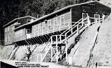
Postcard Circa 1950, Men's Mess No.4 Power Station, Kiewa Hydro-Electric Project
This postcard was produced in the 1950's for the tourist trade in the Kiewa Valley and Alpine region. It encompasses the period when the State of Victoria was pressured by the ever increasing demand by industry and its population for electricity supplies. Hydro electricity was seen as an untapped natural resource to quench this demand. The Victorian Alps and the rivers flowing into its valleys was ideal for the construction of the Kiewa Hydro Electricity Scheme. The late 1940's saw the development of this scheme and the changing of sections of alpine landscape is covered by this and other postcards/pictures (tourists, construction workers, and established rural populations). This period in time was before the established wildlife and forest/nature groups became political activist who changed legislative acts to protect the environment.Although this photo details the eating facilities of the construction workers at the power station it was not only a postcard for the people employed in the Hydro Scheme is was also provided to tourists visiting the area and thus used for promotional purposes.This rural region (Kiewa Valley/alpine plains) was at most only significant to a smaller group of winter sports, summer hikers/horse riders and rural farmers/graziers. The numbers of tourists and the increase in the local resident population was boosted by the construction of the Hydro Electricity Scheme. This influx to the regional population resulted in a corresponding diversity in services and brought about an environment that responded to a growing level of tourists and thereby permitting this industry to grow more rapidly than it would have naturally. This postcard details an attraction to the "cleaner" method of providing electricity. This postcard was purchased in 1950 by a surveyor at Landford's Gap. The men shown in this photograph would have been employed by the S.E.C. under the Kiewa Hydro-Electricity Scheme.This item is a scanned black and white photograph of a construction worker walking from stairs leading down from the men's mess building, in 1950. See 0480 (A) -(C), (E) - (F) for other photos of similar postcards"MEN'S MESS No.4 POWER STATION AREA, KIEWA HYDRO-ELECTRIC PROJECT" "ARGUS PHOTO V.IIkiewa valley tourism, victorian alps, alternate energy supplies, alpine population growth, secv -
 Kiewa Valley Historical Society
Postcard Circa 1950, Mt. Beauty Village, Kiewa Hydro-Electricity Project, circa 1950
This postcard was produced in the 1950's for the tourist trade in the Kiewa Valley and Alpine region. It encompasses the period when the State of Victoria was pressured by the ever increasing demand by industry and its population for electricity supplies. Hydro electricity was seen as an untapped natural resource to quench this demand. The Victorian Alps and the rivers flowing into its valleys was ideal for the construction of the Kiewa Hydro Electricity Scheme. The late 1940's saw the development of this scheme and the changing of sections of alpine landscape is covered by this and other postcards/pictures (tourists, construction workers, and established rural populations). This period in time was before the established wildlife and forest/nature groups became political activist who changed legislative acts to protect the environment. The regulatory pondage on the northern aspect of the village had no water over-spill from the unfinished power station.This rural region in 1950 (Kiewa Valley/alpine plains) was at most only significant to a smaller group of winter sports, summer hikers/horse riders and rural farmers/graziers. The numbers of tourists and the increase in the local resident population was boosted by the construction of the Hydro Electricity Scheme. This influx to the regional population resulted in a corresponding diversity in services and brought about an environment that responded to a growing level of tourists and thereby permitting this industry to grow more rapidly than it would have naturally. This postcard details an attraction to the "cleaner" method of providing electricity. This postcard was purchased in 1950 by a surveyor at Landford's Gap. The couple shown in this photograph would have been employed by the S.E.C. under the Kiewa Hydro-Electricity Scheme.This item is a scanned black and white photograph of a panoramic view of Mount Beauty Village in 1950 (a closed village, entry by pass only). The regulatory pondage has earthen walls but no water.See 0480 (A) -(D) and (F) for other photos of similar postcards"MT. BEAUTY VILLAGE KIEWA HYDRO-ELECTRIC PROJECT"kiewa valley tourism, victorian alps, alternate energy supplies, alpine population growth -
 Kiewa Valley Historical Society
Postcard Circa 1950, Howman Gap Hostel under snow Kiewa Hydro-Electric Project, Circa 1950
This postcard was produced in the 1950's for the tourist trade in the Kiewa Valley and Alpine region. It encompasses the period when the State of Victoria was pressured by the ever increasing demand by industry and its population for electricity supplies. Hydro electricity was seen as an untapped natural resource to quench this demand. The Victorian Alps and the rivers flowing into its valleys was ideal for the construction of the Kiewa Hydro Electricity Scheme. The late 1940's saw the development of this scheme and the changing of sections of alpine landscape is covered by this and other postcards/pictures (tourists, construction workers, and established rural populations). This period in time was before the established wildlife and forest/nature groups became political activist who changed legislative acts to protect the environment.This rural region (Kiewa Valley/alpine plains) was at most only significant to a smaller group of winter sports, summer hikers/horse riders and rural farmers/graziers. The numbers of tourists and the increase in the local resident population was boosted by the construction of the Hydro Electricity Scheme. This influx to the regional population resulted in a corresponding diversity in services and brought about an environment that responded to a growing level of tourists and thereby permitting this industry to grow more rapidly than it would have naturally. This postcard details an attraction to the "cleaner" method of providing electricity. This postcard was purchased in 1950 by a surveyor at Landford's Gap.This item is a scanned black and white photograph of a panoramic view of Howman Gap Hostel under snow in 1950 (a closed village, entry by pass only). This accommodation was for construction workers only. See 0480 (A) -(E) for other photos of similar postcards.On the photo, " Howman Gap Hostel under snow Kiewa Hydro-Electric Project" . On postcard address and personal information side "V.2 Valentine's Post Card "kiewa valley tourism, victorian alps, alternate energy supplies, alpine population growth, bogong, secv, howman's gap hostel -
 Kiewa Valley Historical Society
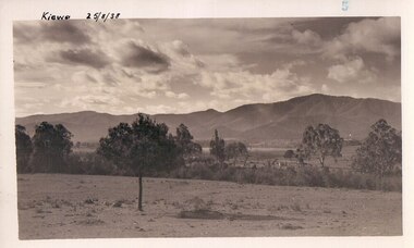
Black and white photograph of Surveyor's Camp, 1938, Kiewa River and surveyor's Camp 25/8/38, 25/08/1938
Surveying under the prevailing conditions at this time was an arduous and demanding task. There were no roads beyond Tawonga and access was by bridle tracks, on foot or horseback. This camp was to provide accommodation to those men who were surveying the road from South Tawonga to the Bogong High Plains which was commenced in April, 1938. The actual work was undertaken by the Country Roads Board, on behalf of the State Electricity Commission, using three Caterpillar diesel crawler tractors equipped with Kay Bruneriei (Brunner) lhydraulically operated trailbuilders (angle dozers)This photograph shows the primitive living conditions that were endured by those carrying out the initial field investigations and surveys for the Kiewa Hydro Electric Scheme. It is possibly one of the few photographs in existence of this camp and of the very rustic timber foot bridge across the West Kiewa river. It has been taken from approx. 100m up Simmonds Creek Road. A black and white photograph showing a small, timber foot bridge across the West Kiewa River. There is a man standing on the bridge and two small huts on the far side of the river, against a backdrop of Mt. Beauty and Mt. Bogong.At the top of the photograph, handwritten in black ink is the inscription "Kiewa River and Surveyor's Camp 25/8/38". The number 4 is stamped towards the right upper corner. On the back, in a circle, about 1.3cm in diameter, are the words "Kodak Print". The word "Velox" is faintly discernible on the back as well.surveyor, tawonga, west kiewa river, bridge, camp, secv -
 Kiewa Valley Historical Society
Black and white photograph of farmland, Kiewa, 25/8/38, circa 1938
This photograph was taken in August, 1938 some eight years prior to the establishment of Mt. Beauty as a township. The area was still being used for grazing, and the land was eventually acquired from the local land owners by the State Electricity Commission. The construction of the road, from Tawonga to the High Plains, was commenced in April of this year. This allowed men and heavy equipment to be transported to the work sites for the construction of the Kiewa Hydro Electric Scheme This photograph is important as it shows the upper Kiewa Valley as it was before the establishment of the town of Mt. Beauty. The land has been cleared of natural growth and has been used for grazing cattle. By 1946 housing construction had commenced for the new town of Mt. Beauty and by 1948 street construction in the southern part of the town was completed as far as Hill Street.A black and white photograph of farmland with Mt. Emu in the background. This has been taken from where Mt. Beauty township now stands prior to road making and the erection of houses. A line of trees below the hill line indicates the position of the East Kiewa River. (No. 5 in a set of 8) Handwritten in black ink on the upper left corner of the photograph is the inscription 'Kiewa 25/8/38' and the number 5 has been stamped on the upper right hand corner. On the back is the word 'Velox' which is the name of the photographic paper on which the photo was developed.road construction, kiewa, tawonga, mt. beauty, secv -
 Eltham District Historical Society Inc
Photograph, Chateau Tahbilk Winery; 9 Oct 1994, 20/11/1994
... Victoria. It crosses the Goulbum River near Chateau Tahbilk... Victoria. It crosses the Goulbum River near Chateau Tahbilk ...Brief visit of the Major Mitchell Trail. This car based trail follows the route of the famous explorer right across Victoria. It crosses the Goulbum River near Chateau Tahbilk and Mitchelton Wineries and passes through Nagambie.Record of the Society's history of activities - Spring 1994 excursionRoll of 35mm colour negative film, 4 stripsKodak Gold 100-4shire of eltham historical society, activities, chateau tahbilk winery, major mitchell trail -
 Eltham District Historical Society Inc
Photograph, Liz Pidgeon, Heritage Excursion; Eltham Lower Park Walk and Talk, 1 July 2017, 1 July 2017
Information board: Hohnes Hill Flora & Fauna Reserve produced by Shire of Nillumbik and Parks Victoria which includes text and images with references to the Eltham Copper Butterfly. Newsletter No., 234, June 2017 Heritage Excursion - Saturday 1st July - Eltham Lower Park - Walk and Talk Eltham Lower Park has played an important part in the history of our area since the early days of European settlement when it was used by local residents as an informal racecourse. Prior to that its location at the junction of the Diamond Creek and the Yarra River made it an important meeting place for the Wurundjeri people. The park combines formal elements and sporting facilities with remnant bushland that is of environmental significance. It is home to sporting and horse riding clubs, popular play spaces and the Diamond Valley Miniature Railway, which attracts large numbers of visitors. The park will be the venue for our July excursion which will comprise a walk of about 3.5 km around the park and adjacent areas. Along the way we will discuss the history and natural history of the area. The path along the creek and the river provides a pleasant and scenic walk. This walk on Saturday 1st July is about 3.5 km in length and will take 2 to 2.5 hours. It will start at 2pm at the Main Road car park at the front of the park. (Melway ref 21 H 10). Born Digitalheritage excursion, activities, eltham district historical society, eltham lower park, hohnes hill, reserve, eltham copper butterfly, sign -
 Eltham District Historical Society Inc
Photograph, Peter Pidgeon, Killeavey, Laughing Waters Road, Eltham 5 Nov 2016, 5 Nov 2016
The beautiful Yarra river lies before us; the scar or 'toe hold' tree lies in front of Cam to the right Heriitage Excursion - Kileavey Walk and TalkBorn Digitalactivities, eltham district historical society, heritage excursion, kileavey, parks victoria, laughing waters road, eltham, wurundjeri -
 Kiewa Valley Historical Society
Photos - Kiewa Hydro Electric Scheme - Dartmouth, Official S.E.C.V. photos
Dartmouth Dam was built on the Mitta Mitta River in the 1970s. It is the highest dam in Australia (2022). It is the largest storage in Victoria (2022). It was built primarly for irrigation and urban use. The power station has the largest hydro-electric generator in Victoria (2022). -
 Kiewa Valley Historical Society
Tapes - x10 Native Orchids and Birds, Lake Guy
Orchids, birds on the Bogong High Plains and surrounds and the SECV construction on the Kiewa Hydro Electric Scheme were topics of interest for the workers living there. Taping them would have been an interesting hobby for Jack Farrell.Jack Farrell (1920s - 1990s) worked for the State Electricity Commission of Victoria on the KHES. He worked in the workshop and lived on the river side of Simmonds Creek Road. x10 tapes of orchids, birds and Lake Guy etc. and 1 Panasonic Battery Pack VW-VBC4E for movie camera.The battery has a sticker on it "$99.00"orchids, birds, kiewa hydro electric scheme, movies of native flora, movies of birds -
 Kiewa Valley Historical Society
Souvenirs - Mt Beauty
Originally an SEC town built for workers on the Kiewa Hydro Electric Scheme. It became a tourist centre from the 1960s.Examples made to increase tourism with historical photos, historical items no longer used or sought after. Items such as these are a different way of advertising to on-line methods used today1. Coloured shiny poster with photos of mountains, river and fishing backed on to orange & white pattern. 2. Christmas card "Mt Bogong and Mr Beauty Township" on the back in gold Markdon Prints, Porpunkah ..."" 3. Plastic coloured trays x3 - Mt Beauty Vic. x2 and Mt Beauty Victoria (4 photos including Mt Bogong, Falls Creek x2, Kiewa Valley.) 4.Silver plated spoon "Mt Beauty Vic." 1. Printed bottom left hand corner "Mount Beauty, Victoria" 2.Centre front "The Seasons Greetings" with title written under painting also "From the painting by Marcus L. O'Donnell" 3. On the back of the tray with 4 photos - embossed "A Starlite Product ..." 4. Embossed on back of handle "Stuart / Silver plated"mt beauty tourism -
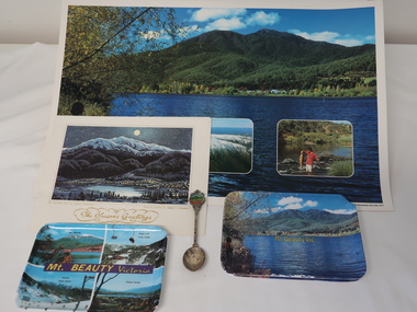
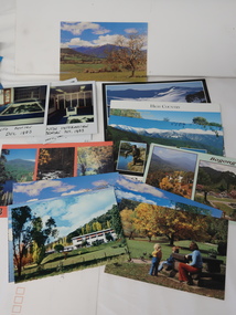 Kiewa Valley Historical Society
Photos, Postcards - Kiewa Valley
Mt Beauty township, at the head of the Kiewa Valley, is situated at the foot of Mt Bogong. The town was established by the State Electricity Commission of Victoria during the construction of the Kiewa Hydro Electric Scheme on the High Plains.Mt Beauty is a popular tourist resort. The main highway from Mt Beauty to the Bogong High Plains is most picturesque throughout the year. During the winter months, Falls Creek provides access to Falls Creek Ski Village for snow sports. Tawonga, 6.5 km north of Mt Beauty, is famed for its trout fishing and camping on the Kiewa River. Deciduous trees make a show of colour during Autumn. The postcards are of historical value showing photos taken at an earlier time.The postcards can be compared to the attractions of the time as they do not include cycling (mountain bikes and road bikes), snow boarding, gliding and paragliding. Advertising for tourism has also changed as attractions are now available on-line. 1. 9 Coloured Photos of Bogong (5) and Visitors Information Centre display (4) 2. Two fold out coloured sets of postcards "Mt Beauty and the Kiewa Scheme", "Mt. Beauty Victoria" 3. x10 Coloured postcards Mt Beauty, Kiewa Valley, Bogong 4. x6 Coloured postcards High Country and Bogong Villagepostcards kiewa valley -
 Kiewa Valley Historical Society
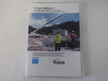
DVD - AGL Bogong Power Development & 6 DVDs with students contributions, In Our Backyard
Students from Mt Beauty Secondary College produced this set of 3 DVDs re the development of AGL's Bogong Power Development 2007-2009. This was an addition to the Kiewa Hydro Electric Scheme built by the SECV in the 1950s. The information covers many aspects of the Development which is of interest as well as being educational for the students. The request re the SECV Adit Shaft was to assist with the information board beside the shaft on the Gorges Walk on the West Kiewa River. DVDs were a digital means of passing on information to an audience and enabled multiple copies to be made. The Kiewa Hydro Electric Scheme is in the Kiewa Valley producing clean energy for Victoria. The Bogong Power Development increased the production of electricity in line with more clean energy and gave locals employment and students an insight into its construction and issues. The technical aspect of using DVDs to present this knowledge was also part of the education for the local students. x3 DVDs with hard clear plastic box cover. The cover has a photo on the front with the title typed above it and production details below along with the AGL logo and its Mt Beauty logo.On the back the details (title and content) for each of the 3 DVDs is given. DVD Stories: 1, 2, 4, 7 & 8 and DVD "AGL Photos West Kiewa - In response to letter re photos of Adit Shaft. July 2013"bogong power development project, mt beauty secondary college 2007-2009, agl -
 Kiewa Valley Historical Society
VHS Tape - Kiewa Hydro Electricity Scheme x2, Kiewa, Circa 1990
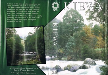
This VHS was produced by the State Electricity Commission of Victoria, to show the pristine state of the Kiewa River and Valley post the completion of the Kiewa Hydro Electricity Scheme (Circa 1950s), The late 1970s on wards was the beginning of deeper social scrutineering by pro environmental groups such as the Australian Wilderness Society (1976) and the Greens (political Party), before, during and after the construction phases of any man made structures in forest/bush areas which may or could damage or adversely affect the natural flora and fauna of sites. This promotional VHS, which was produced in the 1990s, was to project that unlike the Tasmanian State Electricity Commission (Franklin Dam issue), the Victorian State Electricity Commission acted in a way to protect the environment to the maximum level possible. With the passage of time since, and the issue of the global push to minimise carbon pollution, and as an alternative to coal fired power stations, the use of hydro electricity can now be seen as a highly efficient alternative to "coal powered" electricity. This VHS is a snap shot in time (1990) when the Kiewa Valley was still relatively under populated and holiday houses owned by city bound workers was still relatively insignificant. As more and more holiday makers retire to a small but friendly region(Kiewa Valley and Mount Beauty) the increase in visitor numbers will affect the local rural bush scene more and more. The changes that will occur (in time) can be measured against the scenes presented in this video. The additional resources provided by the State Electricity Commission of Victoria of "alpine bush" fire control and management, together with an ongoing educational scheme for school children in learning about what constitutes the Alpine country's unique environment, are a very important offshoot, benefitting to both the communities within the Kiewa Valley and regional Victoria.This VHS tape is stored within its own plastic cover which has a front side covered by a coloured photograph(both front and back cover) of the Kiewa River, just to the north east of the Mount Beauty township. The VHS tape is nestled within a formed inner structure which not only prevents the tape from moving to and fro but also unnecessary intrusion of foreign particles.Front cover "KIEWA" on the spine top circle with lines projecting out and below this "SEC". Middle of spine "KIEWA" and bottom of spine "VHS"secv, kiewa valley, dale-bromley, cy-duff, chris- harding, michael-glucz, forestation education, wilderness photography, nature film. -
 Kiewa Valley Historical Society
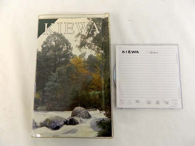
DVD - Kiewa Hydro Electricity Scheme, KIEWA, Circa 1990
This DVD is a digital reproduction of a VHS produced by the State Electricity Commission of Victoria, to show the pristine state of the Kiewa River and Valley post the completion of the Kiewa Hydro Electricity Scheme (Circa 1950s), The late 1970s on wards was the beginning of deeper social scrutineering by pro environmental groups such as the Australian Wilderness Society (1976) and the Greens (political Party), before, during and after the construction phases of any man made structures in forest/bush areas which may or could damage or adversely affect the natural flora and fauna of sites. This promotional VHS, which was produced in the 1990s, was to project that unlike the Tasmanian State Electricity Commission (Franklin Dam issue), the Victorian State Electricity Commission acted in a way to protect the environment to the maximum level possible. With the passage of time since, and the issue of the global push to minimise carbon pollution, and as an alternative to coal fired power stations, the use of hydro electricity can now be seen as a highly efficient alternative to "coal powered" electricity. This item provids a snap shot in time (1990) when the Kiewa Valley was still relatively under populated and holiday houses owned by city bound workers was still relatively insignificant. As more and more holiday makers retire to a small but friendly region(Kiewa Valley and Mount Beauty) the increase in visitor numbers will affect the local rural bush scene more and more. The changes that will occur (in time) can be measured against the scenes presented in this video. The additional resources provided by the State Electricity Commission of Victoria to "alpine bush" fire control and management, together with an ongoing educational scheme for school children in learning about what constitutes the Alpine country's unique environment, are a very important offshoot, benefitting to both the communities within the Kiewa Valley and regional Victoria. The DVD is nestled within a formed inner structure (case), which not only prevents the disc from moving to and fro but also unnecessary intrusion of foreign particles.This DVD is a TDK data/video recordable single sided 4.7 GB disc.It is a 1-16x speed."KIEWA" on disc.secv, kiewa valley, dale-bromley, cy-duff, chris- harding, michael-glucz, forestation education, wilderness photography, nature film. -
 Eltham District Historical Society Inc
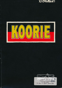
Book, Koorie Heritage Trust, Koorie, 1991c
Oldest culture - Yarra River and Port Phillip - Religion - Serpents - Fire - In 1830 - First contacts - Massacre map - Survival - Identity - Resistance and rights (Pastor Sir Douglas Nicholls) - Land rights - From hand-out to hand-back - Aborigines in war - Sportspeople - Cultural heritage.Paperback; 57, [3] pages : illustrations, maps, ports ; 30 cm.ISBN 0724198105aborigines, social customs, koorie, victoria -
 Eltham District Historical Society Inc
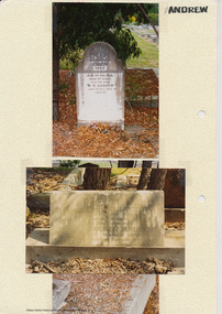
Folder, Andrew
James Andrew Kangaroo Ground, 1870 "James Andrew, Whittlesea, born in East Palford, Devonshire, England, in 1827, arrived in Adelaide in February 1850 per ship Lady McCaughton and almost immediately sailed in a coasting vessel to Melbourne, where the first work he undertook was clearing earth from a stone quarry in Collingwood. He next carried stones for masons engaged in building the Bishop’s Palace, and then was employed in Cambellfield mowing hay. He was at Saltwater River on Black Thursday, and afterwards took a little farm at Darebin Creek, remaining there for four years. He went up to Kangaroo Ground in 1859 and lived there until he bought his present property at Whittlesea, a farm of between 300 and 400 acres. He has been twice married, and had a family of six children." "Andrew, W. B. Eltham, is a native of England, born in 1822. Coming out to Australia in 1842, he lived in Brighton, Victoria for fifteen years, when he re-visited England for a year. Returning to Victoria fourteen or fifteen years ago, he commenced storekeeping at Eltham, where he has carried on that business ever since. Mr Andrew has always taken a lively interest in the public affairs of town and district” from "Victoria and its Metropolis: Past and Present" written in 1888 by Alexander Sutherland. Chapter 19, "The Upper Yarra District" pages [402] - 415. Includes descriptions of some townships and short biographies of local residents. Page 405 Folder of information on James Andrew, Trustee Kangaroo Ground Cemetery, Kangaroo Ground 1870 William Bravery Andrew, Eltham, 1870s-1880s Ernest James Andrew, Eltham, Eltham Shire Councillor, 1920s-1950 and Ellen Matilda Brown Andrewjames andrew, pioneer, kangaroo ground, ernest james andrew, william bravery andrew, ellen andrew, eltham cemetery, biography, ellen harper andrew (nee clarke), ellen matilda andrew (nee brown), eltham war memorial gate, eltham war memorial trust -
 Eltham District Historical Society Inc
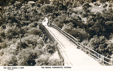
Photograph, The Bridge, Warrandyte, Victoria
Postcard showing old timber bridge over Yarra River at WarrandyteThe Rose Series P.2046bridges, yarra river, warrandyte, kangaroo ground road, postcards -
 Eltham District Historical Society Inc
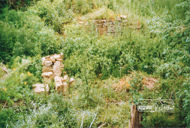
Photograph, Ruins of Coulstocks Mill, Janefield, South Morang
Mill Park Farm at Janefield on the Plenty River was established around 1840 by George Coulstock where he grew wheat. His flour mill was one of the first in Victoria, under construction as early as 1841. After bushfires and Coulstock's early death in 1842, the farm and its mill were taken over by local landowners Henry Miller and John Brock. Peter Hurlestone took charge of the mill. With water diverted from the Plenty River to fill the newly built Yan Yean Reservoir which opened in 1857, the Hurlestone family quit and that was the demise of the mill.Four colour photographs showing the ruins of Coulstocks Flour Mill (Janefield Mill), Janefield. 1. Stone wall 2. Old mill 3. Stone remains of old mill 4. Tree near old mill sitemills, flour mills, coulstock, janefield, plenty river, ruins, stone walls, plenty gorge, bundoora -
 Eltham District Historical Society Inc
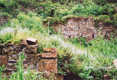
Photograph, Ruins of Coulstocks Mill, Janefield, South Morang
Mill Park Farm at Janefield on the Plenty River was established around 1840 by George Coulstock where he grew wheat. His flour mill was one of the first in Victoria, under construction as early as 1841. After bushfires and Coulstock's early death in 1842, the farm and its mill were taken over by local landowners Henry Miller and John Brock. Peter Hurlestone took charge of the mill. With water diverted from the Plenty River to fill the newly built Yan Yean Reservoir which opened in 1857, the Hurlestone family quit and that was the demise of the mill.Five colour photographs of ruins of Coulstocks Mill, Janefield (Mill Park - Bundoora)mills, flour mills, coulstock, janefield, plenty river, ruins, stone walls, bundoora, plenty gorge -
 Warrnambool and District Historical Society Inc.
Cards, Post Cards Warrnambool, Early 20th century
These cards have been sent to Christina Lawrance (1889-1970). She was born in Williamstown, Victoria and married James Robertson in 1912. They lived in the Gundagai area of N.S.W. on a property named ‘Nargoon’ (sheep and cattle) and they had five children. One of the daughters, Margaret, married Jeffrey (Bill) Whitehead of ‘Goodwood’ near Hawkesdale and the cards have been passed on to us from a Whitehead descendant. It is not known who sent the cards to Christina Lawrance who would have been 16 or 17 at the time. These cards are of interest because they are of Warrnambool scenes and demonstrate the practice at the time (1906) of sending cards that had photographs of local scenes. The photographs, although printed in great numbers, are of historical interest today. The cards are also of interest because of the recipient’s connection with the Warrnambool area – Christina Lawrance is an important person in the family tree of the Whitehead families today. These are four colour post cards in green, yellow and black tonings. They have photographs of the Hopkins River, Warrnambool and the Hopkins Falls on one side. They all have a penny red Victorian stamp and were posted from Warrnambool in 1906. The address is handwritten in black ink. Addressed to: ‘Miss C. Lawrance, C/O Kirkpatricks Hotel, Mornington, Victoria’whitehead family of ‘goodwood’, christina robertson nee lawrance, history of warrnambool and district -
 Victoria Police Museum
Police Stations (Apollo Bay)
Apollo Bay is a coastal town in southwestern Victoria. It is situated on the eastern side of Cape Otway, along the edge of the Barham River and on the Great Ocean Road, in the Colac Otway Shire. The original township was surveyed in 1853 and named Middleton. In 1881 the town was renamed Krambruk which was changed to Apollo Bay in 1898. The Krambruk Police Station was opened on 7 March 1888 in the Southern District on land opposite the site of the current Mechanics' Institute and changed its name to the Apollo Bay Police Station on 1 September 1990. It came under the Barwon District in 1948 and "Lima" Western District from 4 March 1990. In 1930 the police station was located to 29 Nelson Street. It was a seven-roomed weather-board dwelling on three-quarters of an acre of land. It consisted of six rooms of pine, lined and painted; one pantry; one bathroom and wash-house; one hall; one office and one W.C.. There was stabling for one horse and one cell for prisoners. It was staffed by one Mounted Constable. In the early 1970s land was acquired at 31 Nelson Street and a new police station was constructed. This was a three-roomed brick building with a cell block at the rear. By the time it closed in 2005 it had been extended twice. On 17 November 2006 the current Apollo Bay Police Station opened in its current location at 35a Nelson Street, on the corner of Cartwight Street). Outside the peak summer season, the station is open 16 hours per day and staffed by one sergeant and five other members. 3 black & white photos and 2 coloured photospolice stations; apollo bay police station