Showing 1783 items matching "settlement."
-
 Federation University Historical Collection
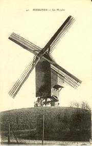
Postcard - Postcard - black and white, Le Moulin, Messines, c1914
Mesen (Messines in French, historically used in English) is a city located in the Belgian province of West Flanders. The municipality comprises of one main settlement, the town of Mesen proper. (Wikipedia) Two large battles were fought at Messines during World War One. Black and white postcard of a windmill at Messines, Belgium. chatham-holmes family collection, windmill, messines, moulin, world war, world war 1, world war one, belgium -
 Warrnambool and District Historical Society Inc.
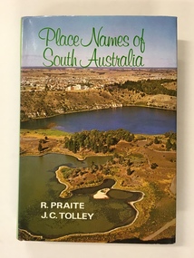
Book, Place Names of South Australia, 1970
This book gives information on the place names of South Australia and the origins of the names. It was compiled by Ronald Praite and John Tolley in 1970 and so is somewhat out of date as more place names would have to be added today. European settlement began in South Australia in 1836.This book is of minor interest to those in the Warrnambool area and may be useful for those researchers whose families have some connection to early South Australian history. This is a hard cover book of 208 pages. The cover is dark red with the names of the book and the authors on the spine. The dust cover has a colour photograph of a South Australian panorama on the front and a plain green back cover. The book has a Foreword, Sources of Reference, Acknowledgements, Introduction and an alphabetical listing of South Australian place names and the origins of the names. There are many black and white photographs supplied by the South Australian Tourist Bureau. There is some colour fading on the dust cover.Front Cover: ‘Place Names of South Australia’ ‘R.Praite’ ‘J.C.Tolley’ history of south australia, place names of south australia, ronald praite, john tolley -
 Heytesbury District Historical Society Inc.
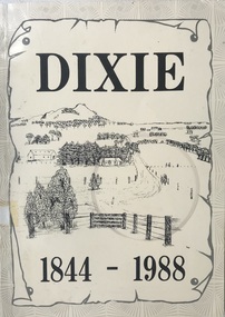
Book, Dixie 1844-1988
Paperback with black and white photographs, large map of County of Heytesbury inside back cover. An account of the settlement of the area known as Dixie in the County of Heytesbury, including pioneers, soldier settlers, the school, churches, sports club etc. during the period from 1844 to 1988. heytesbury shire - history, early settlement - south west victoria, dixie -
 Warrnambool and District Historical Society Inc.
Medallion, Stokes Melbourne, Centenary of Victoria 1935, 1933
This medal was given to Victorian school children to celebrate the centenary of European settlement in Victoria and the establishment of Melbourne in 1835. Portland was settled by the Henty brothers and John Batman and John Fawkner are the two names associated with the founding of Melbourne. The Melbourne Shrine of Remembrance was dedicated during these celebrations. This medal is a memento of the centenary of Victoria and may have been given a local Warrnambool school child. Circular silver coloured medal with ring at top and a further ring inserted. The obverse features a sailing ship entering a bay. Since "Portland " is part of the text it is assumed the bay is situated in Portland. Text The reverse features a hatted man wearing a suit and holding a walking stick standing on a grassy shore, a body of water and a sky line of buildings Obverse CENTENARY OF VICTORIA 1934 PORTLAND 1834 Reverse CENTENARY OF MELBOURNE 1935 1835 -
 Ballan Shire Historical Society
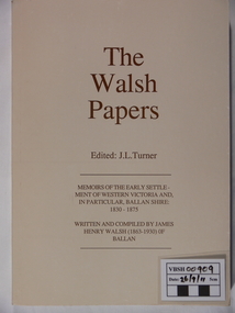
Book - Book. The Walsh Papers, The Walsh Papers, 1985
The former Shire of Ballan commissioned this work which ties in with the formation and early years of the Ballan Shire Historical Society. It is a collection of articles, works and memoirs written and compiled by James Henry Walsh, an early resident of Ballan, that have been edited for publication by James Turner. The book contains maps and photographs and is fully indexed. It is considered by some to be the foremost reference work on the history of Ballan.The book is significant as it is a comprehensive collection covering the history of Ballan. It is a limited edition and now out of print.A soft covered book, ivory in colour. Printed on the cover is - "The Walsh Papers. Edited: J.L.Turner. Memoirs of the early settlement of Western Victoria and, in particular, Ballan Shire: 1830 -1875. Written and compiled by James Henry Walsh (1863 -1930) of Ballan." The back cover is a full page sepia photograph of James Walsh (head and shoulders only) and the printed number "ISBN 0 95599911 1 5". Book No.106. 312 pages.The book bears the stamp of the Ballan Shire Historical Society and the handwritten marking "Receipt P.1." Book No.106 and Reg No. (VC) 00909 in pencil.walsh james henry, ballan memoirs, turner j l, ballan history -
 Bendigo Historical Society Inc.
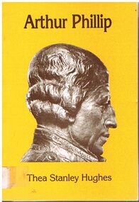
Book - ALEC H CHISHOLM COLLECTION: BOOK ''ARTHUR PHILLIP'' BY THEA STANLEY HUGHES
Book. ALEC H CHISHOLM COLLECTION. 112 page paper back illustrated biography of Arthur Phillip, first Governor of the Colony of NSW and the early settlement from 1787 to 1792. Front cover has a picture of a bust of Arthur Phillip. Published in 1982 by Movement Publications, Cabarita, NSW and printed by Star Printery, Erskineville, NSW. Catalogue sticker ''2148 HUG'' on spine. ISBN 0 908076 15 0.Thea Stanley Hughesbooks, collections, biography, alec h chisholm collection, thea stanley hughes, arthur phillip, history, biography, australiana -
 Ballarat Tramway Museum
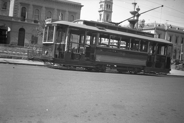
Negative, Wal Jack, 1938
Yields information about Ballarat 's No. 22 during 1938Set of two Negative and Digital images of the Wal Jack Ballarat Negative file of No. 22 in Sturt St at the corner of Lydiard St with the Post Office in the background, photograph during the Centennial celebrations of 1938, given the decorations in the background. Tram has the destination of Gardens via Sturt St West. Note the decorations in the for the centenary of settlement in the Ballarat district in 1938 - see Reg Item 5906 Two copies of the negatives on file.trams, tramways, sturt st, centenary, tram 22 -
Bendigo Historical Society Inc.
Article - JEWISH SYNAGOGUE JEWISH SETTLEMENT ON THE GOLDFIELDS OF VICTORIA, 1970
JEWISH SYNAGOGUE JEWISH SETTLEMENT ON THE GOLDFIELDS OF VICTORIA Two page article from the Jewish Geneological Society (Vic) Inc. Describes after 1851 was the turning point for settlers in the Port Phillip district. Sub headings: The Jewish life in Ballarat The first synagogue - 1855 A new synagogue for Ballarat - 1859 Eureka Stockade of 1854 Hebrew day School opened in 1870 Jewish population declines Bendigo (formerly known as Sandhurst)buildings, jewish synagogue, jewish synagogue, new synagogue -
![Painting: Park Street [Adeney Avenue] Kew](/media/collectors/550653872162f11fb04854aa/items/5826877cd0cdd11284ad5413/item-media/614ac683a53a0756fd5e49da/item-fit-380x285.jpg) Kew Historical Society Inc
Kew Historical Society IncPainting, Park Street [Adeney Avenue] Kew, c. 1896
‘Adeney Avenue’ was the title given to this painting following its donation to the Kew Historical Society, yet the work’s origins predate the naming of Adeney Avenue in 1907 [originally gazetted as ‘Park Street’ (1865) and ‘Park Street South’ (1875).] Park Street ran between High Street and Parkhill Road beside what was later to become ‘Victoria Park’. This area was described in 1851 as “…a dense forest of gums and wattles which were to be largely cleared by 1888 after the naming of a recreation reserve”. The Reserve was still bisected by an unnamed creek in 1896, when the area was surveyed by the MMBW. The panoramic vista selected by the artist would appear to include ‘Eborensis’ (c.1895) on the corner of Parkhill Road and what was then Park Street, with views across cleared land towards the distant ranges. In the 19th century, north Kew was largely undeveloped farms stretching down to the Yarra. Oil on canvas by an unidentified artist of a panoramic view depicting what is now known as East Kew with mountains on the horizon. In the foreground is a two storey brick residence - Eborensis - located on the northeast corner of Parkhill Road and what is now Adeney Avenue. The view of the landscape and its rolling hills resulted from farming practices adopted following colonisation and settlement. Trees in the foreground and in the distance include remnant Eucalypts and introduced exotics.Label on rear of frame states "House on corner of Adeney Ave & Parkhill. [Regd. 254"]. Otherwise unsigned and undatedadeney avenue (kew), eborensis, park street (kew) -
Greensborough Historical Society
Book, Melbourne Water, Plenty River Waterway Management Activity Plan 2000, 2000_
This report covers the catchment of the Plenty River from its upper reaches in the Great Dividing Range to the confluence with the Yarra River at Viewbank. It discusses ecological diversity and methods of improving water quality and significant areas of the catchment. Includes a brief history of settlement along the Plenty River.This is a significant plan for the improvement of the Plenty River.207 p., maps, folding maps. Printed on white paper with black spiral binding and clear plastic front cover.plenty river, melbourne water -
 Sunbury Family History and Heritage Society Inc.
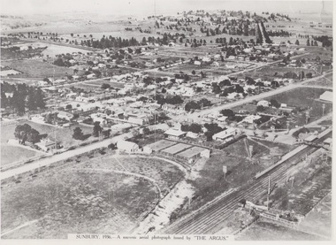
Photograph, 1936
The aerial view of Sunbury was featured in The Argus newspaper in 1936 in recognition of 100 years of European settlement of the area. It shows the extent of the township in 1936 which extended from the railway line in the west to the Jackson Creek in the east and the Sunbury Asylum in the south and northwards towards Macedon Street. The photograph was taken when Sunbury was a country settlement 25 miles ( 37 kms) from Melbourne. Since the 1980s the area grown rapidly and is now an outer suburb of Melbourne.A black and white aerial photograph with a cream border of the Sunbury township. SUNBURY 1936 - A SOUVENIR AERIAL PHOTOGRAPH ISSUED BY THE ARGUS.aerial photographs -
 Port Fairy Historical Society Museum and Archives
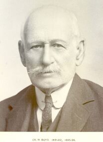
Photograph, Cr William Boyd Shire of Belfast President 1891-92 95-96
Councillor William Boyd was the son of Alexander Boyd who emigrated from Scotland and purchased the property known as Tarrone station in 1884. William managed the station grazing cattle and sheep. The area was later to become part of the Soldier Settlement land after the Second World War.Black and white portraitbelfast, president, government, portrait, shire, council, municipal, local-government, tarrone -
 Kiewa Valley Historical Society
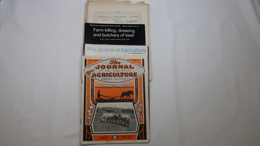
Journals - Department of Agriculture, 1. 1950s and 2. one 1932 & others 1970s
The Kiewa Valley has been a farming district from early settlement of white people. This has continued until the present although the nature of farming has varied over the years. Access to information has improved with transport and technology. The journals kept the farmers informed and up to date.These booklets and journals were one of the few sources of information during the 1950s for the isolated farmers of the Kiewa Valley. The Kiewa Hydro Electric Scheme improved both transport and technology during the scheme's construction from the 1940s. It provided the township of Mt Beauty at the upper end of the valley where shops and schools were constructed, roads were improved out of the valley and the supply of electricity for milking etc. became available. 1. 14 articles each bounded by 2 staples, and each reprinted from Dept. of Agriculture Journal on a particular topic relating to Agriculture. All black & white and c1950s. 2. 4 Journals with colored covers 3 from Victoria Dept. of Agriculture (1932, 1974 & 1975) and 1 from Sth. Australia.1. "J.H.Wallace" hand written top right corner of covers of pamphlets titled 'Diseases Affecting /Young Cattle' and 'Mastitis'. "AHW" hand written top right corner of cover of pamphlet titled ' Grading Land for Irrigation' 2. Nonefarming, agriculture, cattle, pasture, kiewa valley, department of agriculture in victoria, kiewa hydro electric scheme, -
 Ballaarat Mechanics' Institute (BMI Ballarat)
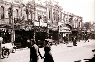
Centenary Decorated Bridge St shops
This photograph is from the Max Harris Collection held by the Ballaraat Mechanics' Institute. Please contact BMI for all print and usage inquiries. In 1938 Ballarat celebrated 100 years since white settlement with a city wide floral festival and parade. Businesses decorated their shops with elaborate displays. ballarat, centenary, decorated, bridge st, shops, floral festival -
 Nillumbik Historical Society Incorporated
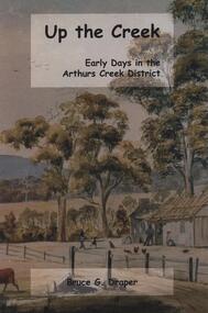
Book - Softcover book, BookPOD, Up The Creek Early Days in the Arthurs Creek District, 2018
A collation of reminiscences, anecdotes and recorded histories of the pioneer families and their descendants in Arthurs Creek, Victoria by Bruce Draper. From the back cover "Up the Creek is a window into the community spirit and achievements of former generations. This book is an enduring legacy to the families who were pivotal to the early settlement of Melbourne."Softcover book with a part of the painting "Arthurs Creek" by Harry Harwood (1878) wrapped around the front and back covers in green and blue tones, black lettering and 144 pages.#arthurscreek, #localhistory, #arthurscreekfamilies -
 Ballarat Heritage Services
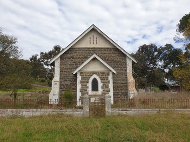
Photograph, Clare Gervasoni, St James' Anglican Church, Bowning, New South Wales
St James Anglican Church Bowning was built c.1878. Bowning is one of Australia's earliest settlements, this village is home to a renewed and growing community. It lies at the foot of the 796 metre Bowning Hill which gives a good idea of how early explorers and settlers saw the area.Photograph of a weatherboard church in Bowning, New South Wales/st james bowning, anglican church, bowning -
 Ballarat Heritage Services
Photograph, Clare Gervasoni, Former St Columba's Catholic Church, Bowning, New South Wales, 05/05/2022
St James Anglican Church Bowning was built c.1878. Bowning is one of Australia's earliest settlements, this village is home to a renewed and growing community. It lies at the foot of the 796 metre Bowning Hill which gives a good idea of how early explorers and settlers saw the area.Photograph of a weatherboard church in Bowning, New South Wales/bowning, former st columba's catholic church, rev. j. gallagher, rev. j.f.le nard -
 Kiewa Valley Historical Society
Book - Bogong High Plains x2, Early History and Discovery of the Bogong High Plains, 1968
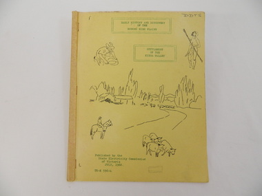
The State Electricity Commission of Victoria constructed the Kiewa Hydro Electric Scheme in the north east of Victoria. Mr R.M. Duncan prepared the notes. He was a member of the S.E.C. Kiewa Branch from 1949 - 1966. This book was commissioned by the State Electricity Commission of Victoria. It consists of the early history of the Bogong High Plains and the origin of names of places and creeks in the area.This book was researched in 1968 by Mr R.M. Duncan who worked for the S.E.C. on the Kiewa Hydro Electric Scheme from 1949 to 1966. His sources were the Melbourne Public Library, the Victorian Historical Society, the North Eastern Victorian Historical Society and the Dept. of Crown Lands & Survey, Melbourne. The book is an accurate history of the Bogong High Plains given the available records at the time. Yellow cardboard covered book with black sketches and green print. 9 one-sided pages held together by 3 staples and taped over the staples. One - has sheets enclosed "The Three Floras of Bogong" and "General Geology of the Kiewa Area". 6 copies including 1 that is a photocopyDDTS hand written on front cover "Early History and Discovery / of the / Bogong High Plains" on cover top centre. "Settlement / of the / Kiewa-Valley" on cover towards the top slightly to the right. "Published by the / State Electricity Commission / of Victoria / July, 1968" on cover bottom left. "TR-K 596-4" on cover bottom left.bogong high plains. state electricity commission of victoria. kiewa. aborigines. kiewa valley. mullindollingong pastoral run. flora. geology -
Federation University Historical Collection
Booklet, The Stock Exchange of Melbourne: Monthly Official List of Quotations and Prices Current, 1909, 1909
Small, brown, soft covered booklet. Contents include brokerage, Closer Settlement Loans. Banks. Building Societies, Banking and Financial Institutions, Gas, Insurance, Breweries, Trustee, mines, Goldmines in Ballarat, Daylesford, Stawell and District, Dredging Companies, Coal mines, Municipal Loans, Metal Rates since 1888, Calls Due 13 January 1909, List of Legal Managers and Secretariat of Mining Companies, Member of the Melbourne Stock Exchange.non-fictionmelbourne stock exchange, stockbrokers, f.w. holst, w.s. ham, walter s. ham, f.w. were, r.e. tweddell, w.d. thompson, w.m. williams, n.m. dudgeon, w.m. acheson, e.g. ross, j.h. dill, s. stretch, j.c. bell -
 Bendigo Historical Society Inc.
Document - H.A. & S.R. WILKINSON COLLECTION: CONDITION OF SALE
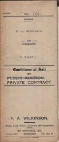
Conditions of sale by private contract dated 12th May, 1932 between H.A. Wilkinson (seller) and S. Rigby (buyer) for land within the special settlement area situate Junortoun containing 17 acres, 1 rood, 27 perches being allotment 37F Parish of Wellsford, County of Bendigo described in Crown grant volume 4485 folio 896958, together with 4-roomed weatherboard dwelling and all sundry. Price 575 pounds.organization, business, h.a. & s.r wilkinson real estate -
 Warrnambool and District Historical Society Inc.
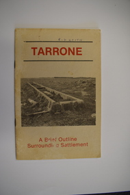
Booklet, Tarrone, 1983
A brief outline of the history of the Tarrone estateThis is a booklet of 20 pages. It has a buff-coloured cover with two black and white photographs and red print. The pages contain black and white photographs, printed text, maps and illustrations. The booklet is stapled non-fictionA brief outline of the history of the Tarrone estatesoldier settlements post world war two, tarrone estate -
 The Foundling Archive
Book, One Fella Lost, c.1920-1940
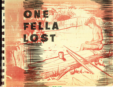
Picture story book written by Mission teacher, Miss Muriel Burthon, with illustrations based on drawings by Nugget James, from the Baptist Mission, Warrabri Native Settlement, Northern Territory. The book is published by Mission Publications Australia. This book states its uses as: as a story book and as an evangelizing tool. Historic Significance: this item reflects the nature of the relationship between Indigenous residents of Aboriginal missions and the mission masters. It provides an indication of the perception and representation of indigenous Australians during the early to mid- 20th Century. This item is a tangible reminder of the systematic captivity of indigenous Australians across the late 19th and 20th Centuries. Ring-bound paperback publication."One/Fella/Lost"aboriginal mission, indigenous history, colonialism, christianity, -
 Mt Dandenong & District Historical Society Inc.
Photograph, Barber's Bridge on Olinda Creek
John Lundy-Clarke grew up in the Kalorama/Mt Dandenong area and later in life (1972-74) began to write a comprehensive history of the area working from an original settlement map in an effort to cover all areas. Barbers Bridge was named after George Barber, an early settler.Black and white photograph showing a man standing on a bridge over the Olinda Creek. 1910Handwritten n reverse: Barbers Bridge on Olinda Creek 1910. This was a ford crossed by the road after Isaac Jeeves selected allotment “C” “Jeeves Saddle” in 1871 and stopped travel through his property. The bridge has been built several times but at time of writing (1974) is replaced by a culvert consisting of two pipes two feet six inches wide. They are quite incapable of carrying the maximum flow of the creek and will be swept away.lundy-clarke, barber, barbers bridge, isaac jeeves, jeeves saddle, bridge, olinda creek -
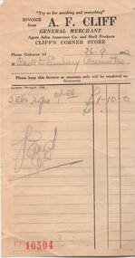 Sunbury Family History and Heritage Society Inc.
Document
In 1952, the local Sunbury Progress Association sponsored the 'Back to Sunbury' celebrations which were held from 13th to 20th September 1952. The festivities celebrated 100 years of settlement (white) and provided a time for many long-time residents to get together. A.F. Cliff was businessman in Gisborne.A sales docket for £1.10.0 made out by A.F.Cliff, dated 26/9.52 for the sale of 5lbs of . . . . The purchaser was the Back to Sunbury Committee. Invoice A.F. CLIFFback to sunbury, celebrations, a.f. cliff -
Glenelg Shire Council Cultural Collection
Book, People of the Lake - the story of Lake Condah Mission, n.d
27,000 years ago molten lava pouring from the eruption of Budjbim (Mt. Eccles) formed Lake Condah and the unique landscape that surrounds it. Over time this area known as "The Stony Rises" or "The Stones" became an important geological area for Koories and, later, Europeans.12 page A4 size booklet, cream with brown print.27,000 years ago molten lava pouring from the eruption of Budjbim (Mt. Eccles) formed Lake Condah and the unique landscape that surrounds it. Over time this area known as "The Stony Rises" or "The Stones" became an important geological area for Koories and, later, Europeans.aboriginal history, gunditjmara, lake condah, mission history, budj bim -
 Phillip Island and District Historical Society Inc.
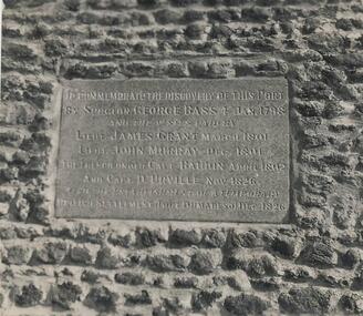
Photograph, 1923
One of a collection of over 400 photographs in an album commenced in 1960 and presented to the Phillip Island & Westernport Historical Society by the Shire of Phillip IslandClose up photograph of the Woolamai Granite Tablet on the Cairn at Rhyll.To Commemorate the discovery of this port by Surgeon George Bass, 4 Jan 1798 and the visits paid by Lieut. James Grant, March 1801. Lieut. John Murray, Dec 1801. The French under Capt. Baudin, April 1802 and Capt. D'Urville, Nov. 1826. Also the establishment of a temporary British settlement (Fort Dumaresq) Dec. 1826 local history, photography, tablet on the rhyll cairn, black & white photograph, rhyll cairn, george bass, exploration, john jenner, bryant west -
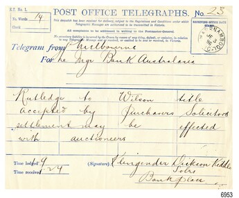 Flagstaff Hill Maritime Museum and Village
Document - Telegraph, Klingender Dickson and Kiddle, solicitors, 3-6-1896
The telegraph system of sending and receiving messages was developed in the early 1800s and improved as time went on. It sends electronic signals that represent letters and words along a wire. Those signals are then converted back to words at the other end of the wire. Morse code is a similar system. A fee is charged to send a telegraph, per letter or per word. The telegraph greatly improved communication, particularly in a large country like Australia. It was a fast way to send news and send out calls for help for people during a shipwreck. In Warrnambool, it was even used to set the correct time every day; a signal was sent from the time ball in Melbourne, and along the railway line to the Warrnambool Post Office. This 1896 telegraph tells a big story in very few words, only fourteen! The layout of the paper form includes a table with four columns and five rows, set out for writing just one word into each of the twenty spaces. The happy message is the approval to go ahead with the exchange/sale of the title from landowner Rutledge to Wilson. The Melbourne Legal firm Klingender Dickson and Kiddle sent this message on behalf of its client to the Bank of Australasia in Warrnambool. The Bank of Australasia was incorporated by the Royal Charter of England in March 1834. The bank began in Australia on 14th December 1835, opening in Sydney. The Acting Superintendent of the bank at that time was David Charters McArthur. He was Superintendent from 1867-to 1876. The Melbourne branch opened on 28th August 1838 in a two-roomed brick cottage on the north side of Little Collins Street, where two huge mastiff dogs were used at night to guard the bank. The government also provided an armed military sentinel. Due to the bank's rapid growth, a new building for the Melbourne branch was opened in 1840 at 75 Collins Street West. By 1879 the bank had been upgraded to a magnificent two-storey building on the corners of Collins and Queens Streets, with the entry on Collins Street. In 1951 the Bank of Australasia amalgamated with the Union Bank to form Australia and New Zealand Bank, now known as the ANZ. Then in 1970, the ANZ merged with both the ES&A and the London Bank of Australia to form the ANZ Banking Group Limited. The ANZ Banking Group Ltd kindly donated a variety of historic items from the Bank of Australasia. BANK of AUSTRALASIA, WARRNAMBOOL – In 1854 Warrnambool had two banks, the Union Bank and the Bank of Australasia. Later, completely different bank businesses opened; in 1867 the National Bank of Australasia, then in 1875 the Colonial Bank of Australasia. The original Warrnambool branch of the Bank of Australasia was established in July 1854, and operated from a leased cottage on Merri Street, close to Liebig Street. The bank later bought a stone building previously erected by drapers Cramond & Dickson on the corner of Timor and Gibson Streets. Samuel Hannaford was a teller and then Manager at the Warrnambool branch from 1855 to 1856 and the Warrnambool Council chose that bank for its dealings during 1856-57. In 1859 Roberts & Co. was awarded the contract to build the new Bank of Australasia branch for the sum of £3,000. The land was on a sand hill on the northeast corner of Timor and Kepler Streets and had been bought in 1855 from investor James Cust. The new building opened on May 21, 1860. The bank continued to operate there until 1951 when it merged with the Union Bank to form the ANZ Bank, which continued operating from its Liebig Street building. Warrnambool City Council purchased the former Bank of Australasia building in 1971 and renovated it, then on 3rd December 1973 it was officially opened as the Art Gallery by Cr. Harold Stephenson and Gallery Director John Welsh. The Gallery transferred to the purpose-built building in Liebig Street in 1986 and the old bank building is now the Gallery club. Staff at the Bank of Australasia in Warrnambool included the following men but others were also involved: Samuel Hannaford, Teller then Manager from 1855-1856; W H Palmer, Manager from January 1857 until November 1869 when the Teller Basil Spence was promoted to Manager; H B Chomley, Manager from April 1873 and still there in 1886; A Butt, Manager in 1895-1904; J R McCleary Accountant and Acting Manager for 12 months, until 1900; A Kirk, Manager 1904; J Moore, staff until his transfer to Bendigo in December 1908; J S Bath was Manager until 1915; C C Cox, Manager until April 1923; Richard C Stanley, Manager 1923 to April 1928. This telegraph has historical significance as it was sent to the Bank of Australasia in Warrnambool. The parties involved in the message, Rutledge and Wilson, were involved in a land deal in 1896 when the district was importing and exporting goods into and out of Warrnambool Harbour via sailing ships. It is also a historical record of the nature of financial agreements between similar institutions in Warrnambool and the district. The telegraph is significant for its association with the Bank of Australasia in Warrnambool, the first bank in Warrnambool, established in 1854. The bank continued to operate until its merger in 1951 when it became the ANZ Bank, which is still in operation today. The Bank was an integral part of the establishment and growth of commerce in Colonial Warrnambool and throughout Australia.Telegraph RECEIVED: Warrnambool Post Office, Wednesday 3rd June 1896. FROM: Klingender, Dickson, and Kiddle, solicitors, Bank Place, Melbourne FOR :the Manager, Bank of Australasia, Warrnambool, REGARDING: Rutledge to Wilson titleSTAMP: text inside circle "WARRNAMBOOL VIC", and in centre of the circle "JE 3 96" Telegraph No. "23", FROM :"Melbourne", FOR: "The Mgr, Bank of Australasia" MESSAGE (14 words): "Rutledge to Wilson title accepted by Purchaser's Solicitors settlement may be effected with auctioneers" TIME: "9:24" SIGNED: " Klingender Dickson Kiddle, Solrs, Bank Place"flagstaff hill, warrnambool, flagstaff hill maritime museum, maritime museum, commerce, banking, bank of australasia, australia & new zealand bank, anz bank, david charters mcarthur, telegraph, 1896, rutledge, wilson, klengender, dickson, kiddle, warrnambool post office, klengender dickson and kiddle, bank place -
 Lara RSL Sub Branch
Booklet, Sgts' Mess Royal Air Force Brize Norton, R.A.F. Station, Oxfordshire, U.K, circ 1939
Sargent's, Mess Royal Air Force, Brize Norton Royal Air Force Brize Norton or RAF Brize Norton in Oxfordshire, about 65 mi (105 km) west north-west of London, is the largest station of the Royal Air Force. It is close to the settlements of Brize Norton, Carterton and Witney.Sgt's Mess Royal Air Force Brize Norton, R.A.F. Station, Oxfordshire, U.K. - Rules of Sergeant's Mess -
![Map - Maps, [John Batman in Melbourne], 1976](/media/collectors/4f729f5697f83e03086015b8/items/60965f673c71fad916b3a651/item-media/60965fc33c71fad916b3a805/item-fit-380x285.jpg) Greensborough Historical Society
Greensborough Historical SocietyMap - Maps, [John Batman in Melbourne], 1976
Photocopies of 4 maps showing aspects of John Batman's time in Melbourne: Map of the settlement of the Yarra 1837; Batman's map of Port Phillip and his route of exploration, 1835, drawn by Wedge; Proposed route of Batman's initial exploratiion, and Enlargement of the Geelong region of Batman's map. No citations on any copy.Photocopy of maps, 4 pages.john batman, melbourne, port phillip -
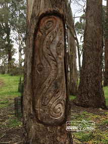 Eltham District Historical Society Inc
Photograph, Peter Pidgeon, Killeavey, Laughing Waters Road, Eltham 5 Nov 2016, 5 Nov 2016
This carving represents the eels and eel trap which was discovered by Cam in the Yarra below Killeavey and has been established to be ore European settlement. The Wurundjeri built the eel trap in an area where the eels gathered and has proven to still be highly effective today Heriitage Excursion - Kileavey Walk and TalkBorn Digitalactivities, eltham district historical society, heritage excursion, kileavey, parks victoria, laughing waters road, eltham, wurundjeri