Showing 13710 items
matching wye-river-bridge
-
 Ballarat Heritage Services
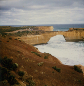
Photograph, London Bridge, Great Ocean Road, 01/1990
London Bridge, pre 1990 was a double-spanning bridge connected to the mainland. The stack was created over hundreds of years, with the weaker layers toward the base being eroded away by wind and water to form the two bridges. The span closer to the shoreline collapsed unexpectedly on 15 January 1990, leaving two visitors, whilst uninjured, stranded on the outer span before being rescued by helicopter. Two coloured photographs of the London Bridge, on the Great Ocean Road. This photo was taken days before the collapse of the geological feature. The photographer walked across the bridge to the warning of her mother "if you go over there and it collapses you will be stuck. After the collapse it was renamed London Arch. london bridge, great ocean road, london bridge, peterborough, london arch, shipwreck coast, 12 apostles -
 Lorne Historical Society
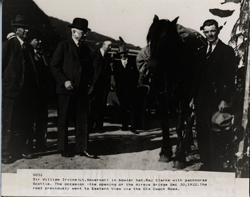
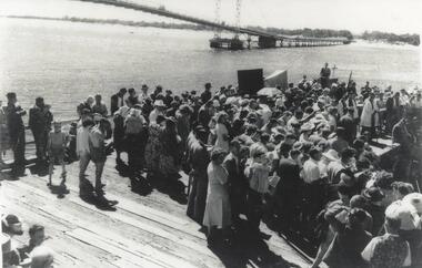
Photograph, Opening of Aireys Bridge 30 December 1932
Photograph of Sir William Irvine (Lt Govenor) at the opening of Airey's BridgePhoto of Sir William Irvine (Lt. Governor) at opening of Airey Bridge. 30th December 1932aireys bridge; sir william irvine, lt govenor, 30.12.1932 -
 Sunbury Family History and Heritage Society Inc.
Photograph, Bulla Bridge
A coloured photograph of the bluestone bridge which spans Deep Creek at Bulla. The photograph is taken facing upstream. The bridge was constructed in 1869 and replaced a ford crossing further downstream. Many bridges in the South West of Victoria were constructed from Bluestone basalt rock because the area is on a large volcanic plain and that rock is in abundance. A coloured photograph of the Bulla Bridge which spans the Deep Creek at Bulla. Photograph 0178 is an identical photograph tho this one.bridges, bulla bridge -
 Wodonga & District Historical Society Inc
Album - Ringer's River by Des Martin - Plate 12 - A positive result from the customs duty
Meantime back at Camoola "Top Or Nothing" Price, known to stockmen as "Old Stop At Nothing", and his shifty ex-jockey clerk Billy Matthews, have been stunned by the Victorian customs duty of 30 shillings per head on cattle, and 50 shillings per head on horses, suddenly promulgated just prior to a very important sale. Caught with a lot of cattle he cannot unload, and a property sale that has gone astray, Price accepts offers for both from O'Day, who thus sets himself up cheaply with a good holding that runs down Barmagulla's back boundary to the Murray River at the point where he often swims across.The album and images are significant because they document literature written by a prominent member of the Wodonga community. The presentation of this precis was supported by several significant district families and individuals.Ringer's River Album Coloured photo Plate 12des martin, many a mile, ringer's river, northeast victoria stories -
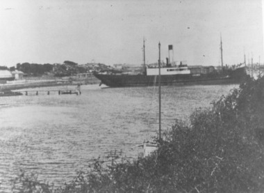 Port Fairy Historical Society Museum and Archives
Photograph
This shows the S.S.Wannon turning in the specially widened part of the river called the "turning basin" before slipping into her berth at the Belfast and Koroit Steam Navigation Company wharfBlack and white photograph of SS Wannon turning in the Moyne Rivership, boat, sea, moyne river, belfast and koroit steam navigation company, turning basin -
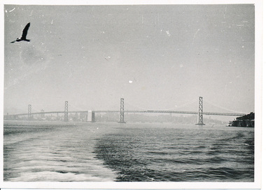 Mission to Seafarers Victoria
Photograph - Photograph, Black and white, Allan Charles Quinn, The Bay Bridge, 12 November 1949
This photograph is part of series depicting Allan Quinn's travels through San Francisco in 1949. This photograph is a landscape shot of the San Fransisco Oakland Bay Bridge.This is a photograph from the Allan Charles Quinn collection which is a collection of letters and photograph depicting aspects of life at sea for a young man in the era immediately following World War II.A black and white photograph of the San Francisco Bay and the Oakland Bay Bridge.Reverse: 12-11-49 handwritten in blue ink. Below this are some indecipherable marks in pencil.allan-quinn, photograph, san-francisco, bay-bridge, 1949, merchant navy -
 Wodonga & District Historical Society Inc
Album - Ringer's River by Des Martin - Plate 35 - Moves towards Federation
With Federation all but a fact Alfred Deakin is again in the Overton area but his meeting has been cancelled. While Montieth is getting some stores he and MacLough observe the drama on the bridge from the nearby Post Office verandah. Coming on top of the deaths of the O'Haras these scenes appal Deakin. In reply to MacLough he says that Federation will do away with the border, and bring free trade between the states of the new Australian Commonwealth. This will permit O'Day to come home as a free man. MacLough queries the fine and Deakin says that it must be paid, but he will have it reduced to £200. On hearing this MacLough declares he will pay the fine himself, and give O'Day a half share partnership in Gooloora as well.The album and images are significant because they document literature written by a prominent member of the Wodonga community. The presentation of this precis was supported by several significant district families and individuals.Ringer's River Album Coloured photo Plate 35des martin, many a mile, ringer's river, northeast victoria stories -
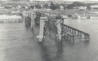 Phillip Island and District Historical Society Inc.
Photograph, Phillip Island Bridge, 1968/9
1969 2nd Phillip Island Bridge under construction. Suspension Bridge demolished early 1970 From the Jack Jenner CollectionConcrete stanchions and scaffolding of new Bridge part built.(opened 1969). Taken from other half looking towards San Remo.local history, photographs, civil engineering, bridges, phillip island bridges, black & white photograph, jack jenner collection, public construction -
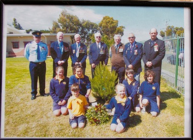 Lara RSL Sub Branch
Framed Picture, Little River School Remeberance Day 2012, 2012
Dedication ceremony at the Little River Primary School for Rememberance Day 2012 RSL members from Left to Right were Walter Sherman, Ken Simmons, Snow Beswick, Bruce Challoner, Daryl Anderson, Alwyn Leech, Don ScownDedication Ceremony Rememberance Day 2012 Little River Primary SchoolFramed coloured photo in a plastic glass frame MDF backRear of Photo Frame " Little River School 12-11-2012 Remeberance Day Ceremonyphotograph little river primary rememberance day 2012 -
 Eltham District Historical Society Inc
Photograph, Doug Orford, Bridge Street Bridge, Eltham
Two colour photographs of Bridge Street Bridge over Diamond Creek, Eltham showing bridge sub-structurebridges, diamond creek, eltham, bridge street -
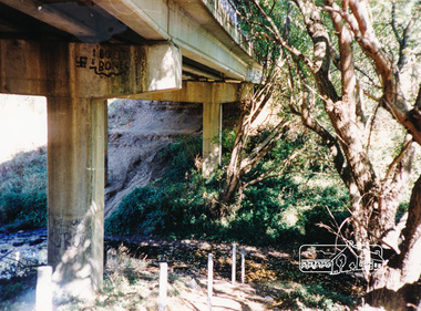 Eltham District Historical Society Inc
Photograph, Doug Orford, Bridge Street Bridge, Eltham
Two colour photographs of Bridge Street Bridge over Diamond Creek, Eltham showing bridge sub-structurebridges, diamond creek, eltham, bridge street -
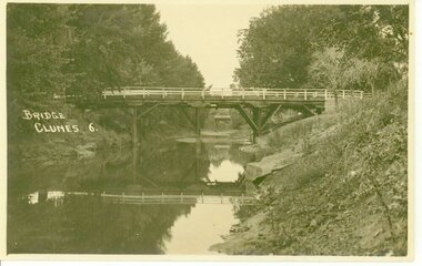 Clunes Museum
Photograph, D.S. KING
BRIDGE OVER CRESWICK CREEKBRIDGE OVER CREEK "BUTTER FACTORY" BRIDGE AT THE FOOT OF CAMERON ST. CLUNES.BRIDGE. CLUNES 6local history, document, postcard, bridges -
 Melbourne Tram Museum
Photograph - Digital Image, Kevin O'Reilly, series of three images of the Hawthorn Bridge over the Yarra, c1930, c1930's
Image from CD (Compact Diskette for use in computers) - see Reg Item 135. A series of three images of the Hawthorn Bridge over the Yarra, c1930, during the era with problems with the bridge. See separate article for more details. Richmond 6, Richmond, Richmond 3 on the CD as original files. .1 - Looking from the south west, at the Hawthorn bridge with the temporary wooden bridge being constructed on the south side. Has the cable tram depot in the photo and part of the Burnley racing course. Temporary track on the north side of the steel bridge and crossings can be seen. .2 - Looking along Bridge Road to the east with Hawthorn Bridge in the middle of the photograph. Shows the industrial and residential areas, Hawthorn Railway Station and part of the Burnley Race course, the cable tram depot building. W class tram in Church St Hawthorn and W class tram crossing the bridge on the north side temporary track. Note the cable tram used as a shelter on the north east corner of the bridge. .3 - Looking south along River St towards Bridge Road, with the Yarra River and Hawthorn Bridge on the left side of the photograph. Shows the industry in the area at the time, wool and skin Merchants, north side of the cable depot, housing and the outlook to the river!trams, tramways, hawthorn, yarra river, burnley, richmond, hawthorn bridge -
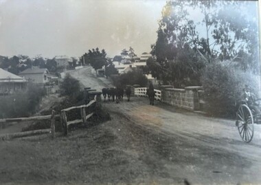 Greensborough Historical Society
Photograph - Photograph (Framed), Herding stock over blue stone bridge looking up Main Street Greensborough
Heading stock over Blue stone bridge looking up Main Street Greensborough. In this photograph, Greensborough was a country town. Note the unmade road leading up to the bridge.From the John Mackey collection. This item was displayed at the offices of Ryan, Mackey and Kelly, solicitors, Main Street Greensborough.Timber-framed photograph of herding stock over blue stone bridge looking up Main Street Greensborough, black and white.greensborough, john mackey, blue stone bridge, marble hall -
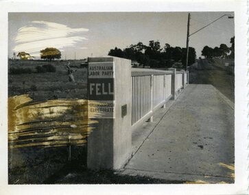 City of Whittlesea
Photograph - Photographs - Bridges, Photograph - Bridge - Bundoora, 1967
Bridge over Darebin Creek, Settlement Road Bundoora. Looking west towards Thomastown, April 1967. Bridge post includes Australian Labor Party election poster for Greensborough Electorate. Bob Fell was the ALP candidate at the 1967 state election which he lost.Photographs, black and white print on paper. Bridge over Darebin Creek, Settlement Road Bundoora 1967. -
 Melbourne Tram Museum
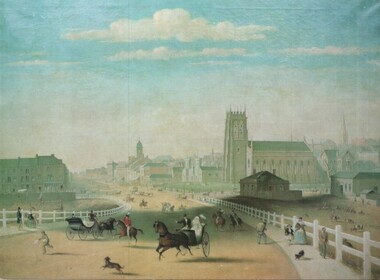
Artwork, other - Swanston Street from Princes Bridge c1861
Colour print of Reproduction of an oil painting - Swanston Street from Princes Bridge c1861 showing Johnson's Bridge Hotel, later Young and Jacksons, the first St Paul's church building, original Town Hall building and the tower of Scots church. Shows pedestrians and horse drawn carriages before the introduction of public omnibus services in 1869. Not known who produced the card.Yields information about early Melbourne after the start of the gold rush.Reproduction of an oil painting - Swanston Street from Princes Bridge c1861 by Henry BurnIn ink on the rear Keith Kings stamp and the initials RG and "Melbourne"melbourne, princes bridge, horse drawn vehicles, st pauls cathedral, hotels -
 Buninyong Visitor Information Centre
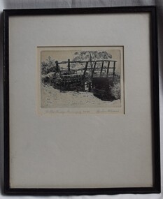
Print - Engraving, The Old Bridge, Buninyong No. 24
The location of the bridge has not yet been identified but further investigations will continue, as will details of when the work was completed by Graham Hopwood.A significant images of an early local structure in Buninyong. Requires further research.Engraving of a rough old timber bridge in Buninyong by artist and art educator, Graham Hopwood.Hand written on the backing paper of the frame: 'Originally owned by JM Matheson, given to Marjorie Matheson, 1956, Olympic Games'.graham hopwood, bridges, engravings, topographical art, buninyong -
 Greensborough Historical Society
Photograph Collection, Richard Pinn, Plenty River 1979, by Alan Pinn, 1979_
Photographs of the Plenty River Greensborough. One shows Richard Pinn walking his dog (Jah) on track by river, the second photo is a close up of the Greensborough Bluestone Bridge and steps to river. The bridge has since been demolished and the path replaced by a concrete bike/walking path.Shows the river pathways and bluestone bridge in the 1979.2 b&w photographs.plenty river, greensborough, richard pinn -
 Phillip Island and District Historical Society Inc.
Photograph, Suspension Bridge, 1940
Official opening of Suspension Bridge 1940. Opened by Hon. Albert Dunstan LMHCrowd on work platform. View of new Suspension Bridge at Official Opening. Priest at Lectern at middle right. local history, photographs, civil engineering, bridges, official bridge opening, black & white photograph, jack jenner collection, phillip island bridges, public construction -
 Orbost & District Historical Society
black and white photograph, Howard D. Bulmer, first half 20th century
A new bridge over the Snowy River at Orbost was opened for traffic on June 20th 1922. It was intended as a road and rail bridge, and was again partly washed away by flood waters in 1934. After the end of the first World War the Victorian Railways considered an extension of the railhead across the river at Orbost, and in 1922 a new timber and steel girder structure, a joint Country Roads Board — Victorian Railways venture, was built and completed at a cost of £41,000 (the steel girders came from the Flinders Street viaduct reconstruction). Subsequently it was decided decided not to take the railway across the river, and the bridge was only used by road traffic. This is a pictorial record of an early bridge over the Snowy River at Orbost.A black / white postcard photograph of a bridge across a shallow river with men on horseback underneath.snowy-river-bridge -
 Orbost & District Historical Society
black and photograph / postcard, 1.4.1908
This postcard was sent to Annie Gilbert (Mrs John Gilbert) of Tullagoota, Orbost. It was written by "Grace", probably her sister, Grace Cameron Annie Gilbert was the daughter of John Cameron who selected the first land on the Snowy River flats. This is a photograph of the original Orbost / Snowy River Bridge , a suspension bridge which opened in 1893. It has been taken when the Snowy River was in flood. It is similar to other photographs held in The State Library, Victoria. The Snowy River Mail and Tambo and Croajingolong Gazette Sat 12 Aug 1893 records the opening of this bridge as "the most important public event that has yet been commemorated in Eastern ......The Messrs McLeod, with whom the first settlement of this district is generally associated, took up their residence on the eastern bank of the Snowy River about the year 1841 or 42. The late Mr W. Roadknight and Mr T. T. Stirling took possession of the territory on the western side of the Snowy about 35 years ago. During the occupation of the country by cattle owners, very little progress was made in the way of roads and bridges, and except to the hardy and lexperienced bushman, it might have been generally regarded as inaccessible. About the year 1877, however, the late Mr James Robertson eldest son of Mr James Robertson, of Lochend farm, selected land now occupied by his father, about four miles from Orbost on the west bank of the river, Mr John Cameron visited the. district shortly after a .tour of inspection and returned later with his brothers, James and Alick Gameron, but found that during their absence Mr Ernest Watt had found his way on the scene and pegged out a selection, thus anticipating the advent of the Camerons by about 12 hours. We understand that a Mr Kidd, who selected the property now occupied by Mr W. J. Ross, at Pumpkin Point, was one of the earliest batch of settlers.........."This item is associated with Annie Gilbert (nee Cameron) reported to have been the first white girl to be born in Orbost. It is a pictorial record of the suspension bridge over the Snowy River which has since been replaced twice.A faded black / white postcard of a bridge across a river. There are cattle in the river and the banks are tree-covered.on back - a hand-written letter addressed to Mrs J. Gilbert Tullagoota Orbost.cameron-annie suspension-bridge-orbost snowy-river-orbost -
 Wodonga & District Historical Society Inc
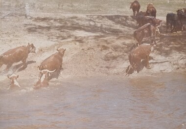
Album - Ringer's River by Des Martin - Plate 30 - Cattle cross the river to New South Wales
When morning comes all the cattle have struggled back to N.S.W. and the Victorian police find their trap is empty. O'Day, though he has lost his horse, makes it to the far bank some 400 yards downstream. Of Erin and Keiran there is no sign.The album and images are significant because they document literature written by a prominent member of the Wodonga community. The presentation of this precis was supported by several significant district families and individuals.Ringer's River Album Coloured photo Plate 30des martin, many a mile, ringer's river, northeast victoria stories -
![Waterfall Scene on the Coliban River, near Elphinstone / [by] Nicholas Caire, circa 1876](/media/collectors/550653872162f11fb04854aa/items/577b4d42d0cdd10948c96acf/item-media/577b4dbfd0cdd10948c9b34f/item-fit-380x285.jpg) Kew Historical Society Inc
Kew Historical Society IncPhotograph, Anglo-Australasian Photographic Company, Waterfall Scene on the Coliban River, near Elphinstone, c. 1876
Nicholas Caire was born on Guernsey in the Channel Islands in 1837. He arrived in Adelaide with his parents in about 1860. In 1867, following photographic journeys in Gippsland, he opened a studio in Adelaide. From 1870 to 1876 he lived and worked in Talbot in Central Victoria. In 1876 he purchased T. F. Chuck's studios in the Royal Arcade Melbourne. In 1885, following the introduction of dry plate photography, he began a series of landscape series, which were commercially successful. As a photographer, he travelled extensively through Victoria, photographing places few of his contemporaries had previously seen. He died in 1918. Reference: Jack Cato, 'Caire, Nicholas John (1837–1918)', Australian Dictionary of Biography.An original, rare photograph from the series 'Views of Victoria: General Series' by the photographer, Nicholas Caire (1837-1918). The series of 60 photographs that comprise the series was issued c. 1876 and reinforced a neo-Romantic view of the Australian landscape to which a growing nationalist movement would respond. Nicholas Caire was active as a photographer in Australia from 1858 until his death in 1918. His vision of the Australian bush and pioneer life had a counterpart in the works of Henry Lawson and other nationalist poets, authors and painters.Views of Victoria (General Series) No.23 / ‘Waterfall scene on the Coliban River, near Elphinstone’ / Albumen silver photograph mounted on boardOn reverse: ‘The scene this illustration presents is but one of the many that exist along the course of this shallow River, which, like its parent the Campaspe, abounds with rocky and romantic scenery. The fall of the River at this place is over one hundred feet, but is broken by a long course of rocks to the lower bed; the actual fall as seen is about forty feet. The Coliban, though only a branch of the Campaspe, derives its name from the fact that its course runs through the Coliban Park. Gold is found in considerable quantities along the banks and in the stream, but at the present time these diggings are worked only by Chinamen.’nicholas caire (1837-1918), australia - landscape photography -
 Marysville & District Historical Society
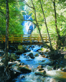
Photograph (item) - Colour photograph, Pre 2009
A colour photograph of the wooden bridge over the Steavenson River at the base of the Steavenson Falls in Marysville in Victoria.A colour photograph of the wooden bridge over the Steavenson River at the base of the Steavenson Falls in Marysville in Victoria. This bridge was destroyed in the 2009 Black Saturday bushfires. The Steavenson Falls are named after the Victorian Assistant Commissioner of Roads and Bridges, John Steavenson who arrived in Victoria in the early 1860s.steavenson river, steavenson falls, marysville, victoria, waterfalls, john steavenson, 2009 black saturday bushfires -
 Lakes Entrance Historical Society
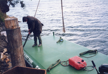
Photograph - Barges, Lakes Post Newspaper, 1999
Photo and article appeared in the Lakes Post Newspaper 28 July 1999|Barge was built by Wayne Smith for the firm East Gippsland Bridges.|Also two other photographs similarColour photograph of the launching of a new work barge in the Tambo River, Victoria.boats and boating, waterways, barges -
 Federation University Historical Collection
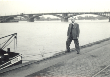
Photograph - Black and White, Frank Wright beside a river
Frank Wright was a renown resident of Smeaton, where he was born. He lived at Laura Villa, and attended Smeaton State School. His father William was a gold miner and his mother's name was Sarah. Their family won many singing and instrumental awards. Frank was tutored by Percy Code and was awarded a gold medal for the highest marks in the ALCM examinations in the British Colonies at the age of seventeen years. He became the Australian Open Cornet Champion by the age of eighteen. A year later, Frank conducted the City of Ballarat Band, and later the Ballarat Soldiers’ Memorial Band. He formed the Frank Wright Frisco Band and Frank Wright and his Coliseum Orchestra. These bands won many South Street awards, and Frank as conductor won many awards in the Australian Band Championship contest. In 1933 Frank Wright sailed to England to conduct the famous St Hilda’s Band and was later appointed Musical Director of the London County Council, where he organized many amazing concerts in parks, in and around the London district. He was made Professor of Brass and Military Band Scoring and conducted at the Guildhall of Music and Drama. Frank was often invited to adjudicate Brass Band Championships around Europe, in Australia, including South Street and in New Zealand. The Frank Wright Medal at the Royal South Street competition is awarded to an individual recognized as making an outstanding contribution to brass music in Australia.This is a black and white photograph of a man standing beside a river along side a boat which is tied to the wharf, the boat is called Reitz. Behind the man is a three spanned arched bridge. The man is Frank Wright.frank wright -
 Stawell Historical Society Inc
Photograph, Bush Sawmill beside the Wimmera River in Dunolly 1993
Dunolly 1993. Bush Sawmill beside the Wimmera River. Wooden buildings in Background. Chimney of what appears to be a steam driven engine with flywheel and belt driving a saw bench. Several men in photo. Original photographic taken by Charles Nettleton.Black & white photograph of timber and logs beside a water body with buildings and a tall chimney in the background. Around seven people in the background.Bush Saw Mill Wimmera River near Stawell 1877 Negative Reversed copy also 2641water industry -
 Phillip Island and District Historical Society Inc.
Photograph, First Phillip Island Bridge, Pre 1968
Original Phillip Island bridge which was replaced in 1968Large coloured photo of the first Phillip Island Bridge looking from Newhaven towards San Remo at low tide.Nilnewhaven, phillip island bridge, san remo -
 Stawell Historical Society Inc
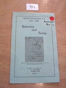
Book, N.A. McLennan, Yesterday and Today - Ord River Station WA 1895 - 1896 by N A McLennan, 1965
John McLennan's Period as Manager of the Ord River Station. W.A. adjoining Negri Station N.T., was 1895-6. The whole area consisted of 3,365,000 areas under a number of leasesand the then owner was Mr W.H. Osmand, who lived at "The Sycamores" four miles east of Stawell in Victoria. The Distance to Ord W.A. is 4,000 Miles.LIght green card cover with border, inside print and picture of a map Ord River Station W.A. 1895-1896 Yesterday and Today Map of North-East of W.A. Kimberly Ord River area Negri Station N.T. Complied and written by N.A. McLennan December 1965 1965 Victoriastawell, mclennan family -
 Peterborough History Group
Photograph - Photographs of The Bridge over The Curdies River
Historic views of the old wooden bridge, since replaced, and also showing the configuration of the river at that time.River and bridge integral part of Peterborough life. Digital image of two black and white photographs of the Bridge over the Curdies River, both taken from the East side showing different water levels in the rivercurdies river, curdies river bridge peterborough, peterborough victoria, great ocean road, curdies river estuary