Showing 11430 items
matching maps
-
 Bendigo Historical Society Inc.
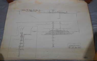
Administrative record - Central Red, White and Blue Mine map
Draftsman's drawing of Central Red, White and Blue Mine Map. Printed by Troedel & Cooper Pty Ltd. Mr. H. Cumby, Surveyor Forms part of the Margaret Roberts Collection of mining records.bendigo, margaret roberts, gold, map, mine, central red white & blue -
 Bendigo Historical Society Inc.
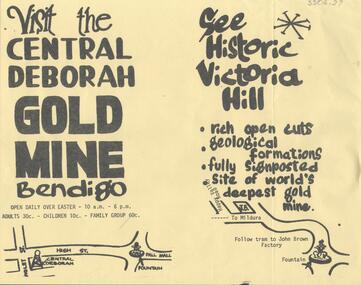
Document - CENTRAL DEBORAH GOLD MINE: ADVERTISING FLYER
BHS CollectionA4 advertising flyer,yellow background, black text. 'Visit the Central Deborah Gold Mine Bendigo' 'See Historic Victoria Hill'. Handrawn mud maps for each site on bottom of page.bendigo, mining, crentral deborah gold mine -
 Bendigo Historical Society Inc.
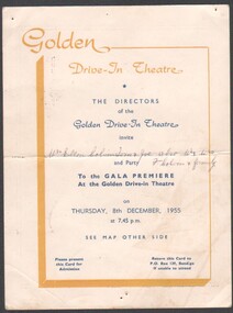
Programme - Bendigo Golden Drive-in Theatre Gala Premier
The Gala opening was held on 8/12/1955 and the Drive-in closed 3/2/1985. It was situated on the Western side of Crook Street and had one screen and the capacity for 700 cars. It was run by the Houlihan family.Invitation to the Gala Premier Opening of Bendigo's Golden Drive-in Theatre on Thursday 8th December 1955. Cream coloured card with yellow and blue printing. Reverse has a map showing the location of the Theatre.Invite has been offered to Mrs Ellen Colvin, Tom & Joe, also Mr & Mrs F. Colvin and familyinvitation, drive in theatre, golden drive-in theatre' -
 Warrnambool and District Historical Society Inc.
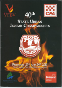
Booklet, CFA 40th Championship, 2003
The Warrnambool Fire Brigade was formed in 1863. The first fire engine house was in Liebig Street and carters were required to carry water to fire scenes. In 1889 the Council built a new Fire Station on Liebig Street and Warrnambool hosted its own Annual Demonstration in 1894. In 1891 the volunteer brigade became part of the Country Fire Brigade. The Fire Station relocated to Raglan Parade in 1915 and then to Timor Street in 1961. In 1989 the Brigade moved back to Raglan Parade. This booklet is a memento of the State Championships that were held in Warrnambool to mark 150 years of community service to Warrnambool by the Warrnambool Fire Brigade. (2013)This is a booklet of 63 pages containing printed material, maps, advertisements and photographs. The back cover is red and the front cover has a black background with an image of flames and a badge with the title of the booklet. The pages are stapled.Front Cover: VFBV, CFA, 40th State Urban Junior Championships, February 23rd and 24th 2013, Friendly Societies Park, Hyland Street, Warrnambool, Warrnambool City Council, Powercor Australia Back Cover: Powercor Australia warrnambool fire brigade, state urban junior championships -
 Ringwood and District Historical Society
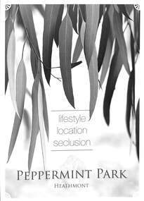
Flyer, Residential Land Sale Brochure, Peppermint Park, Heathmont, Vic. - 2010
Double-sided A3 size advertisement for Peppermint Park, Heathmont, Victoria, advertising sale of ten homesites with diagram showing locality map, size of blocks and layout of streets within and around the subdivision.Subdivision layout includes Pleasant Drive, Swain Court and Barbara Court off Culverlands Road and Armstrong Road in Heathmont. Agents - Carter Real Estate Agency, 90 Maroondah Highway, Ringwood Vic 3134 (Telephone) 98706211. Auctioneers - Richard Carter & William Lyall - 0411823337. Handwritten price list notations included, and Stage 2 Plan digitally signed by Michael Herwald Hipfel, Licensed Surveyor, 10/2/1916. -
 Lakes Entrance Historical Society
Book, Stone, John and Smith, Roger, East Gippsland Wilderness Walks. The Rodger-Bowen Walk, 1986
Guide to the 9 walks in the Rodger-Bowen wilderness, east of the Snowy River in far East Gippsland, Victoria. Includes a locality sketch map and sketches of leaves and fruit of eucalypts which may be encountered.natural history, vegetation, gippsland -
 Ringwood and District Historical Society
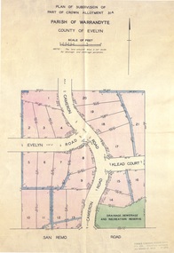
Document - Real Estate Folder, Savernake Estate, Ringwood, Victoria - Stage one - 1967
Plan of Subdivision, Part of Crown Allotment 31A and advertisement for sale of residential allotments with map showing layout of subdivision. Typewritten pricelist attached outlining suggested terms of sale as of 14 September, 1967.Subdivision includes Evelyn Road, Cameron Road, Klead Court, and San Remo Road. Agent - C.E. Carter & Son., 126 Whitehorse Road, Ringwood. (Phone) 87-6024, 87-6830, 870-2519, After hours: 723 3298, 878 2648. Subdivision Plan stamped Donald Cameron Consultants Pty. Ltd., Consulting Engineers, 472 Bourke Street Melbourne - 67-2602. -
 Bendigo Military Museum
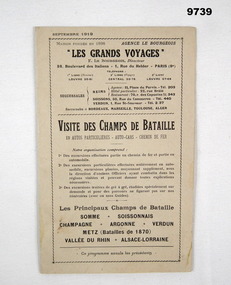
Pamphlet - FRENCH TOURISM, 1919, C.1919
Item in the collection relating to C.J.C. McQuie MM, refer Cat No 9680P for his service details.Pamphlet 16 pages, light brownish colour, all print in black, language is French, pages cover places to visit, advertising, maps and drawings, one metal staple holds all together."Les Grands Voyages"french, mcquie, pamphlet -
 Bendigo Historical Society Inc.
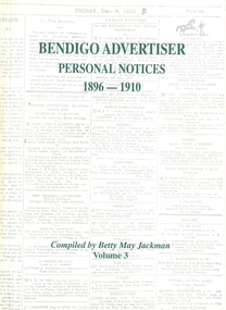
Book - BENDIGO ADVERTISER PERSONAL NOTICES 1896 - 1910, 1896-1910
Hardcover book with 504 pages of personal notices published in the Bendigo Advertiser 1896 - 1910 compiled by Betty May Jackman Volume 3 some black and white photographs & a map. Signed by Author.Betty May Jackmanbooks, catalogues, personal notices -
 Bendigo Military Museum
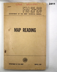
Manual - MAP READING, Department of Army, C. 1956
Soft cover, brown manual, Map Reading, RM21-26 Department of Army Technical Manual March 1956. 216 pages with fold out sections, photos, sketches, graphs & technical data.“12843 WILLIAMS”books - manuals, military, map reading -
 Bendigo Historical Society Inc.
Map - CAMPBELL COLLECTION: BENDIGO AND DISTRICT MAPS
Map. Forest Commission Victoria, Bendigo Forest District, Basic information prepared 1982, scale 1:100,000. Fire Prevention Strategy Plan. Mitiamo, Greater Bendigo Area, Castlemaine F.D.map, bendigo, forest district -
 4th/19th Prince of Wales's Light Horse Regiment Unit History Room
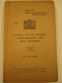
Book, Modern Printing Co Pty Ltd, Manual of Map Reading, Photo Reading and Field Sketching1929, abt 1929
Soft covered book covering map reading, field sketching and air photo reading for use of Officer candidates, Officers and NCO's. Reprinted with amendments Nos 1 - 4, 1939. 2 copies26 manuals 412manual, map reading, air photo reading, field sketching -
 4th/19th Prince of Wales's Light Horse Regiment Unit History Room
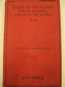
Book, Manual of Map Reading, Photo Reading and Field Sketching1929, abt 1940
Hard covered book covering map reading, field sketching and air photo reading for use of Officer candidates, Officers and Non-commissioned Officers. Reprinted with amdts Nos 1 - 4 193926 Manuals 412manual, map reading, air photo interpretation, field sketching -
 Ringwood and District Historical Society
Map, Plan of Subdivision - State School Estate, Ringwood East, Victoria - (Undated, circa 1920s)
Map of land for sale attached to green cardboard backing with handwritten notations showing numbered allotments on Dublin Road, Holland Road, King Street, Charles Street and Purser Avenue, Ringwood East.Locality plan includes reference to proposed Ringwood East railway station which opened in 1925. -
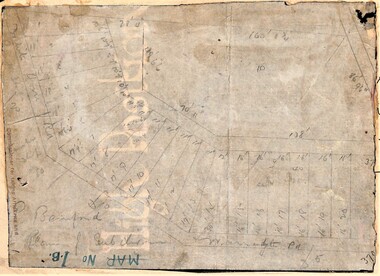 Ringwood and District Historical Society
Map, Planned subdivision on White Horse Road & Warrandyte Road corner, Ringwood, Victoria - (Undated - circa 1950s)
Faded hand-drawn map on lightly transparent paper with cardboard backing. Subdivision plan for Bamford's Timber site, later varied for Safeway supermarket and subsequently part of Eastland shopping precinct by 2020s.P. Bamford -
 Federation University Historical Collection
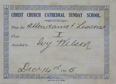
Books, Prize Books Awarded to Ivy Wilson, 1915-18
Three hard covered books which were awarded to Ivy Wilson as prizes. .1) Holiday Times .2) In the Master's Footsteps .3) The Prize for Girls and Boys Gift of Nola Jones, daughter of Ivy Wilson, 2016.1) Special Prize given by Miss Wilson to Ivy Wilson, G.F.S. Candidate, Christ Church Branch, 11.12.15 .3) Presented to Ivy Wilson for Best Maps Grade VIa S.S. No. 34 20/8/18christ church ballarat, girls' friendly society, ivy wilson, bookplate, christ church cathedral sunday school bookplate, christ church cathedral sunday school prize plate, prize plate, humffray street state school no. 34, books, christmas, fairies, school, education, teacher, student, father christmas, santa claus, christmas tree, premium plate -
 Rutherglen Historical Society
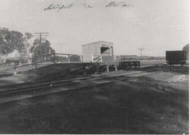
Image, Norman W. De Pomeroy, 1/07/1960
Black and white photograph of the Lilliput siding platform and stationWritten at top of photo: "Lilliput Railway Station: On back of photo: "Lilliput Siding - A solitary truck awaits loading. 1.7.1960" "Located at Map Ref 526 032" Rubber stamp: "Photographed by Norman W. De Pomeroy"railway stations, lilliput -
Ringwood and District Historical Society
Map, Ringwood Croydon Mail, Map of East Ringwood with numbered sites of interest published by the Ringwood Croydon Mail for Ringwood Secondary College Fire Appeal Fund. 1993, 16-Sep-93
Map of East Ringwood with numbered sites of interest published by the Ringwood Croydon Mail as the major sponsor for Ringwood Secondary College Fire Appeal Fund. The school was extensively burnt in a fire in 1992 which destroyed classrooms, records, musical and sports displays.White sheet of paper with brown printing, A3, with marked locations for visiting. -
 Greensborough Historical Society
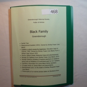
Folder, Black Family - Greensborough, 1900o
Contents: Family tree; small school books from family member; copy of map and advertisement for Watsonia Electric Station Estate; receipts; cemetery information; article on James Black and descendants; copies of un-named photos taken on Bundoora farm.The Black family owned a large portion of land from Greensborough to Watsonia. This collection is partly from family members.20-page plastic binder, green cover. Contains documents relating to the Black family of Greensborough and Watsonia.Collected by Greensborough Historical Society. Folder commenced 2012black family, shirley fraser, james black, watsonia electric station estate -
Tatura Irrigation & Wartime Camps Museum
Booklet, Hiking from the Australian Jamboree, 1935
Souvenir booklet printed for 1935 Frankston Jamboree. A hike to Gilwell Park, Gembrook. Booklet contains fold out maps of hiking areas. Also early aboriginal history of Victoria and in 1837, when John Gardiner occupied Mooroolbark sheep station.Small brown covered booklet, black writing. Sketch of Scout in hiking gear on front. Scout Emblem and kangaroo, Australian Jamboree, Frankston, Vic 1935 on back cover.scouting, books, history, local -
 Rutherglen Historical Society
Map, 1908
This is a map produced as part of a book entitled.. It is also stamped on the back in blue ink with an oval ring and the words North of England Institute. Newcastle. Mining & Meterolgical Faculty. Purchased on 23rd July 2017 by the Society after research by member Simon Killeen. Mining map of one of the first mines in Rutherglen area ( Chiltern West)Cream paper, black printing, rectangle with a drawingGeographical Survey of Victoria, Memoir, No6. Plate XX Plan of Underground Workings CHILTERN VALLEY CONSOLS MINE, RUTHERGLEN, PARISH OF CHILTERN WESTgold, rutherglen, mining, chiltern, underground mine map, geological survey, reef drives -
 Linton and District Historical Society Inc
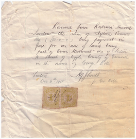
Receipt, Receipt for Payment for a Block of Land near Linton, 1918
Note that the block of land which was traded was not the block in Sussex Street, Linton on which the Sandows had a shop and house, but a block just outside the town boundary, near the Geelong Road (Linton-Naringhil Road). See map of Parish of Argyle for clarification.Photocopy of original handwritten receipt, which was for payment in full for a block of land situated just outside of Linton - Section A, Crown Allotment 1, Parish of Argyle. This land was purchased by Rubina (Ruby) Sandow from George Bolte in 1918. Receipt is for fifteen pounds, it is made out to "Rubinia Norwood Sandow" and is signed by Alf J. Smith, "for Geo. Bolte". Two Victorian Stamp Duty stamps are attached to the original document.rubina (ruby) sandow, george bolte, receipts, sale of land -
 Falls Creek Historical Society
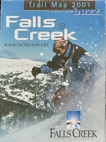
Booklet - Falls Creek Trail Guides 2001, 2003, 2005
These publications were developed by the Falls Creek Resort Management Committee to promote activities and facilities at Falls Creek for the Winter Seasons of 2001, 2003 and 2005. They include extensive information about ski trails, maps as well as ski and lift passes and packages.These items are important because they document seasonal activities at Falls Creek Alpine Resort over time.Three glossy coloured flyers featuring images and information about skiing and trails at Falls Creek. Prices for different lift passes, ski gear rental and season passes are included.falls creek marketing, lift passes, ski packages falls creek, falls creek trail maps -
 Bendigo Military Museum
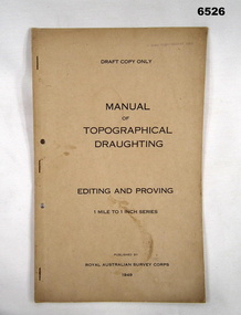
Document - Royal Australian Survey Corps - Manual of Topographical Draughting - Editing and Proving 1949, Royal Australian Survey Corps, 1949
This Draft document is part of the Topographical Drafting Manual produced by the Royal Australian Survey Corps in 1949. This document covers the guidelines for Editing and Proving (quality control) of the 1 Mile to 1 Inch map series that was widely produced by the Corps over Australia.A 10 x page foolscap sized buff coloured covered document, stapled and two hole punchedStamped on cover "E Comd Field Survey Unit"royal australian survey corps, rasvy, fortuna, army survey regiment, army svy regt, asr -
Hume City Civic Collection
Manual - Directory, SUNBURY/LOCAL INFORMATION/MANUAL 1983-84
This 1983-84 Sunbury local manual lists the names, addresses and telephone numbers of local residents and businesses as well as business advertisements. There is an index, a Useful Information page and a map with street index. It has a Shire of Bulla council service directory for Sunbury.A 90 Page local manual with a coloured photo of the Goonawarra Golf Club on the front cover.SUNBURY/LOCAL/INFORMATION/MANUAL 1983-84sunbury, directory, 1980s, residents, businesses., shire of bulla, civic, george evans collection -
 Bendigo Military Museum
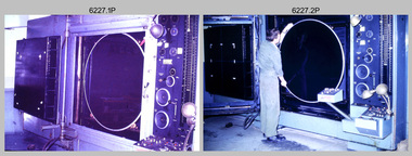
Photograph - Photographic Technicians operating the KLIMSCH Camera at the Army Survey Regiment, Fortuna, Bendigo, c1988
These nine photographs were most likely taken in c1988 in Lithographic Squadron at the Army Survey Regiment, Fortuna, Bendigo. The equipment operated by the technicians is the KLIMCH camera. The main tasks undertaken by the technicians were most likely enlargements and reductions of map reproduction material. The KLIMSCH Commodore camera was introduced in 1953 and was the largest in the Southern Hemisphere. It was replaced with a new model of the same size in 1979. The new model with its computer-based interface provided productivity gains with improved speed and its consistent results led to less wastage in time and materials. Its variomat lens system provided improved retention of map feature linear weights during the camera reduction process. The camera which was specially made for the Army in Germany was fully automatic and power operated. It was claimed to be one of the biggest automatic cameras of its type in the world. It was made to the specifications of the Royal Australian Army Survey Corps to assist in the production of the very high standard maps for the Army. There are several more photos catalogued in the Victorian Collections database of RA Svy personnel operating the KLIMSCH camera.This is a set of four photographs of technicians operating the KLIMSCH Camera at the Army Headquarters Survey Regiment, Bendigo c1988. The photographs are on 35mm colour slides scanned at 96 dpi. They are part of the Army Survey Regiment’s Collection. .1) - Photo, colour, c1988, KLIMSCH Camera. .2) - Photo, colour, c1988, KLIMSCH Camera, unidentified technician. .3) - Photo, colour, c1988, KLIMSCH Camera. .4) - Photo, colour, c1988, KLIMSCH Camera, L to R: SPR Shona Hastie, CPL Paul Baker. .5) - Photo, colour, c1988, KLIMSCH Camera. .6) & .7) - Photo, colour, c1988, KLIMSCH Camera, SPR Shona Hastie. .8) & .9) - Photo, colour, c1988, KLIMSCH Camera, SPR Russell Pajank.35mm colour slides are in good condition.rasvy, royal australian survey corps, army survey regiment, army svy regt, fortuna, asr, litho sqn -
 Bendigo Military Museum
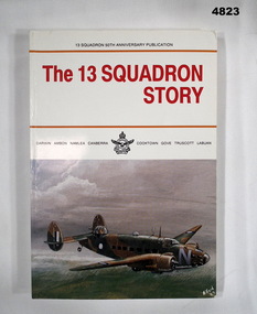
Book - BOOK, WW2 13 Squadron 50th Anniversary Publication, GRANTHAM Sid, "The 13 Squadron Story", 1991
13 Squadron 50th Anniversary Publication. Official and unofficial history of No.13 Squadron R.A.A.F. during its wartime existence from 1940 to 1946.Soft Cover book. Soft cover - cardboard, red and black colour print on front, spine and back. Front cover illustration, copy of oil painting (in colour) of "Lockheed Hudson" aircraft by artist ALFORD Robert. Back cover illustration in colour of the unofficial badge of No. 13 Squadron. 158 pages plus appendix, cut, plain white. Illustrated black and white photographs and maps. Front and back end papers illustrated black and white maps. Title page - signature by the author. 13 Squadron 50th Anniversary Publication. Official and unofficial history of No.13 Squadron R.A.A.F. during its wartime existence from 1940 to 1946.books, ww2, raaf, aircraft -
 Flagstaff Hill Maritime Museum and Village
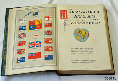
Book, Harmsworth Atlas and Gazetteer, 1908
This Harmsworth Atlas and Gazetteer was inherited by one of the donors, a gift from her father who was Tasmanian.Large hard covered book with maps, charts and tables. The cover is green linen with green leather, gilt trimmed corners and decorative spine, It includes 500 maps and diagrams in colour, with commercial statistics and gazetteer index of 105,000 names. Jan 1908. Also inserted between the pages of the book were 2 folded sheets of waxed paper, each with carefully placed flowers pressed between them; native orchids and wattle. Published at Carmelite House, Carmelite Road, London flagstaff hill, warrnambool, shipwrecked coast, flagstaff hill maritime museum, maritime museum, shipwreck coast, flagstaff hill maritime village, great ocean road, harmsworth atlas and gazetteer, atlas 1908, maps 1908, gazetteer 1908, book 1908, pressed australian native flowers, pressed wattle, pressed orchid -
 Federation University Historical Collection
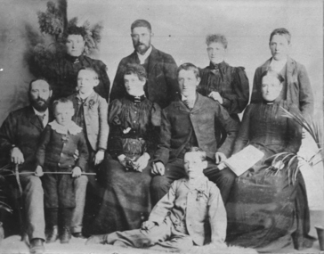
Photograph - Photograph and Documents, Anne Beggs Sunter, Latta/Downing Family, Mount Helen
The Federation University Mt Helen Campus was once the farm of John Latta and his wife Elizabeth Ann Dean. The couple married in 1867 and had three children at the time of John Latta's death (Elizabeth Ann b.1870; Mary b.1873; John b.1875). Elizabeth later married George Downing, and had another six children. The house was situated in the vicinity of the current Administration and Caro Conference Centre buildings, surrounded by an orchard, and a well under the current Albert Coates Building (Union Building). The land was purchased by the Ballarat School of Mines for their tertiary division from the Stapleton family.Various items relating to the Federation University Mount Helen Campus, and the early settlers on the land, the Latta Family. .1) Parish Plan, including E. Latta, M. Fiscalini, R. Wynne, R. Nixon, J.U. Smith, J. Davis .2) Part of a 1930s ordinance map showing Ballarat, Buninyong and Greenhill .3) Contour Map with the first two Mt Helen Campus buildings included. .4) Drawing a a proposed campus plan .5) Latta Family negativemount helen campus, latta family, greenhill, e. latta, m. fiscalini, r. wynne, r. nixon, j.u. smith, j. davis, parish plan, john latta, elizabeth latta, george downing, elezabeth downing, green hill, pontresina, abraham baxter, g. dean, market gardens, jim downing, bob thornton, j. hateley, martin fanning, toll keeper, anne beggs sunter -
 Federation University Historical Collection
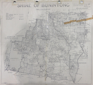
Map, Shire of Buninyong, c1970
The Shire of Buninyong was located on the southern side of Ballarat.Two maps of the Shire of Buninyong. .1) Map showing the County divisions, township boundaries, Railway line, State Forest boundary, riding boundary and shire boundary. Identifying words have been added in red and green texta. .2) Shire of Buninyong Parish Plan. Includes Buninyong, Clarendon, Narmbool, Enfield, Lychfield, SCotchman's, Navigators, Warrenheip, Scotsburn, mr Doran, Durham Lead, Cambrian Hill, Napoleons, Garibaldi, Mt Clear, Lal Lal, Bonshaw.1) B.I.A.E., St Martin's, cemetery, mt Buninyong, mt Innes, rly stn shire of buninyong, buninyong, clarendon, narmbool, enfield, lychfield, scotchman's, navigators, warrenheip, scotsburn, mt doran, durham lead, cambrian hill, napoleons, garibaldi, mt clear, lal lal, bonshaw, state forest, elaine, elaine north, cargerie, grenville, mt mercer, millbrook, wallace, yendon, canadian, kaolin deposits, mount helen campus