Showing 11430 items
matching maps
-
 Ringwood and District Historical Society
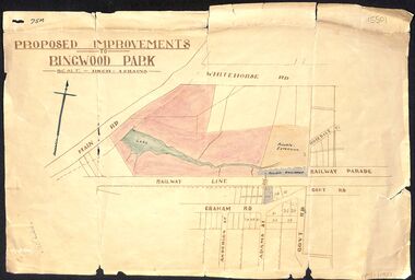
Map, Proposed Improvements to Ringwood Park (Ringwood Lake) dated 14 January 1927
Proposed Improvements to Ringwood Park (Ringwood Lake) dated 14 January 1927, signed Cr McCaskill. Main Road is Whitehorse Road (Maroondah Highway), and Mt Dandenong Road is incorrectly labelled Whitehorse Road. The map shows Rosedale Crescent and Railway Parade, both of which exist in 2024. On the bottom of the map, south of the railway line, showing proposed streets - Graham Road, Anderson Street and Adams Street - in preparation for the sale of the Theo Anderson property. That area is now Bedford Park. -
 Bendigo Historical Society Inc.
Map - CAMPBELL COLLECTION: BENDIGO AND DISTRICT MAPS
Map. Bendigo Whipstick Forest Park, 1:75,000, reserved forest and crown land, highway main road access forest tracks. New Moon Mine, Elliot Dam, Nuggety Dam, Rogers Tree, Old Tom Mine, Blow Holes, Skylark Dam, Monument Rock, Hartland Eucalyptus Still and Dam, Hartland Eucalyptus Farm, Millwood Dam, Sandner Eucalyptus Still Site, Various unmarked dams. (number 391 in map cupboard 1)map, bendigo, country lands -
Bendigo Historical Society Inc.
Map - CAMPBELL COLLECTION: BENDIGO AND DISTRICT MAPS, 8-7-29
Map. Rifle Range, Parishes of Wellsford and Sandhurst. Scale 20 chains to 1 inch. Total area by Planimeter 5916 acres. Wallan and Bendigo Railway line. Rifle Range. Axedale township and station 8 miles. To Longlea Ryl station 2 1/2 miles. To Epsom 1 1/2 miles. To Bendigo 3 miles. Compiled in W.P.D. from Assessment and Parish Plans by H.A.D 8-7- 29 (number 367 in map cupboard 1)H.A.D.(H.A.Darby)map, bendigo, allotments -
Bendigo Historical Society Inc.
Map - REDESDALE : COUNTY OF BENDIGO, 25 -10-77
Map. Redesdale, County of Bendigo, County of Dalhousie, County Of Talbot, Lyell, Kimbolton, Langwornor, Spring Plains, Glenhope, Emberton, Metcalfe, Hawkestone, River Coliban, Campaspe River, Back Creek. Photo-Lithographed at the Department of Lands and Survey, Melbourne by J. Noune, 25-10-77. Compared with original plans 12-11-78 M. Kemp. J.C.Kelsh, Draughtsman April 1876. Examined by E. Downward, 5-6-77. (number 121 in map cupboard 1)J. Nounemap, bendigo, redesdale -
Bendigo Historical Society Inc.
Map - TARNAGULLA : COUNTY OF BENDIGO, 13-5-22
Map. County of Bendigo, County of Gladstone.Inglewood, Glenalbyn, Kingower, Moliagul, Waanyarra, Laaneoorie, Woodstock, Loddon River, Township of Tarnagulla, Township of Newbridge, Township of Llanelly, Dunolly to Inglewood Railway, Tarnagulla Rifle Range, Laurie Station, Bullabul Creek, Arnold Township, Arnold Railway Station. Photo-Lithographed at the Department of Lands and Survey, Melbourne by W.J. Butson, 13-5-22.Price 1/-.By authority A.J. Mullett, Government Printer, Melbourne. (number 118 in map cupboard 1)A.J. Mullett, Government Printer, Melbourne.map, bendigo, tarnagulla -
Bendigo Historical Society Inc.
Map - TARNAGULLA : COUNTY OF BENDIGO, 1959
Map. Tarnagulla, County of Bendigo, County of Gladstone, Inglewood, Glenalbyn, Kingower, Moliagul, Painswick, Waanyarra, Laanecoorie, Woodstock, Derby, Loddon River, Dunolly to Inglewood Railway, Laurie Railway Station, Township of Tarnagulla, Tarnagulla Rifle Range, Township of Llanelly, Arnold Railway Station, Bullabul Creek, Kangderaar Creek, Township of Newbridge. By authority A.C. Brooks, Government Printer, Melbourne. Drawn and reproduced at the Department of Lands and Survey, Melbourne, 1959. (number 117 in map cupboard 1)A.C. Brooks, Government Printer, Melbourne.map, bendigo, tarnagulla -
Bendigo Historical Society Inc.
Map - KNOWSLEY : COUNTY OF BENDIGO, 7-11-1941
Map. Knowsley, County of Bendigo, County of Rodney, Weston, Axedale, Eppalock, Knowsley East, Langwornor, Heathcote, Campaspe River, Mt. Ida Creek or Wild Duck Creek, Sandhurst and Heathcote Railway, Kilmore-Heathcote-Bendigo Road. Knowsley Station Ground. Shingle Hut Creek, Forest Creek. By authority H.E. Daw, Government Printer, Melbourne. Drawn and reproduced at the Department of Lands and Survey, Melbourne. 7-11-1941. Price 2/-. (number 103 in map cupboard 1)H.E. Daw, Government Printer, Melbourne.map, bendigo, knowsley -
Bendigo Historical Society Inc.
Map - HARCOURT : COUNTY OF BENDIGO, 23-3-10
Map. County of Bendigo, County of Talbot, Sutton Grange, Ravenswood, Walmer, Faraday, Castlemaine, Axe Creek, Barkers Creek, Melbourne to Echuca Railway, Victorian Water Supply in Connection with Barkers Creek Reservoir. Victorian Water Supply Reserve, Mt. Alexander State Forest. Three areas reserved for Sericulture (Silkworms). Photo-Lithographed at the Dept. of Lands and Survey, Melbourne by T.F. McGauran 23-3-10. Price 1/-. (number 101 in map cupboard 1)T.F. McGauranmap, bendigo, harcourt -
Bendigo Historical Society Inc.
Map - HEATHCOTE : COUNTY OF BENDIGO
Map. Heathcote, County of Bendigo, County of Dalhousie, Knowsley, Knowsley East, Dargile, Costerfield, Warrowitue, Tooborac, Langwornor, Argyle Station Ground, Bendigo to Heathcote to Kilmore Railway Line, Township of Heathcote, C.R.B. Main Road. Mount Ida Creek, Wild Duck Creek, Meadow Valley Creek. By Authority H.J. Green, Govt. Printer, Photo-Lithographed at the Department of Lands and Survey, Melbourne by W.J. Butson, Price 1/-. (number 91 in map cupboard 1)H.J. Green Govt. Printer.map, bendigo, heathcote -
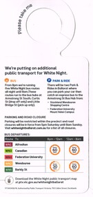 Ballarat Tramway Museum
Pamphlet, Public Transport Corporation (PTC), "White Night Ballarat", Feb. 2017
Set of two pamphlets distributed at the time for the "White Night Ballarat" Festival Saturday 4 March 2017. .1 - a grab rail pamphlet listing the bus services for the festival - piece of heavy card with a round top and a slit to enable it to be placed on a grab rail within the bus itself. .2 - 4 fold - DL sheet - titled "Give me the night" for the "White Night Ballarat" festival, with an map of the various events, messages of support, transport map and road closures. Published by Visit Victoria.trams, tramways, ballarat public transport, buses, ptv, public transport victoria, timetables, white night -
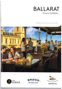 Ballarat Tramway Museum
Book, The Ballarat Visitor Information Centre, "Ballarat Victoria's goldfields Official Visitor Guide", 2015
Full colour, 84 page, book, A5 size titled "Ballarat Victoria's goldfields Official Visitor Guide", with a photo of a people eating on the verandah of the hotel opposite the old post office. Gives details, maps accommodation listing, attractions etc of the Ballarat area. Page 14 detail the Ballarat Tramway Museum. Inside rear cover is a fold out map of the district, city centre, Buninyong and Mt Helen and Ballarat and Surrounds. Published 2015 by The Ballarat Visitor Information Centre. trams, tramways, ballarat, visitors, tourist guides, btm, gardens -
 Bendigo Historical Society Inc.
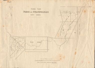
Document - MARKS COLLECTION: MAP OF PARISH OF STRATHFIELDSAYE 1858, 8th September, 1858
Buff coloured document. On top 'Country Lands, Parish of Strathfieldsaye, County Unnamed'. On bottom 'Scale 40 chains to an inch. Public Lands Office, Melbourne Sept 8th. 1858. William Collis, Lith ( lithographer )'. Map shows Village Reserve on Emu Creek, road from Sandhurst, Sheepwash Creek and Splitters Creek. Wellington Hotel marked on map near intersection of Sheepwash Creek, Axe Creek and Emu Creek. Axe Creek Pound near Splitters Creek.map, bendigo, parish of strathfieldsaye 1858 -
 Bendigo Historical Society Inc.
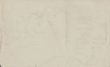
Document - PETER ELLIS COLLECTION: SKETCH OF THE BARFOLD GORGE
Two hand sketched maps on same sheet of paper, one of the location of the Barfold Gorge in relation to surrounding towns, Mt Alexander and Turpin;s Falls. The second map is a part of the Campaspe River location of the Barfold Gorge. Shown is the location of columns, pools, type of rock, Mitchell's Falls, tunnel, cave, Queen's Falls, house, windmill, fences and places where access to the bottom of the gorge is possible. Car track and scale of 1 mile = 6 inches are also shown.place, land, barfold gorge, peter ellis collection, mitchell's falls, queen's falls, turpin's falls -
 City of Greater Bendigo - Civic Collection
Administrative record - Land Sales, A. J. Mullet Government Printer et al, 1927
This type of album was made by agents auctioning and selling land.Large portfolio style album with dark green / black cloth cover bound with three large metal pins. Forty eight pages with twenty seven Department of Lands and Survey maps and newspaper clippings about land sales and auction details pasted in. Index page. Maps have handwritten notes and markings throughout in pencil and pen. Covers the County's of Gunbower and Tatchera. Includes a receipt slip with hand written notes on reverse on William Wallace & Co letterhead. city of bendigo commerce -
 Melbourne Tram Museum
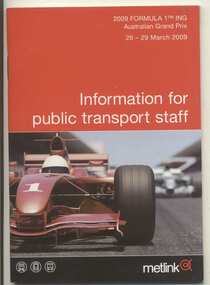
Book, Metlink, "Information for public transport staff - 2009 Formula 1 Australian Grand Prix", 2008
Forty page full colour publication plus covers with fold out map on the rear cover titled "Information for public transport staff - 2008 Formula 1 Australian Grand Prix". Gives details of event for train, tram and bus crews, event program and transport map, including shunting details, announcements, bus replacement services, electric or automatic points, route alterations. On the back cover has contact telephone numbers and web addresses. 2 copies held.trams, tramways, grand prix, metlink, formula 1, albert park -
 Melbourne Tram Museum
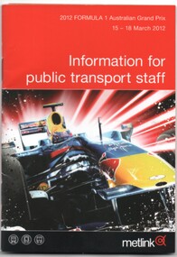
Book, Metlink, "Information for public transport staff - 2012 Formula 1 Australian Grand Prix", Feb. 2012
Book - 36 pages page full colour publication plus covers with fold out map on the rear cover titled "Information for public transport staff - 2012 Formula 1 Australian Grand Prix". Gives details of event for train, tram and bus crews, event program and transport map, including shunting details, announcements, bus replacement services, electric or automatic points, route alterations. On the back cover has contact telephone numbers and web addresses.trams, tramways, grand prix, metlink, formula 1, albert park -
 Melbourne Tram Museum
Book, Metlink, "Information for public transport staff - 2009 Formula 1 Australian Grand Prix", Feb. 2009
Forty page full colour publication plus covers with fold out map on the rear cover titled "Information for public transport staff - 2009 Formula 1 Australian Grand Prix". Gives details of event for train, tram and bus crews, event program and transport map, including shunting details, announcements, bus replacement services, electric or automatic points, route alterations. On the back cover has contact telephone numbers and web addresses. 2 copies held.trams, tramways, grand prix, metlink, formula 1, albert park -
 Melbourne Tram Museum
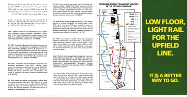
Pamphlet, The Met, "Low Floor light rail for the Upfield line - it is a better way to go", c1989
Pamphlet - four fold DL size full colour titled "Low Floor light rail for the Upfield line - it is a better way to go", explaining or providing advice on the proposal for the conversion of the Upfield line to Light rail and timing. Has a map of the proposal - has a translation in 11 languages. Includes a map showing the proposals, project details, why, level crossings, rail services and timing and proposals for a shuttle along Sydney Road. Second copy added 17-7-2017.trams, tramways, light rail, upfield light rail, conversion, sydney rd -
 Melbourne Tram Museum
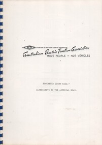
Document - Report, Australian Electric Traction Association (AETA), "Doncaster Light Rail - Alternative to the Arterial Road" - AETA, Feb. 1990
Report - 15 A4 pages - clear plastic covers, card rear cover, blue comb bound, titled "Doncaster Light Rail - Alternative to the Arterial Road" - AETA, containing their submission, drawings, map and images of light rail in Los Angeles and San Hose. Letter to addressed to Brandon Mack of the Ministry of Transport, 26/2/1990 part of the Eastern Arterial Extension and Ringwood By-Pass Review. Signed by H. Ballment. Report does not include the Appended photos, maps and drawings.trams, tramways, doncaster, aeta, conversion, light rail -
 Melbourne Tram Museum
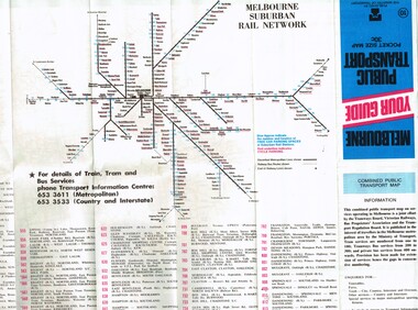
Map, Ministry of Transport, "Melbourne Your guide public transport", 1980
Fold out map (27 sections 9 across x 3 deep), coloured of Melbourne's Tram and Bus routes, route numbers, rail lines, detailed for the central part of Melbourne and insert section for Frankston. On rear description of routes, private bus routes and map of Melbourne metro lines. Has contact details for bookings and lost property etc. Priced 30c No. 11 Dated 1980 on rear .1 - 1 as above, blue cover, No. 10, also dated 1980.trams, tramways, melbourne, map, tram & bus services, railways, mmtb, minister for transport -
 Melbourne Tram Museum
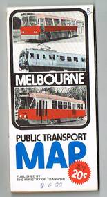
Map, Ministry of Transport, "Melbourne Transport Services Map - Tram, Train and Bus Services", 1976
Fold out map (27 sections 9 across x 3 deep), coloured of Melbourne's Tram and Bus routes, route numbers, rail lines, detailed for the central part of Melbourne and insert section for Frankston. On rear description of routes, private bus routes and map of Melbourne metro lines. Has contact details for bookings and lost property etc. Priced 20c Has a bus, silver train and a Z class tram on the cover. On bottom of outside cover, "No. 5 1976"On front cover in ink "5" in top right hand corner and "4 G 33 " along bottom edge.trams, tramways, melbourne, map, tram & bus services, railways, mmtb, minister for transport -
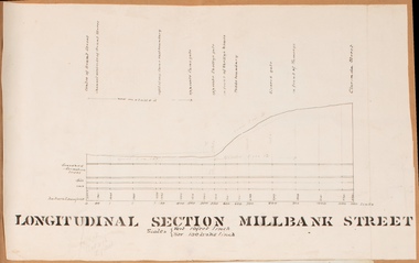 Bacchus Marsh & District Historical Society
Drawing, Longitudinal Section Millbank Street Bacchus Marsh circa 1905
Millbank Street is a short street located close to the central business and shopping area of Bacchus Marsh. In the early 1900s works to improve the drainage of the street were discussed and planned by Bacchus Marsh Shire Council. This plan is most probably the plan discussed at a Shire Council meeting in April 1905. Single page plan showing a longitudinal section view of MIllbank Street running from Clarinda Street to Grant Street in Bacchus Marsh. The names of Millbank Street property owners, Cain, Shelley, Oliver and Ramsay are marked on this plan. Scale: Vertical 10 feet to 1 inch. Horizontal: 100 links to 1 inch Part of a set of maps which are pasted into a bound volume containing 76 maps or plans in total. High resolution digital image stored on BMDHS computer network. bacchus marsh victoria maps, millbank street bacchus marsh -
Port Melbourne Historical & Preservation Society
Book - Reference, Gary Presland, Records of the Victorian Archeological Survey, 1977 - 1983
Purchased from Information Victoria, circa 2000Victorian Archeological Survey books by Gary Presland (editor or author). .01 - No5, 1977. Journals of George Augustus Robinson Jan -March 1840 (light orange cover 96 pages plus fold out route map) .02 - No 6 1977. Journals of George Augustus Robinson March - May 1841 (orange cover 102 pages plus fold out route map and illustrations) .03 - An archeological survey of the Melbourne Metropolitan area 1983 (yellow cover 136 pages)australian aborigines, natural environment, gary presland, george augustus robinson, archeology -
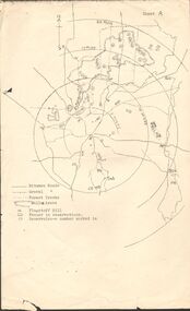 Bendigo Historical Society Inc.
Map - PETER ELLIS COLLECTION: MAP OF WHIPSTICK
Two maps of the Whipstick - Sheet A and Sheet B. Sheet A shows the Whipstick in relation to Bendigo and some surrounding places. Bitumen roads, gravel, forest tracks, Mallee Areas, Flagstaff Hill, fenced in reservations and reservoirs are marked. Also, a circle and part circles of 5-, 10-, 15- and 20-mile radius is marked. North & South are marked. Sheet B is an enlarged area of the Whipstick Scrub area. North and South is marked. There are a number of letters written over both maps.map, bendigo, peter ellis collection, the whipstick, flagstaff hill -
 Kiewa Valley Historical Society
Maps - Tawonga and Feathertop
Plan of Tawonga showing roads etc, rivers, use of land in 1968 and of Feathertop in 1969.Historical use of land in Tawonga and Feathertop.1. Topographical Map - Tawonga 803 Forests Commission of Victoria 1968. Cream paper with black print. Legend: Roads, tracks etc, rivers, Parishes and use of land. 2. Feathertop 813. 1969tawonga map 1968, tawonga parishes, feathertop map 1969 -
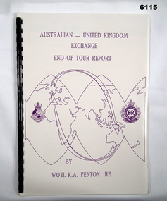 Bendigo Military Museum
Administrative record - Australian - United Kingdom Exchange End of Tour Report by WO2 KA Fenton RE 1990, WO2 KA Fenton RE, 25.10.1990
A 2 x year personnel exchange program existed between RASvy and the Survey elements of the Royal Engineers UK. This is an end of Tour Report produced by WO2 KA Fenton RE of his experiences during his exchange tour. An A4 Booklet stylised map of the world with Corps Badges foe RASvy and Royal Engineers (UK), back cover overhead aerial Photo of Army Svy Regt, 14 Pages, 4 Annexes and an enclosureroyal australian survey corps, rasvy, fortuna, army survey regiment, army svy regt, asr -
 Bendigo Military Museum
Administrative record - RASvy - Defense Mapping Agency Exchange Officer End of Tour Report MAJ D Bowen 1982, MAJ DH Bowen US Army Corps of Engineers, 3. 5. 1982
A 2 x year personnel exchange program existed between RASvy and the US Army Corps of Engineers. This is the End of Tour Report produced by David H Bowen, Major, Corps of Engineers, US Army Exchange Officer, Australia in 1982A4 Document, Plastic cover, Purple and gold, RASvy Badge emblem and Defense Mapping Agency Badge emblems in gold, 17 pages, 13 enclosures, black and white print, colour photos and mapsReport compiled by David H Bowen, Major, Corps of Engineers, US Army Exchange Officer, Australiaroyal australian survey corps, rasvy, fortuna, army survey regiment, army svy regt, asr -
 Bendigo Military Museum
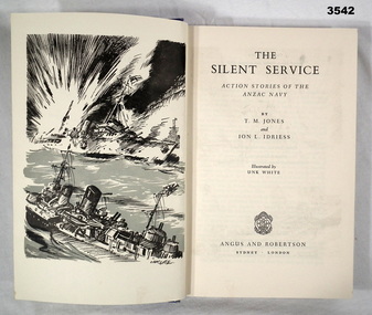
Book - BOOK, RAN, Halstead Press Pty Limited, The Silent Service, 1952 - Second Edition
The Silent Service - Action Stories of the ANZAC NavyHard, cardboard cover, blue buckram with silver print on spine. 372 pages, cut, plain, white. Illustrated in black / white / blue maps, end papers & back flyleaf. Page/s removed. Handwritten in black ink on title page: “Donated by Joy Wellings Re Stephen Langdon” Black felt tipped pen mark: “On front end paper” “RSL stamp”book, anzac navy, silent service -
 Bendigo Military Museum
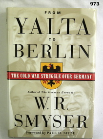
Book, From Yalta to Berlin. The Cold War Struggle over Germany, 1999
Hard cover, plain light grey, title in gold on spine, dust jacket illustration of seaman. Emblem (black eagle on yellow shield, subtitle in white on red. 465 pages some with photos and maps. Hand written on fly leaf "Donated by Bgo "y" mens club". books-military-history, cold war -
 Flagstaff Hill Maritime Museum and Village
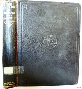
Book, The Outline of History Vol 1
This item is from the ‘Pattison Collection’, a collection of books and records that was originally owned by the Warrnambool Mechanics’ Institute, which was founded in Warrnambool in 1853. By 1886 the Warrnambool Mechanics’ Institute (WMI) had grown to have a Library, Museum and Fine Arts Gallery, with a collection of “… choice productions of art, and valuable specimens in almost every branch and many wonderful national curiosities are now to be seen there, including historic relics of the town and district.” It later included a School of Design. Although it was very well patronised, the lack of financial support led the WMI in 1911 to ask the City Council to take it over. In 1935 Ralph Pattison was appointed as City Librarian to establish and organise the Warrnambool Library as it was then called. When the WMI building was pulled down in 1963 a new civic building was erected on the site and the new Warrnambool Library, on behalf of the City Council, took over all the holdings of the WMI. At this time some of the items were separated and identified as the ‘Pattison Collection’, named after Ralph Pattison. Eventually the components of the WMI were distributed from the Warrnambool Library to various places, including the Art Gallery, Historical Society and Flagstaff Hill. Later some were even distributed to other regional branches of Corangamite Regional Library and passed to and fro. It is difficult now to trace just where all of the items have ended up. The books at Flagstaff Hill Maritime Village generally display stamps and markings from Pattison as well as a variety of other institutions including the Mechanics’ Institute itself. RALPH ERIC PATTISON Ralph Eric Pattison was born in Rockhampton, Queensland, in 1891. He married Maude Swan from Warrnambool in 1920 and they set up home in Warrnambool. In 1935 Pattison accepted a position as City Librarian for the Warrnambool City Council. His huge challenge was to make a functional library within two rooms of the Mechanics’ Institute. He tirelessly cleaned, cleared and sorted a disarrayed collection of old books, jars of preserved specimens and other items reserved for exhibition in the city’s museum. He developed and updated the library with a wide variety of books for all tastes, including reference books for students; a difficult task to fulfil during the years following the Depression. He converted all of the lower area of the building into a library, reference room and reading room for members and the public. The books were sorted and stored using a cataloguing and card index system that he had developed himself. He also prepared the upper floor of the building and established the Art Gallery and later the Museum, a place to exhibit the many old relics that had been stored for years for this purpose. One of the treasures he found was a beautiful ancient clock, which he repaired, restored and enjoyed using in his office during the years of his service there. Ralph Pattison was described as “a meticulous gentleman whose punctuality, floorless courtesy and distinctive neat dress were hallmarks of his character, and ‘his’ clock controlled his daily routine, and his opening and closing of the library’s large heavy doors to the minute.” Pattison took leave during 1942 to 1945 to serve in the Royal Australian Navy, Volunteer Reserve as Lieutenant. A few years later he converted one of the Museum’s rooms into a Children’s Library, stocking it with suitable books for the younger generation. This was an instant success. In the 1950’s he had the honour of being appointed to the Victorian Library Board and received more inspiration from the monthly conferences in Melbourne. He was sadly retired in 1959 after over 23 years of service, due to the fact that he had gone over the working age of council officers. However he continued to take a very keen interest in the continual development of the Library until his death in 1969. The Pattison Collection, along with other items at Flagstaff Hill Maritime Village, was originally part of the Warrnambool Mechanics' Institute’s collection. The Warrnambool Mechanics’ Institute Collection is primarily significant in its totality, rather than for the individual objects it contains. Its contents are highly representative of the development of Mechanics' Institute libraries across Australia, particularly Victoria. A diversity of publications and themes has been amassed, and these provide clues to our understanding of the nature of and changes in the reading habits of Victorians from the 1850s to the middle of the 20th century. The collection also highlights the Warrnambool community’s commitment to the Mechanics’ Institute, reading, literacy and learning in the regions, and proves that access to knowledge was not impeded by distance. These items help to provide a more complete picture of our community’s ideals and aspirations. The Warrnambool Mechanics Institute book collection has historical and social significance for its strong association with the Mechanics Institute movement and the important role it played in the intellectual, cultural and social development of people throughout the latter part of the nineteenth century and the early twentieth century. The collection of books is a rare example of an early lending library and its significance is enhanced by the survival of an original collection of many volumes. The Warrnambool Mechanics' Institute’s publication collection is of both local and state significance. The Outline of History Vol 1 Being a Plain History of Life and Mankind with maps & Plans by J. F. Horrabin Author: H G Wells Publisher: Waverley Book Co Ltd Date: 1925Label on spine cover with typed text PAT F 909 WEL Pastedown front endpaper has sticker from Warrnambool Public Library covered by a sticker from Corangamite Regional Library Service Front loose endpaper has a stamp from Corangamite Regional Library Service Fly paper has a stamp from Corangamite Regional Library Servicewarrnambool, shipwrecked-coast, flagstaff-hill, flagstaff-hill-maritime-museum, maritime-museum, shipwreck-coast, flagstaff-hill-maritime-village, shipwrecked-artefact, book, pattison collection, warrnambool library, warrnambool mechanics’ institute, ralph eric pattison, corangamite regional library service, warrnambool city librarian, mechanics’ institute library, victorian library board, warrnambool books and records, warrnambool children’s library, great ocean road, h g wells, the outline of history vol 1