Showing 13832 items matching "tasmanian-built"
-
![Photograph - Construction of the F19 [Eastern Freeway], Ron Setford, October 1976](/media/collectors/550653872162f11fb04854aa/items/682afcd6b92b884efed2688f/item-media/682aff26b92b884efed26ad9/item-fit-380x285.jpg) Kew Historical Society Inc
Kew Historical Society IncPhotograph - Construction of the F19 [Eastern Freeway], Ron Setford, October 1976
Ron Setford and his wife Grace Setford lived in Tanner Avenue, East Kew, from c.1946 to c.1995. A keen photographer, he recorded the changing face of Kew over a 20 year period. Apart from 30 photographs of built structures and places in Kew dating from 1960 and 1961, 145 of his 35mm colour slides chronicle the development of the F19 (later renamed Eastern) Freeway through the Yarra Valley in Kew over a five year period from c.1972 to c.1977. This important collection was donated to the Society by his granddaughter in 2025.This collection of 175 35mm slides is of local and statewide significance, owing to its subject matter, particularly the major development of road transport infrastructure during the 1970s with the construction of the Eastern Freeway. The photographer also took care to annotate and date most of his slides which enable the researcher to pinpoint temporal and spatial locations."Pylons are modelled / F/way bridge over Yarra"ron setford, eastern freeway, f19 freeway -
![Photograph - Construction of the F19 [Eastern Freeway], Ron Setford, October 1976](/media/collectors/550653872162f11fb04854aa/items/682affa8b92b884efed26f45/item-media/682b000ab92b884efed26fb0/item-fit-380x285.jpg) Kew Historical Society Inc
Kew Historical Society IncPhotograph - Construction of the F19 [Eastern Freeway], Ron Setford, October 1976
Ron Setford and his wife Grace Setford lived in Tanner Avenue, East Kew, from c.1946 to c.1995. A keen photographer, he recorded the changing face of Kew over a 20 year period. Apart from 30 photographs of built structures and places in Kew dating from 1960 and 1961, 145 of his 35mm colour slides chronicle the development of the F19 (later renamed Eastern) Freeway through the Yarra Valley in Kew over a five year period from c.1972 to c.1977. This important collection was donated to the Society by his granddaughter in 2025.This collection of 175 35mm slides is of local and statewide significance, owing to its subject matter, particularly the major development of road transport infrastructure during the 1970s with the construction of the Eastern Freeway. The photographer also took care to annotate and date most of his slides which enable the researcher to pinpoint temporal and spatial locations."New Chandler H/way bdge over f/way"ron setford, eastern freeway, f19 freeway -
![Photograph - Construction of the F19 [Eastern Freeway], Ron Setford, October 1976](/media/collectors/550653872162f11fb04854aa/items/682885af64071e7c58e69a72/item-media/682885d464071e7c58e69c9c/item-fit-380x285.jpg) Kew Historical Society Inc
Kew Historical Society IncPhotograph - Construction of the F19 [Eastern Freeway], Ron Setford, October 1976
Ron Setford and his wife Grace Setford lived in Tanner Avenue, East Kew, from c.1946 to c.1995. A keen photographer, he recorded the changing face of Kew over a 20 year period. Apart from 30 photographs of built structures and places in Kew dating from 1960 and 1961, 145 of his 35mm colour slides chronicle the development of the F19 (later renamed Eastern) Freeway through the Yarra Valley in Kew over a five year period from c.1972 to c.1977. This important collection was donated to the Society by his granddaughter in 2025.This collection of 175 35mm slides is of local and statewide significance, owing to its subject matter, particularly the major development of road transport infrastructure during the 1970s with the construction of the Eastern Freeway. The photographer also took care to annotate and date most of his slides which enable the researcher to pinpoint temporal and spatial locations."Light Standard Mounts / 10/75"ron setford, eastern freeway, f19 freeway -
![Photograph - Construction of the F19 [Eastern Freeway], Ron Setford, October 1976](/media/collectors/550653872162f11fb04854aa/items/682b01eeb92b884efed2793a/item-media/682b0333b92b884efed27cfc/item-fit-380x285.jpg) Kew Historical Society Inc
Kew Historical Society IncPhotograph - Construction of the F19 [Eastern Freeway], Ron Setford, October 1976
Ron Setford and his wife Grace Setford lived in Tanner Avenue, East Kew, from c.1946 to c.1995. A keen photographer, he recorded the changing face of Kew over a 20 year period. Apart from 30 photographs of built structures and places in Kew dating from 1960 and 1961, 145 of his 35mm colour slides chronicle the development of the F19 (later renamed Eastern) Freeway through the Yarra Valley in Kew over a five year period from c.1972 to c.1977. This important collection was donated to the Society by his granddaughter in 2025.This collection of 175 35mm slides is of local and statewide significance, owing to its subject matter, particularly the major development of road transport infrastructure during the 1970s with the construction of the Eastern Freeway. The photographer also took care to annotate and date most of his slides which enable the researcher to pinpoint temporal and spatial locations."New Chandler H/way bridge over f/way"ron setford, eastern freeway, f19 freeway -
![Photograph - Construction of the F19 [Eastern Freeway], Ron Setford, October 1976](/media/collectors/550653872162f11fb04854aa/items/682b0049b92b884efed27059/item-media/682b01a4b92b884efed277b0/item-fit-380x285.jpg) Kew Historical Society Inc
Kew Historical Society IncPhotograph - Construction of the F19 [Eastern Freeway], Ron Setford, October 1976
Ron Setford and his wife Grace Setford lived in Tanner Avenue, East Kew, from c.1946 to c.1995. A keen photographer, he recorded the changing face of Kew over a 20 year period. Apart from 30 photographs of built structures and places in Kew dating from 1960 and 1961, 145 of his 35mm colour slides chronicle the development of the F19 (later renamed Eastern) Freeway through the Yarra Valley in Kew over a five year period from c.1972 to c.1977. This important collection was donated to the Society by his granddaughter in 2025.This collection of 175 35mm slides is of local and statewide significance, owing to its subject matter, particularly the major development of road transport infrastructure during the 1970s with the construction of the Eastern Freeway. The photographer also took care to annotate and date most of his slides which enable the researcher to pinpoint temporal and spatial locations."New Chandler H/way bridge"ron setford, eastern freeway, f19 freeway -
![Photograph - Construction of the F19 [Eastern Freeway], Ron Setford, February 1975](/media/collectors/550653872162f11fb04854aa/items/682c45685014d0f6bed696b2/item-media/682c45895014d0f6bed69718/item-fit-380x285.jpg) Kew Historical Society Inc
Kew Historical Society IncPhotograph - Construction of the F19 [Eastern Freeway], Ron Setford, February 1975
Ron Setford and his wife Grace Setford lived in Tanner Avenue, East Kew, from c.1946 to c.1995. A keen photographer, he recorded the changing face of Kew over a 20 year period. Apart from 30 photographs of built structures and places in Kew dating from 1960 and 1961, 145 of his 35mm colour slides chronicle the development of the F19 (later renamed Eastern) Freeway through the Yarra Valley in Kew over a five year period from c.1972 to c.1977. This important collection was donated to the Society by his granddaughter in 2025.This collection of 175 35mm slides is of local and statewide significance, owing to its subject matter, particularly the major development of road transport infrastructure during the 1970s with the construction of the Eastern Freeway. The photographer also took care to annotate and date most of his slides which enable the researcher to pinpoint temporal and spatial locations.Chemically altered 35mm slide"Belford Bridge / Feb 75 / Freeway roadlaying"ron setford, eastern freeway, f19 freeway -
![Photograph - Construction of the F19 [Eastern Freeway], Ron Setford, February 1975](/media/collectors/550653872162f11fb04854aa/items/682c460f5014d0f6bed69889/item-media/682c46335014d0f6bed69a13/item-fit-380x285.jpg) Kew Historical Society Inc
Kew Historical Society IncPhotograph - Construction of the F19 [Eastern Freeway], Ron Setford, February 1975
Ron Setford and his wife Grace Setford lived in Tanner Avenue, East Kew, from c.1946 to c.1995. A keen photographer, he recorded the changing face of Kew over a 20 year period. Apart from 30 photographs of built structures and places in Kew dating from 1960 and 1961, 145 of his 35mm colour slides chronicle the development of the F19 (later renamed Eastern) Freeway through the Yarra Valley in Kew over a five year period from c.1972 to c.1977. This important collection was donated to the Society by his granddaughter in 2025.This collection of 175 35mm slides is of local and statewide significance, owing to its subject matter, particularly the major development of road transport infrastructure during the 1970s with the construction of the Eastern Freeway. The photographer also took care to annotate and date most of his slides which enable the researcher to pinpoint temporal and spatial locations.Chemically altered 35mm slide"Road making / Feb 75 / Freeway near Belford Bridge"ron setford, eastern freeway, f19 freeway -
![Photograph - Construction of the F19 [Eastern Freeway], Ron Setford, January 1975](/media/collectors/550653872162f11fb04854aa/items/682c467f5014d0f6bed69b06/item-media/682c46a05014d0f6bed69c98/item-fit-380x285.jpg) Kew Historical Society Inc
Kew Historical Society IncPhotograph - Construction of the F19 [Eastern Freeway], Ron Setford, January 1975
Ron Setford and his wife Grace Setford lived in Tanner Avenue, East Kew, from c.1946 to c.1995. A keen photographer, he recorded the changing face of Kew over a 20 year period. Apart from 30 photographs of built structures and places in Kew dating from 1960 and 1961, 145 of his 35mm colour slides chronicle the development of the F19 (later renamed Eastern) Freeway through the Yarra Valley in Kew over a five year period from c.1972 to c.1977. This important collection was donated to the Society by his granddaughter in 2025.This collection of 175 35mm slides is of local and statewide significance, owing to its subject matter, particularly the major development of road transport infrastructure during the 1970s with the construction of the Eastern Freeway. The photographer also took care to annotate and date most of his slides which enable the researcher to pinpoint temporal and spatial locations."Eastern Freeway / Removing Willow Grove / 1/75"ron setford, eastern freeway, f19 freeway -
![Photograph - Construction of the F19 [Eastern Freeway], Ron Setford, January 1975](/media/collectors/550653872162f11fb04854aa/items/682c49995014d0f6bed6a915/item-media/682c49c05014d0f6bed6aae7/item-fit-380x285.jpg) Kew Historical Society Inc
Kew Historical Society IncPhotograph - Construction of the F19 [Eastern Freeway], Ron Setford, January 1975
Ron Setford and his wife Grace Setford lived in Tanner Avenue, East Kew, from c.1946 to c.1995. A keen photographer, he recorded the changing face of Kew over a 20 year period. Apart from 30 photographs of built structures and places in Kew dating from 1960 and 1961, 145 of his 35mm colour slides chronicle the development of the F19 (later renamed Eastern) Freeway through the Yarra Valley in Kew over a five year period from c.1972 to c.1977. This important collection was donated to the Society by his granddaughter in 2025.This collection of 175 35mm slides is of local and statewide significance, owing to its subject matter, particularly the major development of road transport infrastructure during the 1970s with the construction of the Eastern Freeway. The photographer also took care to annotate and date most of his slides which enable the researcher to pinpoint temporal and spatial locations."Eastern Freeway / New Belford Bridge / 1/75"ron setford, eastern freeway, f19 freeway -
![Photograph - Construction of the F19 [Eastern Freeway], Ron Setford, May 1974](/media/collectors/550653872162f11fb04854aa/items/682c4a125014d0f6bed6abc8/item-media/682c4a365014d0f6bed6ad92/item-fit-380x285.jpg) Kew Historical Society Inc
Kew Historical Society IncPhotograph - Construction of the F19 [Eastern Freeway], Ron Setford, May 1974
Ron Setford and his wife Grace Setford lived in Tanner Avenue, East Kew, from c.1946 to c.1995. A keen photographer, he recorded the changing face of Kew over a 20 year period. Apart from 30 photographs of built structures and places in Kew dating from 1960 and 1961, 145 of his 35mm colour slides chronicle the development of the F19 (later renamed Eastern) Freeway through the Yarra Valley in Kew over a five year period from c.1972 to c.1977. This important collection was donated to the Society by his granddaughter in 2025.This collection of 175 35mm slides is of local and statewide significance, owing to its subject matter, particularly the major development of road transport infrastructure during the 1970s with the construction of the Eastern Freeway. The photographer also took care to annotate and date most of his slides which enable the researcher to pinpoint temporal and spatial locations."New Chandler H/way Bridge / May 74"ron setford, eastern freeway, f19 freeway -
![Photograph - Construction of the F19 [Eastern Freeway], Ron Setford, January 1975](/media/collectors/550653872162f11fb04854aa/items/682c490e5014d0f6bed6a646/item-media/682c49335014d0f6bed6a7f0/item-fit-380x285.jpg) Kew Historical Society Inc
Kew Historical Society IncPhotograph - Construction of the F19 [Eastern Freeway], Ron Setford, January 1975
Ron Setford and his wife Grace Setford lived in Tanner Avenue, East Kew, from c.1946 to c.1995. A keen photographer, he recorded the changing face of Kew over a 20 year period. Apart from 30 photographs of built structures and places in Kew dating from 1960 and 1961, 145 of his 35mm colour slides chronicle the development of the F19 (later renamed Eastern) Freeway through the Yarra Valley in Kew over a five year period from c.1972 to c.1977. This important collection was donated to the Society by his granddaughter in 2025.This collection of 175 35mm slides is of local and statewide significance, owing to its subject matter, particularly the major development of road transport infrastructure during the 1970s with the construction of the Eastern Freeway. The photographer also took care to annotate and date most of his slides which enable the researcher to pinpoint temporal and spatial locations."Eastern Freeway / New Belford Bridge / 1/75"ron setford, eastern freeway, f19 freeway -
![Photograph - Construction of the F19 [Eastern Freeway], Ron Setford, January 1975](/media/collectors/550653872162f11fb04854aa/items/682c47055014d0f6bed69da3/item-media/682c47265014d0f6bed69f4d/item-fit-380x285.jpg) Kew Historical Society Inc
Kew Historical Society IncPhotograph - Construction of the F19 [Eastern Freeway], Ron Setford, January 1975
Ron Setford and his wife Grace Setford lived in Tanner Avenue, East Kew, from c.1946 to c.1995. A keen photographer, he recorded the changing face of Kew over a 20 year period. Apart from 30 photographs of built structures and places in Kew dating from 1960 and 1961, 145 of his 35mm colour slides chronicle the development of the F19 (later renamed Eastern) Freeway through the Yarra Valley in Kew over a five year period from c.1972 to c.1977. This important collection was donated to the Society by his granddaughter in 2025.This collection of 175 35mm slides is of local and statewide significance, owing to its subject matter, particularly the major development of road transport infrastructure during the 1970s with the construction of the Eastern Freeway. The photographer also took care to annotate and date most of his slides which enable the researcher to pinpoint temporal and spatial locations."Eastern Freeway / 1/75"ron setford, eastern freeway, f19 freeway -
![Photograph - Construction of the F19 [Eastern Freeway], Ron Setford, January 1975](/media/collectors/550653872162f11fb04854aa/items/682c48765014d0f6bed6a33b/item-media/682c48985014d0f6bed6a4e5/item-fit-380x285.jpg) Kew Historical Society Inc
Kew Historical Society IncPhotograph - Construction of the F19 [Eastern Freeway], Ron Setford, January 1975
Ron Setford and his wife Grace Setford lived in Tanner Avenue, East Kew, from c.1946 to c.1995. A keen photographer, he recorded the changing face of Kew over a 20 year period. Apart from 30 photographs of built structures and places in Kew dating from 1960 and 1961, 145 of his 35mm colour slides chronicle the development of the F19 (later renamed Eastern) Freeway through the Yarra Valley in Kew over a five year period from c.1972 to c.1977. This important collection was donated to the Society by his granddaughter in 2025.This collection of 175 35mm slides is of local and statewide significance, owing to its subject matter, particularly the major development of road transport infrastructure during the 1970s with the construction of the Eastern Freeway. The photographer also took care to annotate and date most of his slides which enable the researcher to pinpoint temporal and spatial locations."Eastern Freeway / From Belford Bdge towards Burke Rd / 1/75"ron setford, eastern freeway, f19 freeway -
![Photograph - Construction of the F19 [Eastern Freeway], Ron Setford](/media/collectors/550653872162f11fb04854aa/items/682c477e5014d0f6bed6a036/item-media/682c47a65014d0f6bed6a1e0/item-fit-380x285.jpg) Kew Historical Society Inc
Kew Historical Society IncPhotograph - Construction of the F19 [Eastern Freeway], Ron Setford
Ron Setford and his wife Grace Setford lived in Tanner Avenue, East Kew, from c.1946 to c.1995. A keen photographer, he recorded the changing face of Kew over a 20 year period. Apart from 30 photographs of built structures and places in Kew dating from 1960 and 1961, 145 of his 35mm colour slides chronicle the development of the F19 (later renamed Eastern) Freeway through the Yarra Valley in Kew over a five year period from c.1972 to c.1977. This important collection was donated to the Society by his granddaughter in 2025.This collection of 175 35mm slides is of local and statewide significance, owing to its subject matter, particularly the major development of road transport infrastructure during the 1970s with the construction of the Eastern Freeway. The photographer also took care to annotate and date most of his slides which enable the researcher to pinpoint temporal and spatial locations."Eastern Freeway / New Belford Bridge towards KGC & Ivanhoe"ron setford, eastern freeway, f19 freeway -
![Photograph - Construction of the F19 [Eastern Freeway], Ron Setford, February 1974](/media/collectors/550653872162f11fb04854aa/items/6831ca74675df5c02f042d41/item-media/6831ca99675df5c02f042ec3/item-fit-380x285.jpg) Kew Historical Society Inc
Kew Historical Society IncPhotograph - Construction of the F19 [Eastern Freeway], Ron Setford, February 1974
Ron Setford and his wife Grace Setford lived in Tanner Avenue, East Kew, from c.1946 to c.1995. A keen photographer, he recorded the changing face of Kew over a 20 year period. Apart from 30 photographs of built structures and places in Kew dating from 1960 and 1961, 145 of his 35mm colour slides chronicle the development of the F19 (later renamed Eastern) Freeway through the Yarra Valley in Kew over a five year period from c.1972 to c.1977. This important collection was donated to the Society by his granddaughter in 2025.This collection of 175 35mm slides is of local and statewide significance, owing to its subject matter, particularly the major development of road transport infrastructure during the 1970s with the construction of the Eastern Freeway. The photographer also took care to annotate and date most of his slides which enable the researcher to pinpoint temporal and spatial locations."Eastern Freeway / Belford Rd. overpass / Early Feb 74"ron setford, eastern freeway, f19 freeway -
![Photograph - Construction of the F19 [Eastern Freeway], Ron Setford, November 1973](/media/collectors/550653872162f11fb04854aa/items/6831cb2f675df5c02f043104/item-media/6831cb54675df5c02f04315a/item-fit-380x285.jpg) Kew Historical Society Inc
Kew Historical Society IncPhotograph - Construction of the F19 [Eastern Freeway], Ron Setford, November 1973
Ron Setford and his wife Grace Setford lived in Tanner Avenue, East Kew, from c.1946 to c.1995. A keen photographer, he recorded the changing face of Kew over a 20 year period. Apart from 30 photographs of built structures and places in Kew dating from 1960 and 1961, 145 of his 35mm colour slides chronicle the development of the F19 (later renamed Eastern) Freeway through the Yarra Valley in Kew over a five year period from c.1972 to c.1977. This important collection was donated to the Society by his granddaughter in 2025.This collection of 175 35mm slides is of local and statewide significance, owing to its subject matter, particularly the major development of road transport infrastructure during the 1970s with the construction of the Eastern Freeway. The photographer also took care to annotate and date most of his slides which enable the researcher to pinpoint temporal and spatial locations."Eastern Freeway / Belford Rd OverPass / 11/73"ron setford, eastern freeway, f19 freeway -
![Photograph - Construction of the F19 [Eastern Freeway], Ron Setford, November 1973](/media/collectors/550653872162f11fb04854aa/items/6831cbb5675df5c02f043213/item-media/6831cbf4675df5c02f0433ad/item-fit-380x285.jpg) Kew Historical Society Inc
Kew Historical Society IncPhotograph - Construction of the F19 [Eastern Freeway], Ron Setford, November 1973
Ron Setford and his wife Grace Setford lived in Tanner Avenue, East Kew, from c.1946 to c.1995. A keen photographer, he recorded the changing face of Kew over a 20 year period. Apart from 30 photographs of built structures and places in Kew dating from 1960 and 1961, 145 of his 35mm colour slides chronicle the development of the F19 (later renamed Eastern) Freeway through the Yarra Valley in Kew over a five year period from c.1972 to c.1977. This important collection was donated to the Society by his granddaughter in 2025.This collection of 175 35mm slides is of local and statewide significance, owing to its subject matter, particularly the major development of road transport infrastructure during the 1970s with the construction of the Eastern Freeway. The photographer also took care to annotate and date most of his slides which enable the researcher to pinpoint temporal and spatial locations."Belford Rd over pass / 11/73"ron setford, eastern freeway, f19 freeway -
![Photograph - Construction of the F19 [Eastern Freeway], Ron Setford, November 1973](/media/collectors/550653872162f11fb04854aa/items/6831cc59675df5c02f04357f/item-media/6831cc74675df5c02f0435cd/item-fit-380x285.jpg) Kew Historical Society Inc
Kew Historical Society IncPhotograph - Construction of the F19 [Eastern Freeway], Ron Setford, November 1973
Ron Setford and his wife Grace Setford lived in Tanner Avenue, East Kew, from c.1946 to c.1995. A keen photographer, he recorded the changing face of Kew over a 20 year period. Apart from 30 photographs of built structures and places in Kew dating from 1960 and 1961, 145 of his 35mm colour slides chronicle the development of the F19 (later renamed Eastern) Freeway through the Yarra Valley in Kew over a five year period from c.1972 to c.1977. This important collection was donated to the Society by his granddaughter in 2025.This collection of 175 35mm slides is of local and statewide significance, owing to its subject matter, particularly the major development of road transport infrastructure during the 1970s with the construction of the Eastern Freeway. The photographer also took care to annotate and date most of his slides which enable the researcher to pinpoint temporal and spatial locations."Eastern Freeway / Mural in Willsmere tunnel under pass / 11/73"ron setford, eastern freeway, f19 freeway -
 Kew Historical Society Inc
Map, Department of Lands & Survey, Map of Melbourne & Suburbs, 1899
The Melbourne & Metropolitan Board of Works was established in 1891 to oversee the introduction of a sewerage and water reticulation system in Melbourne and its suburbs. This complementary map was produced by the Department of Crown Lands & Survey [Victoria] in the same decade showing the distribution of water in Melbourne for use by fire brigades. While by 1910, there were 123,227 connections to Melbourne's water supply system, it is unclear in this 1899 map whether water was supplied to all built structures in the defined areas or only to fire hydrants and stand pipes, as we know that the first connection of a building to the sewerage system in Kew only occurred in 1904.Map accompanying report on fire protection of Melbourne showing those areas supplied with water in colour.water reticulation -- melbourne (vic.), department of lands & survey -- historic maps, fire brigades -- melbourne (vic.), cartography -
 Flagstaff Hill Maritime Museum and Village
Nail, circa 1810
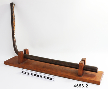
This copper nail, sometimes known as a ‘Dumpy Bolt’ or spike, was salvaged from the hull of the wreck of the “George III”. It dates back to at least 1810. It was found by an abalone diver on the south east coast of Tasmania. The nail would have been used to hold the layers of the ship’s keel frame and the planking together. The nail has been passed from the abalone diver to an interested business man on a trip to the south of Hobart, on again to the business man’s close friend who then donated it to Flagstaff Hill Maritime Village. The metal of nails such as this one, after being in the sea for a long time, become affected by the natural reaction of the sea water, causing it to degenerate and thin, and the stress from the force of the sea over the years alters its shape. Iron nails had been used on ships previously, but they quickly corroded in the salt; ships needed regular, costly and time-consuming maintenance to replace the iron nails. Towards the end of the 18th century the British Navy trialled the use of copper nails, finding them to be very successful. Merchant ships began to adopt this process in the early 19th century, although it made ship building very expensive and was more often used for ships such as the “George III” that sailed on long voyages. The three masted sailing ship “George III” was a convict transport ship built in Deptford, England, in 1810. On 14th December 1834 she left Woolwich, England, bound for Hobart Town, Van Diemen’s Land (Tasmania), under Captain William Hall Moxey. She was carrying 220 male convicts plus crew, guards and their families, totalling 294 persons (another 2 were during the voyage). Amongst the cargo were military stores including several copper drums of gun powder. On 27th January 1835 the “George III” was near the Equator, about half way into her journey. A fire broke out and the gun powder was in danger of explosion, threatening the whole ship. Two convicts braved the heat and smoke, entered the store and seized the gun powder drums, suffering burns for their efforts but saving a probable disaster. The fire destroyed some of the provisions and food was scarce. Many became ill with scurvy and some died during the journey. Nearing the end of their journey on 10th April 1835 the “George III” was headed through the D'Entrecasteaux Channel, south east Tasmania, between the mainland and Bruny Island. She was sailing in the moonlit night to hasten her arrival in port due to the great number of sick on board. She struck uncharted rocks, known only to the local whalers, between Actaeon Reef and Southport Lagoon and within hours began to break up. The ship’s boats were used to first rescue the women and children. Firearms were used to help quell the panic of the convicts below decks and some were killed by the shots. Many convicts, including the sick, were drowned. In all, 133 lives were lost including 5 of the crew, guards and their families. It was the third worst shipping disaster in Tasmanian waters. A monument in honour of the prisoners who perished in the “George III” has been erected, noting the date of the wreck as “Friday 10th April 1835.” (NOTE: there are a few differences between sources regarding dates of the shipwreck, some saying March and others April 1835. There are also differences in the figures of those on board and the number of lives lost.) The copper nail is significant as an example of sailing ship construction; fasteners used in the early 19th century on ships carrying convicts to Australia. The nail is also significant for its association with the ship “George III”. The “George III” is registered on the Australian National Shipwreck Database, ID 7195 as an Historic Shipwreck. She is the third worst shipwreck in Tasmanian waters. She is also associated with Early Australian History and the transportation of convicts to Australia. The incident of the fire on board and the bravery of the convicts in making the gun powder safe is an example of the social character of the people in early Tasmanian colonisation. Copper nail (also called a Dumpy bolt or spike) from the convict ship George III, wrecked in 1835. Nail is long, bent in an ‘L’ shape about 3/5ths along, tapering from both ends to the bend. Both ends are flat and do not taper to a point, nor have a thread. The shorter end has been polished, showing bright copper. There is pitting along the nail and virdigris is evident on the longer, unpolished end. The nail is displayed with the longer section resting on a wooden board between two ‘U’ shaped uprights, the shorter section upright. flagstaff hill, warrnambool, shipwrecked coast, flagstaff hill maritime museum, maritime museum, shipwreck coast, flagstaff hill maritime village, great ocean road, george iii, ship construction, ship nail, 1835 shipwreck, 19th century shipwreck, william moxey, d'entrecasteaux channel, convict transportation, copper nail, dumpy bolt, spike, keel nail -
 Orbost & District Historical Society
black and white photograph, C 1920s
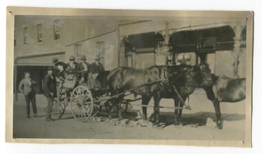
The photograph shows the coach owned by Mr Tom Malinn of Sardine Creek. It is in front of the Orbost Club Hotel in Nicholson Street, Orbost. On lst Juy 1926, Tom Malin took over the horse drawn coach run from Orbost to Delegate. After a few years he obtained an International 2-3 ton truck. On his first trip to Bendoc he did not carry mail, but brought Miss Cunning, the first lady head teacher and collected ballot boxes. On his next trip (March 1930) he made history as the first mailman on this route to deliver mail in a motor vehicle. (info. Bendoc History) Tom and Sophie Malinn farmed at Martin’s Creek. Sophie (nee Jensen) married Tom Malinn in 1926. Sophie’s family had run the historic “Danebo Hotel” at Martin’s Creek for many years, and in 1931, Tom and Sophie began farming at Martin’s Creek, initially cropping maize and beans. The first hotel built in Orbost was the Club in 1885, an old wooden place on the corner built for J. A. Petersen of the Mitchell Hotel Bairnsdale, now known as the Victoria Hotel. Tom Maguire, a stepson of the late Mr. Petersen, carried on the club Hotel Orbost for 5 or 6 years. The property then came into the possession of Alfred Cooper, a Yorkshireman who purchased the freehold about 1890, pulled the building down and erected the present structure.This is a pictorial history horse-drawn transport used widely in Orbost until the late 1920sA black / white photograph of a horse-drawn buggy with four men on the buggy and two mmen standing beside it, It is in front of the Orbost Club Hotel in Nicholson Street, Orbost..on back - "Tom Malinn on coach run"malinn-tom club-hotel-orbost transport-orbost -
 Orbost & District Historical Society
black and white photograph, C1910
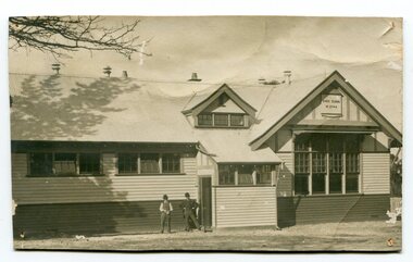
the Orbost State School opened on19th of March 1886. The school had first operated temporarily in a leased building, and on a half-time basis with SS2745 Jarrahmond, The head teacher was Campbell Mackay who remained in charge only until 12th of May 1886. The second head teacher, John Rowe, served until 1908. On 30th of June 1887, a portable room was provided; it being brought to the area by schooner. The school now had accommodation for 30 pupils; the teacher's welfare was considered because quarters of two rooms were attached. As the population increased so did the needs of the school. This was reflected in the provision of a larger classroom in 1898. During 1910-11 the first approaches were made to the Department for the establishment of a Higher Elementary School in Orbost and this became a reality in 1912. Orbost. The Higher Elementary School supplied post-primary education in the district until a high school was built in 1948. When fire destroyed the school in 1941 local halls were used as classrooms until a new school was built, opened by the Hon. A. E. Lind, MLA, on 13th of February 1942. But Orbost continued to develop and the new school was soon overtaxed. This resulted in the erection of two Bristol classrooms in 1947. By 1950, when the school population had reached 500 pupils the opening of the new school at Orbost North was welcomed by all concerned. In 1963 the Department purchased land diagonally opposite the school and developed it as a playing area.This item is associated with education in the Orbost district.A black / white photograph of a large school building with two men standing out the front.orbost-state-school education-orbost -
![Photograph - Photograph, Black and white, Peckham Photographic Studios, Geo Beachcroft, Hanging on up aloft [the] C.B. Pedersen, c. 1935](/media/collectors/4f729f5897f83e0308601603/items/4f72bbce97f83e03086061e1/item-media/581a839ad0cdd11ed4ac0ec3/item-fit-380x285.jpg) Mission to Seafarers Victoria
Mission to Seafarers VictoriaPhotograph - Photograph, Black and white, Peckham Photographic Studios, Geo Beachcroft, Hanging on up aloft [the] C.B. Pedersen, c. 1935
Snapshot in time of tall ship and the relaxed clambering about the rigging by sailors. The C.B. Pedersen is also referred to as a Training Ship for Swedish seamen and cadets. A reference in Annual reports and in Jottings from our log notes that classes in Swedish amongst other languages were offered by the LHLG to members and some of the earliest photographs note Swedish sailors relaxing. The first officer and captain of the C.B. Pedersen are depicted in photograph (0706) on permanent display. In the Sydney Morning Herald, Tuesday 27 April 1937, page 12: "The C. B. Pedersen was built in 1891. It has visited Australia several times, the most recent occasion having been in 1935, when It was anchored in Port Phillip Bay, Victoria, for several weeks, awaiting a suitable cargo. At length the master, (Captain Hjalmar Dahlström) announced that, as no cargo could be obtained he would be prepared to carry passengers in a voyage to Gothenburg, via Torres Strait. Eight persons, including three women and a small boy were accepted as passengers, and signed on as members of the crew at salaries of 1/ a month". Artist Violet Teague was one of the passengers. She painted during the voyage and exhibited her work in 1938. Built in 1891 the C.B Pedersen, a four-masted steel barque (2142 tons) was used as a training Barque. The ship foundered in April 1937, the crew was saved. Several other photographs of the C.B. Pedersen taken by the same studio are held at the State Library of Victoria.Training of seamen has always been of of keen interest to the Mission to Seamen and many cadets have been welcomed over the 20th Century when widespread training was undertaken by a number of seafaring nations. Black and white photograph of 9 men hanging from ropes in the rigging. One man is upside down, another is holding his hat out. The mast is off to the right-hand side of the photograph and there are several ropes and chains.On the back of the photograph in the top left-hand corner is an ink stamp with the text "Peckham Photographic Studios/Geo Beachcroft/Propr./21 Charlotte St./Richmond/Victoria, Australia". In black pen is the text "Hanging on up aloft/C.B.Pedersen".richmond, chains, rope, seafarers, rigging, peckham photographic studios, geo beachcroft propr, cb pedersen, tall ships, captain hjalmar dahlström, windjammer -
 Eltham District Historical Society Inc
Photograph, View at Eltham, Vic, c.1924
Copy of possible Rose Stereograph Co. postcard “View at Eltham, Vic.”, c.1924 looking southwest from Main Road near York Street to Bridge Street and the original 1875 bridge across what is now the Alistair Knox Park The land in the foreground was first bought from the Crown by J.M. Holloway in 1851. The land was sub-divided and called "Little Eltham". Bridge Street was created as part of the sub-division. Most of the sub-division was residential lots but the creek valley was divided into lots for small farms. Council started to buy the land for the Eltham Town park in the early 1960s. The area was used as a garbage tip and filled above the flood plain of the creek. Development of the land for a park began in the early 1970s. The house on the right was owned for many years by the Hill family until Council bought it in the early 1960s. The house was built in the 1850s or 60s. The house on the left stood on what is now the southwest corner of Susan and Bridge Streets. The Braithwaite family was associated with this house. The double line of fencing in the foreground was a continuation of York Street to the creek. The Bridge Street bridge was built in 1875 and replaced in 1958. (Ref: Early view of Little Eltham; Byways of History by Colleen Ison, Publication unk, 24 August 1982) Reproduced on p61 of 'Pioneers & Painters' Date estimated on same as View at Hurstbridge featuring Wattle Valley EstateThis photo forms part of a collection of photographs gathered by the Shire of Eltham for their centenary project book,"Pioneers and Painters: 100 years of the Shire of Eltham" by Alan Marshall (1971). The collection of over 500 images is held in partnership between Eltham District Historical Society and Yarra Plenty Regional Library (Eltham Library) and is now formally known as the 'The Shire of Eltham Pioneers Photograph Collection.' It is significant in being the first community sourced collection representing the places and people of the Shire's first one hundred years.Digital image 120 format B&W negative Prints 17 x 25 cm and 10 x 15 cmsepp, shire of eltham pioneers photograph collection, eltham, bridge street, bridge, alistair knox park, braithwaite, bridge street bridge, eltham town park, hill family home, main road, pioneers and painters, york street -
 Federation University Historical Collection
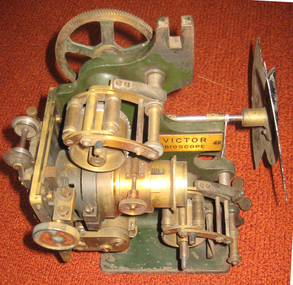
Equipment - Projector, Victor Bioscope, c1910
A Bioscope show was a fairground attraction consisting of a travelling cinema. The heyday of the Bioscope was from the late 1890s until World War I. Bioscope shows were fronted by the largest fairground organs, and these formed the entire public face of the show . A stage was usually in front of the organ, and dancing girls would entertain the crowds between film shows. Films shown in the Bioscope were primitive, and the earliest of these were made by the showmen themselves. Later, films were commercially produced. Bioscope shows were integrated, in Britain at least, into the Variety shows in the huge Music Halls which were built at the end of the nineteenth century. After the Music Hall Strike of 1907 in London, bioscope operators set up a trade union to represent them. There were about seventy operators in London at this point. (http://en.wikipedia.org/wiki/Bioscope_show) The Projector was a rather unreliable piece of apparatus, powered by a variety of light sources, including Calcium Oxide (Lime-Light). A Calcium Carbide Burner, or the rather more superior Carbon Arc. All these methods were highly unpredictable & quite frankly...dangerous! Often resulting in explosions, burning down the entire Show! (which is probably why NO original Shows still exist. Alfred Ball's Bioscope, pictured below, built in 1905 was struck by lightning, shortly after the picture was taken! (http://www.circus-entertainer.co.uk/heritage.htm) In 1909 the first bioscopes pictures were shown at the Ballaarat Mechanics' Institute.Brass and green painted metal film projectorbioscope, vector, entertainment, projector, film, theatre, movie -
 Flagstaff Hill Maritime Museum and Village
Functional object - Wood sample
This oak wood sample is part of the wooden barque, the Grange, built in 1840. The wood sample was recovered from the shipwreck of the Grange in around 1968, 110 years after the Grange was wrecked (see below for further details on the Grange). It is part of the John Chance Collection. THE GRANGE, 1840-1858- The wooden barque ’Grange’ was a three-masted ship built in Scotland in 1840 for international and coastal trade. On March 22, 1858, the Grange set sail from Melbourne under Captain A. Alexander, carrying a cargo of ballast. The barque had left the Heads of Phillip Bay and was heading west along the Victorian coast towards Cape Otway. The ship struck Little Haley’s Reef at Apollo Bay due to a navigational error and was stuck on the rocks. The crew left the ship carrying whatever they could onto the beach. Eventually, the remains of the hull, sails and fittings were salvaged before the wreck of the Grange broke up about a month later. About 110 years later, in 1968, the wreck of the Grange was found by divers from the Underwater Explorers Club of Victoria. They were amazed to find a unique, six to nine pound carronade (type of small cannon) and a cannonball on the site. There have been no other similar carronades recorded. In that same year the anchor of the Grange was recovered by diver John Chance and Mal Brown. The wood sample is significant historically as an example of hardware used when building wooden ships in the early to mid-19th century. The sample is historically significant as an example of the work and trade of blacksmith. The sample is also has significant as it was recovered by John Chance, a diver from the wreck of the Grange in the 1968. Items that come from several wrecks along Victoria's coast have since been donated to the Flagstaff Hill Maritime Village’s museum collection by his family, illustrating this item’s level of historical value. The sample is historically significant for its association with the 1840s wooden barque, the Grange. The Grange is an historical example of a Scottish built vessel used for international and coastal trader of both cargo and passengers in the mid-19th century. The Grange is an example of an early ship, designed with a wooden hull. It is significant as a ship still available to divers along the south coast of Victoria, for research and education purposes. The Grange is an example of a mid-19th century vessel that carried a weapon of defence onboard. Wood sample, oak wood fixed between plates and secured by a washer and bolt. There are five layers, each decreasing in size from base to the top. The bottom is a five-sided copper plate, above it is the oak sample that is crumbling and fragile, then a half-disc metal plate, then a square metal washer, then a round metal bolt head. The metal plate has unequal sides, the longest is parallel to the strait side of the half disc. flagstaff hill, warrnambool, flagstaff hill maritime museum, maritime museum, shipwreck coast, flagstaff hill maritime village, great ocean road, west coast trader, apollo bay, mid-19th century shipwreck, the grange, scottish barque, little henty reef, captain a alexander, underwater explorers club of victoria, 1840s carronade, vhr 5297, coastal trader, wooden shipwreck, john chance, wood sample, wooden ship, oak timber, ship fitting -
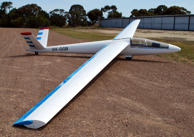 Australian Gliding Museum
Machine - Glider - Sailplane
The Schreder HP 14V is an all metal single seat sailplane designed by Richard Schreder in America. The design is an evolution of Schreder’s metal sailplane designs that date from the late 1950s. Schreder won the United States National Soaring Championship in 1966 in the prototype HP 14. He marketed the glider in kit form in the 1960s and 1970s and allowed Slingsby in the UK to further develop the design for production. Schreder HP14 V, registered as VH-GGB, was built in South Australia by Harry Bache of the Waikerie Gliding Club in the 1970s. Martin Simons, an authority on vintage sailplanes (including Slingsby types), refers to this airframe as “built entirely from scratch”. After Bache, this Schreder HP14V passed on to E.G. Moore and N.L. Lovell at Ararat in Western Victoria, then Graeme Rickert of the Canberra Gliding Club and finally, to Greg O’Sullivan of the Geelong Gliding Club. The glider was first flown on 20 December 1975. It appears to have been flown regularly over its life to 2015 and the cumulative use being 1386 hours flown from 702 launches. The log book does not disclose details of flights except as aggregates of flights and times. Details of notable flights by Bache and Moore et al are not available. However, reports from Rickert and O’Sullivan indicate that a good number of cross-country flights of 300km or longer were achieved in this aircraft. A well-engineered metal sailplane from the 1970s with good soaring performance which was designed for amateur construction. All metal single seat glider sailplane with a distinctive V-tail, finished in a white and blue colour schemeRegistration letters 'GGB' on sides of fuselageaustralian gliding, glider, sailplane, schreder, slingsby, bache, waikerie gliding club, moore, lovell, rickert, o’sullivan, canberra gliding club, geelong gliding club. -
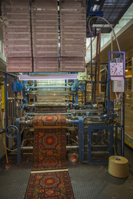 National Wool Museum
Machine - Axminster Carpet Loom, Brintons Ltd (UK), c. 1910
The Axminster Carpet Loom has been set up as a focal point in the centre of the National Wool Museum. The loom was originally built by Brintons in England around 1910 and was initially operating in Geelong in 1960. Brintons designed and built most of their own looms and ancillary equipment. When superseded in 1975 the loom was donated to the Melbourne College of Textiles for weaving training. The College has now donated the loom to the National Wool Museum and Brintons engineering staff has restored it to full working condition. This loom is known as an Axminster gripper loom. The gripper system was invented by Brintons in 1890 and operates using a gripper shaped like a birds beak. This grips the yarn, the yarn is then cut and the gripper swings down to place the tuft into the woven backing. This particular loom also uses a jacquard system for weaving colours. In jacquard weaving, punched cards are used to instruct the loom as to which colour to use. The system was invented by Joseph Jacquard, a silk weaver from Lyon, and was introduced in 1804. It revolutionised pattern weaving as it had the capacity to create intricate patterns through the use of the cards. By 1833 there were approximately 100,000 power-looms used in Great Britain that had been influenced by Jacquards invention. Joseph Jacquard died in 1834. Charles Babbage was later to adapt Jacquards punch-card system to produce a calculator that was the forerunner of todays methods of computer programmingAxminster carpet loom featuring over 1000 Jacquard punch cards and over 100 bobbins of different colours of wool.loom carpet wool, geelong woolbrokers' association, geelong, auction -
 Kew Historical Society Inc
Slide - Residences, 99 Princess Street, 1 Fellows Street, 1979
One of a group of slides taken by members of the Society of built heritage in Kew in 1979-80. The selection of subject matter reflects the priorities of the period. The colour of some slides has degraded. 99 Princes sStreet (1 Fellows Street) was built by the architects Oakden, Addison and Kemp. The Kew Conservation Study (1988) noted that: Erected By Bennie And Olivers, these Two Attached Houses Attracted An Initial Construction N.A.V. of £260. The houses were originally owned and occupied by the architect Henry Kemp, however Kemp appears not to have lived there long because, while he retained ownership for at least a decade, by 1891 George Martin, merchant and bank manager, was recorded as the tenant of No.1 Fellows Street. At that date the N.A.V. for this individual building was £83 and Kemp remained the owner of both properties until at least 1910. Kemp had arrived in Australia in 1886 and this was therefore one of the first of the many buildings he was to design in Melbourne. While late Victorian in date, the houses are of a unified design that is an interesting precursor of the Edwardian architecture produced by Kemp. Somewhat awkwardly composed with steep gables, a rectangular castellated tower and slated single storeyed verandahs projecting from the overall boxlike form, the house contains features common to the 1880s such as the use of polychromy in the brickwork and slates cladding the roof. The building departs from the norm of the time with the use of terracotta tile ridge cappings, and strapwork to the corbelled chimneys.The slides represent a snapshot in time of built architecture in Kew, much of which has changed in the forty-plus period since they were created.Colour positive transparency (slide) of the pair of residences on the corner of Princess Street and Fellows Street in Kew. The point of view is the Fellows Street frontage.comaques, historic houses -- kew (vic.), glenferrie road -- kew (vic.) -
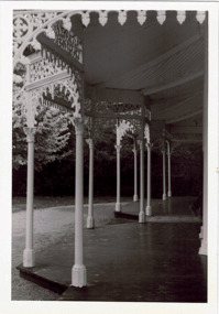 Kew Historical Society Inc
Photograph - Verandah of 'Wimba', 235 Cotham Road, John T Collins, 1979
Although probably built some time earlier, the first mention in the Rate Books of the property later known as 'Wimba Lodge' appears in the entry for 1870 when the property, owned by John Sharpe Denbigh, a civil servant, was given an N.A.V. of £72. Denbigh did however occupy a house in Cotham Road in 1863, and it is possible that was the same premises'. The house was occupied by Sharp until at least May 1876 when the 'family residence ... was auctioned' to Carlington George Edmund Marston, a chemist of Smith Street, Collingwood. At the time of the auction the house was described thus: The residence and grounds of the late J.S. Dendigh, situate in the most elevated part of Cotham Road Kew. The grounds comprise an area of 4a Or 29p or thereabouts, and have a frontage to Cotham-road of 4 chains. The house has two large rooms in front, with 6ft hall built of brick, bay and side windows (plate glass), four rooms of wood behind with slate roofs, bathroom and closets, detached kitchen and servant's room, large shed with washing boiler, pantry and cellar under, brick and cement tank, and the Yan Yean laid onto house and grounds, cowshed, pigstye, &c, the whole securely fenced. First class orchard and flower garden. The paddocks laid with English grasses and drained... .' (Sanderson P. Kew Conservation Study Vol 2)'Wimba' is a single storeyed rendered house. The front entrance is flanked by two polygonal bay windows, and a verandah with a concave corrugated iron roof returns around three facades, and accentuates the projections of the windows. The solid render parapet is very ornate and tall for the date of construction. It has panels of decoration along it and is surmounted by a number of render urns. (Sanderson P. Kew Conservation Study Vol 2)Reverse: "JOHN COLLINS / 11 Anderson Road / Hawthorn East, 3123 / Film 395 Exposure 15A / Kew / Wimba / Front verandah from east / 7-4-79wimba lodge, 235 cotham road -- kew (vic.), john s denbigh, carlington george edmund marston