Showing 692 items
matching measurements
-
 Department of Energy, Environment and Climate Action
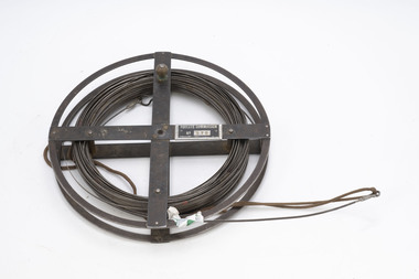
FCV measuring band
Used for measuring distances in the forest. Steel bands (out of tradition were called the chain) were created around 1890. They replaced the traditional Gunter chain. The band could be repaired by soldering slip-on joiners and than and recalibrating.Steel measuring band (1 chain - 66 feet) on metal reelFCV 075forests commission victoria (fcv), assessment, forest measurement, surveying, mapping -
 Department of Energy, Environment and Climate Action
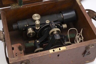
Telescope in wooden box
used for surveyingTelescope used for surveyingStanleyforests commission victoria (fcv), forest measurement, surveying -
 Department of Energy, Environment and Climate Action
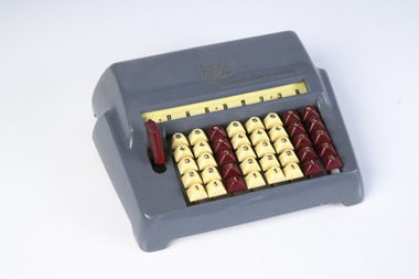
Chadwick-Miller Office Calculator
Used for adding and inventory work The Speedie was a manual adding machine that could not perform subtraction. It consisted of eight columns and five rows of keys in both maroon and ivory. It had a nine digit display that could add up. It could perform multiplication by using repeat action. If you examine the keyboard you’ll note that it only shows numbers 1 through 5. If you want to use numbers 6 through 9 then what you do is hit two keys that add up to that number. Simple office adding machine Made from Bakelite Chadwick-Miller Inc (CMI) was a Boston based importer of low-cost gift items and stationery products sourced mostly from Japan. These products were branded as Chadwick-Miller although CMI was not a manufacturer. It is known that Chadwick-Miller was in business in 1960, although its founding year is unknown. The company dissolved in 2007.Speedie add-a-maticforests commission victoria (fcv), forest measurement -
 Department of Energy, Environment and Climate Action
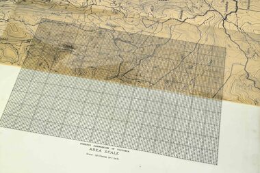
Area Scale - Dot Grid
These transparent sheets were used to measure area on maps at various scales. They were used if a planimeter wasn't available The sheet was overlayed on the map and the shape transferred with a soft China graph or erasable lead pencil The number of "dots" within the shape were counted and converted to an area Each major 1 inch square block contained 100 dots (10 x 10)Transparent dot grid sheet Forests Commission of Victoria Area Scale Scale 30 chains to the inchforests commission victoria (fcv), forest measurement, surveying -
 Department of Energy, Environment and Climate Action
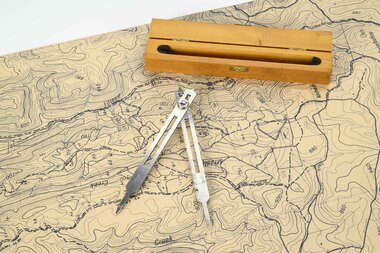
Mapping dividers
used to measure distances on mapsAdjustable stainless steel mapping dividers with wooden boxforests commission victoria (fcv), forest measurement, surveying, mapping -
 Department of Energy, Environment and Climate Action
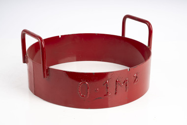
Fuel sampling ring
Used to sample fine fuels on the forest floor. The ring was pushed into the litter to sample 0.1m2Heavy metal ring with sharpened bottom edgeforests commission victoria (fcv), bushfire, forest measurement -
 Department of Energy, Environment and Climate Action
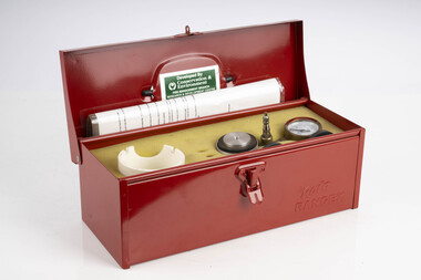
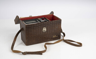
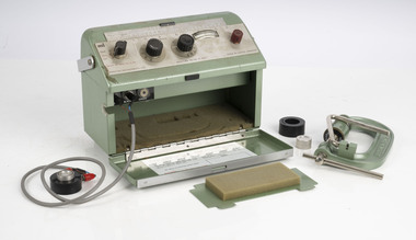
Speedy Moisture meter test kit
Used for pressure testing and recalibrating Speedy Moisture metersKit used pressure test Speedy Moisture metersforests commission victoria (fcv), bushfire, forest measurement -
 Department of Energy, Environment and Climate Action
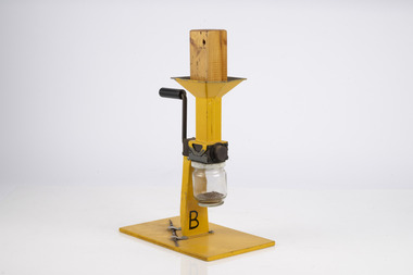
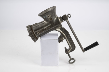
Fuel Mincer
Used to mince fuel samples to measure moisture content Representative samples of fuel such as bark, leaves, twigs etc were minced and the moisture measured The availability of fuel to burn depends largely on its moisture content. When it exceeds 20-25% not much will burn, whereas 12-15% is generally ideal for fuel reduction burning, but if the moisture content drops as low as 7-10% virtually everything will ignite, and fire behaviour becomes extreme. During the afternoon of the Ash Wednesday bushfires on 16 February 1983 fuel moisture contents were recorded at Stawell as low as 2.7%. Fine fuels like leaves and bark can rapidly absorb moisture after a shower of rain, or from the air when the Relative Humidity (RH) is high, and the temperature is low. Conversely, they can also dry out very quickly. So even though the overall fuel quantity in the forest doesn’t change, the fine fuel availability can increase rapidly from zero after rain to many tonnes per hectare as the fuel dries out. This can happen over a few hours on hot and windy days. Heavy fuels like logs on the ground take longer to dry out. Fuel mincer Made at Altona as an alternative design to the commercial Spong Mincer With wooden plug to push fuel into the mincer and glass jar to collect sampleforests commission victoria (fcv), bushfire, forest measurement -
 Department of Energy, Environment and Climate Action
Spong Fuel Mincer
Used to mince fuel samples to measure moisture content Representative samples of fuel such as bark, leaves, twigs etc were minced and the moisture measured The availability of fuel to burn depends largely on its moisture content. When it exceeds 20-25% not much will burn, whereas 12-15% is generally ideal for fuel reduction burning, but if the moisture content drops as low as 7-10% virtually everything will ignite, and fire behaviour becomes extreme. During the afternoon of the Ash Wednesday bushfires on 16 February 1983 fuel moisture contents were recorded at Stawell as low as 2.7%. Fine fuels like leaves and bark can rapidly absorb moisture after a shower of rain, or from the air when the Relative Humidity (RH) is high, and the temperature is low. Conversely, they can also dry out very quickly. So even though the overall fuel quantity in the forest doesn’t change, the fine fuel availability can increase rapidly from zero after rain to many tonnes per hectare as the fuel dries out. This can happen over a few hours on hot and windy days. Heavy fuels like logs on the ground take longer to dry out. Spong No 10 food mincerforests commission victoria (fcv), bushfire, forest measurement -
 Department of Energy, Environment and Climate Action
Electric Fuel Mincer
Used to mince fuel samples to measure moisture content Representative samples of fuel such as bark, leaves, twigs etc were minced and the moisture measured The availability of fuel to burn depends largely on its moisture content. When it exceeds 20-25% not much will burn, whereas 12-15% is generally ideal for fuel reduction burning, but if the moisture content drops as low as 7-10% virtually everything will ignite, and fire behaviour becomes extreme. During the afternoon of the Ash Wednesday bushfires on 16 February 1983 fuel moisture contents were recorded at Stawell as low as 2.7%. Fine fuels like leaves and bark can rapidly absorb moisture after a shower of rain, or from the air when the Relative Humidity (RH) is high, and the temperature is low. Conversely, they can also dry out very quickly. So even though the overall fuel quantity in the forest doesn’t change, the fine fuel availability can increase rapidly from zero after rain to many tonnes per hectare as the fuel dries out. This can happen over a few hours on hot and windy days. Heavy fuels like logs on the ground take longer to dry out. Battery operated Fuel mincer. Plugs into 12 volt car cigarette lighter socket Adaption using parts from commercial food processor Made at Altona as an alternative design to the commercial Spong Mincer Glass jar to collect sampleforests commission victoria (fcv), bushfire, forest measurement -
 Department of Energy, Environment and Climate Action
Fuel Moisture meter
Used to mince fuel samples to measure moisture content Representative samples of fuel such as bark, leaves, twigs etc were minced and the moisture measured The availability of fuel to burn depends largely on its moisture content. When it exceeds 20-25% not much will burn, whereas 12-15% is generally ideal for fuel reduction burning, but if the moisture content drops as low as 7-10% virtually everything will ignite, and fire behaviour becomes extreme. During the afternoon of the Ash Wednesday bushfires on 16 February 1983 fuel moisture contents were recorded at Stawell as low as 2.7%. Fine fuels like leaves and bark can rapidly absorb moisture after a shower of rain, or from the air when the Relative Humidity (RH) is high, and the temperature is low. Conversely, they can also dry out very quickly. So even though the overall fuel quantity in the forest doesn’t change, the fine fuel availability can increase rapidly from zero after rain to many tonnes per hectare as the fuel dries out. This can happen over a few hours on hot and windy days. Heavy fuels like logs on the ground take longer to dry out. Adaption of a timber moisture meter made by the FCV radio lab to measure fuelforests commission victoria (fcv), bushfire, forest measurement -
 Department of Energy, Environment and Climate Action
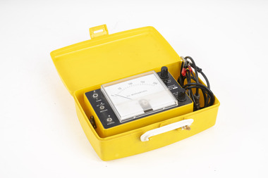
Delton Moisture meter
Used to measure moisture content by electric current resistance Representative samples of fuel such as bark, leaves, twigs etc were minced and the moisture measured The availability of fuel to burn depends largely on its moisture content. When it exceeds 20-25% not much will burn, whereas 12-15% is generally ideal for fuel reduction burning, but if the moisture content drops as low as 7-10% virtually everything will ignite, and fire behaviour becomes extreme. During the afternoon of the Ash Wednesday bushfires on 16 February 1983 fuel moisture contents were recorded at Stawell as low as 2.7%. Fine fuels like leaves and bark can rapidly absorb moisture after a shower of rain, or from the air when the Relative Humidity (RH) is high, and the temperature is low. Conversely, they can also dry out very quickly. So even though the overall fuel quantity in the forest doesn’t change, the fine fuel availability can increase rapidly from zero after rain to many tonnes per hectare as the fuel dries out. This can happen over a few hours on hot and windy days. Heavy fuels like logs on the ground take longer to dry out. Commercial timber moisture meter used to measure fuelDCR9-Tforests commission victoria (fcv), bushfire, forest measurement -
 Department of Energy, Environment and Climate Action
Marconi Moisture meter
Used to measure fuel moisture content Representative samples of fuel such as bark, leaves, twigs etc were minced and the moisture measured The availability of fuel to burn depends largely on its moisture content. When it exceeds 20-25% not much will burn, whereas 12-15% is generally ideal for fuel reduction burning, but if the moisture content drops as low as 7-10% virtually everything will ignite, and fire behaviour becomes extreme. During the afternoon of the Ash Wednesday bushfires on 16 February 1983 fuel moisture contents were recorded at Stawell as low as 2.7%. Fine fuels like leaves and bark can rapidly absorb moisture after a shower of rain, or from the air when the Relative Humidity (RH) is high, and the temperature is low. Conversely, they can also dry out very quickly. So even though the overall fuel quantity in the forest doesn’t change, the fine fuel availability can increase rapidly from zero after rain to many tonnes per hectare as the fuel dries out. This can happen over a few hours on hot and windy days. Heavy fuels like logs on the ground take longer to dry out. Adaption of a commercial timber moisture meter measure fuelTF 933 Cforests commission victoria (fcv), bushfire, forest measurement -
 Department of Energy, Environment and Climate Action
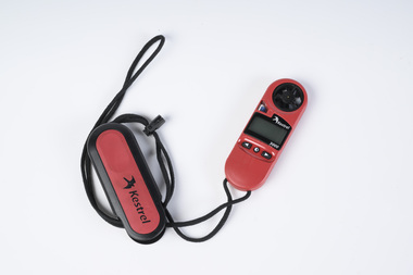
Anemometer
Used to measure wind speed which is an important factor in fire behaviourHand held battery operated anemometer used to measure wind speedKestrel 3000forests commission victoria (fcv), bushfire, forest measurement -
 Department of Energy, Environment and Climate Action
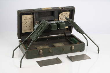
Hasselblad aerial camera
Aerial photos were used to make maps of forest types, timber resources, to survey logging areas and regeneration, to mark boundaries of public land and new plantations, to identify new roads and tracks, as well as for fire suppression. Infrared film was sometimes used to monitor insect and disease attack. The images needed to sharp, with high contrast, and in a large format (most were printed in B&W on 9-inch by 9-inch glossy photographic paper) with at least a 60% overlap to enable stereoscopic viewing and with a 20-30% side lap to allow for aircraft drift. Preferably, the photo scale was close to the final map scale avoid to problems when enlarging and to reduce distortion. Something was needed to supplement the very expensive and infrequent large-area photography programs. From the mid-1960s Victorian foresters began experimenting with small format 70mm and 35mm cameras which proved simple, practical, cheap and flexible. It was found that any SLR camera could be used provided it had a good quality lens and fast shutter speed (preferably down to 1/1000 second). Motorised cameras with a large film capacity had obvious advantages and were essential when access to the camera was not possible during flight. It is also essential for the shutter to operate at low temperatures and those lubricated with silicones were recommended. Components of a typical FCV Divisional Office system included – A Hasselblad or Vinten 70 mm format aerial camera with a focal plane shutter which could be electrically operated. Interchangeable lenses to allow for different photo scales and flying heights. Several large film magazines, which were loaded in a darkroom, each with a capacity of 100 feet or approximately 500 frames. A remote control for the camera in single-shot mode or automatic firing at selected intervals of 2 to 50 seconds. It also needed a frame counter. A light aircraft was modified with an internal mounting for the camera to keep it level and steady. Often a hole was cut through the floor for the lens. The aircraft also needed an inbuilt 12 Volt DC battery to operate the motorised camera shutter. The front passenger seat was generally removed to improve access to the camera. An Aldis drift sight was also fitted. This might be likened to an inverted periscope and is used to determine drift, to facilitate accurate navigation along flight lines and to determine the exposure interval for stereoscopic overlap. This item is kept at Traralgon.Hasselblad 500 ELM camera with 70mm lens, film pack, motor drive and battery In 1964 Hasselblad started production of a motorized camera, the 500 EL The EL/M is a modified version of the EL, "M" means modified, "EL" electric. Perhaps the most famous use of the Hasselblad camera was during the Apollo program missions when man first landed on the Moon. Almost all of the still photographs taken during these missions used modified Hasselblad cameras. forests commission victoria (fcv), forest measurement, surveying, mapping -
 Department of Energy, Environment and Climate Action
Foldable Stereoscope
This stereoscope was used to view a pair of separate and overlapping aerial photos as a single three-dimensional image. This smaller foldable unit could be easily used in the field but larger, mirror stereoscope was used in offices. The aerial images were used to map forest types, timber stands, new roads and tracks, firebreaks, boundaries of timber harvesting, plantations, bushfires, insect and disease attack and so on In 1928, the Forests Commission undertook its first major aerial photography project over 15,000 acres of forest which is said to be the first of its kind in Australia. During the Second World War, large areas of Victoria were photographed by RAAF and used to produce orthophoto maps. By 1945 aerial photography of 13,000 square miles (3.4 M ha) was completed, including much of the inaccessible eastern forests. The Forests Commission started developing its own small format photography in the early 1970s. Simple, cheap and rapid methods of obtaining photographs using 70mm and 35mm cameras were developedFoldable plastic stereoscope in box Benallaforests commission victoria (fcv), surveying, forest measurement -
 Department of Energy, Environment and Climate Action
Stereoscope
This stereoscope was used to view a pair of separate and overlapping aerial photos as a single three-dimensional image. Smaller units and could be easily used in the field but this larger, mirror stereoscope was used in offices. The aerial images were used to map forest types, timber stands, new roads and tracks, firebreaks, boundaries of timber harvesting, plantations, bushfires, insect and disease attack and so on In 1928, the Forests Commission undertook its first major aerial photography project over 15,000 acres of forest which is said to be the first of its kind in Australia. During the Second World War, large areas of Victoria were photographed by RAAF and used to produce orthophoto maps. By 1945 aerial photography of 13,000 square miles (3.4 M ha) was completed, including much of the inaccessible eastern forests. The Forests Commission started developing its own small format photography in the early 1970s. Simple, cheap and rapid methods of obtaining photographs using 70mm and 35mm cameras were developedFoldable metal stereoscope in wooden box with mirror covers Ex Dept of Defenceforests commission victoria (fcv), surveying, forest measurement -
 Department of Energy, Environment and Climate Action
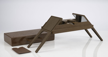
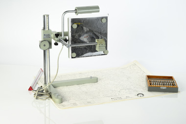
Zeiss Sketchmaster
The Zeiss Sketchmaster was used to transfer information from aerial photographs onto scale maps. The operator views the aerial photograph and the map simultaneously and manually traces detail from the photograph onto the map. It utilises the principle of the camera lucida, patented in 1806. Various lens combinations were used on a to adjust for scale and then “rubber sheet” the image to line up topographic features like streams and roads. The photo information was then laboriously transferred using a light table onto large A0 paper maps or translucent drafting film. The maps were later hand coloured with either Derwent pencils or delicately painted with Pelikan ink wash. This item is kept at Erica.Zeiss Sketchmaster. c1970s. Includes adjustable stand, various lens in sperate box, adjustable light, map holder and magnetsforests commission victoria (fcv), forest measurement, mapping, surveying -
 Department of Energy, Environment and Climate Action
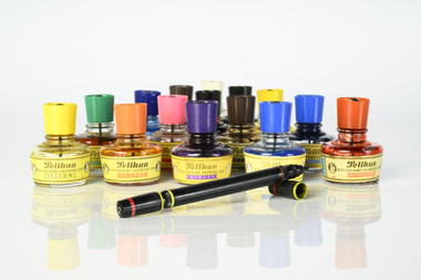
Coloured mapping inks and pens
Coloured ink used to mark lines of paper maps. Could be used in pen or as a "wash" to colour areas with a soft sable hair paint brush Strict cartographic guidance was provided by the FCV’s 1947 publication - “Handbook of Conventional Signs and Symbols for Use in Forest Mapping and Plan Drawing”. It was slow and exacting work but very rewarding.Pelikan coloured inks in small glass bottlesPelikan forests commission victoria (fcv), mapping, forest measurement, surveying -
 Moorabbin Air Museum
Book - Aircraft structural materials, The Hardness of Metals
Explanation of hardness measurement in terms of basic physical properties of metals, circa 1951non-fictionExplanation of hardness measurement in terms of basic physical properties of metals, circa 1951 -
 Surrey Hills Historical Society Collection
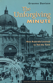
Book - The Unforgiving Minute: How Australia Learned to Tell the Time
Drawing on a wide range of theoretical insights and primary sources, "The Unforgiving Minute" offers an original interpretation of Australian history. It examines time telling from the convict era to the 1990's. As the convict era drew to an end, the colonial governors looked to clocks as the mechanical policemen of an emerging free society. Fifty years later, as railways and telegraphs began to spread across the land, and pocket watches appeared on the waistcoats of working men, colonial society began to keep stricter hours of work and play, and to teach its children the virtue of punctuality. In the early 20th century, punch clocks and time-switches laid the basis for new patterns of work in the factory and the home. Now, in the 1990s, the "faceless clocks" in computers and automated control systems have created a "postmodern" time regime that is both more flexible, and more demanding, than its predecessors.a small book of 21.5 cm; 160pnon-fictionDrawing on a wide range of theoretical insights and primary sources, "The Unforgiving Minute" offers an original interpretation of Australian history. It examines time telling from the convict era to the 1990's. As the convict era drew to an end, the colonial governors looked to clocks as the mechanical policemen of an emerging free society. Fifty years later, as railways and telegraphs began to spread across the land, and pocket watches appeared on the waistcoats of working men, colonial society began to keep stricter hours of work and play, and to teach its children the virtue of punctuality. In the early 20th century, punch clocks and time-switches laid the basis for new patterns of work in the factory and the home. Now, in the 1990s, the "faceless clocks" in computers and automated control systems have created a "postmodern" time regime that is both more flexible, and more demanding, than its predecessors. time measurements -- social aspects -- australia -- history, clocks and watches -- social aspects -- australia -- history, australia -- social conditions, graeme davison -
 Buninyong Visitor Information Centre
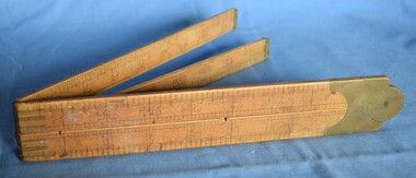
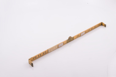
Tool - Ruler, Folding ruler
Used within the Nicholls family.A wooden carpenter's ruler folds into four nine-inch sections with precision made brass hinges.Paper label inscribed 'Please keep. Donated by Harry Nicholls. woodwork, carpentry, rulers, measurement -
Moorabbin Air Museum
Document (Item) - Aero 1677 class 629.13 brief notes on flight measurement at high mach numbers, Royal aircraft establishment Farnborough Hants
-
 Moorabbin Air Museum
Document - (SP) AAP 7002.028-8 Basic Electronic Technology and Testing Practices Fundamental Measurements
-
 Forests Commission Retired Personnel Association (FCRPA)
Basal Area Angle Gauge
Foresters usually measure the diameter of trees at Breast Height – traditionally 4 foot, 6 inches – now 1.3 m – which is termed Diameter Breast Height Over Bark (DBHOB). Basal Area is the cross section of the tree trunk at breast height, and the sum for the stand or group of trees is expressed square feet per acre (after 1973 it was expressed in square metres per hectare). Lots of skinny trees, or a few fat ones, can have the same Basal Area, but when combined with the number of stems, Basal Area is a good indicator of stand density. Two common methods are used to measure of Basal Area – fixed area plots and angle count sampling. 1. Fixed area plots require setting out a small area, commonly 50 m x 20 m, and measuring all the trees at breast height, and doing some quick sums. 2. Angle count sampling involves a simple sweep of the forest from a fixed sampling point using a relascope, dendrometer sight, angle gauge, or glass wedge prism. This wooden builders ruler has been shaped at one end to create a shallow angle (usually less than 3 degrees). Standing in one spot, a sweep is made with the wedge held to the eye, and trees are counted as either “in” or “out”. The number of trees is multiplied by conversion factor of the wedge (10 in this case) to estimate basal area. It’s very quick and effective.Basal Area Angle Gauge The two ends fold up and one end (on the right) has been reduced in width to create a shallow angle for the viewer Home made by cutting down a wooden builder's ruler Many forestry students made their own Basal Area Angle Gauges and its thought this may be oneforest measurement, forests commission victoria (fcv) -
 Moorabbin Air Museum
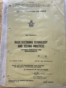
Document - (SP) AAP 7002.028-12 Basic Electronic Technology and Testing Practices Antenna Principles and Measurements, RAAF
-
National Wool Museum
Book, Mr T. B.Harmsworth et al, Wool and mohair - producing better natural fibres 2nd ed, 1990
Thomas Harmsworth and Graham Day: "Wool and mohair - producing better natural fibres 2nd ed." 1990.Book, 222pp. Softcover printed with colour illustrations of sheep and goats.K Gallowaysheep - australian goats wool - characteristics wool - measurement wool growing shearing, australian poll dorset association, mohair, angora, galloway, mr ken, sheep - australian, goats, wool - characteristics, wool - measurement, wool growing, shearing -
 Alfred Hospital Nurses League - Nursing Archive
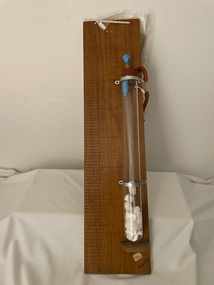
Equipment - Thoracic suction measurement unit, Bookcase 1, shelf 4, AHNL Archives Room 8, unknown
suction regulating deviceOf significance to AHNL as similar to equipment used by nursesLarge glass test tube, with rubber stopper with two holes in top. Through one hole is inserted a long hollow glass tube, through the other hole is inserted a plastic y connector. On one arm of y connector is a short length of orange rubber tubbing, to the other end of this tubing is another larger y connection, with another short length of orange rubber tubing, with a metal clamp attached to bottom. The test-tube is attached to a varnished wooden board by two metal brackets. At the base of the test tube is a small wooden shelf for protection. On this backboard is a marked gradient of 60 cms. Two instruction diagrams are attached. Old catalogue numbermedical equipment, surgical drainage, suction regulator, thoracic surgery -
 Bendigo Historical Society Inc.
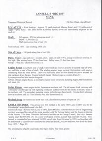
Document - LANSELL'S BIG 180 MINE - CONDENSED HISTORICAL RECORD OF LANSELL'S BIG 180 MINE
Two handwritten and three typed copies of a Condensed Historical Record of Lansell's Big 180 Mine on the New Chum Line of Reef. Notes include location, shaft, first worked, size of lease, plant, engine house, boiler rooms, mullock heap, early history, Prominent, best gold, underground connections, pressurised hot water, diamond drill bores and a table with depths and the increase in temperature with the depth (in Fahr). Albert Richardson Collection. document, gold, lansell's big 180 mine, lansell's big 180 mine, condensed historical record of lansell's big 180 mine, wittscheibe, ballerstadt, ernst mueller, theodore ballerstadt, george lansell, north old chum, victoria quartz, mines dept special edition 'australian mining standard' 1/6/1899, mines dept booklet 'bendigo goldfield' 1936, quarterly reports, lansell's 180 mine 'transverse sections, annals of bendigo mining sections, a richardson's observations from old photographs and measurements of mining plans, measurements taked from caleb thomas' report mines dept 1875, 'report on observation of underground temperature at bendigo' james stirling government geologist 1899, a richardson -
 Bendigo Historical Society Inc.
Document - NORTH JOHNSONS MINE - NOTES ON THE NORTH JOHNSONS MINE
One typed, one handwritten and one handwritten carbon copy of notes on the North Johnsons Mine on the Garden Gully Line of Reef. Notes include size of lease (which was very small, only 83 yards along the line of reef, and the late 1890's absorbed the Rose of Denmark lease, the next mine north, of 57 yeards along the line of reef, Depth of shaft, height of Sill, Locality, Plant, Early History, Prominence, Best Gold, Total Gold Yield and Dividends,Underground Connections and References. Albert Richardson Collection. document, gold, north johnsons mine, north johnsons mine, garden gully line of reef, rose of denmark, camerons reef, dagmar reef, johnsons no 1, johnsons no 2, special edition australian mining standard 1/6/1899, mines dept booklet bendigo goldfield geo brown 1936, mines dept quarterly and annual reports, annals of bendigo mining sections 1866 - 1917, a richardson, e j dunn's special report no 1 measurements taken from north johnsons mine transverse section 22/9/1892, wood & mcnair sharebrokers plan of leases of portion of bendigo goldfield to 4/5/1912