Showing 25577 items matching "plenty-township-estate"
-
 Bacchus Marsh & District Historical Society
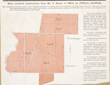
Map, Bullengarook Estate Property Sale. 1911
Bullengarook is a locality located 19 kilometers north of Bacchus Marsh. Pastoral leases for European colonists were granted to people for this area from around the 1840s.The Bullengarook Estate was part of these early pastoral holdings. By the 1900s the property had been owned by the Skene family for a number of years. In early 1911 the property then consisting of 300 acres and the homestead upon it was offered for sale in one lot. It appears however that the sale of the property did not go through in 1911. It was later leased by Thomas Skene to a Mr Coutts in 1915 and ultimately and at a later stage the property was sold by the Skene family.A single page paper map showing land allotments for sale from the Bullengarook Estate. The map is pasted into a bound volume containing 76 maps or plans in total. High resolution digital image stored on BMDHS computer network. land sales bacchus marsh, bullengarook land sales, bullengarook estate, bullengarook vic history -
 Greensborough Historical Society
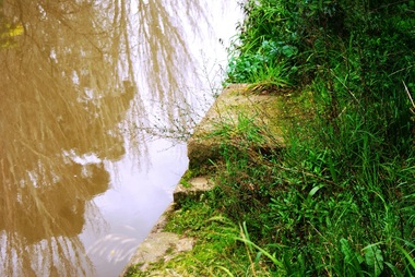
Photograph - Digital image, Marilyn Smith, Plenty River bank at Greensborough 2015; Diving platform, 16/08/2015
Steps on the Plenty River embankment in Greensborough, part of the old Plenty River pool, this is the base of the diving platform. A River bank stabilisation project along the Plenty River at Greensborough was conducted by Melbourne Water in 2015.Digital copy of colour photographplenty river, melbourne water -
 Whitehorse Historical Society Inc.
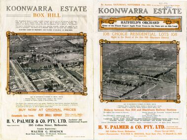
Document - Real Estate Notice, Koonwarra Estate Hatfield's Orchard, C1924
Land brochure giving details of auction of Koonwarra EstateLand brochure giving details of auction of Koonwarra Estate known as Hatfield's OrchardLand brochure giving details of auction of Koonwarra Estate land sales, koonwarra estate, hatfield's orchard, middleborough road, blackburn, canterbury road, laburnum street, hillside crescent, salisbury avenue, rymer street, pakenham street, park street, myrtle grove, h. v. palmer & co. pty. ltd., hiscock, walter g -
 Whitehorse Historical Society Inc.
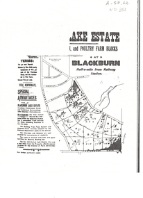
Document, Lake Estate
Plan of Lake Estate, Blackburn.Plan of Lake Estate, Blackburn. Poultry and farm blocks for sale. Incomplete photocopy.Plan of Lake Estate, Blackburn.auctions, lake estate, blackburn, blackburn lake sanctuary, central road, gordon crescent, wolseley crescent, wellington avenue, blackburn road, lake road, canterbury road -
 Whitehorse Historical Society Inc.
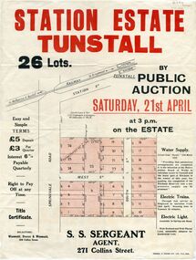
Pamphlet - Document, Station Estate Tunstall, 1923
Land Plan for auction of estate at Tunstall.Land Plan for auction of estate at Tunstall. Original in Haughton Maps, Latrobe LibraryLand Plan for auction of estate at Tunstall. auctions, station estate tunstall, s. s. sergeant (agent) -
 Whitehorse Historical Society Inc.
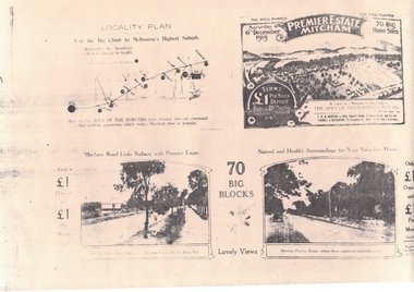
Document, Premier Estate Mitcham
Brochure advertising auction of 70 big home sitesBrochure advertising auction of 70 big home sites, Premier Estate Mitcham.Brochure advertising auction of 70 big home sitesauctions, t.r.b. morton & son, coghill & haughton -
 Whitehorse Historical Society Inc.
Newspaper - Article, Real estate between Box Hill and Croydon, 26/06/1935
Article dealing with real estate development in the suburbs between Box Hill and Croydon.real estate, box hill, ringwood, croydon, blackburn, mitcham -
 Ballarat Heritage Services
Photograph - Digital photograph, Fellmonger's Township
Fellmonger's Township was on the outskirts of Ballarat East near Gong Gong. Martin Hosking, Dennis Kinnane, Quinns, O'Deas, and Nestors lived in this location. Hewitt's soap works were located on the banks of the Yarrowee Creek on the Daylesford - Ballarat road and were obviously near a fellmongering operation from which the area derives its name.Black and white photograph of the town of Fellmongers, near Ballarat.fellmongers, ballarat east, gong gong -
![Map, Liquidator's sale, 1896. [Woolpack Estate, Bacchus Marsh]](/media/collectors/5e461d8021ea67224c82f2a1/items/6779ee97032b72846b5995f2/item-media/6779ef33032b72846b599b30/item-fit-380x285.jpg) Bacchus Marsh & District Historical Society
Bacchus Marsh & District Historical SocietyMap, Liquidator's sale, 1896. [Woolpack Estate, Bacchus Marsh]
The Woolpack Estate was an area of land owned by various landowners in the Bacchus Marsh area since the early Colonial period of the 1840s. The area was located on the eastern side of the Bacchus Marsh township about 7 kilometers from the town. The Lerderderg River ran through part of the land and so did the Melbourne to Ballarat Road. The historic Woolpack Inn associated with James Crook was also located on this land. By 1896 150 acres of this land was under the control of liquidators for the Federal Bank of Australasia who instructed that the land be sub-divided and sold in lots by public auction. A successful sale was held on 24 June 1896. Most of the blocks of land were sold for higher than expected prices and most of the buyers were people from the town and district of Bacchus Marsh. The map includes various details about the land which is described on the map as an "important sale of rich alluvial irrigable flat land in the Bacchus Marsh Valley, and other properties". The auction was conducted by the local agents W. Anderson and Bence in conjunction with Pearce Brothers also of Bacchus Marsh.A single page paper map showing a plan of 150 acres of land from the Woolpack Estate to be sold in various lots in June 1896. Also shown on the map are lots for sale at Robinson's Farm on Coimadai Creek and allotments near Bacchus Marsh railway station, including lots on Government Road (East Maddingley Road), View Street and Government Road (Parwan Road). No scale provided. The map is pasted into a bound volume containing 76 maps or plans in total. High resolution digital image stored on BMDHS computer network. land sales bacchus marsh, bacchus marsh victoria maps, woolpack estate bacchus marsh victoria -
 Greensborough Historical Society
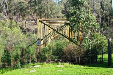
Photograph - Photograph - Digital Image, Marilyn Smith, Aqueduct crossing the Plenty River, Greensborough 2019, 02/07/2019
The aqueduct crossing the Plenty River, 2019, overgrown with vegetation. Originally part of the Maroondah Aqueduct pipeline, all that remains is the bridge that once carried the pipe over the Plenty River. This photograph was taken from the Plenty River Trail in Greensborough. 3 colour digital photographsplenty river trail, maroondah pipetrack, maroondah aqueduct, plenty river, graffiti -
 Greensborough Historical Society
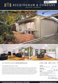
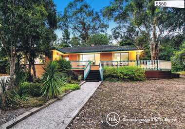
Advertising Leaflet, 29 Fricker Avenue Greensborough, 26/05/2018
29 Fricker Avenue Greensborough. 4 bedroom home, auctioned 26 May 2018, P.I., asking $810,000; sold July 2018 for $770,000Real estate advertising leaflet, 2 sheets, both printed in colour, 1 on both sidesfricker avenue greensborough -
 Greensborough Historical Society
Advertising Leaflet, 5 Willis Street Greensborough, 13/04/2013
5 Willis Street Greensborough Four bedroom home, sold for $693,000 13/04/2013Real estate advertising leaflet, 1 sheet, printed in colour both sides. 2 copieswillis street greensborough, greenhills -
 Melton City Libraries
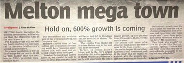
Newspaper, Development of Melton Newspaper articles, 2011, 2015
Newspaper articles from Melton leader and Star Real Estate relating to the development of Melton Southlandscapes of significance -
 Bacchus Marsh & District Historical Society
Map, Bacchus Marsh Township and Nearby Districts Maps Volume
This volume of maps is believed to have been compiled by staff at the Shire of Bacchus Marsh and was presumably used to inform and assist Shire staff and Councillors in the carriage of their duties.This collection of maps are significant due to their rarity as many of them are unique maps made for local purposes in the Bacchus Marsh region. They are also of strong research value containing a wide variety of information including landholders, land sales, infrastructure, such as roads, bridges, public, commercial and private buildings, houses, land use, and geographic features over multiple decades from the late nineteen century into the middle part of the twentieth century.One bound volume of maps comprising cadastral maps, (indicating property owners and land boundaries), land plans and real estate auction plans and advertising material, and other maps indicating major infrastructure like proposed roads and irrigation areas. Most of the maps and plans are of Bacchus Marsh and nearby areas but some maps are of nearby towns such as Melton, Ballan and Blackwood. The volume comprises 52 pages. Most pages have a single map or plan pasted onto it but some contain 2 or 3 different maps. There are 81 maps in total. Map 1 Liquidators Sale 1896. Map 2. Woodside Estate Sale 1913. maps, maps bacchus marsh, maps bacchus marsh region -
 City of Moorabbin Historical Society (Operating the Box Cottage Museum)
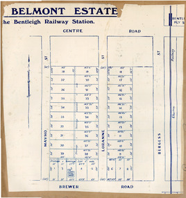
Flyer, 1922
At the end of World War One, there was a renewed interest in residential land and a number of estates opened up in the Municipality of Moorabbin. Belmont eState, Bentleigh was auction on 9 December 1922.Example of the progress of the Municipality of MoorabbinAdvertising flyer for auction of real estate sales - plan of building blocks for saleBelmont Estate, Bentleigh Railway Stationmavho street, loranne street, brewer road, bentleigh, auction, bentleigh railway station, real estate -
 City of Kingston
Pamphlet - Colour, Roy Dunn Pty. Ltd, Central Corner Estate Moorabbin and Highett, c. 1923
Sales plan for land in the suburbs of Highett and Moorabbin, bordered by Point Nepean Road and Wickham Road East incorporating William StreetThe developing urban area of Highett and Moorabbin within the City of Kingston. This land sale pamphlet illustrates the subdivision of land within the municipality and the changing demographic of the district as new houses are constructed close to infrastructure.Colour pamphlet advertising for private sale land in the Central Corner Estate in Moorabbin and Highett. Incorporates a map of the estate bordered by Point Nepean Road and Wickham Road East, with subdivisions also available on both sides of William Street. Handwritten in blue pencil on subdivision plan: a tick is drawn on subdivisions 2-18 Handwritten in blue pencil on subdivision 6: a box with an x inside Handwritten in blue pencil on subdivisions 10 and 12: S Handwritten in black ink on front page: [indecipherable] / McKittricks Handwritten in grey pencil on rear page: McKilhick / Nepean Rd Handwritten in grey pencil on rear page upside down: 160000 / 15 8300 [crossed out] land sales, estate, highett, moorabbin -
 Ringwood and District Historical Society
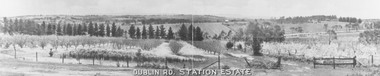
Photograph, Dublin Rd. Station Estate brochure. c.1923
Printed on picture, "Dublin Rd. Station Estate" . Written below picture, "c1923". -
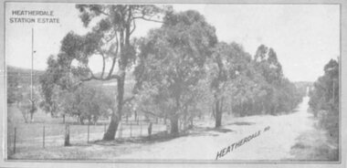 Ringwood and District Historical Society
Photograph, Heatherdale Station Estate - 1924
Catalogue card reads, "Heatherdale Station Estate - 1924. 2nd February 1924". -
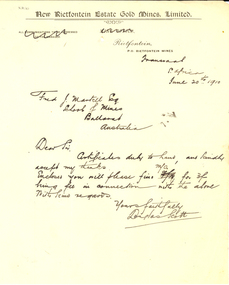 Federation University Historical Collection
Letter, Douglas Scott, New Rietfontontein Estate Gold Mines Limited Correspondence and Letterhead, 1910, 20/06/1910
Letter from Douglas Scott to the Ballarat School of Mines concerning safe delivery of certificates. Correspondence on New Rietfontontein Estate Gold Mines Limited letterhead to the Ballarat School of Mines.new rietfontontein estate gold mines limited, letterhead, douglas scott, frederick martell, the rand, alumni, transvaal, south africa, rietfontein -
Ringwood and District Historical Society
Legal record - Conditions of Sale (C.E.Carter), Tunstall , Lot 62 on Plan of Subdivision 10994, C.E.Carter ( Estate of Bridget Kelly) to Miss F.M.Sharp, 1943
Particulars and Conditions of Sale of Property , from C.E.Carter ( Estate of Bridget Kelly) to Miss F.M.Sharp. -
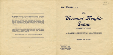 Whitehorse Historical Society Inc.
Document, Vermont Heights Estate
Sale brochure for 'Vermont Heights Estate', Vermont,Sale brochure for 'Vermont Heights Estate', Vermont, 48 allotments. Agent: Drake & Co.Sale brochure for 'Vermont Heights Estate', Vermont,land sales, vermont heights estate, centre road, vermont, penllyne avenue -
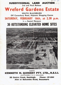 Whitehorse Historical Society Inc.
Document, Wreford Gardens Estate, 1/02/1963 12:00:00 AM
Wreford Gardens Estate,Pamphlet advertising land for sale on Wreford Gardens Estate, Blackburn 16th February, 1963Wreford Gardens Estate,land sales, wreford gardens estate, blackburn south, abercromby road, edinburgh road, baird court, barrina street -
 Whitehorse Historical Society Inc.
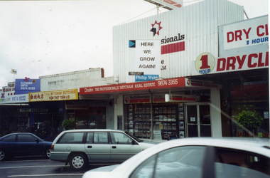
Photograph, Drake Real Estate, 1/09/2001 12:00:00 AM
Coloured photograph of Drake Real Estate business in Whitehorse Road, Mitcham being expanded.drake real estate -
 Whitehorse Historical Society Inc.
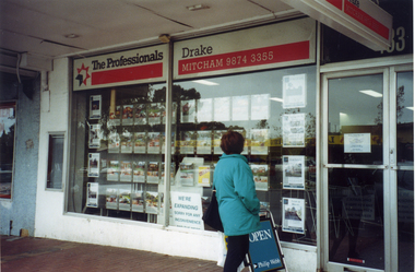
Photograph, Drake Real Estate, 1/09/2001 12:00:00 AM
Coloured photograph of Drake Real Estate business in Whitehorse Road, Mitcham, being expandeddrake real estate -
 Whitehorse Historical Society Inc.
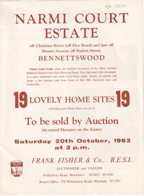
Document, Narmi Court Estate, Bennettswood, 20/10/1962 12:00:00 AM
Auction of 19 home sites called Narmi Court Estate, Bennettswood by Frank Fisher.narmi court estate, bennettswood, frank fisher co. -
 Whitehorse Historical Society Inc.
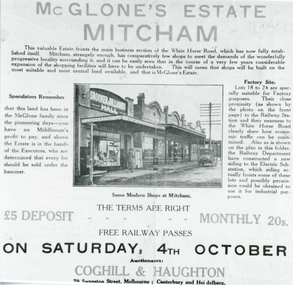
Photograph, McGlone's Estate, 4/10/1924 12:00:00 AM
Black and white photo of sales brochure for McGlone's Estate, Mitcham, 4/10/1924mcglone john, mcglone estate, coghill & haughton -
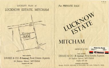 Whitehorse Historical Society Inc.
Pamphlet - Advertising brochure, Lucknow Estate, unknown
Brochure advertising sale of Lucknow Estate Mitcham. 90 lots. Agent: Drake & CoBrochure advertising sale of Lucknow Estate Mitcham. 90 lots. Agent: Drake & CoBrochure advertising sale of Lucknow Estate Mitcham. 90 lots. Agent: Drake & Coland sales, lucknow estate, lucknow street, owen street, brian street, ross street, ronald street, lucknow court -
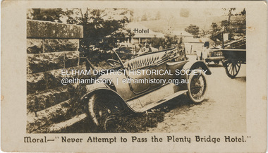 Eltham District Historical Society Inc
Photograph - Business Card, C. Aarons, Moral - "Never Attempt to Pass the Plenty Bridge Hotel.", c.1920
Circa 1920 Business Card: Plenty Bridge Hotel, Lower Plenty via Heidelberg C. Aarons, Licensee Humorous business card warning motorists of the dire consequences attempting to negotiate the Plenty River Bridge should they decide to pass by the hotel with stopping.marg ball collection, c. aarons, car crash, golf club hotel, lower plenty bridge hotel, plenty bridge hotel, lower plenty bridge -
 Greensborough Historical Society
Photograph - Digital Image, Marilyn Smith, Plenty River at the aqueduct crossing Greensborough 2019, 02/07/2019
The Plenty River at the aqueduct crossing, 2019, showing graffiti on the river bank rocks. Originally part of the Maroondah Aqueduct pipeline, all that remains is the bridge that once carried the pipe over the Plenty River. This photograph was taken from the Plenty River Trail in Greensborough. 2 colour digital photographsplenty river trail, maroondah pipetrack, maroondah aqueduct, plenty river, graffiti -
 Eltham District Historical Society Inc
Photograph, Looking east from the northern side of Lower Plenty Road (opposite Bannockburn Road) as it crosses the Watsonia Drain, Viewbank, c.1965, 1965c
Transmission power lines visible in distance behind the Lower Plenty Hotel (in centre upper) and parts of Heidelberg Golf Club. In the foreground a bulldozer can be seen commencing roadworks for the re-alignment of Lower Plenty Road for the new Lower Plenty Bridge crossing.Medium format 120 6x6 black and white negative film, 1 frameheidelberg golf club, lower plenty, lower plenty hotel, road construction, viewbank, watsonia drain