Showing 2155 items matching " flooding"
-
 Dandenong & District Historical Society
Journal, Dandenong & District Historical Society, Gipps-Land Gate Vol44 No1, 2017
... Letter To The Editor Floods 1951 President's Report - Our New Home Vale: Thelma Keys Norden Motor Body Works The Ordish Family In Dandenong Harking Back 75 Years ...Letter To The Editor Floods 1951 President's Report - Our New Home Vale: Thelma Keys Norden Motor Body Works The Ordish Family In Dandenong Harking Back 75 Years Gipps-Land Gate Vol44 No1 Journal Dandenong & District Historical Society ...An interesting group of Early Dandenong Personalities, Places and EventsA5 size publication of the Gipps-Land Gate, April, 2017 featuring an old picture of Dandenong on the cover. Letter To The Editor Floods 1951 President's Report - Our New Home Vale: Thelma Keys Norden Motor Body Works The Ordish Family In Dandenong Harking Back 75 Years An interesting group of Early Dandenong Personalities, Places and Eventshotel history, early education in dandenong, interesting milestones, family histories -
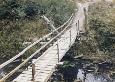 Eltham District Historical Society Inc
Colour Print, David Taylor, Footbridge over the Diamond Creek, Dalton Street Lane, Eltham, c.1976
... The footbridge over the creek was regularly subjected to damage or washed away during floods. A more substantive and flood resistant footbridge has since been erected. ...The footbridge over the creek was regularly subjected to damage or washed away during floods. A more substantive and flood resistant footbridge has since been erected. ...The laneway past Skipper's house, an extension of Dalton Street on the western side of Main Road, has long been a regular route for Eltham High School students heading to and from school. Its present day name is Wingrove Park Trail. The footbridge over the creek was regularly subjected to damage or washed away during floods. A more substantive and flood resistant footbridge has since been erected. david taylor collection, eltham, wingrove park trail, dalton street lane, dalton street footbridge -
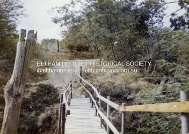 Eltham District Historical Society Inc
Colour Print, David Taylor, Footbridge over the Diamond Creek, Dalton Street Lane, Eltham. View heading east towards Main Road, c.1976
... The footbridge over the creek was regularly subjected to damage or washed away during floods. A more substantive and flood resistant footbridge has since been erected. ...The footbridge over the creek was regularly subjected to damage or washed away during floods. A more substantive and flood resistant footbridge has since been erected. ...The laneway past Skipper's house, an extension of Dalton Street on the western side of Main Road, has long been a regular route for Eltham High School students heading to and from school. Its present day name is Wingrove Park Trail. The footbridge over the creek was regularly subjected to damage or washed away during floods. A more substantive and flood resistant footbridge has since been erected. david taylor collection, eltham, wingrove park trail, dalton street lane, dalton street footbridge -
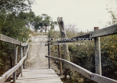 Eltham District Historical Society Inc
Colour Print, David Taylor, Footbridge over the Diamond Creek, Dalton Street Lane, Eltham. View heading west towards Bell Street, c.1976
... The footbridge over the creek was regularly subjected to damage or washed away during floods. A more substantive and flood resistant footbridge has since been erected. ...The footbridge over the creek was regularly subjected to damage or washed away during floods. A more substantive and flood resistant footbridge has since been erected. ...The laneway past Skipper's house, an extension of Dalton Street on the western side of Main Road, has long been a regular route for Eltham High School students heading to and from school. Its present day name is Wingrove Park Trail. The footbridge over the creek was regularly subjected to damage or washed away during floods. A more substantive and flood resistant footbridge has since been erected. david taylor collection, eltham, wingrove park trail, dalton street lane, dalton street footbridge -
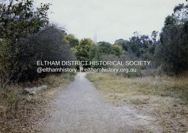 Eltham District Historical Society Inc
Colour Print, David Taylor, Dalton Street Lane, Eltham, c.1976
... The footbridge over the creek was regularly subjected to damage or washed away during floods. A more substantive and flood resistant footbridge has since been erected. ...The footbridge over the creek was regularly subjected to damage or washed away during floods. A more substantive and flood resistant footbridge has since been erected. ...The laneway past Skipper's house, an extension of Dalton Street on the western side of Main Road, has long been a regular route for Eltham High School students heading to and from school. Its present day name is Wingrove Park Trail. The footbridge over the creek was regularly subjected to damage or washed away during floods. A more substantive and flood resistant footbridge has since been erected. david taylor collection, eltham, wingrove park trail, dalton street lane, dalton street footbridge -
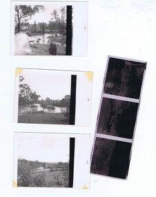 Greensborough Historical Society
Photographs and Letter, Greensborough 1960s, 1960s
... Taken during a flood in the late 1960s, showing parts of both old and new bridge across the Plenty River, kiosk and Fitton house....Greensborough Historical Society 34A Glenauburn Road Lower Plenty Lower Plenty melbourne Taken during a flood in the late 1960s, showing parts of both old and new bridge across the Plenty River, kiosk and Fitton house. greensborough plenty river greensborough fitton family Three photographs, with negatives and covering letter from Tony Fitton, with handwritten descriptive letter Greensborough 1960s Photographs and Letter ...Taken during a flood in the late 1960s, showing parts of both old and new bridge across the Plenty River, kiosk and Fitton house.Three photographs, with negatives and covering letter from Tony Fitton, with handwritten descriptive lettergreensborough, plenty river greensborough, fitton family -
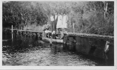 Halls Gap & Grampians Historical Society
Photograph - B/W, C 1933
... The photo shows the Wannon River in flood. Augustus (Gus) Knight built the footbridge. ...Halls Gap & Grampians Historical Society Centennial Hall 117-119 Grampians Road Halls Gap grampians The photo shows the Wannon River in flood. Augustus (Gus) Knight built the footbridge. ...The photo shows the Wannon River in flood. Augustus (Gus) Knight built the footbridge. The boat was constructed using kerosene tins or honey tins.Photo shows five adults, four standing and one squatting, on a foot bridge. There are four children in front of them in a boat.structures, bridges -
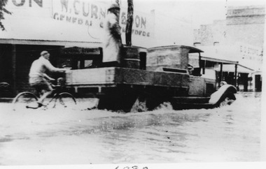 Charlton Golden Grains Museum Inc
Photograph
... Flooded High Street with Ute driving through. ...Charlton High Street W. Curnow & Son Floods Black and white photograph unframed. ...Flooded High Street with Ute driving through. A person on a bike holds onto the Ute tray. The store in the background is W. Curnow and sons. Black and white photograph unframed.charlton, high street, w. curnow & son, floods -
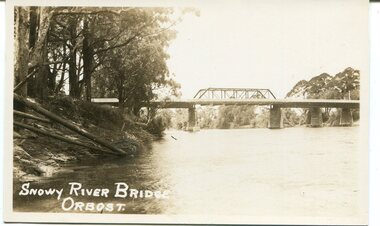
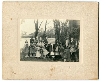 Orbost & District Historical Society
black and white photograph, 1920s
... The bridge shown in the background was built in the 1920s as a road and rail bridge, and was partly washed away by flood waters in 1934. There is no known history of this item....Orbost & District Historical Society Ruskin Street Orbost gippsland The bridge shown in the background was built in the 1920s as a road and rail bridge, and was partly washed away by flood waters in 1934. There is no known history of this item. ...The bridge shown in the background was built in the 1920s as a road and rail bridge, and was partly washed away by flood waters in 1934. There is no known history of this item.This photograph is a contemporary record of rural life in Orbost in the early 20th century.A black / white photograph of a group of young girls dressed up and posing on the banks of a river. On the left hand side of the photograph is an older man and on the right is an older lady. In the background is a bridge - the first Snowy River bridge. The photograph is on a cream coloured buff card. orbost snowy-river -
 Clunes Museum
Document, TALBOT - CLUNES SHIRE, MUNICIPAL EMERGENCY MANAGEMENT PLAN - SHIRE OF TALBOT AND CLUNES (DRAFT)
... THIS PLAN (PERHAPS A DRAFT) WAS PREPARED AS A DISASTER , AND LATER EMERGENCY PLAN FOR THE SHIRE OF TALBOT / CLUNES IN THE EVENT OF A DISASTER, SUCH AS FIRE, FLOODS OR DESTRUCTION OF BUILDINGS...Clunes Museum 36 Fraser Street enter building through Collins Place Clunes goldfields THIS PLAN (PERHAPS A DRAFT) WAS PREPARED AS A DISASTER , AND LATER EMERGENCY PLAN FOR THE SHIRE OF TALBOT / CLUNES IN THE EVENT OF A DISASTER, SUCH AS FIRE, FLOODS OR DESTRUCTION OF BUILDINGS local history government local government council essential services THIS PLAN HAS BEEN PREPARED AT THE DIRECTION OF THE COUNCIL OF THE SHIRE OF TALBOT & CLUNES... ...THIS PLAN HAS BEEN PREPARED AT THE DIRECTION OF THE COUNCIL OF THE SHIRE OF TALBOT & CLUNES...DOCUMENTS COLLATED IN A GREEN PLASTIC BINDER WITH A CLEAR PLASTIC COVER (UNDATED)non-fictionTHIS PLAN HAS BEEN PREPARED AT THE DIRECTION OF THE COUNCIL OF THE SHIRE OF TALBOT & CLUNES...local history, government, local government, council, essential services -
 Port Fairy Historical Society Museum and Archives
Photograph
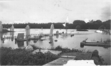
... flood...1946 was the year of the biggest flood experienced in Port Fairy. This photograph shows evidence of the inundation at the Port Fairy Cemetery situated at the West of the town...Port Fairy Historical Society Museum and Archives 30 Gipps Street Port Fairy great-ocean-road 1946 was the year of the biggest flood experienced in Port Fairy. This photograph shows evidence of the inundation at the Port Fairy Cemetery situated at the West of the town flood river 1946 headstone Black and white photograph of headstones surrounded by water Photograph Photograph ...1946 was the year of the biggest flood experienced in Port Fairy. This photograph shows evidence of the inundation at the Port Fairy Cemetery situated at the West of the townBlack and white photograph of headstones surrounded by waterflood, river, 1946, headstone -
 Wonga Park Community Cottage History Group
Newspaper (Item) - Photocopy Newspaper Cutting, Brushy Creek Catchment Ringwood Mail 15/10/1980
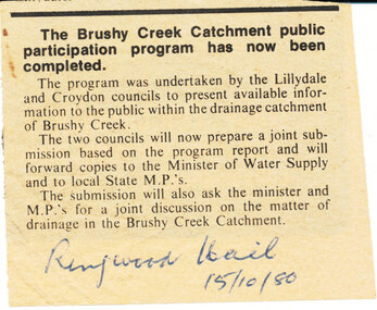
... Discussion by City of Croydon and Shire of Lillydale re matter of drainage in Brushy Creek Catchment later resulting in flood retainment scheme and levy...Wonga Park Community Cottage History Group Unit 1, 9 – 13 Old Yarra Road Wonga Park melbourne Discussion by City of Croydon and Shire of Lillydale re matter of drainage in Brushy Creek Catchment later resulting in flood retainment scheme and levy Newspaper cutting Brushy Creek Catchment Ringwood Mail 15/10/1980 Newspaper Photocopy Newspaper Cutting ...Discussion by City of Croydon and Shire of Lillydale re matter of drainage in Brushy Creek Catchment later resulting in flood retainment scheme and levy -
 Orbost & District Historical Society
black and white photograph, 1971
... It was severely battered by floods during its life. and after the devastating 1971 floods was eventually replaced by the current bridge in 1975. ...It was severely battered by floods during its life. and after the devastating 1971 floods was eventually replaced by the current bridge in 1975. ...This photograph shows the second major bridge across the Snowy River at Orbost. The current Snowy River bridge is the fourth to provide a crossing to the township of Orbost. The first, in 1891, lasted just two years before it succumbed to flood waters. The bridge in this photograph was built in the 1920s as a road and rail bridge, and was again partly washed away by flood waters in 1934. After the end of the first World War the Victorian Railways considered an extension of the railhead across the river at Orbost, and in 1922 a new timber and steel girder structure, a joint Country Roads Board — Victorian Railways venture, was built and completed at a cost of £41,000 (the steel girders came from the Flinders Street viaduct reconstruction). Subsequently it was decided not to take the railway across the river, and the bridge was only used by road traffic. It was severely battered by floods during its life. and after the devastating 1971 floods was eventually replaced by the current bridge in 1975. (info from Newletter 54N by John Phillips)This is a pictorial record of the flood damage in 1971 when part of the Snowy River Bridge was washed away.A black / white photograph of a bridge which has been damaged by floodwaters. It shows one end has been washed away.orbost-snowy-river-bridge-1971 floods-orbost-1971 -
 Bendigo Historical Society Inc.
Newspaper - JENNY FOLEY COLLECTION: FLOODED
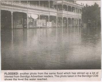
... Bendigo Advertiser ''The way we were'' from 2003. Flooded: another photo from the same flood which has stirred up a lot of interest from Bendigo Advertiser readers. ...Newspaper JENNY FOLEY COLLECTION: FLOODED ...Bendigo Advertiser ''The way we were'' from 2003. Flooded: another photo from the same flood which has stirred up a lot of interest from Bendigo Advertiser readers. This photo was taken in the Bendigo CBD shows the level the water reached. The Way we were picture confusion: the way we were picture in the Bendigo Advertiser on February 5 is in fact not Bendigo at all. I believe the picture taken is of Rochester, Victoria. The two main buildings pictured are the Shamrock hotel and the Commercial hotel and next to that hidden behind the tree is the old Westpac building. T. Parsons, the name in the photo, used to be a clothing merchant in Rochester. Written by Brian Leahy, Rochester. The clip is in a folder.newspaper, bendigo advertiser, the way we were -
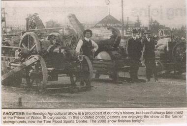 Bendigo Historical Society Inc.
Newspaper - JENNY FOLEY COLLECTION: SHOWTIME
... In this undated photo, patrons are enjoying the show at the former showgrounds, now the Tom Flood Sports Centre. The clip is in a folder....In this undated photo, patrons are enjoying the show at the former showgrounds, now the Tom Flood Sports Centre. The clip is in a folder. ...BHS CollectionBendigo Advertiser '' The way we were'' from 2002. Showtime: the Bendigo Agricultural Show is a proud part of our city's history, but hasn't always been held at the Princes of Wales Showgrounds. In this undated photo, patrons are enjoying the show at the former showgrounds, now the Tom Flood Sports Centre. The clip is in a folder.newspaper, bendigo advertiser, the way we were -
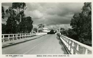 Charlton Golden Grains Museum Inc
Photograph, Bridge over Avoca River
... Bridge over the Avoca River approaching Charlton Township. Flood waters can be seen through the railings. ...Bridge over Avoca River Charlton Vic. 3525 Bridge over the Avoca River approaching Charlton Township. Flood waters can be seen through the railings. ...Bridge over the Avoca River approaching Charlton Township. Flood waters can be seen through the railings. C1956-7. New bridge built in 1923 for CRB by contractor H.B. Irwin as part of the road upgrade to highway standard. Named Calder Highway in honour of first chairman of Country Roads Board.The Rose Series P.3423. Bridge over Avoca River Charlton Vic. 3525 -
 Orbost & District Historical Society
black and white photograph, first half 20th century
... It was replaced in 1976 by the present bridge after several major floods....It was replaced in 1976 by the present bridge after several major floods. This bridge was replaced in 1976 after several major floods. ...This is a photograph of the second Snowy River Bridge at Orbost. The section in the central span could have been built after flood damage. This bridge over the Snowy River was opened on July 4 1922. It was constructed in 1922 alongside the previous suspension bridge. Its building was a combined effort of the Victorian Railways and the Country Roads Board at a cost of 35,000 pounds. It was replaced in 1976 by the present bridge after several major floods.This bridge was replaced in 1976 after several major floods.A black / white photograph / postcard of a bridge over a river. It has what looks like a bo girder in the central section. On the left is the river bank.on front bottom left - "SNOWY RIVER BRIDGE"orbost snowy-river-bridge transport-bridge -
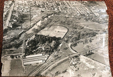 University of Melbourne, Burnley Campus Archives
Photograph - Black and white print, Airspy, Aerial View of Burnley Campus c. 1930, c. 1930
... Taken before the Boulevard was built, and probably before the flood of 1934. Therefore probably 1929-1934. ...University of Melbourne, Burnley Campus Archives 500 Yarra Boulevard Richmond melbourne Taken before the Boulevard was built, and probably before the flood of 1934. Therefore probably 1929-1934. ...Taken before the Boulevard was built, and probably before the flood of 1934. Therefore probably 1929-1934. Information provided by TH Kneen and EB LittlejohnColour photograph of black and white photograph. Photograph of Burnley Campus and large area of surrounding suburbs of Hawthorn and Toorak. It shows the Carter Oval, later modified, the Plant Research Institute (built 1929) and the Box Thorn Hedge (Lycium ferrocissimum).burnley campus, suburbs, hawthorn, toorak, carter oval, plant research institute, boxthorn hedge, lycium ferrocissimum -
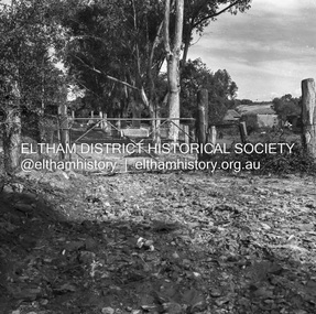 Eltham District Historical Society Inc
Negative - Photograph, J.A. McDonald, Eltham, Haldane Road, Mar. 1961
... The entrance gate on Banoon Road is located at the bottom of the hill opposite Haldane Road. The flooding issues were regularly reported to Council following heavy rain. ...The entrance gate on Banoon Road is located at the bottom of the hill opposite Haldane Road. The flooding issues were regularly reported to Council following heavy rain. ...Dr Donald Thomson's gate and entrance to his property 'Worlingworth' after flooding in March 1961 "Worlingworth", Eltham, was the home of noted anthropologist the late Professor Donald Thomson and his wife Dorita. The entrance gate on Banoon Road is located at the bottom of the hill opposite Haldane Road. The flooding issues were regularly reported to Council following heavy rain. Google Street View Feb 2014 https://goo.gl/maps/SGjsJAAEdjQXgo5V9Record of various Shire of Eltham infrastructure works undertaken during the period of 1952-1962 involving bridge and road reconstruction projects, sometimes with Eltham Shire Council Project Reference numbers quoted. It was during this period that a number of significant improvements were made to roads and new bridges constructed within the shire that remain in place as of present day (2022). In many situations, the photos provide a tangible visible record of infrastructure that existed throughout the early days of the Shire. The album was put together by or under the direction of the Shire Engineer, J.A. McDonald.infrastructure, shire of eltham, 1961-03, flood damage, haldane road, prof donald thomson, worlingworth -
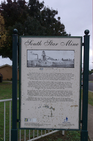 Ballarat Heritage Services
Photograph - Photograph - Colour, Corner of Vickers Street and Albert Street, Sebastopol, 2020, 07/04/2020
... The South Star Mine commenced operations in the 1880s and worke the quartz laods after the great floods of 1875 forced the closure of most alluvial mines. ...Ballarat Heritage Services PO Box 2209 Bakery Hill Post Office goldfields The South Star Mine commenced operations in the 1880s and worke the quartz laods after the great floods of 1875 forced the closure of most alluvial mines. ...The South Star Mine commenced operations in the 1880s and worke the quartz laods after the great floods of 1875 forced the closure of most alluvial mines. The South Star Mine sunk its first shaft in 1886, but broke into old alluvial workings and had to be abandoned because of flooding. The second shaft commenced in 1887, and was the deepest eer sunk in the Ballarat district, reaching 956 metres. 180 men worked three shifts each day.Colour photograph of the site of the South Star Mine in Sebastopol. sebastopol, albert street, south star mine, mining -
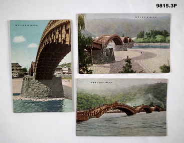 Bendigo Military Museum
Postcard - POSTCARD, JAPAN, SHUEIDO
... Colour postcard featuring three spans of a wooden bridge. River in flood. Caption in Japanese....Colour postcard featuring three spans of a wooden bridge. River in flood. Caption in Japanese. Postcard POSTCARD, JAPAN SHUEIDO ...Part of the Bennetts Collection. See Catalogue No. 9726P for details of service for "Alva Marie Bennetts".1. Colour postcard featuring a span of a wooden bridge. Stone pillar supporting span. Caption in Japanese. 2. Colour postcard featuring a view of four spans of a wooden bridge. River visible. Caption in Japanese. 3. Colour postcard featuring three spans of a wooden bridge. River in flood. Caption in Japanese.bennetts collection, alva bennetts, postcards, japan -
 Bendigo Historical Society Inc.
Article - JOHN WILLIAMS COLLECTION: NEWSPAPER ARTICLE BENDIGO LINK TOUR CYCLING, 2000s
... Photo of the three students, Tyson McCaig, Jack Flood and Nick Crome behind a bicycle....Photo of the three students, Tyson McCaig, Jack Flood and Nick Crome behind a bicycle. Article JOHN WILLIAMS COLLECTION: NEWSPAPER ARTICLE BENDIGO LINK TOUR CYCLING ...JOHN WILLIAMS COLLECTION: Newspaper Article Bendigo Link Tour Cycling Newspaper article about Quarry Hill State School Teacher John Williams, three of his students and fathers and their links to the Herald Sun Tours. Photo of the three students, Tyson McCaig, Jack Flood and Nick Crome behind a bicycle.john williams, bendigo link tour -
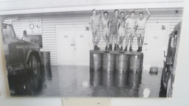 National Vietnam Veterans Museum (NVVM)
Photograph, the Wet, 5/12/1970 12:00:00 AM
... Unframed photo - Staff of air movements section No1 Operational Support Unit RAAF flooded out of thei section by monsoon/ L-R Corporal John Hawkes, Sgt Ron Phelps, Corporal Alan Rohde. 11 Movement Control Group, Royal Australian Engineers. ...National Vietnam Veterans Museum (NVVM) 25 Veterans Drive Newhaven phillip-island-and-the-bass-coast Monsoon Floods No1 Operational Support Unit RAAF Air Movements Section Vung Tau AWM VN70-57-1 (2) Unframed photo - Staff of air movements section No1 Operational Support Unit RAAF flooded out of thei section by monsoon/ L-R Corporal John Hawkes, Sgt Ron Phelps, Corporal Alan Rohde. 11 Movement Control Group, Royal Australian Engineers. ...Unframed photo - Staff of air movements section No1 Operational Support Unit RAAF flooded out of thei section by monsoon/ L-R Corporal John Hawkes, Sgt Ron Phelps, Corporal Alan Rohde. 11 Movement Control Group, Royal Australian Engineers. Leading Aircraftman Paul DisherAWM VN70-57-1 (2)monsoon floods, no1 operational support unit raaf, air movements section, vung tau -
Clunes Museum
Document - CORRESPONDENCE, 22/07/1971
... PRYOR, SHIRE SECRETARY TALBOT AND CLUNES SHIRE, TALBOT TO INSTALL TEMPORARY LIGHTING AND FLOOD LIGHTING FOR THE TOWN HALL BUTLDING DURING THE "BACK TO" EVENT ...PRYOR, SHIRE SECRETARY TALBOT AND CLUNES SHIRE, TALBOT TO INSTALL TEMPORARY LIGHTING AND FLOOD LIGHTING FOR THE TOWN HALL BUTLDING DURING THE "BACK TO" EVENT Document CORRESPONDENCE ...TYPED LETTER DATED JULY 22ND 1971 FROM JEAN PEART HON. SEC. OF THE BACK TO CLUNES COMMITTEE 1972. REQUESTING PERMISSION FROM MR. R. PRYOR, SHIRE SECRETARY TALBOT AND CLUNES SHIRE, TALBOT TO INSTALL TEMPORARY LIGHTING AND FLOOD LIGHTING FOR THE TOWN HALL BUTLDING DURING THE "BACK TO" EVENT HANDWRITTEN IN PENCIL "Tool McLennan Write to S.E.C. illegible" local history, document, letters, events and celebrations, back to clunes -
 Greensborough Historical Society
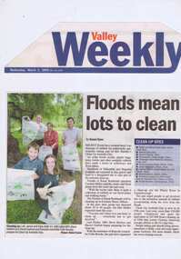
Newspaper Clipping - Digital Image, Barak Bushland Reserve - Floods mean a lot to clean, 02/03/2005
... Receding flood water levels have revealed much rubbish. ...Barak Bushland Reserve - Floods mean a lot to clean Newspaper Clipping - Digital Image ...Receding flood water levels have revealed much rubbish. Clean Up Australia day volunteers work throughout Banyule and Nillumbik to collect the rubbish.Newspaper clipping, black and white text and colour image.clean up australia day, plenty river -
 Charlton Golden Grains Museum Inc
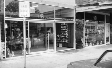
Photograph
... After remodelling in 2010, the shop was inundated with a metre of water during the January 2011 floods. During the floods, the chemist filled prescriptions from his home on Clifton Hill....After remodelling in 2010, the shop was inundated with a metre of water during the January 2011 floods. During the floods, the chemist filled prescriptions from his home on Clifton Hill. ...Originally Kenny’s Drapery store, which closed in 1974, the shop was renovated and re-opened as a pharmacy. Later owned by Mr Russell English, the pharmacy was refitted and combined with the Morton Chemist shop. Russell English sold the pharmacy in 2007, having run the business for 33 years. After remodelling in 2010, the shop was inundated with a metre of water during the January 2011 floods. During the floods, the chemist filled prescriptions from his home on Clifton Hill.Black and white photograph with white border.business, charlton, charlton pharmacy -
 Orbost & District Historical Society
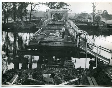
black and white photographs, February 17 1971
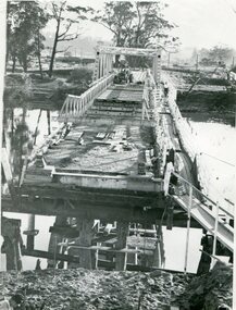
... They worked late into the night under flood lights to ensure the link from the Orbost township to the Princes Freeway would be open to traffic as soon as possible....They worked late into the night under flood lights to ensure the link from the Orbost township to the Princes Freeway would be open to traffic as soon as possible. ...After the damage from the February 1971 floods at Orbost when the abutment to the Snowy River road bridge was washed away a Bailey bridge, portable, pre-fabricated, truss bridge, was put into place to ensure town access, the C.R.B. rebuilt the approach to the bridge driving new piles and constructing the Bailey bridge. They worked late into the night under flood lights to ensure the link from the Orbost township to the Princes Freeway would be open to traffic as soon as possible.These photographs are pictorial records of a significant event in the history of Orbost.Three black / white photographs of a Bailey bridge being erected across a river. 3245.1 and 3245.2 are the same. bailey-bridge orbost-snowy-river-bridge bridge-orbost -
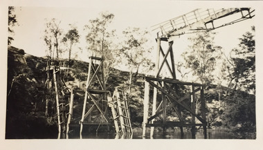
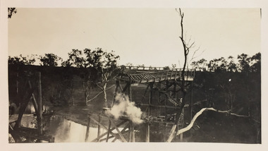
 Kew Historical Society Inc
Photograph - Demolishing the Zig-Zag Bridge, 1929
... The wooden bridge was constructed in the 1870s and lasted through numerous floods until its destruction in 1929. A horizontal structure, the walkway was reached via a wooden staircase on the Kew bank of the river. ...This is a photo of the bridge showing the level of destruction caused by the initial damage from the flood and subsequent dismantling of the horizontal struts and walkway, prior to to its destruction by fire. ...Henry Beater Christian (1886-1962) , was a descendant of one of the earliest settler families in Kew. Employed at the Kew Asylum as a 'public servant', he was a skilled amateur photographer, photographing numerous scenes in Kew and on his travels around Victoria. The majority of his photographs date from 1916 to 1929. His finest photographs are housed in two photograph albums. Rare photograph of the demolition of the Zig-Zag Bridge linking the two asylums on either side of the Yarra River.Digital copy of a photograph from page 16 of the 47-page photograph album containing 261 gelatinous silver images, loaned by Diane Washfold with permission given to digitise and hold a copy in our collection. The Zig-Zag Bridge linked the grounds of the Yarra Bend and Kew Asylums. The wooden bridge was constructed in the 1870s and lasted through numerous floods until its destruction in 1929. A horizontal structure, the walkway was reached via a wooden staircase on the Kew bank of the river. The steps were required due to the different levels of the banks on this stretch of the river. This is a photo of the bridge showing the level of destruction caused by the initial damage from the flood and subsequent dismantling of the horizontal struts and walkway, prior to to its destruction by fire."Demolishing Zig-Zag / 6. 1929"henry beater christian (1886-1962), landscape photography, kew (vic.) — yarra river, christian-washfold collection, photograph albums, zig-zag bridge -
 Kew Historical Society Inc
Photograph - Demolishing the Zig-Zag Bridge, 1929
... The wooden bridge was constructed in the 1870s and lasted through numerous floods until its destruction in 1929. A horizontal structure, the walkway was reached via a wooden staircase on the Kew bank of the river. ...The wooden bridge was constructed in the 1870s and lasted through numerous floods until its destruction in 1929. A horizontal structure, the walkway was reached via a wooden staircase on the Kew bank of the river. ...Henry Beater Christian (1886-1962) , was a descendant of one of the earliest settler families in Kew. Employed at the Kew Asylum as a 'public servant', he was a skilled amateur photographer, photographing numerous scenes in Kew and on his travels around Victoria. The majority of his photographs date from 1916 to 1929. His finest photographs are housed in two photograph albums. Rare photograph of the demolition of the Zig-Zag Bridge linking the two asylums on either side of the Yarra River.Digital copy of a photograph from page 16 of the 47-page photograph album containing 261 gelatinous silver images, loaned by Diane Washfold with permission given to digitise and hold a copy in our collection. The Zig-Zag Bridge linked the grounds of the Yarra Bend and Kew Asylums. The wooden bridge was constructed in the 1870s and lasted through numerous floods until its destruction in 1929. A horizontal structure, the walkway was reached via a wooden staircase on the Kew bank of the river. The steps were required due to the different levels of the banks on this stretch of the river. This is a closeup view of the bridge showing the level of destruction caused by the initial damage from the flood and subsequent dismantling of the horizontal struts and walkway, prior to to its destruction by fire."Demolishing Zig-Zag / 6. 1929"henry beater christian (1886-1962), landscape photography, kew (vic.) — yarra river, christian-washfold collection, photograph albums, zig-zag bridge -
 Kew Historical Society Inc
Photograph - Demolishing the Zig-Zag Bridge, 1929
... The wooden bridge was constructed in the 1870s and lasted through numerous floods until its destruction in 1929. A horizontal structure, the walkway was reached via a wooden staircase on the Kew bank of the river. ...The wooden bridge was constructed in the 1870s and lasted through numerous floods until its destruction in 1929. A horizontal structure, the walkway was reached via a wooden staircase on the Kew bank of the river. ...Henry Beater Christian (1886-1962) , was a descendant of one of the earliest settler families in Kew. Employed at the Kew Asylum as a 'public servant', he was a skilled amateur photographer, photographing numerous scenes in Kew and on his travels around Victoria. The majority of his photographs date from 1916 to 1929. His finest photographs are housed in two photograph albums. Rare photograph of the demolition of the Zig-Zag Bridge linking the two asylums on either side of the Yarra River.Digital copy of a photograph from page 16 of the 47-page photograph album containing 261 gelatinous silver images, loaned by Diane Washfold with permission given to digitise and hold a copy in our collection. The Zig-Zag Bridge linked the grounds of the Yarra Bend and Kew Asylums. The wooden bridge was constructed in the 1870s and lasted through numerous floods until its destruction in 1929. A horizontal structure, the walkway was reached via a wooden staircase on the Kew bank of the river. The steps were required due to the different levels of the banks on this stretch of the river. This is a view of the bridge showing the level of destruction caused by the initial damage from the flood, the subsequent dismantling of the horizontal struts and walkway, and the setting on fire of the remaining structure."Demolishing Zig-Zag / 6. 1929"henry beater christian (1886-1962), landscape photography, kew (vic.) — yarra river, christian-washfold collection, photograph albums, zig-zag bridge