Showing 1893 items
matching floods
-
 Eltham District Historical Society Inc
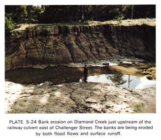
Work on paper (Sub-Item) - Photograph, Bank erosion on Diamond Creek just upstream of the railway culvert east of Challenger Street
Colour photograph of bank erosion on Diamond Creek just upstream of the railway culvert east of Challenger Street in Diamond Creek township. The banks are eroded by both flood flows and surface runoffeltham, drain, diamond creek, erosion, challenger street -
 Halls Gap & Grampians Historical Society
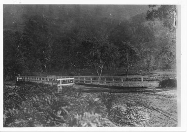
Photograph, C 1911
This is the second Delley''s Bridge. A new and more substantial bridge was built in 1911, only to be badly damaged in a 1917 flood. The collapsed western end was rebuilt, this time supported by concrete pillars.The photo shows a dirt road crossing a creek via a wooden bridge. A woman is driving a horse and buggy onto the far end of the bridge. There are ferns in the foreground and trees in the background.access routes, roads, structures, bridges -
 Lake Bolac & District Historical Society
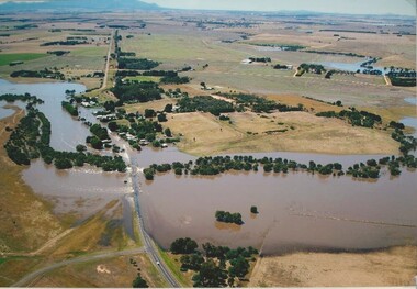
Colour photograph, Wickliffe Flood, Jan .2011
Wickliffe, the flooded Hopkins River flowing from left to right, both under and over the bridge, showing the inundated Glenelg Highway and township. January, 2011. Photograph courtesy James Davidson.wickliffe, hopkins river, flood, glenelg highway -
 Lake Bolac & District Historical Society
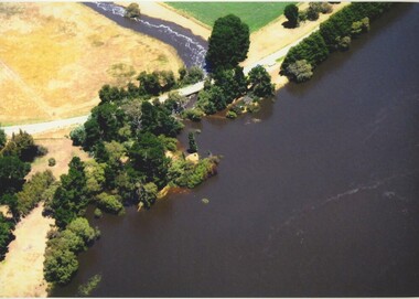
Colour photograph, Jan. 2011 Flood, Lake Bolac and Salt Creek
Jan. 2011 Flood. Debouchment from Lake Bolac into Salt Creek through the natural overflow (centre) and the channel (front left) dug in the 1920's. Photograph courtesy Bill Sharp.lake bolac, salt creek, flood, sharp. -
![View on the Upper Buckland River / [by] Nicholas Caire, circa 1876](/media/collectors/550653872162f11fb04854aa/items/57830fc0d0cdd1176c450fda/item-media/57831013d0cdd1176c454bda/item-fit-380x285.jpg) Kew Historical Society Inc
Kew Historical Society IncPhotograph, Anglo-Australasian Photographic Company, View on the Upper Buckland River, c. 1876
Nicholas Caire was born on Guernsey in the Channel Islands in 1837. He arrived in Adelaide with his parents in about 1860. In 1867, following photographic journeys in Gippsland, he opened a studio in Adelaide. From 1870 to 1876 he lived and worked in Talbot in Central Victoria. In 1876 he purchased T. F. Chuck's studios in the Royal Arcade Melbourne. In 1885, following the introduction of dry plate photography, he began a series of landscape series, which were commercially successful. As a photographer, he travelled extensively through Victoria, photographing places few of his contemporaries had previously seen. He died in 1918. Reference: Jack Cato, 'Caire, Nicholas John (1837–1918)', Australian Dictionary of Biography.An original, rare photograph from the series 'Views of Victoria: General Series' by the photographer, Nicholas Caire (1837-1918). The series of 60 photographs that comprise the series was issued c. 1876 and reinforced a neo-Romantic view of the Australian landscape to which a growing nationalist movement would respond. Nicholas Caire was active as a photographer in Australia from 1858 until his death in 1918. His vision of the Australian bush and pioneer life had a counterpart in the works of Henry Lawson and other nationalist poets, authors and painters.‘View on the upper Buckland River’ : Views of Victoria (General Series) No.46 : Albumen silver photograph | Photo on card with Title and Description on reverse | Mounted 24 x 30 cm; Photo 12 x 17 cm.On Reverse: ‘The Buckland River is situated near the western extremity of the Australian Alps, and forms one of the sources of the Ovens River. Its watercourse is very shallow, except in flood time. Our illustration is taken on the upper portion of the River, near Reeve’s dam.’nicholas caire (1837-1918), buckland river (vic), landscape photography - victoria -
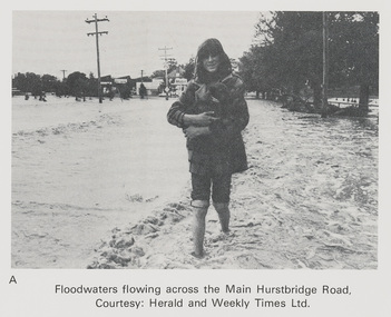 Eltham District Historical Society Inc
Work on paper (Sub-Item) - Photograph, Floodwaters flowing across Main Hurstbridge Road, Diamond Creek Township, 8 April 1977
Black and white photograph of young woman walking through floodwaters, possibly carrying an animal. The Diamond Creek in flood at Diamond Creek township, 8 April 1977 Herald and Weekly Times collectionflood, diamond creek, flooding, herald and weekly times, rescue -
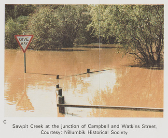 Eltham District Historical Society Inc
Work on paper (Sub-Item) - Photograph, Sawpit Creek at the junction of Campbell and Watkins Street, Diamond Creek Township, 8 April 1977
Colour photograph. Sawpit Creek at the junction of Campbell and Watkins Street, Diamond Creek Township. The Diamond Creek in flood at Diamond Creek township, 8 April 1977 Nillumbik Historical Society collectionflood, diamond creek, flooding, nillumbik historical society, give way, sawpit creek, campbell street, watkins street -
 Lakes Entrance Regional Historical Society (operating as Lakes Entrance History Centre & Museum)
Photograph, 1900 c
The Mitchell River Weir was commenced in 1900 work continued until almost completed, Foundation stone laid in March 1893 but the extensive flood damage in December 1893 ended the high hopes of the planners.Sepia toned photograph of weir on the Mitchell River at Glenaladale Victoriatopography, waterways -
 Kew Historical Society Inc
Photograph, Chipperfield's Boat House & Floating Pontoon, c.1939
Several boathouses were built in Kew and Fairfield in the late 19th and early 20th centuries. They included Chipperfield’s ‘Moorings’ and floating pontoon. The substantial two-storey house was named the Moorings, and incorporated an upper storey residence. The Moorings was almost washed away in the 1916 floods, and in 1934 almost totally submerged when the Yarra River rose 26 feet in 14 hours. Following the 1934 flood, the house was restored. The floating pontoon, sometimes referred to as a ‘kiosk’ or ‘canteen’, was used to store canoes. Both were removed in 1972 for the construction of the Eastern Freeway.This work forms part of the collection assembled by the historian Dorothy Rogers, that was donated to the Kew Historical Society by her son John Rogers in 2015. The manuscripts, photographs, maps, and documents were sourced by her from both family and local collections or produced as references for her print publications. Many were directly used by Rogers in writing ‘Lovely Old Homes of Kew’ (1961) and 'A History of Kew' (1973), or the numerous articles on local history that she produced for suburban newspapers. Most of the photographs in the collection include detailed annotations in her hand. The Rogers Collection provides a comprehensive insight into the working habits of a historian in the 1960s and 1970s. Together it forms the largest privately-donated collection within the archives of the Kew Historical Society.Chipperfield's Floating Canteen (also known as the pontoon) on the Yarra River. at North Kew The children wading in the river are believed to be the three sons of Dorothy Rogers."Chipperfield's Floating Canteen & house in background. At extreme right - observe channel where Connors Creek flows in."chipperfield's boat house, river yarra, dorothy rogers, floods 1916, 1934 -
 Eltham District Historical Society Inc
Negative - Photograph, Construction of the new concrete bridge over the Diamond Creek on Main Road, Eltham, c.May 1926
Construction of the new concrete bridge over the Diamond Creek on Main Road, Eltham, c.May 1926. Viewed from present day Wingrove Park. The original long suspension bridge over the Diamond Creek on Main Road at Eltham collapsed during flooding of the Diamond Creek on October 13 and 14, 1923. The original bridge was built around 1840 for the coach road when Cobb & Co.'s coach was the only conveyance between Eltham and Melbourne. Widespread damage was done in Melbourne and surrounding areas by floods resulting from the overflow of the Yarra at many points along its banks. A temporary bridge rigged up was severely damaged by the flooding of the creek and was closed to vehicular traffic in April 1924. A new concrete bridge was constructed to replace it and by May 1926 all the concrete piles and abutments had been completed. The bridge was finally completed and opened for traffic in September 1926, almost three years after it initially collapsed.This photo forms part of a collection of photographs gathered by the Shire of Eltham for their centenary project book,"Pioneers and Painters: 100 years of the Shire of Eltham" by Alan Marshall (1971). The collection of over 500 images is held in partnership between Eltham District Historical Society and Yarra Plenty Regional Library (Eltham Library) and is now formally known as the 'The Shire of Eltham Pioneers Photograph Collection.' It is significant in being the first community sourced collection representing the places and people of the Shire's first one hundred years.Digital image 4 x 5 inch B&W Neg Print 9 x 12.5 cmshire of eltham pioneers photograph collection, eltham, eltham lower park, main road bridge, eltham south, bridge, diamond creek (creek), wingrove park, bridge construction -
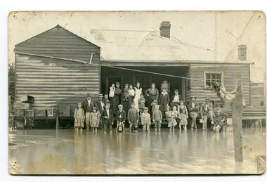 Orbost & District Historical Society
black and white photograph, poss. 1920
In the photograph are the Rice family, Billy Nixon' family and Charlie Johnston. William Nixon, son of James Nixon and Alice (Roberts) Nixon was married to Ilma Muriel (Cadwallader) Nixon on 2 Apr 1902 in Orbost. They had six children - Llewella Adele (Nixon) King, Sydney William Columbo Nixon, Arthur Harry Nixon, Jack Warton Nixon, Claudine Frances (Nixon) Taylor and Daphne Joyce (Nixon) Menz Damage estimated at £500,000 was caused by the 1934 floods in the Orbost district. This 1934 flood was devastating, destroying a section of the 1922 Orbost bridge, wrecking fences, bridges and roads, dumping silt and debris on the rich river flats and drowning cattle. Note: although this card has the date 1934 written onto the rear, the flood incident depicted most likely dates from 1920 (ref. Weekly Times, Saturday 6 March 1920 p 41 when this photo was printed).This item is a pictorial record of a flood in 1920 (ref. Weekly Times, Saturday 6 March 1920 p41). Snowy River flood are a feature of the Orbost area. These floods cover the rich agricultural land. A black / white photograph / postcard of a group of people standing in floodwaters outside a timber building. Included are young children and babies being held by women. Two boys are holding dogs in front of them.on back - "Billy Nixon's house (now Downys 1991)"orbost - floods - nixon - 1920 -
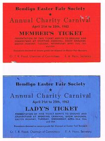 Bendigo Historical Society Inc.
Document - DOCUMENT -BENDIGO EASTER FAIR SOCIETY TICKETS, 09/11/1903
Two Bendigo Easter Fair Society Annual Charity Carnival Tickets April 21st to 25th, 1962. The red one is a Member's Ticket and the blue one is a Lady's Ticket. Tickets admit bearer to ground and Grandstand at Sporting Carnival, Show Grounds on Easter Monday, Tuesday, Wednesday, April 23rd, 24th and 25th. Cr. T. R. Flood, Chairman of Committees and E. A. Hains, Secretary.bendigo, bendigo easter fair, charity carnival, document, bendigo easter fair society tickets, annual charity carnival, cr t r flood, e a hains -
 Kew Historical Society Inc
Photograph - Yarra River, Studley Park, 1924
Henry Beater Christian (1886-1962) , was a descendant of one of the earliest settler families in Kew. Employed at the Kew Asylum as a 'public servant', he was a skilled amateur photographer, photographing numerous scenes in Kew and on his travels around Victoria. The majority of his photographs date from 1916 to 1929. His finest photographs are housed in two photograph albums. Digital copy of a photograph from page 7 of the 47-page photograph album containing 261 gelatinous silver images, loaned by Diane Washfold with permission given to digitise and hold a copy in our collection. This photograph was taken during a flood year when the Yarra encroached on the grounds of the Abbotsford Convent. In the distance, the Johnston Street Bridge separates the viewer from the industrialised landscape of Fairfield."Studley Park / Kew"henry beater christian (1886-1962), landscape photography, kew (vic.) — yarra river, christian-washfold collection, photograph albums, fairfield, kew, johnston street bridge, studley park -
 Greensborough Historical Society
Magazine, Banyule City Council, Banyule Banner February 2019, 2019_02
The Banyule Banner is published bi-monthly by Banyule City Council to advertise upcoming events in the City of Banyule and to report on past events. This edition covers Graffiti, Flood management and North East Link updateA record of events within the City of Banyule.20 pages (approx.), colour illustrations. banyule banner -
Tatura Irrigation & Wartime Camps Museum
Newspapers, Newspapers local and Victorian, 1897 to 2002
... floods ...Old NewspapersNewspapers and photocopies - Various articles from Tatura and about Tatura from 1897 to 2002.|The Southern Cross 19th Feb 1897|The Age 17th October 1854|Tatura Free Press & Rodney & Deakin Shire Advocate August 4th 1905|Tatura Guardian, Tatura Herald & Kyabram Union February 1st 1901|The Goulburn Valley Yeoman 27th April 1911|The Goulburn Valley Stock & Property Journal 22nd September 1920|The Leader Pictorial Section -Tatura Show- 28th Oct 1939|Weekly Times - Tatura Pictures- 12th December 1931|The Australasian-Tatura Coursing Club Waterloo Cup-25th July 1936|The Leader -Tatura Pictures & Australian Sheep Show with Starritt's- 8th August 1936|Weekly Times - Old Time Ball- 26th August 1959|Shepparton News - Dhurringile Boys Pipe Band- 25th April 1955|Tatura Guardian Press - Floods- 3rd March 1955|Tatura Guardian Press 2nd April 1959|Tatura Guardian Press - photocopy front page-5th July 1951|Tatura Guardian Press 13th Sept 1951|Tatura Guardian Press 13th July 1950|Tatura Guardian Press 10th November 1955|Sun Herald - photocopy extracts re Mrs J LeRoy & Whroo - 1967|Tatura Guardian Press - photocopy 2 pages- 8th September 1960|Tatura Guardian Press - Front page- 4th December 1969|Tatura Guardian Press 21st April 1966|Tatura Guardian Press 10th November 1966|Weekly Times - photocopy Lockwood Family Reunion|Shepparton News - Flood News & Pictures - 17th May 1974|Shepparton News - Flood News & Pictures - 20th May 1974|Shepparton News - Flood News & Pictures - 24th May 1974|Rodney Guardian 24th July 1974|Rodney Guardian 10th April 1974|Rodney Guardian 17th April 1974|Rodney Guardian 19th June 1974|Tatura Free Press Guardian - pages 5 - 16 - 11th October 1977|Tatura Guardian - Front Page , opening of Tatura Primary School - 1st April 1971|The Herald Sun - Woodlands Centenary and Crawford Family photos - 11th June 1971|Tatura Guardian - 2 copies- Rodney Shire Centenary - 17th June 1986|Shepparton News - Rodney Shire Centenary - 17th June 1986|Tatura Guardian - Front & Back Page - 7th January 1985|Tatura Guardian - 14th January 1986, 18th February 1986, 24th October 1986, 13th January 1987, 23rd June 1987, 23rd December 1986, 16th September 1986, 17th June 1986, 23rd January 2001, 30th January 2001, 19th February 2002|Shepparton News - 1 page about John Purdey Rodney Shire Secretary - 24th October 1986|Tatura Guardian - Front & Back Page - 10th March 1987|Tatura Guardian - pages 3 - 18 - 17th March 1987|Tatura Guardian - Front & Back Page - 2nd September 1986|Tatura Guardian - 4 pages - 19th August 1986|Tatura Guardian - Front & Back Page - 14th April 1987|Tatura Guardian - Front & Back Page - 31st August 1984|Tatura Guardian - Front & Back Page - 7th August 1984|Tatura Guardian - Front & Back Page - 14th February 1984|Tatura Guardian - Pages 3 & 4, 13& 14 - 17th May 1983|Tatura Guardian - 2 pages - 2nd July 1985|Shepparton News - Farewell to Rodney Shire Councillor John Gray as mayor - 7th November 1986|Weekly Times - 1 page of Tatura Show pictures - 26th March 1986|Tatura Guardian - Front Page 2nd October 2001|Various photocopies of Tatura papers with obituaries for Mr Peter Mactier, Miss Anne Bridget Hanlon, Mrs Catherine Kennedy, Mrs J.W. Wilson and death of Mrs Doris Simson (nee Vibert)|Rodney Shiretatura, shire of rodney, tatura agricultural show, starritt, crawford, woodlands, tatura coursing club, waterloo cup, mactier, hanlon, simson, vibert, kennedy, wilson, tatura old time ball, floods, leroy, whroo, lockwood, tatura primary school, documents, newspapers -
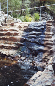 Lakes Entrance Regional Historical Society (operating as Lakes Entrance History Centre & Museum)
Photograph, 1999
Built 1942 - 43 to ensure as adequate water supply for fire fighting purposes, after the devastation of the 1939 forest fires. Used by locals as a swimming pool until flooding in the 1980's filled the weir with silt.Colour photograph of Costicks Weir, Old Colquhoun Road, Colquhoun Forest. Shows manmade dam in bush setting. Constructed by building a weir wall across a small natural gorge. Nowa Nowa Victoriavegetation -
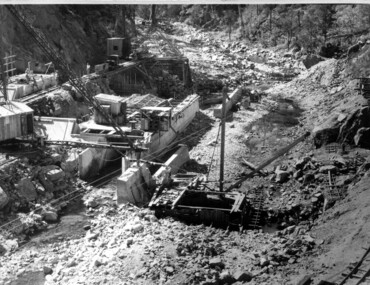 Kiewa Valley Historical Society
Photograph of Clover Dam foundations, Clover Dam Foundations, 1949
Stripping of the foundations commenced in 1948 and the first concrete in the dam was poured in May, 1949. With the suspension for the winter months of work on the High Plains, it was possible to increase the number of men, and work then proceeded at a steady pace for the remainder of the year. Some interruption was caused by a flood in September, which over topped the rockfill coffer dam. By the end of 1950 17,000 yards of material had been excavated from the foundations and 4,000 cubic yard of concrete placed. Work at Clover Dam was completed in 1953, but two bays were left open for flood emergency. The pondage was filled on the 16th August, 1954. A pictorial record of the placing of concrete foundations of Clover Dam and also shows the methods of construction used at this site in 1949.Black and white photograph taken during the construction of Clover Dam. Shows early stages of the concrete foundations, cranes and the railway line which was constructed to bring materials to the site. Handwritten in blue ink of back of photograph "Clover Dam Foundations"dam, foundations, concrete, construction -
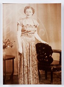 City of Greater Bendigo - Civic Collection
Photograph - Portrait, Monica Flood, Mayoress 1952 - 53, 1957 - 58, 1966 - 67, 1968 - 69, c 1950's
Prior to the election of female Councillors and Mayors in the 1960’s, the Lady Mayoress role was one of the few ways women could officially undertake civic duties. Mayoresses made important contributions to their local communities through their charity work and as ambassadors for their region on a state and federal level. They also undertook some Mayoral duties on occasions when their husband was unavailable. Monica Cecelia Murray was born in 1910 in Strathfieldsaye and married Thomas Flood in 1934. She served as Mayoress for four terms and died in 1973. Mayoress Flood was president of the St Mary's Past Pupul's Association and a patron of the Bendigo Girl Guildes. Reproduction of photographic studio portrait sitting behind oval mount.studio photography, raymond kelly, city of bendigo mayoress, city of greater bendigo portraits, city of bendigo mayor, mayoress flood, mayor t.r. flood -
Mission to Seafarers Victoria
Letter - Correspondence, 03/04/1950
The writer refers to Allan's and her own family members and is thought to be a relative; more research is needed. She also writes ".....I suppose you've heard all about the floods here, winter certainly is settling in early ....".Quinn CollectionA single page of unlined pale blue paper folded in book form to give four pages of writing (0836.a). Letter is headed Nurses Home, Alfred Hospital, Prahran and dated 3.04.1950. Matching envelope (0836.b) is addressed to M.S. Mongabarra, C/- Elder Smith & Co., Adelaide. 'Adelaide' has been crossed out and an indecipherable port, possibly Port Lincoln, has been added by a different writer and in darker ink. Envelope bears three red, two and halfpenny Australian stamps franked Melbourne. The letter commences "Dear Allan......" and is signed "Yours June". letters-from-abroad, quinn -
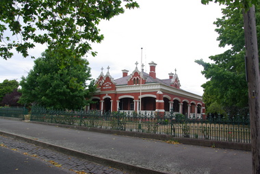 Victorian Interpretive Projects Inc.
Photograph - Colour, Clare Gervasoni, St Alipius Presbytery, Ballarat East, 07/01/2012
St Alipius Church was the first Catholic Church at Ballarat. It was initially a tent church in Humffray Street, but after flooding it was moved to Victoria Street were the current bluestone church was built. The presbytery is beside the church and houses the priests. A colour photograph in digital format showing red brick building with slate roof, behind a green iron fence. The building is St Alipius Presbytery, Victoria Street, Ballarat East. ballarat east, catholic, religion, church, st alipius', st alipius -
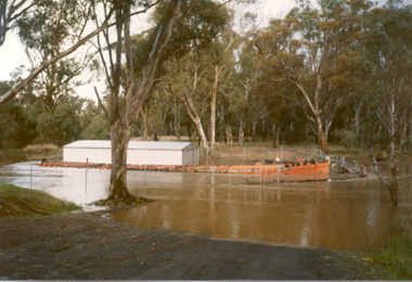 Tatura Irrigation & Wartime Camps Museum
Photograph, Paddle Steamer "Arbuthnot", 1986
Paddle Steamer "Arbuthnot", purchased by the Shire of Rodney to be restored using unemployment relief funding. Located on Goulburn River, upstream of Shepparton. Photo taken 1986 during river flooding. Now restored at Echuca.|Rodney Shire -
Bendigo Historical Society Inc.
Document - ELDORADO - THE STORY OF EL DORADO
Typed notes titled 'The Story of El Dorado' taken from the Mining & Geological Journal, dated January 1938 by D. G. Swift. Notes typed by L. G. Schilling, 13/10/69. Notes mention the disappointments, difficulties with water and the ground and floods, As well as gold they also found large quantities of tin oxide and a large variety of gemstones. A powerful jet of water was used for the mining.document, gold, eldorado, eldorado, the story of el dorado, mining & geological journal january 1938, d g swift, the argus 19/10/1855, kneebone & company, wellington party, mcevoy mine, kneebone mine, tin oxide, gemstones, united eldorado company, mining registrar, ovens gold and tin mining, eldorado extended, perserverance, great extended gold and tin mining, wellington company, mr william dunstan, united ovens gold and tin, the warrior, try again company, mcevoy disaster, cock's pioneer electric gold and tin sluicing company, mr h falsoner, cock's pioneer gold and tin mines n l company, state electricity commission, hydraulic sluicing, gold dredge, cock's eldorado company, l g schilling -
Melbourne Tram Museum
Newspaper, The Herald, "Jail protesters paint trams", 23/02/1972 12:00:00 AM
Newspaper clipping titled - “Jail protesters paint trams” The Herald, Wednesday, Feb 23, 1972 Photos and text of vandalised trams at Preston workshops 20 trams, 40 men worked for an hour to remove the signs - graffiti - . Tram services not affected. Most of the trams were at Preston for repair after flood damage last week. See TMSV Running Journal April 1972 for details of the event.trams, tramways, preston workshops, graffiti, pentridge prison, protest -
Tatura Irrigation & Wartime Camps Museum
Photograph - copy, Collivers Milk Bar, 1950
Copy of photograph of Collivers mixed business and milk bar. Conducted from 1946 - 1986. Also bus depot for Bendigo to Shepparton bus, run by Floods for many years. Also sub agent for newspaper, magazines and Sunday papers.Black and white photograph of left hand side of shop, 159 Hogan Street, Tatura and part of dwelling. Old car in drive of yard, belongs to Browns, Bakers.on back: Collivers Milk Bar 1950 -
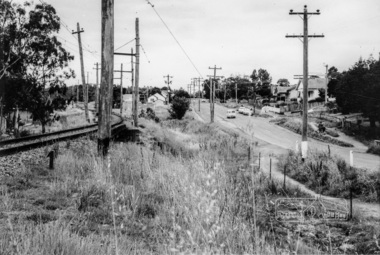 Eltham District Historical Society Inc
Photograph, Looking north along Main Road from Cecil Street intersection, Eltham, February 1968, Feb 1968
... floods ...Shows position of under road water course, which also went under railway line to the Diamond Creek and Cecil Street sign.In February 1968 an unknown person took a series of photos from the Eltham Hotel at Pitt Street heading north along Main Road through the shopping centre to just north of Elsa Court covering the length of the section of Main Road which was duplicated shortly thereafter. Shows the condition and environment of the streesscape of Main Road, Eltham immediately prior to the duplication between Pitt Street and Elsa Court through the shopping centre. Also shows a number of shops and businesses that operated at that time.Black and white photographduplication, eltham, main road, cecil street, railway line, watercourse, floods -
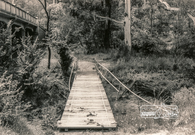 Eltham District Historical Society Inc
Photograph, Flood damage, Footbridge, Main Road, Eltham
... floods ...Black and white photographeltham, infrastructure, shire of eltham infrastructure, bridge, footbridge, main road, floods -
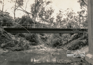 Eltham District Historical Society Inc
Photograph, Flood damage, Footbridge, Main Road, Eltham
... floods ...Black and white photographeltham, infrastructure, shire of eltham infrastructure, bridge, footbridge, main road, floods -
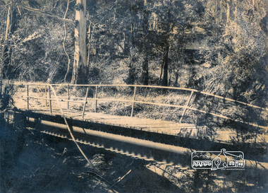 Eltham District Historical Society Inc
Photograph, Flood damage, Footbridge, Main Road, Eltham
... floods ...Black and white photographeltham, infrastructure, shire of eltham infrastructure, bridge, footbridge, main road, floods -
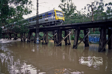 Eltham District Historical Society Inc
Photograph, Fred Mitchell, X'Trapolis Train crossing over the Railway Trestle Bridge at Eltham during Diamond Creek flood, 2005, 2005
... floods ...Digital copy of colour photographfred mitchell collection, 2005, diamond creek, electric train, eltham, floods, trestle bridge -
Merbein District Historical Society
Film, 1959 Jubilee Parade, Flood, Farm & Circus footage, 1950's
... Floods ...circus, merbein township, birthday celebrations merbein 1959, merbein jubliee celebrations, floods, paschendale avenue, keera station