Showing 17447 items
matching bay-bridge
-
 Melbourne Tram Museum
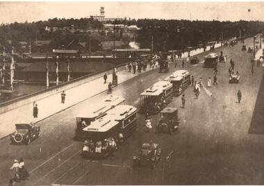
Photograph - Photograph Card, Kelly Collection, View Productions, Princes Bridge / Batman Ave tram terminus, Photo c1920
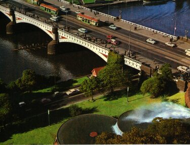
Photograph Card - folded card, blank inside of Cable Trams, motor cars, pedestrians crossing Princes Bridge over the Yarra River with the Princes Bridge / Batman Ave tram terminus with a shelter in the background. Shows five cable tram sets. Has railway signals and Government House in the view. Produced by View Productions GPO Box 1858 Sydney, from the Kelly Collection, titled "On the Princes Bridge, circa 1920, Melbourne, Victoria, Australia". Has the Publishers logo on the rear.trams, tramways, princes bridge, batman ave, swanston st, cable trams, shelters -
 Ringwood and District Historical Society
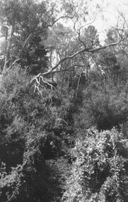
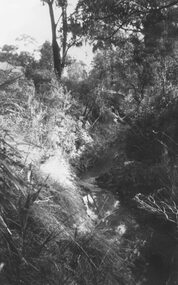
Photograph, Mullum Creek from bridge in Warrandyte Rd. Looking east, 1972
Written on backing sheet, "Mullum Creek from bridge in Warrandyte Rd. Looking east, 1972" -
 Ringwood and District Historical Society
Photograph, Mullum Creek from bridge in Warrandyte Rd. Looking east, 1973
Written on backing sheet, "Mullum Creek from bridge in Warrandyte Rd. Looking east, 1973". -
 Ringwood and District Historical Society
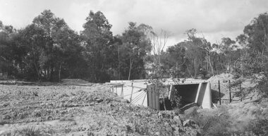
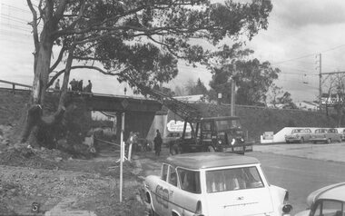
Photograph, Bridge over Mullum Creek under construction, Oliver Street. 1963
2 photographsWritten on back of photograph, "Bridge over Mullum Creek, Oliver Street. 17/11/1963" -
 Ringwood and District Historical Society
Photograph, Eastfield Road bridge just opened - looking east. Ringwood 1978
Written on back of photograph, "Late 1978. Eastfield Road bridge just opened - looking east." -
 Ringwood and District Historical Society
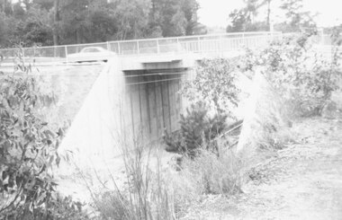
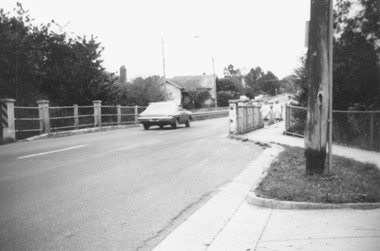
Photograph, Warrandyte Road Bridge over Mullum Mullum Creek, Ringwood 1986
Written on back of photograph, "3.8.86. Ringwood. Warrandyte Road Bridge over Mullum Mullum Creek". -
 Ringwood and District Historical Society
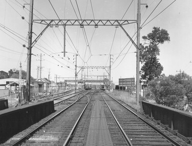
Photograph, View from Ringwood Clocktower overlooking Wantirna Road railway bridge and Thanet Street corner - Dec. 1969
Black and white photographWritten on back of photograph: "Wantirna Rd bridge. from clocktower, 1969". Thanet Street corner. -
 Ringwood and District Historical Society
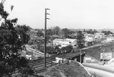
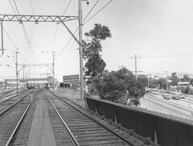
Photograph, Maroondah Highway West, Ringwood- 1965. Wantirna Road bridge widening
Black and white photograph (2 copies)Written below one photograph: "Wantirna Road railway bridge- preparing to widen underpass, 1965. -
 Ringwood and District Historical Society
Photograph, Ringwood Railway Station, 1974, viewed from bridge over Warrandyte Road in foreground, looking west
Black and White photographWritten on back of photograph, "Ringwood Railway Station, 1974. From bridge over Warrandyte Road". -
 Ringwood and District Historical Society
Photograph, Ringwood Railway Station overlooking Maroondah Hwy viewed from bridge over Warrandyte Road in foreground, 1974
Black and White photographWritten on back of photograph, "Ringwood Railway Station, 1974 from bridge over Warrandyte Road." -
 Port of Echuca
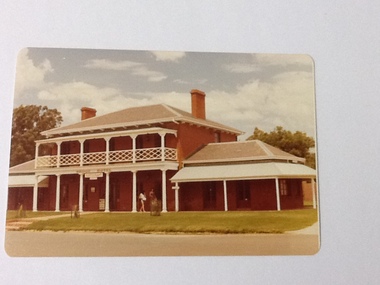
Colour Photograph, Approx.1979
The Bridge Hotel was built by Henry Hopwood, founder of Echuca. The building was in disrepair until it was bought by the Port of Echuca and renovated to be turned into part of the Port of Echuca tourist exhibits and was leased out to be run as a restaurant.The Bridge Hotel is of historical and social significance to Echuca as it was built be Echuca's founder Henry Hopwood. The hotel was situated between the 2 rivers, Murray and Campaspe, where Hopwood ran his punt business, charging people and animals to cross the rivers. The hotel accommodated a variety of paying guest from wealthy squatters to salesmen and general workers. The building was purchased by the Port of Echuca to be part of the tourist attraction. It was extensively renovated to bring it back to its former glory. The Bridge hotel played an important role in the TV series "All the Rivers Run". Colour photograph of the Bridge Hotel, Echuca, after restorations (c.1979)On front of building : Bridge Hotel / Restaurant Printed on reverse:"This paper manufactured by Kodak"bridge hotel, echuca, port of echuca, echuca, victoria -history, henry hopwood -
 Orbost & District Historical Society
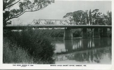
black and white photograph, Rose Stereograph Company, first half 20th century
A new bridge over the Snowy River at Orbost was opened for traffic on June 20th 1922. It was a new timber and steel girder structure, a joint Country Roads Board — Victorian Railways venture and was built and completed at a cost of £41,000 (the steel girders came from the Flinders Street viaduct reconstruction). Subsequently it was decided not to take the railway across the river, and the bridge was only ever used by road traffic. Postcards form a vital part of social and historical records for researchers. This postcard is a pictorial record of an earlier bridge across the Snowy River at Orbost.A black / white postcard photograph of a bridge over the Snowy River at Orbost.0n front - The Rose Series P1200 copyright Bridge Over Snowy River Orbost Vic.snowy-river-bridge -
 Federation University Historical Collection
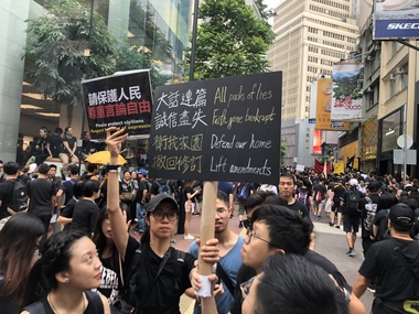
Photograph - Colour, Jarrod Watt, Crowds Gather on June 16 on the Streets of Causeway Bay, 2019, 17/06/2019
Carrie Lam, Hong Kong’s chief executive, had plenty of political support in the territory’s pro-Beijing legislature to pass a bill that would allow extraditions to mainland China. The legislators were set to begin discussing the bill in early June, and intended to vote on it just weeks later. A series of protests took place, and after a June 16 protest saw the largest turnout yet, Ms. Lam made a major concession: She postponed the bill, at least temporarily. It was an undeniable victory for the protesters — but it did little to quell the unrest. Since the bill could later be reintroduced, protesters felt they remained in danger. The police tactics to break up the demonstrations on June 12, including the use of more than 150 tear gas canisters to push protesters far away from the government office, created a new set of demands from the protesters. Now, instead of just calling for the withdrawal of the bill and Ms. Lam’s resignation, they said they wouldn’t be content unless there was an independent investigation of officers’ conduct. They also wanted the release of protesters arrested on June 12, and for the government to rescind its description of the demonstrations as a “riot,” a designation that carries legal significance. None of that has happened. Many analysts say Ms. Lam is unlikely to step down, nor would Beijing accept her resignation if she offered it. She has more wiggle room on the other demands, but has not indicated any willingness to budge. The Hong Kong Protests are a leaderless, digital movement.There is no single leader or group deciding on or steering the strategy, tactics and goals of the movement. Instead, protesters have used forums and messaging apps to decide next steps. Anyone can suggest a course of action, and others then vote on whether they support it. The most popular ideas rise to the top, and then people rally to make them happen. At its best, this structure has empowered many people to participate and have their voices heard. Protesters say it keeps them all safe by not allowing the government to target specific leaders. Their success in halting the extradition bill, which was shelved by the territory’s chief executive, speaks to the movement’s power. Despite the lack of a clear leader, protesters have shown extensive coordination at the demonstrations, having planned the specifics online beforehand. Supply stations are set up to distribute water, snacks, gloves, umbrellas and shields made of cardboard. Volunteer first aid workers wear brightly colored vests. People form assembly lines to pass supplies across long distances, with protesters communicating what they need through a series of predetermined hand signals. Anyone walking in dangerous areas without a helmet or a mask is quickly offered one. No individual can speak on behalf of the protesters, which makes negotiations difficult, if not impossible. (https://www.nytimes.com/2019/07/02/world/asia/hong-kong-protest-explained.html, accessed 07/07/2019) Hong Kong’s amended extradition law would allow the extradition of suspects to mainland China for the first time. Supporters say the amendments are key to ensuring the city does not become a criminal refuge, but critics worry Beijing will use the law to extradite political opponents and others to China where their legal protections cannot be guaranteed. The government claims the push to change the law, which would also apply to Taiwan and Macau, stems from the killing last year of a Hong Kong woman while she was in Taiwan with her boyfriend. Authorities in Taiwan suspect the woman’s boyfriend, who remains in Hong Kong, but cannot try him because no extradition agreement is in place. Under the amended law, those accused of offences punishable by seven years or more in prison could be extradited. The new legislation would give Hong Kong’s leader, known as the chief executive, authority to approve extradition requests, after review by the courts. Hong Kong’s legislature, the legislative council, would not have any oversight over the extradition process. Many Hong Kongers fear the proposed extradition law will be used by authorities to target political enemies. They worry the new legislation spells the end of the “one country, two systems” policy, eroding the civil rights enjoyed by Hong Kong residents since the handover of sovereignty from the UK to China in 1997. Many attending the protests on Sunday said they could not trust China as it had often used non-political crimes to target government critics, and said they also feared Hong Kong officials would not be able to reject Beijing’s requests. Legal professionals have also expressed concern over the rights of those sent across the border to be tried. The conviction rate in Chinese courts is as high as 99%. Arbitrary detentions, torture and denial of legal representation of one’s choosing are also common. Many in the protests on Sunday 09 June 2019 said they felt overwhelmed by a sense of helplessness in the face of mainland China’s increasing political, economic and cultural influence in Hong Kong. Hong Kong’s top political leader is not elected by ordinary voters but by a 1,200-strong election committee accountable to Beijing. Half of its legislature are chosen through indirect electoral systems that favour pro-Beijing figures. Many Hong Kongers also cited the jailing of leaders and activists from the 2014 Occupy Central movement– a 79-day mass civil disobedience movement – as well as the disqualification of young localist lawmakers as signs of the erosion of civil freedoms. Resentment towards China has been intensified by soaring property prices – with increasing numbers of mainland Chinese buying properties in the city – as well as the government’s “patriotic education” drive, and the large numbers of mainland tourists who flock to Hong Kong. Many Hong Kongers are also concerned about China’s growing control over the city’s news media, as they increasingly self-censor and follow Beijing’s tacit orders. https://www.theguardian.com/world/2019/jun/10/what-are-the-hong-kong-protests-about-explainerPhotograph crowds gathering on June 16 on the streets of Causeway Bay before an estimated 2 million people take part in march protesting the government's push for extradition laws to China and demanding an apology from the chief executrive Carrie Lam. Nearly 2 million’ people take to streets, forcing public apology from Hong Kong leader Carrie Lam as suspension of controversial extradition bill fails to appease protesters. (https://www.scmp.com/news/hong-kong/politics/article/3014737/nearly-2-million-people-take-streets-forcing-public-apology )carrie lam, hong kong protests, extraditions, protest, protestors -
 Kew Historical Society Inc
Plan - Subdivision Plan, J Hurrey, Section 115 in the Parish of Boroondara Near Richmond Bridge, 1853
Despite the plans claims that it is a subdivision near the Richmond Bridge, Section 115 was located at what is now Camberwell Junction. While the plan only lists government roads rather than named streets, the section was located on the east side of Burke Road, stretching up the hill from the current Junction. Research on Trove, conducted by Kerry Fairbank, discovered an advertisement for unsold lots in Section 115 which clarifies the extent and location of subsequent land sales in the original section. The original article can be viewed through the link in the catalogue record. The interesting link to Kew is the reference to James Beavan as the purchaser of lots 14 and 15. The historian Gwen McWilliam has notes that a Mr Beavan changed his name from Bevan. The Bevans were descendants of the Derricks family of Kew. This subdivision plan is the earliest original map or plan in the collection which shows parts of what is now the City of Boroondara, dating from circa 1853. It provides important information for researchers on subsequent subdivisions following the original land sales in [Camberwell] Boroondara. The site, on the east side of Burke Road is a highly-significant and historic site. This is believed to be the only extant copy of the subdivision in public collections.A small plan on parchment listing 28 lots, between one and two acres each, for sale in Section 115 in the Parish of Boroondara, dating from 1853 when the portion was subdivided.Obverse: Lot 16 "Joseph Duval", Lots 14 & 15 "James Beavan". Other annotations (measurements) are unreadable. Reverse: "KH-981 / Section 115 in the Parish of Boroondara / Near Richmond Bridge / 1640T. / J Duval / 14-15 J. Beavanparish of boroondara, subdivision plans - camberwell, section 115 - boroondara, subdivision plans -- camberwell (vic), riverscape road, burke road, camberwell junction -
 Eltham District Historical Society Inc
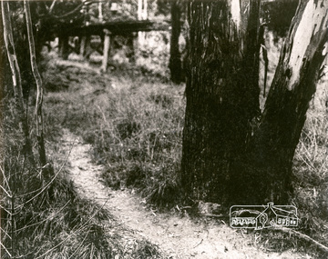
Photograph, Tree and Trestle Bridge, Eltham
Black and white photograph showing a track winding past an old gum tree towards the Trestle Bridge at Eltham in the distancepioneers and painters, bridges, eltham -
 Ringwood and District Historical Society
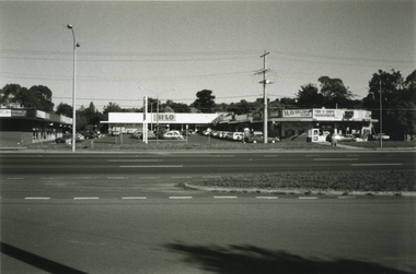
Photograph-B&W, Joan Walker, East Ringwood 2000-Burnt Bridge Shopping Centre, Maroondah Highway, 2000
East Ringwood 2000-Burnt Bridge Shopping Centre, Maroondah Highway- B&W Photo from Album 6501 -
 Federation University Historical Collection
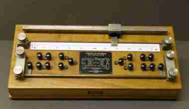
Instrument - Scientific Instrument, J.L. William Instruments, Kelvin Bridge
In 1993 this item was held in the Mt Helen Physics Department Optics Laboratoryc1870 as SMB start date but could be much earlier Student's type Kelvin Bridge Type KB/3R mounted on polished wood, with a range pf 0.000010HM to 0.1 OHM.scientific instruments, kelvin bridge, optics laboratory -
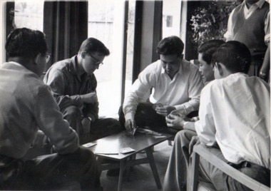 International House, The University of Melbourne
Photograph (Item), Richard Shiell, 10 Ways of Filling in Time at International House - 4: "One Quick Rubber (Bridge was very popular)", 1960
A quiet moment playing cards in the Common Room, this photo illustrates the many benefits International House presented to its residents, giving space for social and everyday interactions with diverse peoples, to the benefit and enjoyment of all. This photograph comes from an 'Album of Student Activities 1960', compiled and presented to International House by Soedjadi Satrosoegito & Richard Shiell.social, card games -
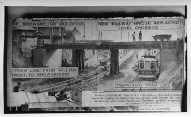 Melbourne Tram Museum
Photograph - Black and White, Epson Road Rail Bridge under construction, Early 1925
Image shows a newspaper photo of the MMTB U Class Tram 203 on temporary track at east side of excavation for underpass in Epson Road Flemington with Racecourse railway line to eliminate level crossing. The road was often closed to all traffic, including trams on race days by the railways. The work was completed in April 1925MMTB U Class trams were built for the former operator NMETL, with the photo showing an early level crossing abolition project. Black and White photo Epson Road Rail Bridge under construction with MMTB U Class tram on temporary track tramways, trams, epson road bridge, u class, flemington, tram 203 -
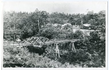
 Orbost & District Historical Society
black and white photographs, Howard D. Bulmer, first half 20th century
This bridge was built in the 1920s as a road and rail bridge, and was partly washed away by flood waters in 1934. After the end of the first World War the Victorian Railways considered an extension of the railhead across the river at Orbost, and in 1922 a new timber and steel girder structure, a joint Country Roads Board — Victorian Railways venture, was built and completed at a cost of £41,000 (the steel girders came from the Flinders Street viaduct reconstruction). Subsequently it was decided not to take the railway across the river, and the bridge has only been used by road traffic. This is a pictorial record of an early bridge across the Snowy River at Orbost.A large black / white photograph of the Orbost Snowy River bridge. There is a large copy as well as a postcard copy in sepia.on front - Snowy River Bridge Orbost H.D. Bulmer - photo - Lake Tyers.snowy-river-bridge-orbost -
 Orbost & District Historical Society
black and white photograph, c1920-1954
This is a copy of "THE BRIDGE AT BOGGY CREEK, NOWA NOWA, LAKE TYERS." which is a Rose Stereograph Co postcard. Boggy Creek Bridge was built in 1916 as part of the Bairnsdale to Orbost extension to the main Gippsland Railway, and is situated in the middle of the township of Nowa Nowa, crossing a steep-sided and well-timbered creek-valley. This section of the line closed in 1987. This bridge plays a major part in the identity and history of the town of Nowa Nowa, This item is associated with the East Gippsland Railway.A large black / white photograph of a large wooden bridge across a creek. There is a house and outbuildings in the background on the right. It is in a bush setting. on back - "Boggy Creek bridge - Nowa Nowa 1887 LaTrobe Collection"boggy-creek-bridge east-gippsland-railway -
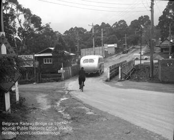 Southern Sherbrooke Historical Society Inc.
Photograph, Belgrave Railway Bridge, 1947
Belgrave railway bridge looking towards Bayview Road from Terrys Ave, 1947. It shows a bus crossing the bridge onto (now) Belgrave-Gembrook Road, followed by a male cyclist wearing a dark overcoat and bowler hat. A man wearing a homburg hat is crossing the footbridge beside the main bridge towards the main street. There is a pale van parked (or driving past) a dairy on the corner of Bayview Rd and Belgrave-Gembrook Road. A brick toilet block is shown with a sign saying 'MEN' on a nearby lamp post. -
 Ballarat Tramway Museum
Postcard, Murfett Pty Ltd, Princes Bridge Melbourne, c1968
Colour postcard of Princes Bridge and South Gate Fountain Melbourne, late 1960's. Postcard shows the southern end of the Princes Bridge, has 3 W2's on bridge, each with marker lights and the South Gate fountains, existing at the time of the photograph. Since replaced by the Arts Centre. On rear is printed caption, giving details of the location, the date of the fountain construction (1959), stamp placement area and publishers details and post card number (8P 1053-2), National View by Murfett Publishers.On top edge near stamp area in black ink "1968".trams, tramways, melbourne, southgate, princes bridge, mmtb -
 Coburg Historical Society
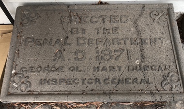
Artwork, other - Plaque (intended) for Murray Road Bridge, Bluestone Plaque intended for Murray Road Bridge, 1871
The plaque was originally intended for the Murray Road Bridge. The Murray Road Bridge is of state historical and architectural significance. With the Newlands Street Bridge it is one of a pair of bluestone bridges constructed by prison labour in Coburg and is situated within the immediate vicinity of the Pentridge Prison. The bridge has one of five largest spans of stone bridges built in Australia, of which at least three survive. (VHR)BluestoneErected by the Penal Department A.D. 1871 George Oliphant Duncan Inspector General -
 Kew Historical Society Inc
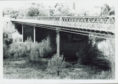
Photograph - Outer Circle Railway Viaduct
The heritage listed Fairfield Bridge was originally constructed for the Outer Circle Railway to bridge the Yarra River between East Kew and Fairfield stations. In the 1930s it was converted for vehicular traffic. In the 2010s a new concrete bridge was erected beside it to increase vehicular capacity.Print copy, enlarged from original snapshot, of the former railway viaduct crossing the Yarra and linking Kew and Fairfield. The original photo predates the conversion of the viaduct into the Chandler Highway Bridge in the 1930s, when the Bridge was adapted to carry vehicular traffic. The date on the reverse indicates the date of donation rather than the date on which the photograph was taken. CHANDLER HIGHWAY BRIDGE OVER RIVER / (ORIGINALLY PART OF OUTER CURCLE RAILWAY) / OCTOBER 1977railway viaduct -- kew (vic.), fairfield bridge, fairfield railway viaduct, outer circle railway, sir john monash -
 Mission to Seafarers Victoria
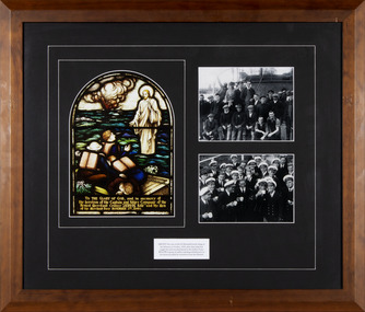
Photograph - Framed montage, Arthouse - Picture Framing & Gallery, Jervis Bay, 2013
THE SEAS IN WARTIME During WWII, as many as 27,000 men of the merchant and the King’s navy perished during active service. Dedicated to seafarers’ wellbeing, the Mission’s spiritual roots also make it a place for reflection on the loss of human life at sea. The Mission to Seafarers’ ministry offers its support in hundreds of seaports around the world, and has played an important role in supporting those who have lost friends and family at sea during wartime. Many of the stained glass windows in the chapel are dedicated to these people, and represent many close maritime community relationships. This window was installed in 1947 in recognition of the heroism and courage of those who have served in the Merchant Navy, and in particular to those who lost their lives aboard the armed merchant cruiser, ‘Jervis Bay’. This vessel was attacked by an enemy packet battleship whilst leading an escort from Nova Scotia to the UK in 1940.Reflections of the Sea was an exhibition of 10 framed montage of photographs from the mission's archive collection showcasing 10 stained glass windows from the St Peter chapel. This exhibition curated by Georgia Melville and Catherine McLay, and funded by PROV and Creative Victoria, was displayed in the World Trade Centre Wharf Gallery in June July 2013 and toured to Queenscliff Maritime Museum. The photographs of the windows were taken by scientific photographer Justine M. Philip. This frame is showcasing the memorial window to the Jervis Bay crew, a group photograph of the seamen from the SS Siltonhall and a group photograph of seamenFramed and mounted on black cardboard of black and white and colour reproductions from the MTSV collection for the exhibition Reflections of the Sea with brief label signageon label: ABOVE: VThe crew of the SS Siltonhall found refuge at the Mission in October, 1929, after their ship had caught fire and was abandoned in the Indian Ocean BELOW: A group of seafarers enjoying refreshments at the docks provided by volunteers from the Missionreflections of the sea, georgia melville, exhibition, 2013, world trade centre, wtc, hms jervis bay, ss siltonhall, siltonhall, ww2, creative victoria, prov, mission to seafarers, stained glass windows, justine m. philip, flinders street, catherine mclay, arthouse -
 Greensborough Historical Society
Photograph - Digital Image, Plenty Bridge Hotel, Lower Plenty, 1870s
Lower Plenty Hotel. This photograph shows the original Plenty Bridge hotel with Lower Plenty bridge in the foreground. The hotel was built c1858 and the bluestone bridge in the 1860s to replace the earlier toll bridge built in 1858.The close proximity of the hotel to the bridge is an indication of the importance of these river crossings in the mid 19th centuryDigital copy of black and white photographlower plenty, plenty river, plenty bridge hotel, lower plenty bridge, lower plenty hotel -
 Ringwood and District Historical Society
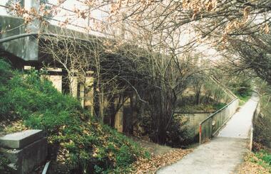
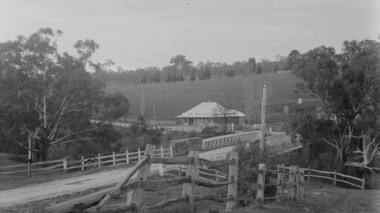
Photograph, Warrandyte Rd. Bridge, Ringwood. 1978
Written on back of photograph, "Warrandyte Rd. Bridge". Catalogue card dates photograph, "1/5/78" -
 Ringwood and District Historical Society
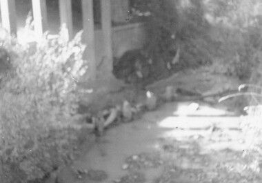
Photograph, Warrandyte Rd. Bridge over Mullum Creek, Ringwood, showing stumps of old piles (undated)
Poor quality, blurry photographWritten on back of photograph, "Warrandyte Rd. Bridge over Mullum Creek showing stumps of old piles". -
 Ringwood and District Historical Society
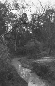
Photograph, Mullum Creek, 75 yds east of Warrandyte Rd. Bridge 1964
Possibly May 1971 as per item 2979?Typed below photograph, "Mullum Creek, 75 yds east of Warrandyte Rd. Bridge in centre". 1964