Showing 6040 items matching "historical buildings - melbourne"
-
 Greensborough Historical Society
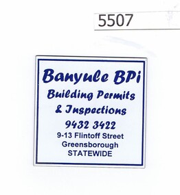
Refrigerator magnet, Banyule BPI, 2000c
Business now operating from Level 3/1 Flintoff Street Greensborough 3088, Tel. 9433 7777Refrigerator magnet, priinted in blue on white"Building permits and inspections", phone number and address at 9-13 Flintoff Streetbusiness cards, building permits -
 Greensborough Historical Society
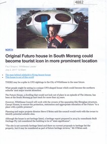
Article - Website, Paul Shapiro, Original Futuro house in South Morang, by Paul Shapiro, 02/07/2017
Of Finnish design, the building has been used as a sales booth at the Apollo Parkways estate, and moved to the TUKE Go-Kart Track on McDonalds Road South Morang, where it is being used as a storage building.3 p. text and col. and black and white photographs (digital reprint of original publication)futuro house, apollo parkways -
 Greensborough Historical Society
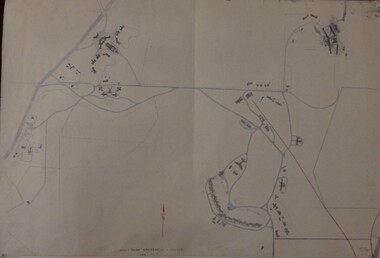
Maps, Mont Park, Gresswell, Larundel, 01/08/1949
Map of Mont Park area, including Larundel, Gresswell and Kingsbury Farm, between Plenty Road and Waiora Road, as at 1949, including buildings. Map of Mont Park area, including Larundel, Gresswell and Kingsbury Farm. Ink & pencil. Scale: 200': 1 inch49/147, R. G. H.mont park, larundel, gresswell watsonia, kingsbury -
 Greensborough Historical Society
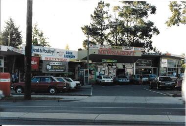
Photograph, Ian Bennetts, Briar Hill Shops 1990.1, 1990_
Briar Hill shops, corner Mountainview Road and Sherbourne Road.Photographs taken in 1990, many businesses have changed but the buildings remain in 2019.Colour photograph"Briar Hill shops 1990" (photo taken by Ian Bennetts)briar hill, mountainview road briar hill, sherbourne road briar hill -
 Greensborough Historical Society
Photograph, Ian Bennetts, Briar Hill Shops 1990.2, 1990_
Briar Hill shops, corner Mountainview Road and Sherbourne Road.Photographs taken in 1990, many businesses have changed but the buildings remain in 2019.Colour photograph"Briar Hill shops 1990 (photo taken by Ian Bennetts)"briar hill, mountainview road briar hill, sherbourne road briar hill -
 Greensborough Historical Society
Photograph, Ian Bennetts, Looker Road Montmorency Shops 1990, 1990_
Looker Road shops,Looker Road Montmorency.Photographs taken in 1990, many businesses have changed but the buildings remain in 2019.Colour photograph"Looker Rd shop 1990 Monty. (photo taken by Ian Bennetts)"montmorency, looker road montmorency -
 Greensborough Historical Society
Photograph, Ian Bennetts, Were Street Montmorency Shops 1990.1, 1990_
Shops corner Were Street and Rattray Road Montmorency. 1990Photographs taken in 1990, many businesses have changed but the buildings remain in 2019.Colour photograph"Montmorency 1990. Cnr Were St + Rattray Rd (photo taken by Ian Bennetts)"montmorency, were street montmorency, rattray road montmorency -
 Greensborough Historical Society
Photograph, Ian Bennetts, Were Street Montmorency Shops 1990.2, 1990_
Shops in Were Street Montmorency. 1990Photographs taken in 1990, many businesses have changed but the buildings remain in 2019.Colour photograph"Montmorency. .Were St. 1990 (photo taken by Ian Bennetts)"montmorency, were street montmorency -
 Greensborough Historical Society
Map, Municipality of Heidelberg Plan No. 480, 17/10/1948
Map shows streets, buildings, river and major drainage easements in area covered by West boundary Sellars Street, North boundary Yando Street & South boundary Grimshaw Street. Adjoins Map No. 481 to East. Black & white map, features marked in green, gradients in red. Scale: 160 feet to 1 inchgreensborough -
 Greensborough Historical Society
Map, Municipality of Heidelberg Plan No. 481, 23/9/1949
Central area of Greensborough, South boundary Grimshaw Street, showing river and buildings in green and gradients in red. Adjoins Map No. 480 to West.Black & white map with features in red and green. Scale: 160 feet to 1 inch.greensborough, grimshaw street greensborough -
 Greensborough Historical Society
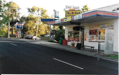
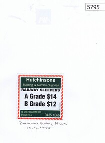
Newspaper Clipping, Diamond Valley News, Hutchinsons Building and Garden Supplies, 13/09/1995
An advertisement for Hutchinsons Building and Garden Supplies, 16 Sherbourne Road, Briar HillNewspaper clipping, black, red, green and white text.hutchinsons building and garden supplies, sherbourne road briar hill -
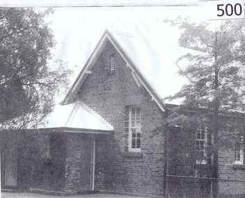
![Newspaper Clipping - Digital Image, Tighter security to deter vandals [Greensborough Primary School Gr2062], 2005_](/media/collectors/4f729f5697f83e03086015b8/items/5bb9926621ea6916dc018110/item-media/5bb9928821ea6916dc01a6b8/item-fit-380x285.jpg) Greensborough Historical Society
Greensborough Historical SocietyNewspaper Clipping - Digital Image, Tighter security to deter vandals [Greensborough Primary School Gr2062], 2005_
Vandals entered Greensborough Primary School grounds, causing damage to buildings and 'tagging' a student mural in the playground.Newspaper clipping, black and white text and colour image.greensborough primary school -
 Greensborough Historical Society
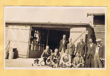
Photograph - Digital Image, Mystery mine photographs: Dairy and workers, 1935c
Dairy with workers outside – milk cans can be seen both inside and outside the timber building..An interesting collection of photographs, the connection to Greensborough remains a mystery. Digital copy of black and white photograph, one of 30 photos of mining operations.Photos have no markings or dates. Donor unknown.tasmania, dairy -
 Greensborough Historical Society
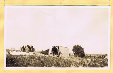
Photograph - Digital Image, Mystery mine photographs: Building staff quarters, the start, 1935c
This photograph shows the start of building workers huts at the mine site..An interesting collection of photographs, the connection to Greensborough remains a mystery. Digital copy of black and white photograph, one of 30 photos of mining operations. Photos have no markings or dates. Donor unknown.tasmania, mines and mining, mining machinery -
 Greensborough Historical Society
Photograph - Digital Image, Mystery mine photographs: Building staff quarters, with tripod, 1935c
This photograph shows the start of building workers huts at the mine site, with a tripod set up to lift the building components...An interesting collection of photographs, the connection to Greensborough remains a mystery. Digital copy of black and white photograph, one of 30 photos of mining operations. Photos have no markings or dates. Donor unknown.tasmania, mines and mining, mining machinery -
 Greensborough Historical Society
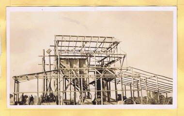
Photograph - Digital Image, Mystery mine photographs: Building staff quarters, nearing completion, 1935c
This photograph shows the workers huts at the mine site, nearing completion, with several completed huts in view..An interesting collection of photographs, the connection to Greensborough remains a mystery. Digital copy of black and white photograph, one of 30 photos of mining operations. Photos have no markings or dates. Donor unknown.tasmania, mines and mining, mining machinery -
 Greensborough Historical Society
Photograph - Digital Image, Mystery mine photographs: Building staff quarters with men outside, 1935c
This photograph shows the workers huts at the mine site, nearing completion, with men standing outside..An interesting collection of photographs, the connection to Greensborough remains a mystery. Digital copy of black and white photograph, one of 30 photos of mining operations. Photos have no markings or dates. Donor unknown.tasmania, mines and mining, mining machinery -
 Greensborough Historical Society
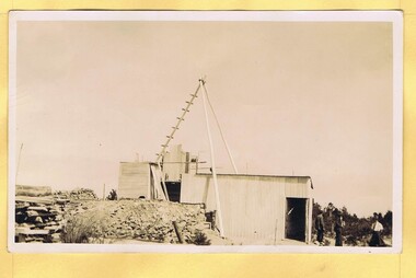
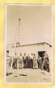
Photograph - Digital Image, Mystery mine photographs: Builing the crusher plant, 1935c
Building the crusher plant (two angles). Hopper (centre left) to feed crusher..An interesting collection of photographs, the connection to Greensborough remains a mystery. Digital copy of 2 black and white photographs, two of 30 photos of mining operations.Photos have no markings or dates. Donor unknown.tasmania, mines and mining, mining machinery -
 Greensborough Historical Society
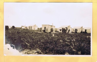
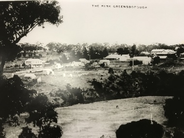
Photograph, The Park Greensborough, 1900c
View of Greensborough Park from Partington's Hill, showing sporting ground, Plenty River, Marble Hall, sparse housing on north side of Main Road, the Farmers' Arms hotel, the Rechabite Hall and Main Road bridge over the the railway line. Marble Hall is the double-storied building on the corner of Main Road.Part of a collection of 5 enlarged photographs dating from the early 1900s.Black and white enlargement of photographgreensborough park, main street greensborough, rechabite hall, farmers' arms hotel, marble hall, greensborough railway -
 Greensborough Historical Society
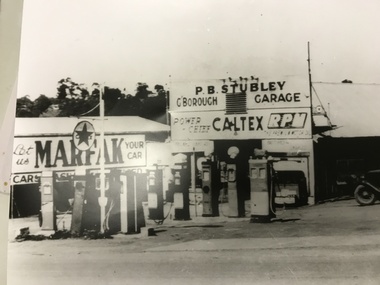
Photograph, Stubley's Garage, 1948c
Purcell Stubley bought the garage site in 1946, and this photograph would have been taken shortly afterwards. Note the multiple fuel bowsers, each selling a different brand. Watson Holden was on this site until the late 1970's. Then Woolworths constructed the current building which Savers now occupy. Part of a collection of photographic enlargements of Greensborough sites.Black and white enlargement of photographic imagestubley motors, main street greensborough, woolworths greensborough, watson holden, savers -
 Greensborough Historical Society
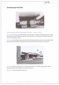
Article and Photograph, Greensborough Post Office, 2017_
Information and photos about the Greensborough Post Office, showing several buildings and locations for the post office.This photograph and text was copied from a Facebook site. Members are people who lived in the Greensborough area and share their reminiscences of the area with others. The site is administered by a GHS member but is not officially affiliated with the Society. Any information is the opinion of the contributor. Article and photograph sourced from social media.greensborough post office -
 Greensborough Historical Society
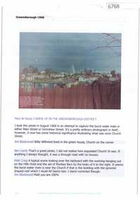
Article and Photograph, Greensborough 1968, 2016_
Information and photo of a burst water main in either Grimshaw or Main Street Greensborough. Photograph courtesy of Paul de Sauty, taken from Hailes Street. Church Street can be seen in this photo, prior to building of Greensborough Plaza.This photograph and text was copied from a Facebook site. Members are people who lived in the Greensborough area and share their reminiscences of the area with others. The site is administered by a GHS member but is not officially affiliated with the Society. Any information is the opinion of the contributor. Article and photograph sourced from social media.greensborough, church street greensborough -
 Greensborough Historical Society
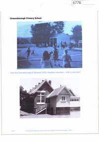
Article and Photograph, Greensborough Primary School, 2016_
Photos of Greensborough Primary School, the first showing children playing in the school yard, the second is of the original building.This photograph and text was copied from a Facebook site. Members are people who lived in the Greensborough area and share their reminiscences of the area with others. The site is administered by a GHS member but is not officially affiliated with the Society. Any information is the opinion of the contributor. Article and photograph sourced from social media.greensborough primary school, greensborough state school -
![Newspaper Clipping, Diamond Valley Leader, Children to rule again [Bundoora Primary School Bu1915], 06/06/2018](/media/collectors/4f729f5697f83e03086015b8/items/5b2498bd21ea671284fc9bed/item-media/5eabe7ff21ea670ff440eca5/item-fit-380x285.jpg) Greensborough Historical Society
Greensborough Historical SocietyNewspaper Clipping, Diamond Valley Leader, Children to rule again [Bundoora Primary School Bu1915], 06/06/2018
The former Bundoora Primary School building has reopened as a kindergarten and childcare centre. The Greensborough Historical Society have been especially interested and have been kind enough to share original photos of the building and class photos from the 1930s.News article 1 page, black text and colour images.bundoora primary school, greensborough historical society, nino childcare bundoora -
 Greensborough Historical Society
Article, Unknown, Bundoora Primary School No.1915, 1877_
Short history of the Bundoora Primary School no.1915 in Plenty Road. The building was erected in 1877. In 2014 the original building is all that is left with the Metropolitan Ring Road on the south border and commercial development to the north.Photocopy of article and photograph.bundoora primary school, janefield state school -
 Greensborough Historical Society
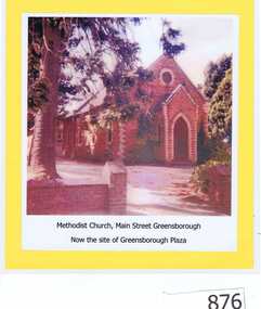
Photograph, Unknown, Methodist Church Main Street Greensborough, 1940c
The Greensborough Methodist Church stood in Main Street Greensborough and was central to the social life of the suburb in the early 20th century. This original site is now part of the Greensborough Plaza shopping complex. The Church moved to the new building in Grimshaw Street circa 1970s. This photograph shows the red brick church, now demolished.Copy of colour photograph of red brick church, mounted on yellow card and laminated.Caption: 'Methodist Church, Main Street Greensborough. Now the site of Greensborough Plaza'methodist church greensborough -
 Greensborough Historical Society
Newspaper Clipping, Diamond Valley News, Apollo Parkways School may start with 220 pupils, 24/10/1978
In 1978 Apollo Parkways Primary School [AP5184] was in the planning stages. In this article the Principal is named and plans for permanent buildings are discussed. The school opened in 1979.Information about the development of a new school in the Greensborough area.Photocopy of newspaper article,Date written on side.apollo parkways primary school, frank miller -
 Greensborough Historical Society
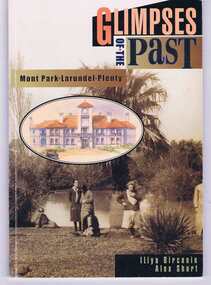
Book, Glimpses of the past: Mont Park, Larundel, Plenty. By Iliya Bircanin and Alex Short, 1909o
The psychiatric hospitals at Mont Park, Larundel and Plenty closed in the late 1970s and this book gives a brief history of the group of hospitals. The area has since been redeveloped into a residential area, although some of the original buildings remain.This book gives an outline of life within the hospital precinct.64 pages, illus. (some col.). Cover includes sepia photo 'Pond at Farm Worker's Block circa 1927'.mont park hospital, larundel hospital, plenty hospital, iliya bircanin, alex short, nemps, north eastern metropolitan psychiatric services -
 Greensborough Historical Society
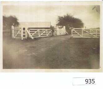
Photograph, Railway Gates at Grimshaw Street Greensborough, 1930c
Two women are standing at the railway crossing gates, ready to open or close the gates [Possibly Iredale family?]. Originally thought to be the rail crossing at Grimshaw Street and Old Greensborough Road. In 2023, there is doubt that this is the case due to the double rail line and building in background. Please contact the Society if you have any idea where this is located.Copy of photo of railway gates. Sepia.On back: "Godwill from Val Wilson"railway gates, rail crossing, iredale -
 Greensborough Historical Society
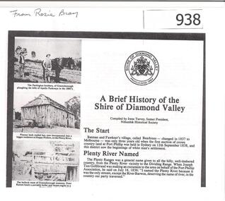
Article, Shire of Diamond Valley, A brief history of the Shire of Diamond Valley by Irene Turvey, 1837o
This brief history discusses the Shire of Diamond Valley. The Shire of Diamond Valley was a Local Government Area located about 20 kilometres northeast of Melbourne. The shire covered an area of 74.38 square kilometres and existed from 1964 until 1994.This article includes some images of early building in the Shire of Diamond Valley.Photocopied article. 4 pages text and illus.On front page "from Rosie Bray"shire of diamond valley, irene turvey