Showing 3153 items matching "miles"
-
 Ballarat Heritage Services
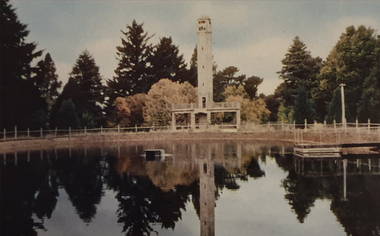
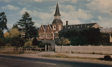
Photograph, Nucolorvue, Daylesford Pioneer Tower in Wombat Garrdens, 1957
Daylesford is a tourist town in Central Victorian, known for its mineral water springs.Image of the Daylesford Pioneer Memorial Tower in Wombat Gardens, Daylesford.Daylesford, Victoria, Australia This famous holiday resort is famous for its up-to-date facilities, as well as for its natural attractions. The mineral Springs are renowned for their high medicinal elements. The visitor finds ample to amuse, in excellent fishing, boating, Boating, Swimming, golfing, hiking and riding. The district provides a wide range of typical Australian bush scenery, and the altitude of 2,000 feet above sea level as a tonic effect on all. Daylesford has modern hotels, guest houses, shops and places of amusement, also many other places of interest within short travelling distance. Bendigo, 50 miles, Ballara 30 miles, and Melbourne 75 miles, bring Daylesford within easy reach of many parts of Victoria. daylesford, pioneer tower, wombat gardens -
 Ballarat Heritage Services
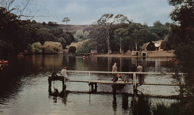
Photograph, Nucolorvue, A Corner of Jubilee Lake, Daylesford, 1957
Daylesford is a tourist town in Central Victorian, known for its mineral water springs.Image of Jubilee Lake, Daylesford.Daylesford, Victoria, Australia This famous holiday resort is famous for its up-to-date facilities, as well as for its natural attractions. The mineral Springs are renowned for their high medicinal elements. The visitor finds ample to amuse, in excellent fishing, boating, Boating, Swimming, golfing, hiking and riding. The district provides a wide range of typical Australian bush scenery, and the altitude of 2,000 feet above sea level as a tonic effect on all. Daylesford has modern hotels, guest houses, shops and places of amusement, also many other places of interest within short travelling distance. Bendigo, 50 miles, Ballara 30 miles, and Melbourne 75 miles, bring Daylesford within easy reach of many parts of Victoria. daylesford, jubilee lake, pier -
 Ballarat Heritage Services
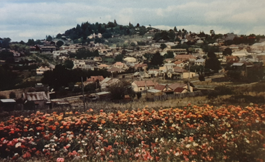
Photograph, Nucolorvue, Panorama Looking Towards Wombat Hill at Daylesford, 1957
Daylesford is a tourist town in Central Victorian, known for its mineral water springs.Panorama Looking Towards Wombat Hill at DaylesfordDaylesford, Victoria, Australia This famous holiday resort is famous for its up-to-date facilities, as well as for its natural attractions. The mineral Springs are renowned for their high medicinal elements. The visitor finds ample to amuse, in excellent fishing, boating, Boating, Swimming, golfing, hiking and riding. The district provides a wide range of typical Australian bush scenery, and the altitude of 2,000 feet above sea level as a tonic effect on all. Daylesford has modern hotels, guest houses, shops and places of amusement, also many other places of interest within short travelling distance. Bendigo, 50 miles, Ballara 30 miles, and Melbourne 75 miles, bring Daylesford within easy reach of many parts of Victoria. daylesford, wombat hill, flora -
 Ballarat Heritage Services
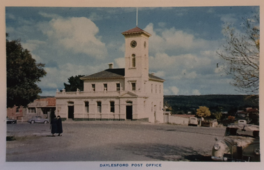
Photograph, Nucolorvue, Daylesford Post Office, 1957
Daylesford is a tourist town in Central Victorian, known for its mineral water springs.View of the Daylesford Post OfficeDaylesford, Victoria, Australia This famous holiday resort is famous for its up-to-date facilities, as well as for its natural attractions. The mineral Springs are renowned for their high medicinal elements. The visitor finds ample to amuse, in excellent fishing, boating, Boating, Swimming, golfing, hiking and riding. The district provides a wide range of typical Australian bush scenery, and the altitude of 2,000 feet above sea level as a tonic effect on all. Daylesford has modern hotels, guest houses, shops and places of amusement, also many other places of interest within short travelling distance. Bendigo, 50 miles, Ballara 30 miles, and Melbourne 75 miles, bring Daylesford within easy reach of many parts of Victoria. daylesford, daylesford post office -
 Ballarat Heritage Services
Photograph, Nucolorvue, Daylesford Primary School, 1957
Daylesford is a tourist town in Central Victorian, known for its mineral water springs.View of the Daylesford Primary SchoolDaylesford, Victoria, Australia This famous holiday resort is famous for its up-to-date facilities, as well as for its natural attractions. The mineral Springs are renowned for their high medicinal elements. The visitor finds ample to amuse, in excellent fishing, boating, Boating, Swimming, golfing, hiking and riding. The district provides a wide range of typical Australian bush scenery, and the altitude of 2,000 feet above sea level as a tonic effect on all. Daylesford has modern hotels, guest houses, shops and places of amusement, also many other places of interest within short travelling distance. Bendigo, 50 miles, Ballara 30 miles, and Melbourne 75 miles, bring Daylesford within easy reach of many parts of Victoria. daylesford, daylesford primary school, primary state school -
 Ballarat Heritage Services
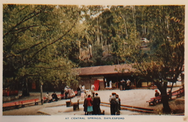
Photograph, Nucolorvue, Central Springs Daylesford, 1957
Daylesford is a tourist town in Central Victorian, known for its mineral water springs.Central Springs DaylesfordDaylesford, Victoria, Australia This famous holiday resort is famous for its up-to-date facilities, as well as for its natural attractions. The mineral Springs are renowned for their high medicinal elements. The visitor finds ample to amuse, in excellent fishing, boating, Boating, Swimming, golfing, hiking and riding. The district provides a wide range of typical Australian bush scenery, and the altitude of 2,000 feet above sea level as a tonic effect on all. Daylesford has modern hotels, guest houses, shops and places of amusement, also many other places of interest within short travelling distance. Bendigo, 50 miles, Ballara 30 miles, and Melbourne 75 miles, bring Daylesford within easy reach of many parts of Victoria. daylesford, central springs, mineral water, mineral water springs, kiosk -
 Ballarat Heritage Services
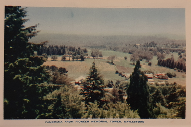
Photograph, Nucolorvue, Panorama from the Pioneed Memorial Tower, Daylesford, 1957
Daylesford is a tourist town in Central Victorian, known for its mineral water springs.Central Springs DaylesfordDaylesford, Victoria, Australia This famous holiday resort is famous for its up-to-date facilities, as well as for its natural attractions. The mineral Springs are renowned for their high medicinal elements. The visitor finds ample to amuse, in excellent fishing, boating, Boating, Swimming, golfing, hiking and riding. The district provides a wide range of typical Australian bush scenery, and the altitude of 2,000 feet above sea level as a tonic effect on all. Daylesford has modern hotels, guest houses, shops and places of amusement, also many other places of interest within short travelling distance. Bendigo, 50 miles, Ballara 30 miles, and Melbourne 75 miles, bring Daylesford within easy reach of many parts of Victoria. daylesford, wombat gardens, wombat hill gardens, daylesford pioneer memorial tower, landscape -
 Ballarat Heritage Services
Photograph, Nucolorvue, First Fairway of Golf Course, Hepburn, 1957
Daylesford is a tourist town in Central Victorian, known for its mineral water springs.The first course at the Hepburn Golf Club.Daylesford, Victoria, Australia This famous holiday resort is famous for its up-to-date facilities, as well as for its natural attractions. The mineral Springs are renowned for their high medicinal elements. The visitor finds ample to amuse, in excellent fishing, boating, Boating, Swimming, golfing, hiking and riding. The district provides a wide range of typical Australian bush scenery, and the altitude of 2,000 feet above sea level as a tonic effect on all. Daylesford has modern hotels, guest houses, shops and places of amusement, also many other places of interest within short travelling distance. Bendigo, 50 miles, Ballara 30 miles, and Melbourne 75 miles, bring Daylesford within easy reach of many parts of Victoria. daylesford, fairway, hepburn golf course -
 Ballarat Heritage Services
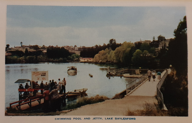
Photograph, Nucolorvue, Swimming Pool and Jetty, Lake Daylesford, 1957
Daylesford is a tourist town in Central Victorian, known for its mineral water springs.Swimming Pool and Jetty, Lake DaylesfordDaylesford, Victoria, Australia This famous holiday resort is famous for its up-to-date facilities, as well as for its natural attractions. The mineral Springs are renowned for their high medicinal elements. The visitor finds ample to amuse, in excellent fishing, boating, Boating, Swimming, golfing, hiking and riding. The district provides a wide range of typical Australian bush scenery, and the altitude of 2,000 feet above sea level as a tonic effect on all. Daylesford has modern hotels, guest houses, shops and places of amusement, also many other places of interest within short travelling distance. Bendigo, 50 miles, Ballara 30 miles, and Melbourne 75 miles, bring Daylesford within easy reach of many parts of Victoria. daylesford, swimming pool and jetty, lake daylesford, swimming -
 Ballarat Heritage Services
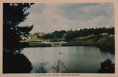
Photograph, Nucolorvue, A Section of Lake Daylesford, 1957
Daylesford is a tourist town in Central Victorian, known for its mineral water springs.A Section of Lake DaylesfordDaylesford, Victoria, Australia This famous holiday resort is famous for its up-to-date facilities, as well as for its natural attractions. The mineral Springs are renowned for their high medicinal elements. The visitor finds ample to amuse, in excellent fishing, boating, Boating, Swimming, golfing, hiking and riding. The district provides a wide range of typical Australian bush scenery, and the altitude of 2,000 feet above sea level as a tonic effect on all. Daylesford has modern hotels, guest houses, shops and places of amusement, also many other places of interest within short travelling distance. Bendigo, 50 miles, Ballara 30 miles, and Melbourne 75 miles, bring Daylesford within easy reach of many parts of Victoria. daylesford, swimming, lake daylesford -
 Ballarat Heritage Services
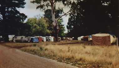
Photograph, Nucolorvue, Caravans in Victoria Park Camping Ground, Daylesford, 1957
Daylesford is a tourist town in Central Victorian, known for its mineral water springs.Caravans in Victoria Park Camping Ground, DaylesfordDaylesford, Victoria, Australia This famous holiday resort is famous for its up-to-date facilities, as well as for its natural attractions. The mineral Springs are renowned for their high medicinal elements. The visitor finds ample to amuse, in excellent fishing, boating, Boating, Swimming, golfing, hiking and riding. The district provides a wide range of typical Australian bush scenery, and the altitude of 2,000 feet above sea level as a tonic effect on all. Daylesford has modern hotels, guest houses, shops and places of amusement, also many other places of interest within short travelling distance. Bendigo, 50 miles, Ballara 30 miles, and Melbourne 75 miles, bring Daylesford within easy reach of many parts of Victoria. daylesford, victoria park caravan park, camping, victoria park, caravan park -
 Ballarat Heritage Services
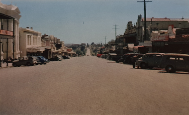
Photograph, Nucolorvue, Vincent Street Daylesford Looking Towards Hepburn Springs, 1957
Daylesford is a tourist town in Central Victorian, known for its mineral water springs.Vincent Street Daylesford Looking Towards Hepburn SpringsDaylesford, Victoria, Australia This famous holiday resort is famous for its up-to-date facilities, as well as for its natural attractions. The mineral Springs are renowned for their high medicinal elements. The visitor finds ample to amuse, in excellent fishing, boating, Boating, Swimming, golfing, hiking and riding. The district provides a wide range of typical Australian bush scenery, and the altitude of 2,000 feet above sea level as a tonic effect on all. Daylesford has modern hotels, guest houses, shops and places of amusement, also many other places of interest within short travelling distance. Bendigo, 50 miles, Ballara 30 miles, and Melbourne 75 miles, bring Daylesford within easy reach of many parts of Victoria. daylesford, vincent street, streetscape -
 Ringwood and District Historical Society
Book, Ringwood District Philatelic Society Members Attendance Book 1952 to 1970, 1950s
Donated by the Ringwood Philatelic SocietyGreen covered book with cream spine 202 pp., containing members and visitors attendance at meetings from 6-Jun-1952 (The inaugural meeting) 7o 6-Aug-1970. Picture in front of members 7-Aug-1953. +Additional Keywords: L-R: / Wenn, Mrs / Unknown / McCaskill, J / Griffiths, S / K W / Miles, P / Duerdoth, P / McEwan, Mrs E.Members Attendance Book (on front cover) -
 Kiewa Valley Historical Society
Map - Topographical, Ski Club of Victoria Bogong High Plains and Adjacent Peaks, Early 1930's
This map has been in the Ryder family for approx. 70 years. Probably used when bush walking and skiing in the early days on the Bogong High Plains. The Ryder family are farmers in the Kiewa Valley and were involved in taking their cattle up to the Bogong High Plains where they had a lease. The State Electricity Commission of Victoria constructed the Kiewa Hydro Electric Scheme opening up the area during the 1940's and 1950's. This type of map is an early one, used by people in the Kiewa Valley and possibly by surveyors prior to construction.The map is an early topographic map used by farmers living in the Kiewa Valley. It is historically significant as these people were involved in taking cattle up to the High Plains during summer and may have been used for bush walking and skiing.This is a sepia coloured paper map which was originally printed copyright registered. It was revised in 20/6.33/4.4.37/8.4.40/24.8.43/19/6/54. It shows roads / tracks / snow poles / snow pole numbers (27) / Snow pole spacing (3 chains. 66 yards) approximately 27 poles to the mile / height above sea level in feet - 5280. Water courses not definitely located etc.Rocky Valley Dam (Kiewa Hydro Electric Scheme) has been drawn on the map by hand with a biro. There is a wooden rod at the top of the map.topographic map; kiewa valley; ryder family; high plains of victoria -
Frankston RSL Sub Branch
Computer, Navigation
Aerial Dead Reckoning Computer in leather pouch. This device was used as a navigational aid by aircraft pilots and crew. W&G Aerial Dead Reckoning Computer R.A.A.F. Mk 1 Made in Australia by White & Gillespie Front Scale: Distance Naut Miles, True Air Speed (Time Min, Hrs, Density Altitude, Air Temp ) Back Scale: Wind Correction Angle( True Heading ) The leather pouch has the following printed on the outside "W&G Aerial Dead Reckoning Computer R.A.A.F. Mk 1" -
Ringwood and District Historical Society
Documents, Packet: Ringwood Antimony Mine Correspondence and Clippings. Kenny Paper 1942; Miner's Cottage Field Notes etc, 1874-1970
Various papers relating to the Ringwood Antimony Mine; Paper by J.P.L. Kenny B.G.E. 1942; Various newspaper cuttings; Field notes by D. Brown - Miner's Cottage; Mining By-Laws 1916 (McKaskill); Share scrip Montezuma Mining Company Holding 200 December 1901; Miner's Right - 8 November 1907 +Additional Keywords: Kenny, J - B.G.E. / Brown, D / McCaskill / Temple Miles, A -
 Bendigo Historical Society Inc.
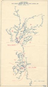
Map - STATE RIVERS AND WATER SUPPLY COMMISSION : COLIBAN DISTRICT MAP 1956, 30/11/1956
State Rivers and Water Supply Commission Coliban District map. Titled: S.R. & W.S.C. Coliban District Plan showing Irrigation and Town Supply Channels 1956. Scale: 1 inch = 4 miles. Indicates concrete lining and concrete re-lining channels. Printed in blue ink and information added in red. The map is dated at the bottom - 30/11/'56. There is a number, 25,491, in the bottom right corner.state infrastructure, water supply, coliban system, state rivers and water supply commission. coliban system. -
 Bendigo Historical Society Inc.
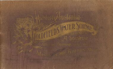
Book - WESTERN AUSTRALIA GOLDFIELDS WATER SCHEME
A souvenir of the official opening of the Western Australia Goldfields Water Scheme and visit to the mines of the Golden Mile. Published by The Chamber of Mines of Western Australia Incorporated, Kalgoorlie. 24 - 26th January 1903. Printed by F. W. Niven & Co. 40 - 42 Flinders Street , Melbourne. The cover is maroon colour (now very faded) with gold lettering. The booklet contains Many photos of the Kalgoorlie and Boulder mines.Printed by F.W. Niven & Co. 40-42 Flinders Street, Melbourne.civil engineering, water supply, goldfields, goldfields water scheme, western australia, kalgoorlie, mining, water supply -
 Bendigo Historical Society Inc.
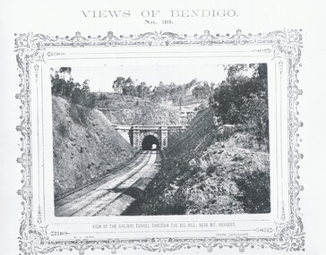
Photograph - VIEWS OF BENDIGO, VIEW OF RAILWAY TUNNEL THROUGH THE BIG HILL, 1875 Copy,1970
Sepia photo on a cram board. Shows a railway tunnel through Big Hill near Mt. Herbert. Inscription: Above, 'Views of Bendigo|No.39.'. Below,'View of the Railway Tunnel through the Big Hill near Mt. Herbert', 'N.J.Caire Photo, Sandhurst'. Bottom, 'Casey & Wenborn's Print Forbes & Holmes, Agents',' The length of the Tunnel is about half-a-mile through the hill'. (two copies) Nicholas CaireN.J.Caireplace, bendigo, tunnel through big hill, see: 'views of bendigo' by n .j .caire. 'mp 157' -
 Bendigo Historical Society Inc.
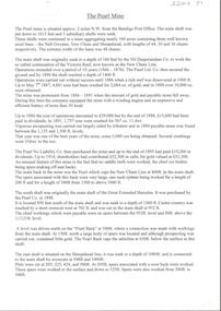
Document - ALBERT RICHARDSON COLLECTION: THE PEARL MINE
Typed, 2 page document, detailing the location and history of the operation of the Pearl Mine. The mine was located approximately 2 miles north west from the Bendigo Post Office. The main shaft was put down to 1613 feet and 3 subsidiary shafts were sunk, Information is given about the south shaft, originally the main shaft of the Great Extended Hercules and the east shaft, which was situated on the Sheepshead line.bendigo, mining, pearl company mine -
Tatura Irrigation & Wartime Camps Museum
Document, Certificate of Right of Burial in the Tatura Public Cemetery, Lease,Account from West End Timber Yards for Coffin
Photocopies of original documentsPhotocopies of Certificate of Right of Burial in the Tatura Public Cemetery dated 15/01/1906 and 2 receipts for same plots labelled Toolamba West Public Cemetery dated 6/12/1905, Lease between John Herbert Davies & Catherine Heaphy for the Criterion Hotel Tatura, Account from West End Timber Yards (A. Miles) for Coffin and Hearse & Conducting Funeral. All are photocopies on A4 paper.tatura, heaphy, cemetery, criterion hotel, west end timber yards, davies, cussen, documents, certificates -
 Yarrawonga and Mulwala Pioneer Museum
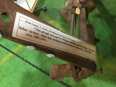
Plough, The Plough, 1860
Hugh Lennon began making ploughs in Carlton from 1960 and within 10yrs the patented steel plough ,suitable to Australian conditions was outselling all imported cast iron mouldboard ploughs. This general purpose mouldboard plough was used to form the streets in Yarrawonga during the 1880's........from James A. Irwin of Oaklands [formerly Lake Rowan] "This plough was used by William Christians and John Holmes [Jim Irwin's father -in-law]when they worked on the formation of Belmore St, Yarrawonga" circa 1880- 1890'sThe early settlers [1870] used this type of plough pulled by one horse.to prepare their ground for wheat sowing. From the early 1880's the double -furrow plough came into general use, pulled by 2 horses. Being a wheeled machine, it allowed the ploughman to sit on the plough and save miles of walking during ploughing operations. Over the years ploughs became bigger, and needed more horses to pull them. -
 Tarnagulla History Archive
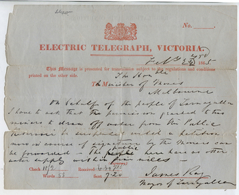
Telegram: Mayor of Tarnagulla to the Minister of Mines, Melbourne, 22nd February 1865
Murray Comrie Collection. A telegram sent from James Ray, Mayor of Tarnagulla to the Minister for Mines, Melbourne on 22nd February 1865. Reads: "On behalf of the people of Tarnagulla I have to ask that the permission granted to two miners to draw off water from the Public Reservoir be suspended until a petition now in course of signatures by the miners can be forwarded. The public here have no other water supply within five miles."tarnagulla, post office, telegrams, minister mining, mining, water, reservoir, recreation reserve, resources -
Bendigo Historical Society Inc.
Photograph - A.PHILPOTT ATHLETIC CUPS PHOTO AND NEWSPAPER ARTICLE, 1940s
St Mark's Harriers was established in Sunshine by the minister of St Mark's Church of England in 1931. It operated until 1964/65 A full biography of race walker, Alex Philpott is available at:- https://www.vrwc.org.au/tim-archive/articles/wv-alex-philpott.pdfColoured photo shows A. Philpott wearing shash of St. Mark's Harriers Club standing in front of a number of club trophies. He came to Bendigo for many racing championships, competing in state and national walk events for many years. In 1949 he won the Victorian 10 mile walk. Newspaper cutting (Mobil News April 1970) relates his continued involvement in walking and helping junior walkers.Hilda Mitchell (Footscray)trophies & awards, sports, athletics -
 Melbourne Tram Museum
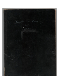
Book, H.S. McComb, "Lengths of Lines and Curves", c1930
Book - black covers - 4 sections sewn - 124 pages lined - titled "Lengths of Lines and Curves". Has an index. Gives details of junction layouts, distances, hand drawing layouts, route and track miles, tables of actual distances, average distance and figure on which mileage is worked. In the rear of the book are some hand written calculation notes. Not all pages imaged, just those with a diagram.On top of the cover of one copy in ink "pages 1, 4, 14,17, 23"trams, tramways, trackwork, mmtb, mileages -
Tatura Irrigation & Wartime Camps Museum
Booklet - Book, History of the Waranga Basin, 1977
As part of rich history of Rushworth after gold was discovered. Gunn's swamp became Waranga Basin when a 24 miles channel was constructed from the Goulburn Weir to the inlet.Blue cover, black writing, yachting scene on front cover. Waranga basin inlet and outlet pictures on the backJoyce Hammond 19/8/77irrigation, books, history, local -
 Wonga Park Community Cottage History Group
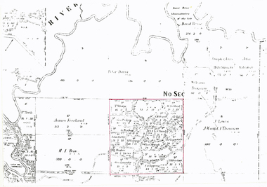
Photograph (sub-item) - Map of original land settlement in 1890’s – known as ‘the Eight Hour Pioneer village Settlememt’, the square mile around the Wonga Park Store today (red square)
Map of original land settlement in 1890’s – known as ‘the Eight Hour Pioneer village Settlememt’, the square mile around the Wonga Park Store today (red square). -
 Eltham District Historical Society Inc
Document - Folder, Survey Maps and Technical Drawings
alan gardiner collection, maps