Showing 774 items matching "proposed plans"
-
 Melbourne Tram Museum
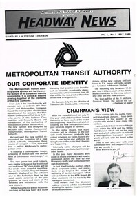
Magazine, Metropolitan Transit Authority (MTA), "Headway News", July 1983 to July 1984
Magazine, published by the Metropolitan Transit Authority of Victoria "Headway News" - A4 printed on white gloss paper, with the MTA logo or symbol. Issued under the name of L. A. Strouse as Chairman of the body which commenced on 1/7/1983. Major tram and bus items listed. .1 - Vol 1 No. 1 - July 1983 - four pages - gives details of corporate identity, including notes on the design of the logo, notes from the Chairman, details of the Management Team, the Board, move to the new head office - World Trade Centre, Preston Workshops Project. Management Team - Albrecht Scholer (Metro rail), Dudley Snell (trams), John Wagstaff (GM Marketing and Sales), Michael Maude (GM Personnel) and Paul Riboni (GM - Finance and Corporate). .2 - Vol 1 No. 2 - August 1983 - four pages - details the MTA Board with a photo, gives details of the intended directions that the MTA is planning to take, western suburbs and Doncaster bus changes, new bus workshop at Northcote. Photo notes Bill (W) Aird as Interim Secretary of the MTA. MURLA. .3 - Vol 1 No. 3 - September 1983 - four pages - Flinders St station redevelopment, METROL, AVM - vehicle monitoring, Employees Board Member election and sports roundup. .4 - Vol 1 No. 4 - October 1983 - six pages (one sheet folded) - Refurbishment of W5 trams - fitting of sliding doors, Bundoora Extension, Tram Priority, management changes - Level 3 - John Grigg and Geoff Carkeek, early retirement seminars, transport loan, upgrade to rail overhead, Bob Drummond Retires, flat fares, Gail Moody project engineer for Bundoora Extension and MTA at Royal Show. .5 - Vol 1 No. 5 - November 1983 - eight pages - two sheets - intro of new fare system on 13/11/1983 - "the Met", (Travel Cards and neighbourhood tickets), tram priority, training in new ticketing system, profile of Paul Riboni, restructure of the Metro Rail division, New A class trams, notes restarting of alphabet, cost containment, early retirements, election of employee Reps (Norm Maddock and Tony Tuohey), sporting news, Preston Workshops redevelopment and tram 520 goes to Elton John. .6 - Vol 1 No. 6 - December 1983 - single sheet, two pages with a Christmas message and consultation committees will work during 1984. .7 - Special Edition 1984 - one page - message from the Chairman and Managing director, - re on time running, METROL and planning for 1984. .8 - Vol 2 No. 1-2, January - February 1984 - four pages - METROL now in operation, new managers - John Coulson ex MMTB Assistant Secretary and financial manager, tram and bus appointments, "trams that bend in the middle" - launch of B class trams, sport - Cricket carnival. .9 - Vol 2 No. 3 - March 1984 - four pages- "charting the football crows, proposed head office at 60 Market St (did the World Trade Centre in first issue ever happen?), Colin West Group Manager Personnel - ex MMTB Personnel, Robin Ould employee relations - ex MMTB Industrial Officer. Has a profile on John Wagstaff, interstate cricket and new apprentices. Includes an item on the down fall of Sydney tram network - "The fall of the Giant" .10 - Vol 2 No. 4 - April 1984 - four pages - John Grigg appointed as Chief GM Metro Rail, OH&S Bill, train defects, Tony Jackson bus mechanic wins award, Beppie - Welfare Counsellor for MTA Tram and Bus based at Hawthorn depot. .11 - Special Edition - 1984 - single page- "Met Birthday address by Chairman". The continues to:trams, tramways, mta, preston workshops, board members, management, northcote bus workshops, avm, flinders st, w5 class, bundoora, tram priority, retirements, fares, royal show, funding, sale of trams, a class, travel cards, neighbourhood tickets, b class, cricket, sydney, welfare -
 Melbourne Tram Museum
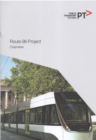
Document - Report, Public Transport Corporation (PTC), "Route 96 Project Overview", 2012
Report 12 A4 pages, including card covers, centre stapled, full colour printed on off white paper, titled "Route 96 Project Overview". Looks at the route itself, project objectives, governance arrangements, communications and consultations. Includes a note that the Government has order 50 new trams. Notes the proposed works packages and who would be managing them - VicRoads, Yarra Trams or PTV. Includes photos of Bourke St, street plans and information numbers. Has the State Government, VicRoads and Yarra Trams logos. Published 2012.trams, tramways, ptv, route 96, east brunswick, yarra trams -
 Melbourne Tram Museum
Document - Report, McCarty Underwood & Co, "Proposed Melbourne to Burwood Electric Tramway", May 1914
The report titled "Proposed Melbourne to Burwood Electric Tramway and Electrification of Hawthorn Horse Tramway" by McCarty Underwood dated May 1914. Report prepared as a precursor to the formation of the Hawthorn Tramways Trust. The report looks at the estimated costs, revenue, expenditure and engineering difficulties. Only considered a line to Burwood, not Wattle Park. Has a page looking at the use of Storage Battery cars. Yields information about the establishment of the Burwood tram line.Report - 16 printed foolscap sheets plus a fold out plan in colour, centre stapled.Has "1" in a circle in indelible pencil in the top right hand corner.tramways, tramcars, htt, burwood, report, battery trams -
 Melbourne Tram Museum
Document, Engage Victoria, Footscray and Maribyrnong Tram Corridor Planning _ Engage Victoria, July 2024
Digital document from Engage Victoria looking at options and feedback for possible changes to the Route 82 route in Maribyrnong and Footscray areas for the introduction of low platform stops in Gorden St and Droop St. Includes a map for proposed stops and existing stops. The document notes that funding for stop upgrades is part of a future budget process.Demonstrates a Consultative document by Engage Vic. August 2024.Digital document - 11 pagestramways, platform stops, footscray, maribyrnong, route 82, consultation -
Melbourne Tram Museum
Document, Engage Victoria, Route 86 Tram Corridor Planning _ Engage Victoria, April 2024
Digital document from Engage Victoria looking at options and feedback for possible changes to the Route 86 route in Fitzroy and Northcote areas for the introduction of low platform stops in Gertrude, High and Smith Sts. Includes a map for proposed stops and existing stops. The document notes that funding for stop upgrades is part of a future budget process.Demonstrates a Consultative document by Engage Vic. April 2024.Digital document - 10 pagestramways, platform stops, consultation, route 86, fitzroy, northcote, smith st, gertrude st, high st -
 Melbourne Tram Museum
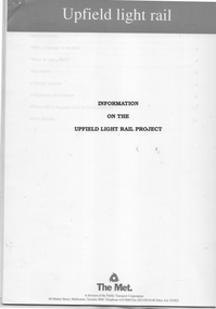
Document, The Met, "Information on the Upfield Light Rail Project", 1990
... describing the project, planning timing including a proposed... the project, planning timing including a proposed timetable from ...Documents comprise: 15 page - information document describing the project, planning timing including a proposed timetable from the Coburg stop, Sydney Road tram shuttle, North Melbourne bus service, and ticket zones. 1 page letter and consultation form dated 30/1/1990 addressed to the AETA 1 page - notes on consultative meeting outcomes 1 page information note on the Upfield light rail 3 page document titled "The fourth option" - LRT and trams retained in Sydney RoadYields information about the proposals to convert the Upfield rail line to light rail.Set of documents - comprising 22 A4 printed pages.tramways, the met, upfield, light rail, new tramways, consultation -
 Melbourne Tram Museum
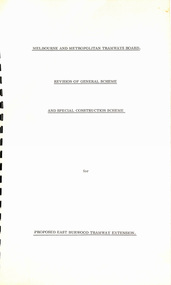
Document - Report, "Revision of General Scheme and Special Construction Scheme for Proposed East Burwood Tramway Extension", 1974
Report - Foolscap bound with black comb binder, 10 pages + two fold out drawings + card covers titled "Revision of General Scheme and Special Construction Scheme for Proposed East Burwood Tramway Extension", not formally dated (1974). Continuing information on the proposal such as route, existing services bus and rail, General Scheme, type of track construction, overhead, costs, fares, resumptions, plans. Includes plans P14604 (shows track arrangement) P14605 general location including the City of Melbourne.trams, tramways, east burwood, new tramways, general scheme, construction -
 Melbourne Tram Museum
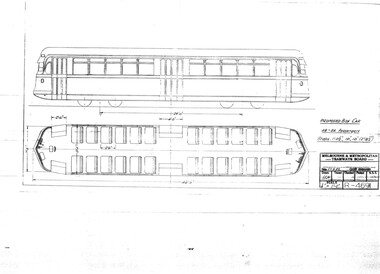
Drawing, Melbourne & Metropolitan Tramways Board (MMTB), "Proposed Box Car", Sep. 1937
... - streamliner approach. Gives side elevation and floor plan. "Proposed ...Print of drawing R4691, "Proposed Box Car" - with end and central doors, high floor - streamliner approach. Gives side elevation and floor plan.trams, tramways, sw6 class, w5 class, bogie trams, new tramcars, tramcar construction, proposals -
 Melbourne Tram Museum
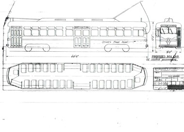
Drawing, Melbourne & Metropolitan Tramways Board (MMTB), "Proposed Box Car", Jan. 1955
Print of drawing R9495, "Proposed Box Car" - with one end and one large central door, high floor - streamliner US PCC approach. Gives side elevation and floor plan. Seats 52 passengers. Prepared 10/1/1955trams, tramways, pcc class, bogie trams, new tramcars, tramcar construction, proposals -
Canterbury History Group
Letter - Closure drives home mixed planning message, 3/05/2011 12:00:00 AM
Letter to the Progress Leader 3 May 2011, from Julianne Bell, Protectors of Public Lands Victoria, commenting on the closure of Bradshaws Auto Service and the proposed designation of Maling Road as a Neighbourhood Activity Centre. Includes a coloured photograph of David Bradshaw.canterbury, d.h.bradshaw auto service pty ltd, maling road, petrol stations, bradshaw> david, neighbourhood activity centres, town planning -
 Melbourne Tram Museum
Document - Report, Graeme Breydon, "Future Development of Tramways in the Melbourne Central Business District", Apr. 1973
Six paged duplicated paper or report titled "Future Development of Tramways in the Melbourne Central Business District", by Graeme Breydon, presented to the AETA 1973 Convention, based on an article prepared for the August 1972 issue of Electric Traction. Has references, looks at proposals for underground part of the Swanston St tramway, alternatives for flinders St and a Yarra crossing, St Kilda Road issues, William St, CBD problems and travel issues, shortcomings of proposals, alternatives, Flinders Gate interchanges, associated track improvements, cost benefit ratios, comments and conclusions. 2nd copy contains within a brown manila quarto sized folded marked "Tramways in the Melbourne. Central Business District" G. Breydon (Aug. 1972). See also Reg Item 3069 and 2812 for further references. .2 - letter - c Jan 1973 - carbon copy of a Letter to the Editor for response to a letter in Electric Traction Dec. 1972 responding to H. Moses and making specific comments. .3 - letter - 29/1/1973 to Graeme Breydon from the Ian Cooper of the AETA responding and accepting an offer of Graeme to present on the Board's plan for the forthcoming AETA Canberra Conference in April 1972. .4 - Report - 17 Quarto pages, stapled on the left hand side titled "Future Development of Melbourne Tramway System, with particular reference to possible improvements to the fixed plant of the Central Business District", written by Graeme Breydon, dated Jan. 1972. Refers to the 1962 report of Risson, and scheme presented to Council, Has hand drawn maps of the central area of Melbourne, Looks at the background, traffic issues, proposed underground loop, employment distribution, an extension to Elisabeth St, reversing loops, St Kilda Road and comments on the MMTB proposals. Refers to a paper delivered by D Lees, MMTB Planning Engineer, Swanston St underground proposal,on outside of the 2nd copy, and on top right hand corner of paper AETA Library mark "4E11"trams, tramways, mmtb, melbourne, traffic control, swanston st, st kilda rd, elizabeth st, bourke st, aeta, transportation, underground tramways -
 Melbourne Tram Museum
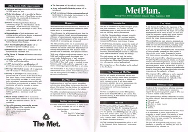
Pamphlet, The Met, "Met Plan", Sep. 1988
Folded A2 sheet to A4 size, full colour, printed both sides, titled "Met Plan" dated September 1988, detailing planning for Melbourne Public Transport, known as "MetPlan", prepared by The Met. Shows the various proposals for railway upgrades, tram extensions, details the purpose, the Task, Vision, Patronage, Resources, system improvements. Has details of projects proposed for the Western, Northern, Eastern and South Regions. On the inside has a large map of Melbourne showing the various projects. 2nd copy added 23-10-2016trams, tramways, melbourne, traffic control, transportation, met, planning, public transport, metplan, tramway proposals, railways -
 Melbourne Tram Museum
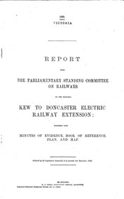
Document - Report, Victorian Parliament, "Report - The Parliamentary Standing Committee on the Proposed Kew to Doncaster Electric Railway Extension", Dec. 1930
Printed - 12 page foolscap, stapled on left hand side, 2 sections, Victorian State Parliamentary Report titled "Report - The Parliamentary Standing Committee on Railways on the Proposed Kew to Doncaster Electric Railway Extension", together with minutes of evidence, book of reference, plan and map, dated 4/12/1930. References a 1928 document, looks at construction costs, sites for railway stations, estimated revenue and expenditure, existing Kew line financials, town planning, bus services, MMTB input, tram services, alternatives, committee views, recommendations and a map of proposed routes, showing roads and tram services. Includes references to the Kodak estate and APM proposals at Fairfield. See Reg Item 2102.3 for the 1928 report.trams, tramways, doncaster, railways, public transport, kew -
 Melbourne Tram Museum
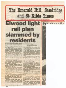
Newspaper, The Emerald Hill, Sandridge and St Kilda Times, "Elwood light rail plan slammed by residents", 8/09/1988 12:00:00 AM
Newspaper clipping from "The Emerald Hill, Sandridge and St Kilda Times", titled "Elwood light rail plan slammed by residents", 8 September 1988, about the proposed extension of the St Kilda Light rail line into Elwood; the residents using such terms as appalled, ridiculous, futile, traffic problems, though the City of St Kilda was supportive.trams, tramways, st kilda, elwood, light rail, new tramway -
 Melbourne Tram Museum
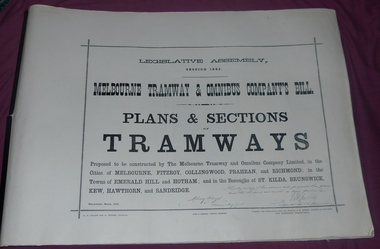
Document - Folder, Jack Cranston, "Melbourne Tramway & Omnibus Company's Bill - Plans and Sections - Tramways - March 1882", 1994
... of details on the plans and sections of proposed horse tram lines... Consists of five sheets with notes about the proposed horse tram ...Consists of five sheets with notes about the proposed horse tram system for Melbourne, prepared by Jack Cranston. Includes extract and notes on the parliamentary enquiry and the possibility of a cable tram system. The coloured sheet is from another copy held at the former VicTrack Malvern Museum. Images from the latter set of documents - Sept 2024. 35 Sheets of details on the plans and sections of proposed horse tram lines throughout Melbourne. Produced as part of the work undertaken by Jack Cranston for the Department of Transport / Heritage Victoria - see Reg Item 584. On rear cover ink and on page 2 of the folder is a note on the source of the document. See Inscriptions.Yields information about the proposed horse tram lines by MTOCo that were later developed as cable tram lines.Folder - photocopies or copy prints, A1 approx. size, 45 sheets, clipped together with two black side binders, titled - "Melbourne Tramway & Omnibus Company's Bill - Plans and Sections - Tramways - March 1882". On rear cover sheet, handwritten in black ink - "Constructed and compiled by Jack Cranston by permission from The Ambleside Museum Ferntree Gully Victoria. This is a copy of Original Size Folio"trams, tramways, cable trams, horse trams, mto co, melbourne -
 Melbourne Tram Museum
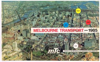
Pamphlet, Melbourne Transportation Committee, "Melbourne Transport 1985", c1971
Pamphlet, full colour, 14 pages (was 16 pages - one set has been removed or torn out) titled "Melbourne Transport 1985", reporting on the Melbourne Transportation Committee work, c1971. The document gives a summary of the recommendations of the Committee's planning for Melbourne transport for 1985, including the rail loop, proposed freeways and interchange facilities. Includes detailed planning for the Eastern Freeway, South Eastern Freeway and the Tullamarine Freeway. Showed some rail line extensions.On front cover in ink "4A12" and inside on page 3, "AETA" stamp in purple ink.trams, tramways, melbourne, transportation, planning -
 Melbourne Tram Museum
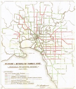
Document - Photocopy, "MMTB Proposals for General Scheme, c1970
... for General Scheme showing a detail plan of tramways proposed... Tramways Proposals Planning Colour photocopy of a MMTB drawing ...Colour photocopy of a MMTB drawing titled "MMTB Proposals for General Scheme showing a detail plan of tramways proposed for Melbourne 1923. Signed by J. Strickland 27-8-1923. Shows cable trams, existing tramways, authorised tramways, proposed, VR tramways, rail lines and waterways. Not known when colour copy actually made - could have been an AETA or a TMSV reproduction. See Reg Item 2089 for an original of this document.trams, tramways, mmtb, melbourne, cable trams, electric trains, tramways, proposals, planning -
 Bacchus Marsh & District Historical Society
Map, Rough plan showing proposed deviation of road through McKenzie's Flat
... The date of this map or plan is uncertain. McKenzie's Flat ...The date of this map or plan is uncertain. McKenzie's Flat is a bushland picnic area on the Lerderderg River in the Lerderderg State Park close to Bacchus Marsh. Single page map showing a proposed deviation of the road near the McKenzie's Flat area close to Bacchus Marsh. The proposed deviation is shaded in pink, The existing road section to be replaced is shaded in blue. No scale is indicated. Part of a set of maps which are pasted into a bound volume containing 76 maps or plans in total. High resolution digital image stored on BMDHS computer network. mckenzies flat bacchus marsh, bacchus marsh roads and streets -
Villa Alba Museum
Document, A case for the Development of a Centre of Excellence in Decorative Arts and Heritage Practice at Villa Alba, 2004
This strategic plan was created in 2004 when the Committee of Management was presented with the title to the property by the Victorian Government. It presented an option for the development of Villa Alba which that would engage new audiences, create opportunities for revenue raising and funding, contribute to the building's future sustainability whilst enabling the gradual conservation of Villa Alba.Table of Contents: Executive Summary / Purpose of the document / Key recommendations arising from the plan / Key statements / Guiding principles / Vision / Core functions / Key business requirements and outputs / Organisation and governance structures proposed for the Centre / Delivery plan / Identified goals and strategies / Action plan for establishment (short term workplace) / Financial model / revenue streams / Indicative budget / Appendix - Villa Alba Workshop 1: Development of Strategic Directives.non-fictionThis strategic plan was created in 2004 when the Committee of Management was presented with the title to the property by the Victorian Government. It presented an option for the development of Villa Alba which that would engage new audiences, create opportunities for revenue raising and funding, contribute to the building's future sustainability whilst enabling the gradual conservation of Villa Alba. villa alba - strategic plans, villa alba - business cases, villa alba - vision statements, 2004 -
Villa Alba Museum
Document, Maddy Maitri (Maitri Archaeology), Villa Alba Landscape Reconstruction: Archaeological Test Excavations Phase 2, 2002
This document documents the results of archaeological excavations conducted within the grounds of Villa Alba in Kew, by Maddy Maitri (Maitri Archaeology) in October 2002. The testing was conducted as part of the design development stage of a proposed landscape reconstruction. The broad aim of subsurface testing at Villa Alba was to determine the presence, location and depth below ground of archaeological remains relating to a number of landscape features identified in historical plans, photographs, survey field books and aerial photographs. This information would then be used by the landscape architect in the development of a design which approximates the 1880s/1890s landscape of Villa Alba.Contents: Acknowledgements / Abbreviations / List of figures / List of tables / List of plates / Introduction / Historical context / Methodology / Results and interpretations / Discussion / Recommendations / References / Appendix 1 - Plates / Appendix 2 - Content list / Appendix 3 - Copy of Heritage Victoria permit. This document documents the results of archaeological excavations conducted within the grounds of Villa Alba in Kew, by Maddy Maitri (Maitri Archaeology) in October 2002. The testing was conducted as part of the design development stage of a proposed landscape reconstruction. The broad aim of subsurface testing at Villa Alba was to determine the presence, location and depth below ground of archaeological remains relating to a number of landscape features identified in historical plans, photographs, survey field books and aerial photographs. This information would then be used by the landscape architect in the development of a design which approximates the 1880s/1890s landscape of Villa Alba.villa alba - archaeology, villa alba - garden reconstruction, 2002 -
 Bendigo Historical Society Inc.
Plan - MARKS COLLECTION: ALBERT PARK SERPENTINE HOUSE PLAN FOR H. LANSELL
Laminated plan showing house plan, side and front elevations, for house plan for H. Lansell, Serpentine. Hand coloured drawings and floor plan. Edwardian style shows large house with maid's quarters, cellar, dining room, bedrooms, dressing room. On top of plan written in black pen Proposed Homestead, Albert Park, Serpentine, for H. Lansell Esq, scale eight feet to one inch, W. Beebe & G.D. Garvin, architects, late W. Beebe, Mitchell Street, Bendigo..bendigo, house, albert park, serpentine -
Lakes Entrance Historical Society
Book, Gippsland Coastal Board : Victorian Coastal Council, Integrated Coastal Planning for Gippsland Coastal Action Plan, 1999
Objectives and proposed actions to preserve and improve the environmental values of the Gippsland Lakes.waterways, tourism, recreation, environment -
 University of Melbourne, Burnley Campus Archives
Plan, Proposed Layout Groundcover Evaluation/Demonstration Plots Burnley College, 1996
(1) Tracing paper and 2 paper copies, one with plant names added, `drawn by JK 27.6.96, plans of site. Scale 1:10 (2) List of Materials and Plants, with handwritten alterations.burnley college, ground cover, garden supplies, demonstration plots, jill kellow, trees, plant nurseries -
 University of Melbourne, Burnley Campus Archives
Document - Personal files, Andrew Smith's Files, 1981-2022
cactus, cacti, clematis, orchard redevelopment, r. hall, geoff olive, pruning garden, field station, vcah, university of melbourne, burnley, jill kellow, field station redevelopment, field nursery, student gardens, turfgrass, grassy woodland, chris findlay, phil tulk, grasslands, herbaceous border, car park, native garden, restoration native garden, john rayner, hilda kirkhope rockery, herb garden, rainforest garden redevelopment, plant lists, shady walk, salvia, trees, tai-haku cherry, tree management, tree lists, david aldous, grey border -
University of Melbourne, Burnley Campus Archives
Plan, City of Hawthorn. Proposed Walking Track - Yarra Bank, Burwood to Barkers, 1986
City of Hawthorn. Drawing No P26/9 dated November 1986.hawthorn, yarra bank, pridmore park reserve, walking tracks -
 Eltham District Historical Society Inc
Photograph, Looking north across the Fitzsimons Lane Bridge over Yarra River between Eltham and Templestowe, c.1985, 1985c
... Roads Board (CRB) produced survey plans that showed proposed... Roads Board (CRB) produced survey plans that showed proposed ...Turnoff to Candlebark Park on right. The bridge over the Yarra River was initially opened September 22nd, 1961. Newspaper reports at the time of opening stated it linked Bolton Street, Eltham, with Fitzsimons Lane, Templestowe. In 1955 the Country Roads Board (CRB) produced survey plans that showed proposed land acquisition for the future bridge and road approaches. The 1955 plan shows that it was proposed to connect Fitzsimons Lane with Bolton Street in Eltham by a diagonal road across the river. The road connection would then continue along Bolton Street to Main Road. Prior to construction of the bridge the CRB modified the proposal significantly so that there was a new road parallel with Bolton Street and then curving to join Main Road at what was then its intersection with Old Eltham Road. This involved significantly more land acquisition and altered the pattern of land subdivision through this corridor. Initially the new road was just a single two-way carriageway as it would have required a significant widening of the cutting on the Shire of Eltham side of the river. The road was officially un-named but was known locally as the Eltham-Templestowe Road. The 1966 Melway street directory and other 1960s editions also listed the road as the Eltham-Templestowe Road. In December 1970, Eltham Shire Council, in pursuance of the provisions of the Local Government Act, named it Templestowe Road. The road was renamed Fitzsimons Lane around 1984 in conformity with the section south of the river. In 1991 a new bridge was built to the west of the original bridge. Fitzsimons Lane was widened to four traffic lanes although on the Eltham side this was done within the limits of the existing cutting. NEW BRIDGE STARTS THEM EXPLORING Without any fanfares, Country Roads Board workmen on Friday afternoon put the finishing touches to the approaches, removed the barricades, and let the traffic roll over the new Yarra bridge linking Bolton Street, Eltham, with Fitzsimons Lane, Templestowe. Over the week-end many “bridge watchers” who were making one of their periodic inspections of the progress on the new bridge found to their surprise that they could drive over it, so that people who had gone for a run out to Eltham suddenly found themselves wandering through Templestowe and Doncaster. By Monday the word of the bridge’s opening had got around sufficiently for many regular travellers to the city from Eltham and beyond to vary the monotony by going to town via Templestowe and Kew instead of through Heidelberg. They were surprised at the distances – about 3 ½ miles from Eltham to Templestowe, 6 miles from Eltham Shire hall to the Lower Heidelberg Road-Banksia Street intersection. NEW NEIGHBOURS For people on both sides of the river, the new bridge has turned distant friends into near neighbours. A Greensborough man on Sunday took 35 minutes to reach the home of a friend in East Doncaster, but the return trip over the new bridge took only 17 minutes. It will be some time yet before most people work out the possibilities in shorter and quicker trips form the north-eastern areas to the eastern and south-eastern suburbs. The coming of the warmer months will soon teach many, though the short cuts to Peninsular beaches and eastern suburban drive-ins. And before very long it is likely there will be a Tramways bus running from Templestowe to Eltham station. NEW BRIDGE STARTS THEM EXPLORING (1961, September 27). The Diamond Valley News (News clipping held in SEA_74-1_047) The previously un-named road between Main Road and Yarra River, Eltham South, east of Bolton Street was named Templestowe Road, December 15, 1970 NAMING OF STREETS AND ROADS. (1970, December 15). The Diamond Valley News (News clipping held in SEA_74-2_022)Colour photographinfrastructure, shire of eltham infrastructure, bridge, fitzsimons lane bridge, yarra river, candlebark park, red nose day -
 Eltham District Historical Society Inc
Photograph, Fitzsimons Lane Bridge over Yarra River between Eltham and Templestowe
... plans that showed proposed land acquisition for the future... plans that showed proposed land acquisition for the future ...The bridge over the Yarra River was initially opened September 22nd, 1961. Newspaper reports at the time of opening stated it linked Bolton Street, Eltham, with Fitzsimons Lane, Templestowe. In 1955 the Country Roads Board (CRB) produced survey plans that showed proposed land acquisition for the future bridge and road approaches. The 1955 plan shows that it was proposed to connect Fitzsimons Lane with Bolton Street in Eltham by a diagonal road across the river. The road connection would then continue along Bolton Street to Main Road. Prior to construction of the bridge the CRB modified the proposal significantly so that there was a new road parallel with Bolton Street and then curving to join Main Road at what was then its intersection with Old Eltham Road. This involved significantly more land acquisition and altered the pattern of land subdivision through this corridor. Initially the new road was just a single two-way carriageway as it would have required a significant widening of the cutting on the Shire of Eltham side of the river. The road was officially un-named but was known locally as the Eltham-Templestowe Road. The 1966 Melway street directory and other 1960s editions also listed the road as the Eltham-Templestowe Road. In December 1970, Eltham Shire Council, in pursuance of the provisions of the Local Government Act, named it Templestowe Road. The road was renamed Fitzsimons Lane around 1984 in conformity with the section south of the river. In 1991 a new bridge was built to the west of the original bridge. Fitzsimons Lane was widened to four traffic lanes although on the Eltham side this was done within the limits of the existing cutting. NEW BRIDGE STARTS THEM EXPLORING Without any fanfares, Country Roads Board workmen on Friday afternoon put the finishing touches to the approaches, removed the barricades, and let the traffic roll over the new Yarra bridge linking Bolton Street, Eltham, with Fitzsimons Lane, Templestowe. Over the week-end many “bridge watchers” who were making one of their periodic inspections of the progress on the new bridge found to their surprise that they could drive over it, so that people who had gone for a run out to Eltham suddenly found themselves wandering through Templestowe and Doncaster. By Monday the word of the bridge’s opening had got around sufficiently for many regular travellers to the city from Eltham and beyond to vary the monotony by going to town via Templestowe and Kew instead of through Heidelberg. They were surprised at the distances – about 3 ½ miles from Eltham to Templestowe, 6 miles from Eltham Shire hall to the Lower Heidelberg Road-Banksia Street intersection. NEW NEIGHBOURS For people on both sides of the river, the new bridge has turned distant friends into near neighbours. A Greensborough man on Sunday took 35 minutes to reach the home of a friend in East Doncaster, but the return trip over the new bridge took only 17 minutes. It will be some time yet before most people work out the possibilities in shorter and quicker trips form the north-eastern areas to the eastern and south-eastern suburbs. The coming of the warmer months will soon teach many, though the short cuts to Peninsular beaches and eastern suburban drive-ins. And before very long it is likely there will be a Tramways bus running from Templestowe to Eltham station. NEW BRIDGE STARTS THEM EXPLORING (1961, September 27). The Diamond Valley News (News clipping held in SEA_74-1_047) The previously un-named road between Main Road and Yarra River, Eltham South, east of Bolton Street was named Templestowe Road, December 15, 1970 NAMING OF STREETS AND ROADS. (1970, December 15). The Diamond Valley News (News clipping held in SEA_74-2_022)Black and white photographinfrastructure, shire of eltham infrastructure, bridge, fitzsimons lane bridge, yarra river -
 Eltham District Historical Society Inc
Photograph, Looking south across the Fitzsimons Lane Bridge over Yarra River between Eltham and Templestowe
... plans that showed proposed land acquisition for the future... plans that showed proposed land acquisition for the future ...The bridge over the Yarra River was initially opened September 22nd, 1961. Newspaper reports at the time of opening stated it linked Bolton Street, Eltham, with Fitzsimons Lane, Templestowe. In 1955 the Country Roads Board (CRB) produced survey plans that showed proposed land acquisition for the future bridge and road approaches. The 1955 plan shows that it was proposed to connect Fitzsimons Lane with Bolton Street in Eltham by a diagonal road across the river. The road connection would then continue along Bolton Street to Main Road. Prior to construction of the bridge the CRB modified the proposal significantly so that there was a new road parallel with Bolton Street and then curving to join Main Road at what was then its intersection with Old Eltham Road. This involved significantly more land acquisition and altered the pattern of land subdivision through this corridor. Initially the new road was just a single two-way carriageway as it would have required a significant widening of the cutting on the Shire of Eltham side of the river. The road was officially un-named but was known locally as the Eltham-Templestowe Road. The 1966 Melway street directory and other 1960s editions also listed the road as the Eltham-Templestowe Road. In December 1970, Eltham Shire Council, in pursuance of the provisions of the Local Government Act, named it Templestowe Road. The road was renamed Fitzsimons Lane around 1984 in conformity with the section south of the river. In 1991 a new bridge was built to the west of the original bridge. Fitzsimons Lane was widened to four traffic lanes although on the Eltham side this was done within the limits of the existing cutting. NEW BRIDGE STARTS THEM EXPLORING Without any fanfares, Country Roads Board workmen on Friday afternoon put the finishing touches to the approaches, removed the barricades, and let the traffic roll over the new Yarra bridge linking Bolton Street, Eltham, with Fitzsimons Lane, Templestowe. Over the week-end many “bridge watchers” who were making one of their periodic inspections of the progress on the new bridge found to their surprise that they could drive over it, so that people who had gone for a run out to Eltham suddenly found themselves wandering through Templestowe and Doncaster. By Monday the word of the bridge’s opening had got around sufficiently for many regular travellers to the city from Eltham and beyond to vary the monotony by going to town via Templestowe and Kew instead of through Heidelberg. They were surprised at the distances – about 3 ½ miles from Eltham to Templestowe, 6 miles from Eltham Shire hall to the Lower Heidelberg Road-Banksia Street intersection. NEW NEIGHBOURS For people on both sides of the river, the new bridge has turned distant friends into near neighbours. A Greensborough man on Sunday took 35 minutes to reach the home of a friend in East Doncaster, but the return trip over the new bridge took only 17 minutes. It will be some time yet before most people work out the possibilities in shorter and quicker trips form the north-eastern areas to the eastern and south-eastern suburbs. The coming of the warmer months will soon teach many, though the short cuts to Peninsular beaches and eastern suburban drive-ins. And before very long it is likely there will be a Tramways bus running from Templestowe to Eltham station. NEW BRIDGE STARTS THEM EXPLORING (1961, September 27). The Diamond Valley News (News clipping held in SEA_74-1_047) The previously un-named road between Main Road and Yarra River, Eltham South, east of Bolton Street was named Templestowe Road, December 15, 1970 NAMING OF STREETS AND ROADS. (1970, December 15). The Diamond Valley News (News clipping held in SEA_74-2_022)Black and white photographinfrastructure, shire of eltham infrastructure, bridge, fitzsimons lane bridge, yarra river -
 Eltham District Historical Society Inc
Photograph, Fitzsimons Lane Bridge over Yarra River between Eltham and Templestowe
... plans that showed proposed land acquisition for the future... plans that showed proposed land acquisition for the future ...The bridge over the Yarra River was initially opened September 22nd, 1961. Newspaper reports at the time of opening stated it linked Bolton Street, Eltham, with Fitzsimons Lane, Templestowe. In 1955 the Country Roads Board (CRB) produced survey plans that showed proposed land acquisition for the future bridge and road approaches. The 1955 plan shows that it was proposed to connect Fitzsimons Lane with Bolton Street in Eltham by a diagonal road across the river. The road connection would then continue along Bolton Street to Main Road. Prior to construction of the bridge the CRB modified the proposal significantly so that there was a new road parallel with Bolton Street and then curving to join Main Road at what was then its intersection with Old Eltham Road. This involved significantly more land acquisition and altered the pattern of land subdivision through this corridor. Initially the new road was just a single two-way carriageway as it would have required a significant widening of the cutting on the Shire of Eltham side of the river. The road was officially un-named but was known locally as the Eltham-Templestowe Road. The 1966 Melway street directory and other 1960s editions also listed the road as the Eltham-Templestowe Road. In December 1970, Eltham Shire Council, in pursuance of the provisions of the Local Government Act, named it Templestowe Road. The road was renamed Fitzsimons Lane around 1984 in conformity with the section south of the river. In 1991 a new bridge was built to the west of the original bridge. Fitzsimons Lane was widened to four traffic lanes although on the Eltham side this was done within the limits of the existing cutting. NEW BRIDGE STARTS THEM EXPLORING Without any fanfares, Country Roads Board workmen on Friday afternoon put the finishing touches to the approaches, removed the barricades, and let the traffic roll over the new Yarra bridge linking Bolton Street, Eltham, with Fitzsimons Lane, Templestowe. Over the week-end many “bridge watchers” who were making one of their periodic inspections of the progress on the new bridge found to their surprise that they could drive over it, so that people who had gone for a run out to Eltham suddenly found themselves wandering through Templestowe and Doncaster. By Monday the word of the bridge’s opening had got around sufficiently for many regular travellers to the city from Eltham and beyond to vary the monotony by going to town via Templestowe and Kew instead of through Heidelberg. They were surprised at the distances – about 3 ½ miles from Eltham to Templestowe, 6 miles from Eltham Shire hall to the Lower Heidelberg Road-Banksia Street intersection. NEW NEIGHBOURS For people on both sides of the river, the new bridge has turned distant friends into near neighbours. A Greensborough man on Sunday took 35 minutes to reach the home of a friend in East Doncaster, but the return trip over the new bridge took only 17 minutes. It will be some time yet before most people work out the possibilities in shorter and quicker trips form the north-eastern areas to the eastern and south-eastern suburbs. The coming of the warmer months will soon teach many, though the short cuts to Peninsular beaches and eastern suburban drive-ins. And before very long it is likely there will be a Tramways bus running from Templestowe to Eltham station. NEW BRIDGE STARTS THEM EXPLORING (1961, September 27). The Diamond Valley News (News clipping held in SEA_74-1_047) The previously un-named road between Main Road and Yarra River, Eltham South, east of Bolton Street was named Templestowe Road, December 15, 1970 NAMING OF STREETS AND ROADS. (1970, December 15). The Diamond Valley News (News clipping held in SEA_74-2_022)Black and white photographinfrastructure, shire of eltham infrastructure, bridge, fitzsimons lane bridge, yarra river -
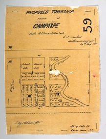 Bendigo Historical Society Inc.
Map - PROPOSED TOWNSHIP PARISH OF CAMPASPE, 24th May 1875
Map: Proposed Township, Parish of Campaspe(This has been crossed out and 'Creek View' written above). Hand Draughted Parish plan Stapled to the backingmap, township, proposed township, campaspe, creek view