Showing 4083 items matching "survey"
-
 Victorian Aboriginal Corporation for Languages
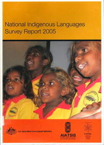
Book, Australian Institute of Aboriginal and Torres Strait Islander Studies, National Indigenous languages survey report 2005, 2005
The National Indigenous Languages Survey Report 2005 highlights that: of an original estimated 250 known Australian Indigenous languages, only 18 languages are now considered 'strong' and have speakers in all age groups; about 110 Indigenous languages are still spoken by older people but are endangered; words and phrases are still in use and there is community support in many parts of the country for reclamation and learning programs for many other languages which are no longer fully spoken; communities around Australia possess many of the elements required to keep Indigenous languages strong or to reclaim them. They have skilled and devoted language workers and teachers, excellent teaching materials, good documentation of languages and active community language centresmaps, colour photographs, tables, graphsaboriginal english, education, aiatsis, fatsil, language endangerment, language maintenance, language revival, language policy, language proficiency -
 Flagstaff Hill Maritime Museum and Village
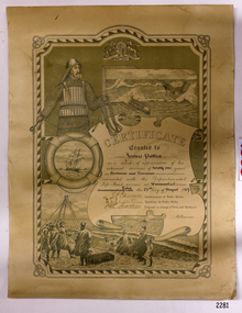
Award - Certificate of Service, F. W. Strahle, James Patten, 23-08-1907
This certificate acknowledges 21 years of service given by James Patten, one of the original 1859 Lifeboat Warrnambool as a boatman and bowman. At the time, all retiring Volunteer lifeboatmen were honoured with this award. It was made as a lithograph that was created by F. W. Strahle at the request of the Department of Lands & Survey, Melbourne, Victoria. During his time of service, James Patten was awarded a medal and certificate by the Royal Humane Society of Australasia for his bravery. Patten and his friend Joseph Lowe, who couldn't swim, were with their friend James Ferrier in a boat on the Hopkins River, Warrnambool, when their boat capsized. Ferrier made it to shore, and Patten tried unsuccessfully to hold onto Lowe and bring him to shore. The event occurred on 18th April 1890. The images on the Certificate show a collage of rescue events performed by the lifesavers; a shipwreck rescue in progress, lifeboat conveying five boatmen using two oars each, and a bowman standing at the bow, a linesman wearing a life jacket and holding a rescue line, a lifesaver ring with images of three sailing ships inside it, a shipwreck near shore, a woman and girl in shallow water, a rescue using a breeches buoy on the lifeline, two rescuers walking towards the survivor, rescue crew wearing waterproof clothing, a rocket machine with a pulley to bring the survivor in a breaches buoy to shore, and a rescue crew member holding a flare. Volunteers at the time received a small payment, or 'retainer'', for their practices and a payment of gratitude for the rescues they attended. Across the years between 1856 to 1979 the combined service in Victoria saved 260 lives. Amazingly, some of the volunteers could not even swim.This certificate shows the State and Local Government's appreciation for the years of service spent by in the endeavour to save lives in peril in and on the local waters in the early 20th Century. The lithographed design depicts the many skills and services performed by the lifesavers of the era.Certificate of Service, unframed, awarded to James Patten on 23rd August 1907, recognising his 21 years of service with the original Warrnambool Life Boat Service as a Boatman and Bowman. Certificate is on rectangular, cream paper, lithographed design, printed and handwritten. Letterhead with the Royal Coat of Arms of the United Kingdom and a French motto. Images depict lifesaving crew, lifeboat, rescue equipment and a rescue in progress. The border is waves inside of frame of looped rope. Signatures of Commissioner of Public Works, Secretary of Public Works, and Engineer in charge of Ports and Harbours, Melbourne. Printed from a lithograph produced by F.W. Strahle on 23rd June 1907.MOTTO: "Dieu Droit Et Mon, Ni Soit Qui Mal y" TREXT: "Certificate granted to James Patten as a mark of appreciation of his esteemed services of 21 years as Boatman and Bowman connected with the Departmental Life-Boat service at Warrnambool - dated the 23rd day of August 1907." SIGNATURES: [Commissioner of Public Works], [Secretary of Public Works], [Engineer in charge of Ports and Harbours Melbourne] "Lithographed at the Dept of Lands & Survey - Melb/ by F.W. Strahle, 23.6.07"flagstaff hill, warrnambool, flagstaff-hill, maritime museum, maritime village, shipwreck-coast, flagstaff hill maritime museum & village, james patten, life-saving, lifesaving, rescue, bravery, drowning, joseph lowe, james ferrier, hopkins river, boat accident, certificate of service, 1890, 1907, bowman, boatman, departmental life-boat service, life-boat service, lifeboat service, august 1907, commissioner of public works, public works, ports and harbours melbourne, lands & survey melbourne, f w strahle, lithograph, 1856-1979, 260 lives saved, victorian volunteers, lifeboatmen, retired lifeboatmen -
 Bendigo Historical Society Inc.
Book - FORTUNA COLLECTION: LANSELL'S FORTUNA
Produced by Army Survey Regiment, Bendigo. Describes grandeur of Fortuna and the vision and enterprise that saw the complex of mansion , gardens and mine buildings develop on the site. Twelve pagesArmy Survey Regimentbendigo, house, fortuna villa, fortuna, george lansell, ballerstedt, sandhurst, bendigo -
 Ringwood and District Historical Society
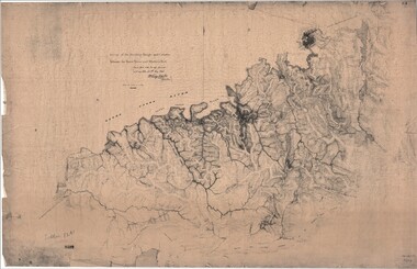
Map, Survey of Dividing Range between Yarra Yarra and Western Port - William Wedge Darke, 1843
Extract - Ringwood, Place of Many Eagles - Hugh Anderson (1974): William Wedge Darke, from Hereford, England, was a nephew of John Helder Wedge of the Port Phillip Association, who was also a surveyor. William's most important work was probably his survey of the Dividing Range and the country between the Yarra River and Western Port, completed in May 1843, and during which he made a traverse between the Mullum and Dandenong creeks along the higher ground that he labelled the "best line of road from Melbourne". This road was for many years the major route to Gippsland and to the higher country about Alexandra and Mansfield, sometimes known as White Horse Road, and now Maroondah Highway.Surveyor's relief map of features to the east of Melbourne including Yarra Yarra River, Mullum Mullum Creek, Anderson's Creek, Dandenong Creek.Transmitted to the Surveyor General with my letter of 10th May 1843 (signed) Wm Wedge Drake, Assistant Surveyor. Scale: two inches to a mile. Descriptive remarks include upstream area of Yarra River - "impassable, appears to have been formerly a lake", and to the south - "barren and scrubby swamps of the Western Port Country". Marked tracks include "best line of road from Melbourne", "track to Dandenong", "Road to Port Albert may probably be found on this range", "Best line to Upper Yarra". Several huts also marked. -
 Bendigo Military Museum
photograph - Fortuna - 1st Year of Army Occupation in Bendigo, 1942
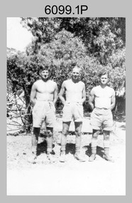
This is a set of 17 photographs taken during the first year of Army occupation at Fortuna, Bendigo in 1942. The photos provide an insight into the preparatory work performed on the Fortuna Villa and surrounding buildings, by the Working Party 5th Army Troop and Ordnance Training Depot, before its occupation by personnel from LHQ Cartographic Company, Royal Australian Survey Corps. The annotation on the back of Photos .9P and .10P is misspelt. The correct spelling is ‘Nell Gwynne’. The poppet head of the Central Nell Gwynne mine is still an iconic landmark in Bendigo, lying just down the road from the poppet head lookout at Victoria Hill. The Central Nell Gwynne was the premier mine of Bendigo's 1930s mining revival and is of high historical value, due to the extensive and relatively intact features which remain at the site. The annotation on the back of Photo .17P is incorrect. The location of HQ 5th Army Troop was ‘Reynard St, Coburg.’ By late 1941 as Japan extended its control throughout Indo-China, resolving the accommodation problem of AHQ Cartographic Company located in Melbourne became more urgent. The steady Japanese advance made the bombing of Melbourne no longer a remote possibility, and in accordance with a general policy of dispersion, the Deputy Chief of the General Staff, Major General Sidney Rowell instructed Major William Sarll, in the interests of security of plant and to provide against possible damage of air attack, to investigate suitable safer inland accommodation for AHQ Cartographic Company. Major Sarll inspected many properties before finding one that would meet the requirements of the Cartographic Company. In late 1941, he came to inspect Fortuna, a rambling old mansion with about fifteen acres of ground in central Bendigo. Initially there was no intention to occupy the site beyond the end of the war, although Major Sarll's report to the Director of Survey noted many advantages in moving the Company to Bendigo. Major General Rowell quickly approved the selection of Fortuna before other authorities, which were investigating the evacuation of school children, could get in ahead of the Cartographic Company. On 23 March 1942, the Commonwealth of Australia, under the provisions of the National Security Act of 1939, took possession of the house, the old battery buildings and the fifteen acres of grounds. Under Warrant Officer J. Trist’s direction, over fifty Parks and Works tradesmen completed building works necessary to accommodate the Survey Corps’ military, map making and printing requirements. The building program was still under way when the first officer, Lieutenant Ralph Westgarth, arrived in May 1942 with the advance party which received and positioned all equipment as it came up from Melbourne in semi-trailers. Once the equipment was installed the rest of the Cartographic Company completed its shift to Bendigo by 11th June 1942. The first year of the Survey Corps’ occupation of Fortuna is covered in more detail with additional historic photographs, in pages 17-22 of Valerie Lovejoy’s book 'Mapmakers of Fortuna – A history of the Army Survey Regiment’ ISBN: 0-646-42120-4.This is a set of 17 photographs taken during the first year of Army Occupation at Fortuna, Bendigo in 1942. The black and white photographs were printed on photographic paper and are part of the Army Survey Regiment’s Collection. The photographs were scanned at 300 dpi. .1) - Photo, black & white, 1942. Bendigo Parks and Works tradesmen at Fortuna. L to R: Cliff Day, Ernie Arnold, Norm? .2) - Photo, black & white, 1942. “Don” - possibly SGT Don Sutcliffe. Fortuna, Bendigo. .3) - Photo, black & white, 1942. Parks and Works tradesmen in garden at Fortuna, Bendigo. L to R: Fred & Ernie. .4) - Photo, black & white, 1942. Benny Jack Williams at Fortuna, Bendigo. Accommodation tents were erected above the lake, which later became the parade ground. .5) - Photo, black & white, 1942. Working dress - Giggle suits. Parks and Works tradesmen at Fortuna, Bendigo. L to R: Cliff and Harry on big roof. .6) - Photo, black & white, 1942. Parks and Works tradesmen at Fortuna, Bendigo. Ted on big roof. .7) - Photo, black & white, 1942. Gold crusher battery just behind Fortuna. .8) - Photo, black & white, 1942. Scene of Bendigo from Fortuna. .9) - Photo, black & white, 1942. Nell Gwynne Mine from mullock heap at Victoria Hill near Fortuna, Bendigo. .10) - Photo, black & white, 1942. Nell Gwynne Mine and crusher near Fortuna, Bendigo. .11) - Photo, black & white, 1942. Sluicing for gold at Eaglehawk. .12) - Photo, black & white, 1942. Fortuna, Bendigo taken from the far side of tennis courts. .13) - Photo, black & white, 1942. Fortuna, Bendigo & its reflection from across the lake. .14) - Photo, black & white, 1942. Fortuna, Bendigo from the fishpond. .15) - Photo, black & white, 1942. Fortuna, Bendigo. .16) - Photo, black & white, 1942. First Fortuna Football Team at unknown location. L to R: 5th Bob Wright, 11th SGT Don Sutcliffe. .17) - Photo, black & white, 1942. Working Party from 5th Army Troop and Ordnance Training Depot at Fortuna, Bendigo.Some personnel are identified. Annotated with date within photos. .1) – Annotated on back ‘Cliff, Ernie, Norm, Dec ‘42. Cliff Day - dairy farmer, plasterers’ labourer. Ernie Arnold – hard plasterer. Norm? - QM Store for tools etc. QM Store was the Stables.’ .2) - Annotated on back ‘Don. Fortuna 1942’ .3) - Annotated on back ‘Fred & Ernie. Dec 1942. Carpenters. Note the state of the gardens.’ .4) - Annotated on back ‘Benny Jack Williams Fortuna Bendigo. Tents were erected where present day parade ground is above the lake.’ .5) - Annotated on back ‘Working dress - Giggle suits. June 42. Cliff and Harry on big roof. This photo was taken as the ventilating ridge was being installed on the building housing the printing machines. The machines were installed later by civilian labour when building was complete.’ .6) - Annotated on back ‘Ted on big roof Fortuna Bendigo.’ .7) - Annotated on back ‘Gold crusher battery – Bendigo for slay heap – 1942. 12 stamp battery. Just behind Fortuna. Was working at night when the “Army” came to Bendigo. Later removed to “Coolgardie - WA. Present site of Southern Cross TV.’ .8) - Annotated on back ‘Scene of Bendigo from Fortuna. June 1942.’ .9) - Annotated on back ‘Nell Gwyne Mine from mullock heap (Victoria Hill) Sept 1942.’ .10) - Annotated on back ‘Nell Gwyne Mine and crusher September 1942.’ .11) - Annotated on back ‘Sluicing for gold at Eaglehawk. August 1942.’ .12) - Annotated on back ‘Fortuna Bendigo 1942. Taken from far side of tennis courts.’ .13) - Annotated on back ‘ “Fortuna” across the lake & reflection.’ .14) - Annotated on back ‘Fortuna from fishpond June 1942.’ .15) - Annotated on back ‘Fortuna Dec 1942.’ .16) - Annotated on front ‘X’ x2. Annotated on back First Fortuna Football Team 1942‘Bob Wright’, ‘SGT Don Sutcliffe’. .17) - Annotated ‘Working Party at Fortuna before one of the drafts’, Working Party 5th Army Troop and Ordnance Training Depot Showgrounds, now the Sportsground Bendigo’, ‘HQ of 5th Army Troop was Reynards Rd, Coburg.’royal australian survey corps, rasvy, army survey regiment, army svy regt, fortuna, asr -
 Bendigo Military Museum
Administrative record - Royal Australian Survey Corps Miscellaneous Documents Volume 57, Army Works Development Committee, Royal Australian Survey Corps Miscellaneous Documents Volume 57, 1967 1969, Item #18 1947
Sleeve #1 " Percentage of ARA recruits allocated to RA Svy entering 1 RTB having obtained leaving certificate or better education standard." Sleeve #2 "Report of Review Committee on RA Svy 17 Feb 1969." Sleeve #3 " Recommendation of the forming of the Army Mapping and Charting centre at Bonegilla." Sleeve #4 "Comparison Charts" "RA Svy Strength / Establishment 1960 - 1968." Top LHS. "3.134.4" Top RHS. Sleeve #5 "Report of RA Svy Review Committee. Recomends the forming of 2,4 and 5 Fd Svy Sqns and adding 8 Fd Svy Sqn to the Order of Battle" Sleeve #6 " Letter and Report as part of Review dealing with manpower." Sleeve #7 "AEC" 15 Oct 1969 Sleeve #8 "17 Sep 1969" Sleeve #9 "18 Dec 68" "3.134.2" Sleeve #10 "3.134.4" Sleeve #11 "12 Mar 69" 3.134.4" Sleeve #12 "10 Jun 69" "3.134,4" Sleeve #13 "Terms of Reference - Review Committee" Sleeve #14 "5 Feb 68" Sleeve #15 "Relocating Svy Regt at Bonegilla, Proposed Mapping Centre in Canberra" Sleeve #16 Comparison of rate of growth of ARA with RASvy Sleeve #17 A detailed analysis of RASvy's role by sub unit including overseas agencies. There is also a document describing the various Survey Trades. Sleeve #18 Letter from disgruntled farmer re damage to his property. "1947"Hard covered folder, White, 4 ring binder, 18 plastic A4 sleeves, Numbered 1 - 18Sleeve #1 : ''Education Standards of Recruits", top of page in centre, 3.134.4 Sleeve #2 : "17 Feb 1969" Top of page centre." Sleeve #3 : "3.134.4" Top right hand corner." Sleeve #5 : "3.134.4" Top of page. "75087" Top right hand corner." Sleeve #6 : "20 May 1969" Top of page centre. "3.134.4'' Top right hand corner." Sleeve #7: "AEC" "15 October 1969" Upper right hand side." Sleeve #8: "17 September 1969" Near top of page centred." Sleeve #9: "18 Dec 68", "'3.134.2" Top of page." Sleeve #10 ''3.134.4'' Top right hand corner." Sleeve #11 ''12 Mar 69'' Near top page centred. ''3.134.4'' Near top right hand corner." Sleeve #12 ''3.134.4'' Top right hand corner. ''10 Jun 1969'' Upper right hand side." Sleeve #13 ''Terms of reference - Review committee'' near top of page centred." Sleeve #14 ''5 Feb 1968''Lower left hand side. ''1968 circled'' Lower right hand side." Sleeve #15 "Relocating Svy Regt at Bonegilla Proposed mapping centre in Canberra." Sleeve # 16 "Comparison of rate of growth ARA with RA Svy," Sleeve #17 "A detailed analysis of RA Svy's role by sub unit including overseas agencies. Ther is also a document describing the various Survey trades." Sleeve #18 "Letter from disgruntled farmer re damage to his property." "1947" " centre top of page."royal australian survey corps, fortuna, army survey regt, army svy regt, asr, rasvy -
 Anglesea and District Historical Society
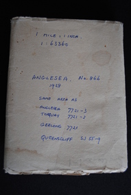
Map, Royal Australian Survey Corps, Anglesea, Victoria, 1954
Anglesea, Victoria [cartographic material] produced by Royal Australian Survey Corps. Colour; Scale [1:63,360] 1 mile to 1 inch; transverse Mercator projection; Sheet No. 866, Zone 7. Two stamps: 1. Rankine and Dobbie Pty Ltd. 2. Authorised for sale / Price 2/- / By Department of the Army Original date: November 1928.(See above)anglesea map, topographic map -
Clunes Museum
Document (Item), DEPARTMENT OF LANDS AND SURVEY, RENEWALS GARDEN LICENCE 5/
RECEIPT BOOK DEPARTMENT OF LANDS AND SURVEY. LICENCE TO ENTER UPON CROWN LANDS NOT EXCEEDING IN AREA ONE ACRE, AS SPECIFIED HEREUNDER, FOR PURPOSES OF GARDEN AND RESIDENCE. FEE PER ANNUM 5 / O (FIVE SHILLINGS) FIFTY CENTSlocal history, local government, council, licence, garden -
 Glenelg Shire Council Cultural Collection
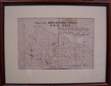
Map - Map of Drik-Drik, 1865
Displayed at History House.Print of map pasted onto board, mounted and framed under glass. Buff-coloured mount. Mahogany stained moulded wood frame, black inner frame.Front: Plan of the Agricultural Area of Drik-Drik L.2556/Prepared by the Board of Lands and Works in accordance with the "Amending Land Act 1865". Lands and Survey Office, Melbourne 11th May 1865. (printed, upper centre). Back: Duncan Hedditchmap, drik drik, plan, geography, cartography -
Federation University Historical Collection
Formulae Mine Surveying
Formulae for the various calculations involved in Mining Surveying - areas, volumes, weights, chain strength, loads, Columns, angles, side lengthsmine surveying, survey -
 Bendigo Historical Society Inc.
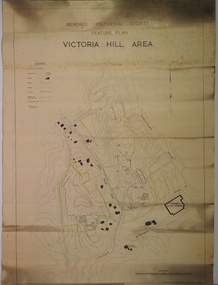
Plan - JAMES LERK COLLECTION: BENDIGO HISTORIC SOCIETY FEATURE PLAN OF VICTORIA HILL AREA COMPILED BY AHQ SURVEY REGIMENT MAY 1971
BHS CollectionPaper plan produced for the Bendigo Historic Society Victoria Hill Area Compiled by AHQ Survey Regiment May 1971 plan with black print, has been rolledAHQ Survey regiment -
 Bendigo Military Museum
Photograph - AHQ Survey Regiment - LTCOL DR Ridge and SSGT G Haswell Circa 1972-1975, 1975
Photograph taken in the Sergeants Mess, Fortuna Villa circa 1972-1975 whilst LTCOL DR Ridge was the Commanding Officer of the Army Survey Regiment and SSGT G Haswell was a stores NCO. WO2 Szentirmay (in the background) was a Lithographic Technical Warrant Officer. 4233 LTCOL DR Ridge was commissioned from the ranks and served from 1946 - 1975, he was Commanding Officer of the Army Survey Regiment from 1972-1975. 310207 SSGT G Haswell served 1950- 1978 after a British Army career, 14613 WO2 T Szentirmay BEM served 1958-1980 after an Eastern European Army career.Black and White photograph of LTCOL DR Ridge and SSGT G Haswell Circa 1972-1975 taken at the Sergeants Mess at Fortuna Villa, Bendigoroyal australian survey corps, rasvy, fortuna, army survey regiment, army svy regt, asr -
Glenelg Shire Council Cultural Collection
Photograph - Photograph - aerial view of railway between Heywood and Rennick, 03/05/1952
Black and white aerial photographs (aerial survey record print) of the railway line between Heywood and Rennick (S.A. border) Taken for Victorian Railways, May 1952. Some photos have annotations later added to the front of the image in penVictorian Railways aerial survey record print of the railway line between Heywood and Rennick (S.A. border) Black and white, white vertical strip on imageBack: 'Heywood - Rennick 21389 - 19660 261m 3c ' - all black ink. Purple VR aerial survey stamp. '3 May 1952' - black stampvictorian railways, train track, transport -
Glenelg Shire Council Cultural Collection
Photograph - Photograph - aerial view of train track between Heywood and Rennick, 03/05/1952
Black and white aerial photographs (aerial survey record print) of the railway line between Heywood and Rennick (S.A. border) Taken for Victorian Railways, May 1952. Some photos have annotations later added to the front of the image in penVictorian Railways aerial survey record print of the railway line between Heywood and Rennick (S.A. border) Black and white, white vertical strip on imageBack: 'Heywood - Rennick 21453 - 19724 267m 19c ' - all black ink. Purple VR aerial survey stamp. '3 May 1952' - black stampvictorian railways, train track, transport, travel -
 Bayside Gallery - Bayside City Council Art & Heritage Collection
Map, Department of Crown Lands and Survey et al, Moorabbin, County of Bourke, Government Roads, 1920
The cadastral map of the Parish of Moorabbin in Victoria (L.6104) shows parish boundaries and land ownership 1920 when Sandringham was a Town. The government roads have been coloured in red pencil.moorabbin, county of bourke, map, plan, land subdivision, land titles, foreshores, hampton, beaumaris, highett, cheltenham, department of lands and survey, land owners, cartographic material, brighton, sandringham, town of sandringham, government roads -
 Bayside Gallery - Bayside City Council Art & Heritage Collection
Map, Department of Lands and Survey, Land under the control of the City of Sandringham, 1962
The cadastral map showing land under the control of the City of Brighton in 1962.map, plan, foreshores, sndringham, hampton, beaumaris, cheltenham, department of lands and survey, cartographic material, moorabbin, black rock, street map, city of sandringham, board of lands and works -
 Bendigo Military Museum
Administrative record - Royal Australian Survey Corps - Operation Tropic Shores, 1 Field Survey Squadron 1978, 31 Aug 1978
Operation Tropic Shores was conducted in 2 phases, Sep 1977 and May / Jun 78. The Operation was the field completion of Cape York 1;50,000 Mapping North of latitude 15 degrees S. Plotting was undertaken by 2, 4 and 5 Fd Svy Sqns with 1Fd Svy Sqn undertaking the mounting and Management of the field completion phase. Re-visiting and targeting of existing trig stations was also carried out as an opportunity task.Booklet, A4 cream cardboard cover, stapled Left Hand side, containing a report and plotted maps. Cover has Title and the Badges of the Australian Army Corps who participated in the Operation. 2 fd svy sqn, 4 fd svy sqn, 5 fd svy sqn, royal australian survey corps, 1 field survey squadron, 1fd svy sqn, rasvy, fortuna, army survey regiment, army svy regt, asr -
 Bendigo Military Museum
Administrative record - Royal Australian Survey Corps Report on Operation Aright 85 / 86 1 Field Survey Squadron 1986, 1986
Operation ARIGHT 85 was mounted by 1 Fd Svy Sqn 14 May to 8 Aug 1985 and 1 May to 15 May 1986. In the 1:250,000 SG54-15 Rutland Plains map area. In addition 18 X 1:50 000 maps were field completed.6359.1 Copy 1. 6359.2 Copy 2. A4 Cardboard cover, grey, plastic ring binder, report, diagrams, maps, plastic ring binder.royal australian survey corps, 1 field survey squadron, 1fd svy sqn, rasvy, fortuna, army survey regiment, army svy regt, asr -
Moorabbin Air Museum
Newspaper (item) - Aviation - A Survey By Peter Finn - A survey by The Australian Tuesday March 2 1971
-
 Beechworth Honey Archive
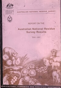
Publication, Australian National Residue Survey - Report on the Australian National Residue Survey Results 2001-2002 (Dep of Agriculture Fisheries & Forestry), 2002
Soft cover book slightly larger than A5 siz, green spine with an off white cover with pencil drawings of cattle sheep, pig. seafood, chicken, eggs, sunflowers & wheat 93 pages -
 Beechworth Honey Archive
Publication, Australian National Residue Survey - Report on the Australian National Residue Survey Results 2000-2001 ( Dept of Agriculture, Fisheries and Forestry - Australia), 2001
Soft Cover book slightly larger than A5 size, Dark Green spine with an off white cover & pencil drawings of a pig, fruit, seafood, chickens, eggs,sunflower grain, cattle, sheep 74 pages -
 Bendigo Historical Society Inc.
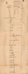
Document - VIRGINIA MINE
Transverse section of the Virginia mine on the Garden Gully line of Reef at Eaglehawk, being Plate V of Bulletin No. 47 from the Geological Survey Office at BendigoGeological Survey Office Bendigogold, goldfields, virginia mine, gold mines, garden gully line of reef, virginia mine , eaglehawk -
 City of Moorabbin Historical Society (Operating the Box Cottage Museum)
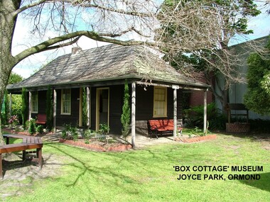
Photograph - ' Box Cottage' Reconstruction, c1841
The original small, pioneer cottage was built in the late 1840s to early1850s, by an unknown pioneer. It was located on part of a 30 Acre allotment that was originally part of Henry Dendy’s Special Survey granted in 1841. The doors and window sashes, (made of red deal joinery timber), as well as the brass locks and fittings, are from the original cottage, and were imported from England.The fire-place bricks are from the original cottage, and are sun-dried, (not kiln fired), and are hand-made. Convict marks can be seen on two bricks.There is a small display of external cladding shingles from the original pioneer cottage. These shingles were hand-split, and most likely made from locally collected timber The nails included in this display were used to fasten the shingles on the original cottage, and are also hand-made. The enamel nameplate, “Colonial”, on the wall of the cottage, was the name chosen for the original pioneer cottage when a later owner, Mr August Rietman and wife Frieda leased the property in around 1917. August purchased the property 1935 for 1200 Pounds approximately and resided there until 1953. In 1974 Mr Lewis, a timber specialist, found the dilapidated building on property he had recently purchased in Jasper Rd and suggested it be reconstructed and relocated. Moorabbin Council agreed and the Cottage was rebuilt just about 250 metres from its original site. The cost of the rebuild was met by 'Victoria's 150th Committee, plus a small grant from the City of Moorabbin, and Mr Laurie Lewis donated much of the timber for the reconstruction. Although 'Box Cottage' is a re-construction, it is an unique museum that, being located in the midst of a modern community in Ormond Victoria, can educate and demonstrate many aspects of the early settler’s way of life in Victoria. As such, it is an invaluable resource for students and all kinds of visitors. The original small, pioneer cottage was built in the late 1840s to1850s, by an unknown pioneer. It was located on part of a 30 Acre allotment that was originally part of Dendy’s Special Survey granted in 1841. The re-constructed pioneer cottage, named ‘Box Cottage’, is located only a matter of metres from the original pioneer cottage site, in Joyce Park, Jasper Road, Ormond, Victoria. The museum has copies of interesting Land Titles associated with the surrounding land, including the site of the original pioneer cottage, from Dendy’s time, and into the 1900s. ‘Box Cottage’ is named after the pioneers, William and Elizabeth Box, who resided in the original cottage from approximately 1865, until Elizabeth’s death in 1914.The re-constructed cottage plan has followed faithfully the original dimensions, and plan of the original pioneer cottage, and as many original items from that cottage’s long occupation have been incorporated. Convict marks on sun -dried, fire-place chimney bricks. Enamel nameplate 'Colonial' circa1915brighton, moorabbin, cottages, pioneers, ormond, colonial, mckinnon, dendy henry, box william, box elizabeth, convicts, rietman august, rietman frieda, rietman stefanie -
 City of Greater Bendigo - Civic Collection
Administrative record - Land Sales, Department of Lands and Survey et al, 1929
This type of album was created by agents auctioning and selling land.Large portfolio style album with green cloth cover bound with three large metal pins. One hundred and then pages with thirty three Department of Lands and Survey maps pasted in. Index page. Maps have handwritten notes and markings throughout in pencil and pen. Covers the Counties of Bendigo, Rodney, Talbot, Gunbower, Gladstone, Tatchera and Karkarooc, Shires of East Loddon and Huntly and Swan Hill District. -
Clunes Museum
Administrative record - BOOK, DEPARTMENT OF LANDS AND SURVEY, LICENCE
RECEIPTS ISSUED BY DEPARTMENT OF LANDS AND SURVEY TO CUT AND TAKE AWAY WOOD. ISSUED EACH QUARTER. LOCALITY - ALL CROWN LANDS, NOT BEING IN STATE FORESTS OR RESERVES FOR ANY SPECIAL PURPOSE. GUM, STRINGYBARK, BOX, MESSMATE AND OTHER KINDS OF EUCALYPTUS TIMBER EXCEPTING RED GUM AND IRON BARK.BLUE CARDBOARD COVERED BOOK CONTAINING TIMBER LICENCES FOR ORDINARY WOOD, COSTING 5/- .1 ISSUED 1886 - 1887 RECEIPT NUMBERS 181901 - 181925 .2 ISSUED 1885 - 1886 RECEIPT NUMBERS 185276 - 185300 DETAILS OF NAMES OF PERSONS LICENCES ISSUED TO ATTACHED TO BACK OF BOOKSlocal history, receipt books, early citizens, wood licences -
 Department of Energy, Environment and Climate Action
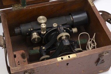
Telescope in wooden box
used for surveyingTelescope used for surveyingStanleyforests commission victoria (fcv), forest measurement, surveying -
 Bendigo Military Museum
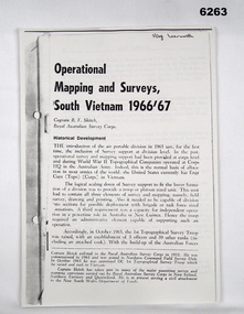
Booklet - Operational Mapping and Surveys - South Vietnam 1966/67, Royal Australian Survey Corps
Report written for the "Australian?" Army Journal. This report describes in some detail the Australian 1st Topographical Survey Troop from its initial formation in Oct 1965 through its deployment to South Vietnam in May 1966 and its Operational activities during 1966/67 in support of the 1st Australian Task Force.A4 booklet, stapled in top left corner. "SSgt Learmonth" written on front cover.royal australian survey corps, rasvy, fortuna, army survey regiment, army svy regt, asr, 1st topographical survey troop, south vietnam -
 Bendigo Military Museum
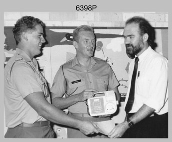
Photograph - 2 FD Svy Sqn Childrens Hospital Charity Presentation, Sydney, NSW, 1989
This photograph of a charity donation from 2 FD Svy Sqn to the Director of the Prince of Wales Childrens Hospital, was taken in Sydney in 1989. CPL Bob Hopper and SPR Bob White presented a Kangaroo Pump, used for feeding sick children to the Director that was purchased with leftover Regimental funds when the unit closed down. This photograph of a charity donation from member of 2 FD Svy Sqn to the Director of the Prince of Wales Childrens Hospital was taken in Sydney in 1989. The black & white photograph was printed on photographic paper and is part of the Army Survey Regiment’s Collection. The photograph was scanned at 300 dpi. .1) - Photo, black & white, 1989. L to R: SPR Bob White, CPL Bob Hopper, Director of the Prince of Wales Childrens Hospital..1P – annotated in red pen ‘2 Fd, presenting the Director of the Prince of Wales Childrens’ Hospital with a Kangaroo Pump, used for feeding sick children. The pump was purchased with leftover Regimental funds when the unit closed down.’royal australian survey corps, rasvy, army survey regiment, army svy regt, 2 fd svy sqn -
 Wannon Water
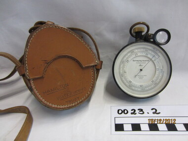
Aneroid, ER Watts & Son
Possibly used for surveying pipe linesSurveying Aneroid Compensated -
 Federation University Historical Collection
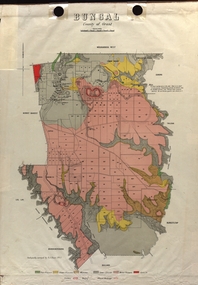
Map - Plan, E.J. Dunn, Bungal County of Grant Parish Plan
E.J. Dunn was the surveyor of this parish plan.Colour geological plan of Bungal in the County of Grant, Victoria. The areas circled in red ar craters.plan, bungal, bungeltap, black horse co. egerton, egerton, mount egerton, sister rose shaft, south learmonth co, kerrit bareet, bungaeeltap, yaloak, eastern moorabool river, corong, bungal station preemptive right, lal lal, western moorabool river, moorabool rover, borhoneychurck, mount egerton battery, bungal creek