Showing 2653 items
matching victoria hall
-
 Halls Gap & Grampians Historical Society
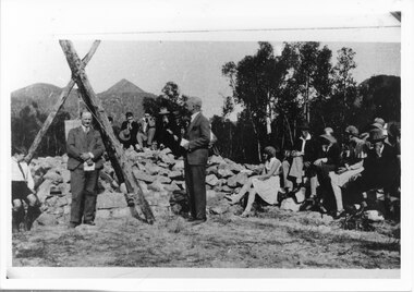
Photograph - B/W, 14/04/1931
The photo shows the opening ceremony of Henham Township by Lord Stradbroke (the man on the right of the structure). A strip of land 2 kilometres long and half a kilometre wide had been approved as suitable for subdivision into 591 quarter acre blocks valued at 30-35 pounds each. Unfortunately it turned out to be a "fizzer". For further information see Victoria's Wonderland pp 93-95, 103.Photo shows a group of people sitting on and standing behind a low pile of rocks that sweeps around a wooden structure, which is three rough logs standing and lashed together to form a rough pyramid. A pulley is attached to the apex of the pyramid and a large stone block is suspended from it. Two men stand, one in front of and one beside the structure, both wear suits and are holding pieces of paper. A young boy sits in the left foreground in front of one of the poles.events, ceremonies -
 Halls Gap & Grampians Historical Society
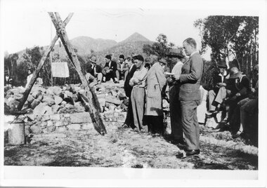
Photograph - B/W, 14/04/1931
The photo shows the opening ceremony of Henham Township by Lord Stradbroke (the man on the right of the structure). A strip of land 2 kilometres long and half a kilometre wide had been approved as suitable for subdivision into 591 quarter acre blocks valued at 30-35 pounds each. Unfortunately it turned out to be a "fizzer". For further information see Victoria's Wonderland pp 93-95, 103.`Photo shows five men, middle foreground all standing, with others seated and standing in the background. The man stranding closest to the camera is holding a piece of paper in his hand. A rock pile and low stone fence can be seen middle foreground. A pulley is attached to a tripod of tree posts and is holding up a large cut stone. Mountains are visible in the background.events, ceremonies -
 Halls Gap & Grampians Historical Society
Newspaper - B/W, C 24/11/2000
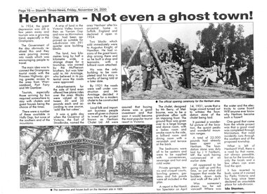
An article describing the Henham Township project as well as the Knight Family Tearooms built on the Henham site in 1925. For further info see "Victoria's Wonderland" pp 93-95, 103.A newpaper article from "The Stawell Times" , "Halls Gap Extra" Supplement of 24 November 2000, page 16, entitled Henham v- Not even a ghost town!townships, henham -
 Halls Gap & Grampians Historical Society
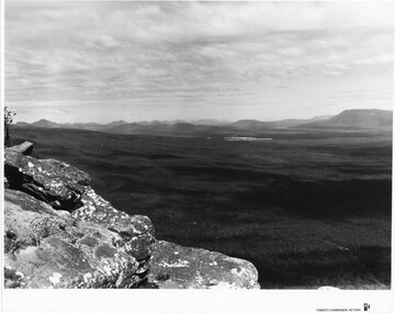
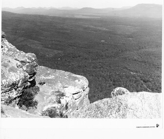
Photograph - B/W
Viewing area is known as The Balconies overlooking Victoria Valley. Photo is typical of tourism photos taken by the Victorian Railways during this period. c1950 -60'sa group of people (17) standing on a rocky ledge overlooking a treed valley. a second rock ledge is above them creating the impression of a large mouth. Printed on back: Copyright Photograph. This photograph may be reproduced on condition that it is acknowledged a s 'VICTORIAN RAILWAYS PHOTOGRAPH'. P3465 written faintly in pencil. The Balconies Halls Gap written in blue penscenery, lookouts -
 Halls Gap & Grampians Historical Society
Photograph - B/W
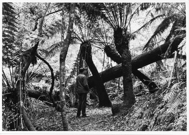
Typical of promotional photos taken by Forestry Commission VictoriaMan facing away from camera, on walking track, looking at large fallen tree trunk. He is surrounded by very tall tree ferns.Forests Commission, Victoria and picture logo printed in R/H white border LC.32 written on backscenery, walkers -
 Halls Gap & Grampians Historical Society
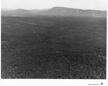
Photograph - B/W
Photo is of Moora Moora in the Victorian Valley. Typical of the time as a promotional image taken by Forests Commission Victoria.View over a large Valley with ranges in the distance. Roads through the valley are visible and a body of water in the middle right of the photograph. A rocky outcrop is in the left side foreground.Publicity & Public Relations Branch. When reproducing please acknowledge Forests Commission Victoria Negative no. 322-26scenery, grampians ranges -
 Halls Gap & Grampians Historical Society
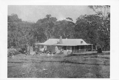
Photograph - Photocopy
This house belonged to Walter Zumstein of the Zumsteins area. The house was burnt down in 1938. Photo was taken by Stan Parfett whose own family camped in the Zumstein area and knew Mr and Mrs Zumstein personally. c1920's This is an photocopied enlargement from a photocopied magazine article, Victoria's Heritage (see item 637)A house with veranda. A chimney (stone?) protrudes from roof at front. cleared land in foreground with old style wooden fence visible. A tank and stand situated beside house at front. Thick trees /Bush behind house.House Burnt 1938. Walter Zumstein's house. Photo by Stan Parfett. written on back.buildings, houses -
 Halls Gap & Grampians Historical Society
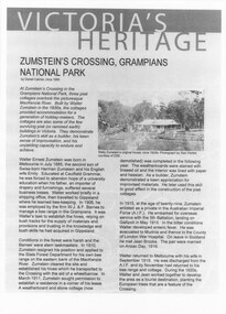
Document - Article (magazine/newspaper)
Article (3pages) written by David Catrice for Parks Victoria. More history on Walter Zumstein and the Zumstein area can be found on p137, 153 -156, 83, 107, 136 of "Victoria's Wonderland: a Grampians History"3page Article describes Walter Zumstein and the area known as 'Zumstein's'. Entitled Zumstein's Crossing, Grampians National Park from "Victoria's Heritage", Parks Victoria c1995media, magazine articles -
 Halls Gap & Grampians Historical Society
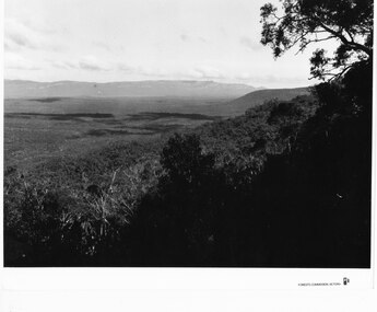
Photograph - B/W
Photo is of the "Victoria Valley" taken from around the area of Reed's Lookout. The body of water is Moora Moora Reservoir. The background range is Victoria Range. Photo is typical of promotional photos taken by Forests Commission VictoriaRocky outcrop in foreground and a large, thick tree covered valley, with mountain ranges in the background. A body of water (near top, middle) and some roads can be seen c1960sscenery, grampians ranges -
 Halls Gap & Grampians Historical Society
Photograph - B/W
Photo is of Victoria Valley with Moora Moora Reservoir and the Victoria Range in the background. Photo would have been taken from around Reed's lookout area. Photo typical of promotional photos of the time by Forests CommissionLarge, densely treed valley with a body of water in background. Some roads can be seen particularly right foreground. There is a mountain range in the background. c1960sscenery, grampians ranges -
 Halls Gap & Grampians Historical Society
Photograph - B/W
Photo is of Victoria Valley with the Victoria Range in the background. Photo is typical of promotional photographs taken by Forests Commission at that time.a thick bush covered valley in foreground (shadowed). Mountain range in background. Photographed from a high spot looking down and across the valley. c1960sscenery, grampians ranges -
 Halls Gap & Grampians Historical Society
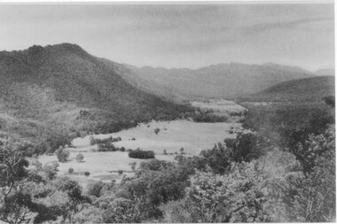
Photograph, C 1940 -50s
Valley is now known as Fyans Valley but in the 1840-50s it was called Lady Mary's Vale. See p. 111 of 'Victoria's Wonderland' for historical information.A valley with a cleared area stretching along the valley floor. A mountain range runs along the left and into the distance of the photograph. a rocky outcrop, bushes and trees appear in the front and right of the photo. c 1940-1950sscenery, fyans valley -
 Halls Gap & Grampians Historical Society
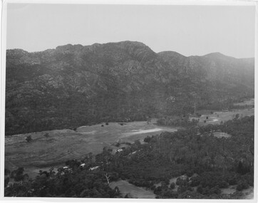
Photograph
Photo depicts Fyans Valley. The road is The Grampians/ Dunkeld Road, leading to Dunkeld towards the right or Halls Gap travelling towards the left. Fyans Creek is visible in parts at the foot of the range (middle of Photo). Photo appears to have been taken from Bellfield Pk area. Photo is typical of those taken by Forests Commission of Victoria in the 1960sPhoto shows a mountain range in the background with a valley. The Valley has a band of a mostly cleared grassy section (middle of photo) with a fairly dense treed area in the foreground. A road and some buildings can be seen where the cleared land meets the treed area.scenery, fyans valley -
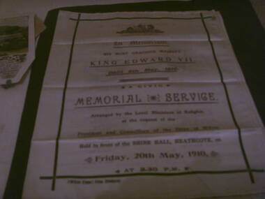 Heathcote McIvor Historical Society
Memorial booklet, shire of mcivor, minsiters of religion, Silk Memorial Booklet Death of King Edward VII 6 May 1910, 06/05/1910-20/05/1910
Created for the memorial service that was held on friday 20th may 1910, held in front of the shire hall in Heathcote to honour king edward VII who died on the 6th may 1910 at 2.30 p.m. this was arranged by the local ministers of religion at the request of the president and councillers of the shire of McIvor.Believed to be the only one in exsistence, after intesive research have been unable to come up with any information, from the shire, local churches or senior members of the community,only mention was in the Bendigo Advertiser newspaper.research in to archives further afield have not produced another.Piece of cream silk printed on face and inside, screen printed in purple and black ink on front and inside the order of service. details of all ministers of religion and shire dignitries as well as hyms sung. "McIvor Times" Print, Heathcote on left hand side below main print. in black inkvictoria, silk memorial booklet, king edward vii, 1910, heathcote, ministers, of, local, churches, shire, president, mcivor, times -
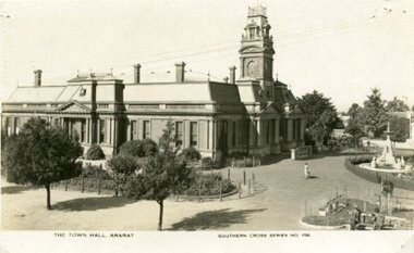 Ararat & District Historical Society (operating the Langi Morgala Museum)
Postcard
... Stereograph Co Armadale, Victoria The Town Hall Ararat, Souther Cross ...Part of the Rose Stereograph Co Armadale, VictoriaBlack and white postcard of Ararat Town Hall taken from a high position on the Vincent Street side of the building. A fountain can be seen on the right and there are two garden beds. A woman is walking on a path between the Town Hall and fountain.The Town Hall Ararat, Souther Cross Series 156 -
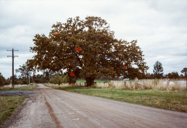 Eltham District Historical Society Inc
Photograph, Donaldson Oak, Donaldson Road, Kangaroo Ground, 1986, 1986
Used for the Society's Banner project. [note written by Joy Ness, "View Hill", Kangaroo Ground, 11 June 1986:] In 1878 while on a trip to Scotland and England, John Donaldson visited Windsor Castle Park, where he collected some acorns which he brought back to Australia, to his property, "Kangaroo Hall" at Kangaroo Ground. He and his son John Anstruther Davidson Donaldson, who was then 10 years old, planted one near the present Donaldson's Lane, in 1878. This is now a very fine tree, 108 years old. This information comes from Miss Victoria Donaldson, daughter of John Anstruther Davidson Donaldson. Miss Donaldson suggests that Wippell's Oak at Kangaroo Ground may also have been grown from one of the same Windsor Park acorns.Colour photographactivities, banner project, donaldsons oak, john anstruther davidson donaldson, kangaroo ground, significant trees, william donaldson -
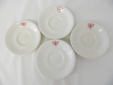
 Kiewa Valley Historical Society
Saucer Ceramic, circa 1940's to 1950's
This item was used by the State Electricity Commission of Victoria in their mess rooms for their workers during the construction of the Kiewa Hydro Electricity Scheme. The imprint of the year "1921" was to identify the year that the SECV was formed and relieved the private VHEC (Victorian Hydro-Electric Company). As the scheme was of such a huge, isolated and time consuming nature the feeding of its workers was quite demanding of cutlery and crockery. The use of sturdy English cups and saucers was essential. The period of construction and the isolation of the Kiewa Valley area placed heavy demand for "solid" crockery that could wear abusive handling. This period in time was one when crockery, whether for domestic or commercial use, was imported from "mother" England. This scenario was more so for governmental bodies such as rail, jails and electricity providers than domestic users. The influx of cheaper Asian crockery had not yet begun.This type of crockery item was used by the thousands of SEC Victorian staff and construction workers involved in the building of the Kiewa Hydro Electricity Scheme, over the extensive period (1938 to 1961). This was a period when Government bodies and other semi- government organisations were still tied to the "establishments" of "mother" England. It was a period in Australia's development when the Asian influence was very weak and the established ties to England and Europe was still very strong. The majority of heavy equipment and machinery was either made in England or Europe. Local/European expertise in dam construction and water management in alpine terrain came from migrants or specially recruited English and Europe specialists. The quality of workmanship from big steel manufacturing plants in England and Europe could not be matched from anywhere else in the developed world.This item is a white ceramic State Electricity Commission Of Victoria saucer (tea /coffee). It is made in England and is of strong and durable ceramic. The bottom cup indent is for either tea or coffee cups of a similar ceramic structure. The 5mm thickness of the ceramic suggests this saucer belongs to a commercial kitchen environment and not domestic. The indent bottom of the saucer is 5mm deep with a side curvature ratio of 2:5. The ceramic is glazed to a commercial standard (worker's mess). See also KVHS 0128 (B to D)The seal of the State Electricity Commission Of Victoria is imprinted on the top inside rim within a curved scroll. Snuggled within the borders of the scroll is a banner with the five stars of the southern cross and an arm with a closed fist projecting from the top with five lightning bolts projecting outwards. On the underside "Vitrified sold by Cafe & Hotel Supplies Pty Ltd Dunn Bennett & Co. Ltd. Burslem Made in England"saucer, plate, secv, state electricity commission of victoria, crockery, mt beauty chalet, bogong mess hall -
 Kiewa Valley Historical Society
Saucer Ceramic, from 1921 to 1961
This item was used by the State Electricity Commission of Victoria in their mess rooms for their workers during the construction of the Kiewa Hydro Electricity Scheme. The imprint of the year "1921" was to identify the year that the SECV was formed and relieved the private VHEC(Victorian Hydro-Electric Company). As the scheme was of such a huge, isolated and time consuming nature the feeding of its workers was quite demanding of cutlery and crockery. The use of sturdy English cups and saucers was essential. The period of construction and the isolation of the Kiewa Valley area placed heavy demand for "solid" crockery that could wear abusive handling. This period in time was one when crockery, whether for domestic or commercial use, was imported from "mother" England. This scenario was more so for governmental bodies such as rail, jails and electricity providers than domestic users. The influx of cheaper Asian crockery had not yet begun.This type of crockery item was used by the thousands of SEC Victorian staff and construction workers involved in the building of the Kiewa Hydro Electricity Scheme, over the extensive period (1938 to 1961). This was a period when Government bodies and other semi- government organisations were still tied to the "establishments" of "mother" England. It was a period in Australia's development when the Asian influence was very weak and the established ties to England and Europe was still very strong. The majority of heavy equipment and machinery was either made in England or Europe. Local/European expertise in dam construction and water management in alpine terrain came from migrants or English and European specialist. The quality of workmanship from big steel manufacturing plants in England and Europe could not be matched from anywhere else in the developed world.This item is a white ceramic saucer (tea /coffee). It is made in England and is of strong and durable ceramic. The bottom cup indent is for either tea or coffee cups of a similar ceramic structure. The 5mm thickness of the ceramic suggests this saucer belongs to a commercial kitchen environment and not domestic. The indent bottom of the saucer is 5mm deep with a side curvature ratio of 2:5. The ceramic is glazed to a commercial standard (worker's mess). See also KVHS 0128 (A,C and D) The seal of the State Electricity Commission Of Victoria is imprinted on the top inside rim within a curved scroll. Snuggled within the borders of the scroll is a banner with the five stars of the southern cross and an arm with a closed fist projecting from the top with five lightning bolts projecting outwards. On the underside "Vitrified sold by Cafe & Hotel Supplies Pty Ltd Dunn Bennett & Co. Ltd. Burslem Made in England"saucer, plate, secv, state electricity commission of victoria, crockery, mt beauty chalet, bogong mess hall -
 Kiewa Valley Historical Society
Saucer Ceramic, from 1921 to 1961
This item was used by the State Electricity Commission of Victoria in their mess rooms for their workers during the construction of the Kiewa Hydro Electricity Scheme. The imprint of the year "1921" was to identify the year that the SECV was formed and relieved the private VHEC (Victorian Hydro-Electric Company). As the scheme was of such a huge, isolated and time consuming nature the feeding of its workers was quite demanding of cutlery and crockery. The use of sturdy English cups and saucers was essential. The period of construction and the isolation of the Kiewa Valley area placed heavy demand for "solid" crockery that could wear abusive handling. This period in time was one when crockery, whether for domestic or commercial use, was imported from "mother" England. This scenario was more so for governmental bodies such as rail, jails and electricity providers than domestic users. The influx of cheaper Asian crockery had not yet begun.This type of crockery item was used by the thousands of SEC Victorian staff and construction workers involved in the building of the Kiewa Hydro Electricity Scheme, over the extensive period (1938 to 1961). This was a period when Government bodies and other semi- government organisations were still tied to the "establishments" of "mother" England. It was a period in Australia's development when the Asian influence was very weak and the established ties to England and Europe was still very strong. The majority of heavy equipment and machinery was either made in England or Europe. Local/European expertise in dam construction and water management in alpine terrain came from migrants and specialist recruited from England and Europe. The quality of workmanship from big steel manufacturing plants in England and Europe could not be matched from anywhere else in the developed world.This item is a white ceramic saucer (tea /coffee). It is made in England and is of strong and durable ceramic. The bottom cup indent is for either tea or coffee cups of a similar ceramic structure. The 5mm thickness of the ceramic suggests this saucer belongs to a commercial kitchen environment and not domestic. The indent bottom of the saucer is 5mm deep with a side curvature ratio of 2:5. The ceramic is glazed to a commercial standard (worker's mess). See also KVHS 0128 ( A,B&D)The seal of the State Electricity Commission Of Victoria is imprinted on the top inside rim within a curved scroll. Snuggled within the borders of the scroll is a banner with the five stars of the southern cross and an arm with a closed fist projecting from the top with five lightning bolts projecting outwards. On the underside "Vitrified sold by Cafe & Hotel Supplies Pty Ltd Dunn Bennett & Co. Ltd. Burslem Made in England"saucer, plate, secv, state electricity commission of victoria, crockery, mt beauty chalet, bogong mess hall -
 Kiewa Valley Historical Society
Saucer Ceramic, Circa 1921
This item was used by the State Electricity Commission of Victoria in their mess huts/rooms for their workers during the construction of the Kiewa Hydro Electricity Scheme. The imprint of the year "1921" was to identify the year that the SECV was formed and relieved the private VHEC (Victorian Hydro-Electric Company). As the scheme was of such a huge, isolated and time consuming nature the feeding of its workers was quite demanding of cutlery and crockery. The use of sturdy English cups and saucers was essential. The period of construction and the isolation of the Kiewa Valley area placed heavy demand for "solid" crockery that could wear abusive handling. This period in time was one when crockery, whether for domestic or commercial use, was imported from "mother" England. This scenario was more so for governmental bodies such as rail, jails and electricity providers than domestic users. The influx of cheaper Asian crockery had not yet begun.This type of crockery item was used by the thousands of SEC Victorian staff and construction workers involved in the building of the Kiewa Hydro Electricity Scheme, over the extensive period (1938 to 1961). This was a period when Government bodies and other semi- government organisations were still tied to the "establishments" of "mother" England. It was a period in Australia's development when the Asian influence was very weak and the established ties to England and Europe was still very strong. The majority of heavy equipment and machinery was either made in England or Europe. Local and European expertise in dam construction and water management in alpine terrain came from migrants for England and Europe. The quality of workmanship from big steel manufacturing plants in England and Europe could not be matched from anywhere else in the developed world. These saucers were used in the mess huts including later in the Bogong mess hall and the Mount Beauty Chalet.This item is a white ceramic saucer (tea /coffee). It is made in England and is of strong and durable ceramic. The bottom cup indent is for either tea or coffee cups of a similar ceramic structure. The 5mm thickness of the ceramic suggests this saucer belongs to a commercial kitchen environment and not domestic. The indent bottom of the saucer is 5mm deep with a side curvature ratio of 2:5. The ceramic is glazed to a commercial standard (worker's mess). See also KVHS 0128 (A to C)The seal of the State Electricity Commission Of Victoria is imprinted on the top inside rim within a curved scroll. Snuggled within the borders of the scroll is a banner with the five stars of the southern cross and an arm with a closed fist projecting from the top with five lightning bolts projecting outwards. On the underside "Vitrified sold by Cafe & Hotel Supplies Pty Ltd Dunn Bennett & Co. Ltd. Burslem Made in England"saucer, plate, secv, state electricity commission of victoria, crockery, mt beauty chalet, bogong mess hall -
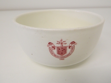 Kiewa Valley Historical Society
Bowl Ceramic, circa mid to late 1900's
This bowl was used by the State Electricity Commission of Victoria in their mess rooms for their workers during the construction of the Kiewa Hydro Electric Scheme. The imprint of the year "1921" was to identify the year that the SECV was formed which relieved the private VHEC (Victorian Hydro-Electric Company). As the scheme was of such a huge scope, isolated and time consuming nature, the feeding of its workers was quite demanding of cutlery and crockery. The use of sturdy English cups and saucers was essential. The period of construction and the isolation of the Kiewa Valley area placed heavy demand for "solid" crockery that could wear abusive handling. This period in time was one when crockery, whether for domestic or commercial use, was imported from "mother" England. This scenario was more so for governmental bodies such as rail, jails and electricity providers than domestic users. The influx of cheaper Asian crockery had not yet begun.This type of crockery item was used by the thousands of SEC Victorian staff and construction workers involved in the building of the Kiewa Hydro Electricity Scheme, over the extensive period (1938 to 1961). This was a period when Government bodies and other semi- government organisations were still tied to the "establishments" of "mother" England. It was a period in Australia's development when the Asian influence was very weak and the established ties to England and Europe was still very strong. The majority of heavy equipment and machinery was either made in England or Europe. Local/European expertise in dam construction and water management in alpine terrain came from migrants and specialist recruited from England and Europe. The quality of workmanship from big steel manufacturing plants in England and Europe could not be matched from anywhere else in the developed world.This item is a white ceramic State Electricity Commission of Victoria bowl. It is made in England and is of strong and durable ceramic. The 5mm thickness of the ceramic suggests this bowl (cereal/soup) belongs to a commercial kitchen environment and not domestic. The indent bottom of the bowl is 5mm deep with a side curvature ratio of 2:5. The ceramic is glazed to a commercial standard (worker's mess). See also KVHS 0128 (B to D) for other ceramic crockery. The seal of the State Electricity Commission of Victoria is imprinted on the top outside rim within a curved scroll and a raised fist with electrical "charges" extending out.. Snuggled within the borders of the scroll is a banner with the five stars of the Southern Cross . On the underside "Vitrified sold by Cafe & Hotel Supplies Pty Ltd Dunn Bennett & Co. Ltd. Burslem Made in England"ceramic crockery, plate, secv, state electricity commission of victoria, crockery, mt beauty chalet, bogong mess hall -
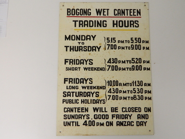 Kiewa Valley Historical Society
Sign Canteen Painted, Circa 1950
... . saucer plate secv state electricity commission of victoria ...This sign is a part of the "human" factor required for remote and difficult, large impact (both labour and other resources) projects. It is one of the "human" factors which was clearly used in the big 1930's to the 1970's "landscape redevelopment" schemes which started in the early 1900's and is highly regarded as lifting the Australian psyche of only primary producers to an industrial level, equal to any in the world.This "Wet Canteen" sign was installed at the entrance of the Bogong "workers" village "provision's hut" detailing the operational times for the SEC Victorian staff and construction workers, involved in the building of the Kiewa Hydro Electricity Scheme to obtain alcoholic beverages. This facility lasted for over the extensive period (1938 to 1961) of the "Schemes" building phase. This large project was the forerunner when industrial legislation provided for the welfare of workers living in the Bogong Village. The provision of facilities such as a "wet canteen" was of the utmost importance not only to ensure that the long running project was both successful, production wise, but also that its employees were not only physically but also mentally healthy. This sign details that all aspects required for a fit and productive labour force were in place, in this remote and demanding work environment. The majority of heavy equipment and machinery used was either made in England or Europe. A section of the specialised workforce came from local and European expertise in dam construction and water management in alpine terrain. The majority of labour came from migrants and some specialists recruited from England and Europe. At this point in time, the quality of the machines used came from England, Europe and the USA and could not be matched from anywhere else in the developed world. With a specialised workforce came the responsibility of providing all the "comforts of home" including alcoholic beverages. On site accommodation for the workforce is still a requirement for some mining areas but high market returns have produced fly in/out labour.This anodised metal sign has been "block" stenciled on. Black lettering and numbers with the main headings underlined with a red and a yellow line(emphasising the headings)In black stenciled type "BOGONG WET CANTEEN" underneath this "TRADING HOURS" Below this "MONDAY TO THURSDAY 5.15 PM TO 5.50 PM, 7.00 PM TO 9.00 PM" "FRIDAYS SHORT WEEKEND 4.30 PM TO 5.20 PM 7.00 PM TO 9.00 PM" Below this "FRIDAYS LONG WEEKEND 10.00AM TO 11.30 AM" Below this "SATURDAYS PUBLIC HOLIDAYS 4.30 PM TO 5.30 PM 7.00 PM TO 8.30 PM" bELOW THIS "CANTEEN WILL BE CLOSED ON SUNDAYS, GOOD FRIDAY AND UNTIL 4.00 PM ON ANZAC DAY"saucer, plate, secv, state electricity commission of victoria, canteen, bogong mess hall, recreational amenities, socialisation of sec vic kiewa hydro scheme labour force -
 4th/19th Prince of Wales's Light Horse Regiment Unit History Room
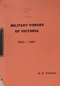
Booklet, G R Vezenry: Military Forces of Victoria 1854-1967, 1969 (estimated)
Book, A4, 24 Chapters, type print, loose leaf, side bound, Privately Published. 2 Copies1 inscribed: 4/19 PWLH 16 GEORGE ST FITZROY VIC 3065 SEP 1985military forces victoria, 1854 1967, g r vazenry, military history, army units, drill halls, military camps, military areas, southern command, rifle clubs, cadets, militia, citizen military forces, military forces victoria, 1854 1967, g r vazenry, military history, army units, drill halls, military camps, military areas, southern command, rifle clubs, cadets, militia, citizen military forces -
 Kiewa Valley Historical Society
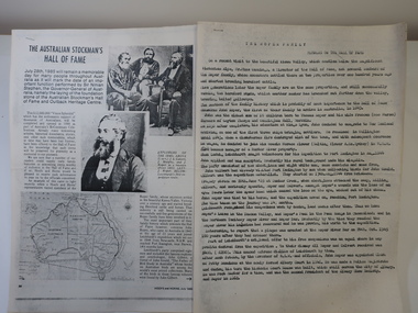
Papers - Roper Family, The Australian Stockman's Hall of Fame
The Australian Stockman's Hall of Fame is a museum located in Longreach, Queensland, Australia, which pays tribute to pioneers of the Australian outback. The centre is also dedicated to Australian stockmen who have shown bravery and courage. Registered in 1974. On July 28th 1985 the foundation stone of the Australian Stockman's Hall of Fame and Outback Heritage Centre was laid. Hoofs and Horns magazine was established by R.M.Williams in 1944 and ceased in 2005. It was aimed at cattlemen and horsemen.'The Roper family's ancestors settled in the beautiful Kiewa Valley, Victoria over a century ago and started breeding Hereford cattle and horses.' This is their interest in Hoofs and Horns but the Hall of Fame is interested in 'John Roper, who came to Australia in 1843 at the age of 23 years and joined Leichhardt's expedition ...'2 papers - Hoofs and Horns, July 1985, Page 88 and page 90 printed with photos and map. The article has the title: 'The Australian Stockman's Hall of Fame' 2 papers - Title The Roper Family compiled by Wilma Davies (nee Roper) and Mr Mike Cummings. Members of the Hall of Fame.. australian stockman's hall of flame, hoofs and horns magazine, cattlemen and horsemen, the roper family -
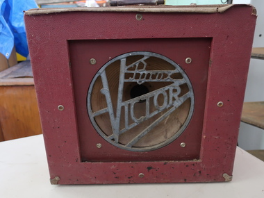 Kiewa Valley Historical Society
Film Projector Speakers x2
Speakers were used to amplify the sound of the movie being shown. The Pyrox Victor was for 16mm films and used from the 1940s.Used in the Kiewa Valley possibly at the Mt Beauty Community Hall for weekly filmsHeavy large red box with 'Pyrox Vicor' on one side. 'Rola' is inscribed at the end of the cone and centred in the front. The company, Rola, of Richmond, Victoria, Model 12U. Circa 1940s. It has a long electrical cord alo inside the case. Both speakers are the same except one is in a poor condition. pyrox victor, rola manufacturers, film projector speakers -
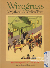 Eltham District Historical Society Inc
Book, Ross Publishing, Wiregrass: A Mythical Australian Town, drawings by Percy Leason, text by Garrie Hurchinson, 1986
Back Cover: At a time when black and white art was flourishing in Australia- with artists like Norman Lindsay, Will Dyson and Stan Cross at work - Percy Leason's creation of Wiregrass ranked him as an illustrator of surpassing genius. His early successes as a book illustrator and as a cartoonist for the Bulletin and Melbourne Punch, presaged a full flowering of his work with his creation of the mythical town and his endowment of it with a host of characters and comic situations. His inspiration came from his childhood town in Kaniva, Western Victoria but Wiregrass was every country town, with its general store, pub and church hall, its swimming hole, football ground and racecourse, its leading citizens, its battlers and mischievous children. Wiregrass flourished in Table Talk Magazine from 1926 to 1937 when Leason, seeking to escape his comic reputation and pursue "serious" art, went to live in America." Percy Leason lived in Eltham Softcover, 80 p. : ill., 1 port. ; 30 cm.ISBN 0850912490australian wit and humour, drawing, caricatures and cartoons, country life -
 Eltham District Historical Society Inc
Photocopy of newsclipping, Elections of long ago
Article in unknown newspaper of a reprint of an article: Elections of Long Ago, in Nhill Free Press, 1938. The article discusses William Hall Irvine's election In 1894 when he stood for the rural Legislative Assembly seat of Lowan. Irvine achieved a surprise victory .... Mr Irvine became a Premier of Victoria and Chief Justice and lived the later part of his life at Killeavey, Eltham.A4 black and white photocopysir william irvine -
 Eltham District Historical Society Inc
Photograph, Donaldson's Oak, Donaldsons Road, Kangaroo Ground, c.1967
Quercus Robur (English Oak) - Was planted by John Donaldson from seed collected from Windsor Great Park in 1878. Used for the Society's Banner project Joy Ness "View Hill" Kangaroo Ground June 11th 1986 In 1878 while on a trip to Scotland and England, John Donaldson visited Windsor Castle Park, where he collected some acorns which he brought back to Australia, to his property, "Kangaroo Hall" at Kangaroo Ground. He and his son John Anstruther Davidson Donaldson, who was then 10 years old, planted one near the present Donaldsons Lane, in 1878. This is now a very fine tree, 108 years old. This information comes from Miss Victoria Donaldson, daughter of John Anstruther Davidson Donaldson. Miss Donaldson suggests that "Wippell's Oak" at Kangaroo Ground may also have been grown from one of the same Windsor Park acorns.Colour Polaroid photographtrees, donaldsons oak, donaldson, donaldson road, kangaroo ground -
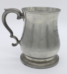 Warrnambool RSL Sub Branch
Pewter Tankard (One of Pair), 1942
The pewter tankard is part of a set of two that were presented to Lt. Col. L.G. Stevens of the 4th Light-horse Regiment. The Regiment was part of the Australian Military force in the First World War (WW1). At the end of WW1 the regiment was disbanded and it was re-raised in the 1920's as a part-time unit in the Shire of Corangamite, South Western Victoria. In World War 2 the 4th Light-horse Regiment was mechanised and became the 4th Motor Regiment. Lt.Col. Stevens served in both wars and was discharged in July 1942.. The tankards were probably presented to Lt. Col. Stevens at his retirement from the service. The set of two pewter mugs is of historic significance because of its connection to WW2 and the AIF. It indicates the relationship between Officers and Men of the regiment. It is of local significance as Lt. Col. Stevens was born and lived in Warrnambool, South Western Victoria. Pewter tankard (one of two) height 13mm circumference 3mm, ornate broken C handle height 9 mm, inscription on front, hall mark on base, mild tarnish, Inscription on front "PRESENTED TO LIEUT COL L.G. STEVENS ED. By the Officers of the 4th MOTOR REGIMENT 1.5.42 Hallmark on base "Crown & Rose" CAST PEWTER, CREST CROWN & ROSE3 surrounded by FIDE IN LONDONpewter tankards, world war 1, first world war, ww1, light horse regiment, 4th motor regiment, australian military force, aif, corangamite, 1942, world war 2, ww2 -
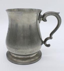 Warrnambool RSL Sub Branch
Pewter Tankard (One of Pair), 1942
The pewter tankard is part of a set of two that were presented to Lt. Col. L.G. Stevens of the 4th Light-horse Regiment. The Regiment was part of the Australian Military force in the First World War (WW1). At the end of WW1 the regiment was disbanded and it was re-raised in the 1920's as a part-time unit in the Shire of Corangamite, South Western Victoria. In World War 2 the 4th Light-horse Regiment was mechanised and became the 4th Motor Regiment. Lt.Col. Stevens served in both wars and was discharged in July 1942.. The tankards were probably presented to Lt. Col. Stevens at his retirement from the service. The set of two pewter mugs is of historic significance because of its connection to WW2 and the AIF. It indicates the relationship between Officers and Men of the regiment. It is of local significance as Lt. Col. Stevens was born and lived in Warrnambool, South Western Victoria. Pewter tankard (one of two) height 13mm circumference 3mm, ornate broken C handle height 9 mm, inscription on front, hall mark on base, mild tarnish, Inscription on front "PRESENTED TO LIEUT COL L.G. STEVENS ED. By the Officers of the 4th MOTOR REGIMENT 1.5.42 Hallmark on base "Crown & Rose" CAST PEWTER, CREST CROWN & ROSE3 surrounded by FIDE IN LONDONpewter tankards, world war 1, first world war, ww1, light horse regiment, 4th motor regiment, australian military force, aif, corangamite, 1942, world war 2, ww2