Showing 27615 items
matching yarra-river
-
 Lorne Historical Society
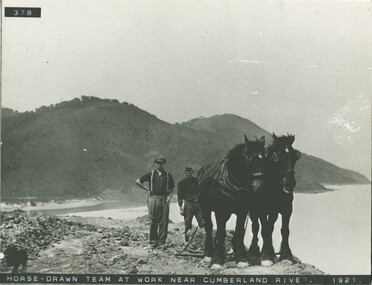
Photograph, Horse drawn team at work near Cumberland River 1921
Horsedrawn team of two Clydesdale horses and workmen at Cumberland River 1921g.o.r. clydesdale horse team cumberland river 1921 -
 Lorne Historical Society
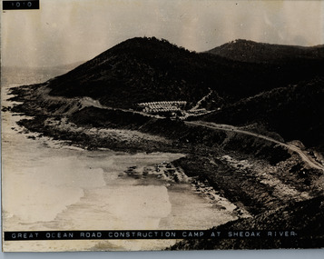
Photograph, Camp at She Oak River 1930's. G.O.R
Photograph of workers camp at She Oak River circa 1930's she oak river camp site: workers' campsite, sheoak river, workers camp -
 Lorne Historical Society
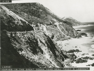
Photograph, Photograph West of Cumberland River on the Great Ocean Road
Photo showing the curves on the Great Ocean Road west of the Cumberland River/great ocean road: west of cumberland river; -
 Lorne Historical Society
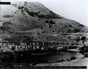
Photograph, St George River Bridge opening 1926
Photograph showing crowd at the opening of the bridge over the George River in 1926 g.o.r; george river bridge 1926; -
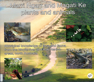 Victorian Aboriginal Corporation for Languages
Book, Ngarul Jimmy Nambatu et al, Marri Ngarr and Magati Ke plants and animals : Aboriginal knowledge of flora and fauna from the Moyle River and Neninh areas, North Australia, 2009
Aboriginal knowledge of flora and fauna from the Moyle River and Neninh areas.Maps, b&w illustrations, b&w photographs, colour photographs,marri ngarr, magati ke, wadeye, moyle river, northern territory, flora, fauna, ethnobiology -
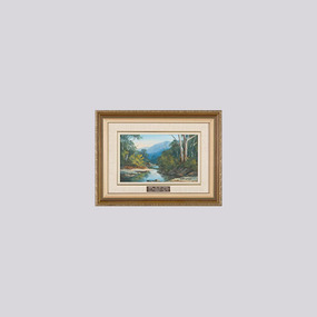 Wangaratta Art Gallery
Painting, Mary Watson, The Buckland River, 1988
Rural City of Wangaratta Collection. Gift of the Wangaratta Y's Men's Club.A river landscape painted with oils in shades of green, blue, brown, and grey.Obverse: MARY WATSON/ (bottom right corner) WINNER - PAIR SMALL PAINTINGS/ 1988 WANGARATTA ART SHOW/ Presented By WANGARATTA Y'S MEN'S CLUB/ (plaque mounted on frame)wangaratta art gallery, mary watson, painting, landscape, buckland river -
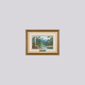 Wangaratta Art Gallery
Painting, Mary Watson, The Ovens River, 1988
Rural City of Wangaratta Collection. Gift of the Wangaratta Y's Men's Club.A river landscape painted with oils in shades of green, blue, brown, and grey.Obverse: MARY WATSON/ (bottom right corner) WINNER - PAIR SMALL PAINTINGS/ 1988 WANGARATTA ART SHOW/ Presented By WANGARATTA Y'S MEN'S CLUB/ (plaque mounted on frame)wangaratta art gallery, mary watson, landscape, painting, ovens river -
 Ballarat Heritage Services
Photograph - Photograph - Colour, L.J. Gervasoni, River at Avoca, 2011, 06/08/2011
Colour photograph of a pre-olympic swimming pool in the river at Avoca, Victoria.avoca, pre-olympic swimming pool, avoca sswimming pool -
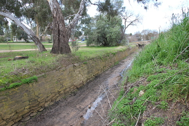 Ballarat Heritage Services
Photograph - Colour, L.J. Gervasoni, Channel near the Avoca River, Avoca, 2011, 06/08/2011
Colour photograph of a stone water channel near the Avoca River in Avoca. avoca, bridge, avoca river, channel, stone, drystone -
 Tatura Irrigation & Wartime Camps Museum
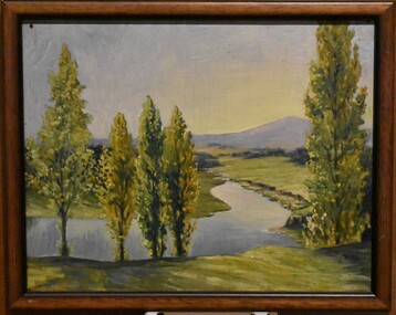
Painting - Oil Painting, 5 Trees and a River
1 of 2 Oil painting by Charlotte Rippert which were given to Otto Lobert and his wife on the wedding Camp 3 1946.landscape scene with a hill in background and five tall trees and a river in the foregroundBack: 'Oil Painting by ??Charlotte Rippert?? Wedding Gift - in Camp 3. DONOR: Otto Lobert (One of pair C3502) Nov. 1993)charlotte rippert, otto lobert, mrs lobert, camp 3 weddings, oil paintings, internment camp art work -
 Greensborough Historical Society
Map, Melbourne and Metropolitan Board of Works. Survey Division, MMBW, Yarra 2500 / 13.23. Plenty, Middle Gorge, 1978_04
Melbourne and Metropolitan Board of Works. Yarra 2500 [base map] 13-23. Plenty / Middle Gorge. Parish of Morang 3183. Municipalities of Diamond Valley 257 and Whittlesea 239. Prominent streets include: Gorge Road, Kurrak Road and Browns Lane. Features include the Plenty River and Plenty Gorge Park.MMBW Map in 1:2500 [scale] series. Cream parchment with green tape reinforcing on edges and punched holes on left edge.mmbw, melbourne and metropolitan board of works, shire of diamond valley, plenty - maps, plenty gorge park -
 Federation University Historical Collection
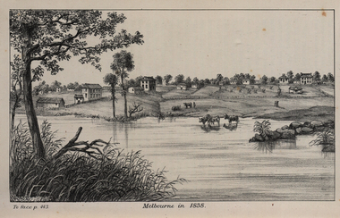
Image, John Helder Wedge, Melbourne in 1838, 1938
The following information is from http://melbourneday.com.au/about.html, accessed 30 August 2016 Melbourne was founded on 30 August 1835 by settlers who sailed from Van Diemen’s Land (Tasmania) aboard the schooner Enterprize. They landed on the north bank of the Yarra River and established the first permanent settlement, close to where the Immigration Museum at the Old Customs House — on the corner of William and Flinders Streets — stands and the place today known as Enterprize Park. Melbourne Day Committee was established to help correct the record about the founding of Melbourne and celebrate its anniversaries. The settlers came from Launceston in search of sheep-grazing land. Land had become expensive and there had long been stories told by whalers and sealers working in Bass Strait of fertile land to the north. This was the southern part of the colony of New South Wales, which the Colonial Government did not want settled at that time. After the Henty family crossed Bass Strait and settled at Portland in 1834 others quickly followed. The north bank was chosen because a small waterfall, or rapids, stopped further progress up the river. The waterfall also separated the tidal movement, providing a vital supply of fresh water. The site had previously been noted by the colony of New South Wales' surveyor, Charles Grimes, in 1803. The north bank also offered more stable, suitable ground. The people of the Kulin nation are the traditional owners of the land that became Melbourne — including the Boonwurrung, Woiwurrung, Taungurung and Djadjawurrung people, who gathered in this place for ceremonies and cultural activities. The topsail schooner Enterprize you see today is a full-size replica of the one that brought the settlers and has become a symbol of Melbourne Day. Her keel was laid at Polly Woodside Maritime Museum in 1991, and the $2.5 million, 27m vessel was launched by Felicity Kennett on 30 August, 1997, at Hobsons Bay. The original ship was bought by John Pascoe Fawkner in April 1835 specifically to search for a suitable place for a settlement in the Port Phillip District. After helping establish Melbourne, the original Enterprize continued operating as a coastal trading vessel for a number of years. She eventually disappeared off the shipping register in 1847, having been wrecked on a sand bar in the Richmond River in northern NSW, with the loss of two lives. The replica is managed by the Enterprize Ship Trust, a not-for-profit organisation. The first settlers were those on board the Enterprize — her crew and passengers. They were John Lancey , master mariner and Fawkner’s representative; Enterprize's captain, Peter Hunter; George Evans, plasterer/builder; carpenters William Jackson and Robert Hay Marr; Evan Evans, George Evans’ servant; and Fawkner’s servants ploughman Charles Wise, general servant Thomas Morgan, blacksmith James Gilbert and his pregnant wife, Mary. And Mary's cat! Enterprize set sail on her historic voyage from Launceston on July 21, 1835, stopping at George Town in northern Tasmania where creditors detained Fawkner. He was therefore not part of the first trip to Melbourne. Enterprize then left on August 1 under the command of captain Hunter. The expedition was led by Lancey, Fawkner's delegate. The party first considered Western Port and the eastern side of Port Phillip for a place to settle, before deciding on the Yarra’s north bank — known today as Enterprize Park. On Sunday, August 30, they disembarked and began to erect shelter, build a store and clear land to grow food, thus starting the permanent European settlement of Melbourne.Image of the fledgling town of Melbourne on the banks of the Yarra River. melbourne, yarra river, john helder wedge -
 Melbourne Tram Museum
Photograph - Digital Image, Kevin O'Reilly, series of three images of the Hawthorn Bridge over the Yarra, c1930, c1930's
Image from CD (Compact Diskette for use in computers) - see Reg Item 135. A series of three images of the Hawthorn Bridge over the Yarra, c1930, during the era with problems with the bridge. See separate article for more details. Richmond 6, Richmond, Richmond 3 on the CD as original files. .1 - Looking from the south west, at the Hawthorn bridge with the temporary wooden bridge being constructed on the south side. Has the cable tram depot in the photo and part of the Burnley racing course. Temporary track on the north side of the steel bridge and crossings can be seen. .2 - Looking along Bridge Road to the east with Hawthorn Bridge in the middle of the photograph. Shows the industrial and residential areas, Hawthorn Railway Station and part of the Burnley Race course, the cable tram depot building. W class tram in Church St Hawthorn and W class tram crossing the bridge on the north side temporary track. Note the cable tram used as a shelter on the north east corner of the bridge. .3 - Looking south along River St towards Bridge Road, with the Yarra River and Hawthorn Bridge on the left side of the photograph. Shows the industry in the area at the time, wool and skin Merchants, north side of the cable depot, housing and the outlook to the river!trams, tramways, hawthorn, yarra river, burnley, richmond, hawthorn bridge -
 Lakes Entrance Regional Historical Society (operating as Lakes Entrance History Centre & Museum)
Postcard, Bulmer, 1914 to 1920 c
Also a second photograph of Mrs Gasson rowing a boat on the Nicholson river old road bridge in background showing central lifting span which never worked 05348.1Black and white postcard of woman Sylvia Gasson in a row boaty on Nicholson River Hill opposite shows signs of being cleared of trees Nicholsong VictoriaNicholson Rivertransport, agriculture, genealogy -
 Orbost & District Historical Society
black and white photographs, Snowy River Mail, August 21 1987
These photographs are from the Snowy River Mail newspaper, September 9, 1987. Ron Hayward's family ran a shop in Rupert Street, Orbost.This item is associated with the history of the Orbost-Bairnsdale railway line and therefore reflects the role that the rail line played in the social and economic history of Orbost. The closure of the line was a significant event in Orbost's history.Five black / white photographs related to closure of the Orbost - Bairnsdale Railway Line.3104.1 - on back - "A view from Grandview, Newmerella, of the last train to leave Orbost on Friday August 21, 1987. As the afternoon sun lengthens the shadows on the Snowy River flats, the sun also sets on an era in Far East Gippsland transport as the last train crosses the viaduct." 3104,2 - 0n back - "Ron Hayward passes over the staff during the last crew changeover for the last train to run on the Orbost line. Ron Haywood (L) who 39 years and 6 months ago drove the first diesel loco to Orbost (T366T) presents the last staff to the driver, Bill Buckley, who took the last diesel out." 3104.3 - on back -" as above - 2nd paragraph only 3104.4 - on back - " Ron Hayward who took the first diesel engine from Bairnsdale to Orbost on February 21. 1957 when he was stationed at Orbosst. Last Friday he rode on the last diesel to Orbost after obtaining a special pass from V Line , he also handed over the staff for the last change at Orbost. The last driver was Bill Buckley." 3104.5 - on back - "LAST TRAIN ROLLS INTO ORBOST B/A Friday August 28 1987 For Ron Hayward the last train journey on the Orbost rail line was a sad occasion. Mr Hayward took the first diesel engine from Bairnsdale to Orbost on February 21, 1957, whe he was stationed at Orbost. Last Friday he rode on the last diesel too Orbost after obtaining a special pass from V-Line. He also handed over the staff for the last change at Orbost. The last driver was Bill Buckley. Mr Hayward was an engine driver with nhe railways and transferred to Orbost when steam engines used the line. He left the railways in in 1957 but took up a job with them again in 1968. He said also it was a privilege to have been able to ride on the last train, the occasion was a sad one,"east-gippsland-railway railway-closure hayward-ron buckley-bill orbost-bairnsdale-railway -
Federation University Historical Collection
Booklet, Leigh River Tunnel Gold Mining Co. Syndicate Books
Richard Squire was a student at the School of Mines Ballarat In 1905 Richard Squire was manager of the West Berry Consols at Allendale, and developed an improved system of mine ventilation, which was supported in "The Age." He was successful in combating and remedying the gas and ventilation troubles of the Deep Mines of Creswick and Allendale Districts after all had failed. MINE MANAGERS’ ASSOCIATION. Ballarat Branch. ... Mr R. B. Squire, manager of the West Berry Consols, at Allendale, submitted a paper detailing what he had done tor the betterment of ventilation in the alluvial mines of Smeaton and Mary borough districts- Members gave Mr Squire every credit for the results that he claimed to have effected; the adoption of his ideas had testified to their value to mine-owners. It was painted out, however, that for want of a thorough debate of the subject with experienced men the author had unwittingly included some general statements that required modifying in some points and extending in others, in justice to other workers among the earlier and the present day managers of mines. It was decided to invite the author to meet a sub-committee on this subject!Oblong booklets with green covers of syndicate share certificates .1 Dark Green cover 1923 all used .2 Light Green cover 1924 four pages used .3 Light Green cover 1924 all used .4 Light Green Cover 1924 all used .5 light Green Cover 1918 - 1919 four pages used .1 Front cover torn but has notes written on it. .2 Leigh River Tunnel G 21st Call written on front .3 Leigh River Tunnel G 22nd Call written on front .4 Leigh River Tunnel G 23rd Call and figures written on front .5 3 shares isued out of this book, Leigh River Share Book No. 16 A 30 written on front richard squire, leigh river tunnel gold mining co., syndicate book, hy peacock -
 Melbourne Tram Museum
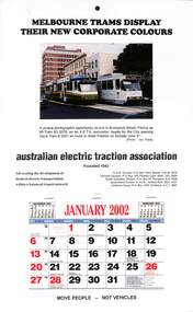
Document - Calendar, AETA 2002 featuring M>Tram and Yarra trams B2 class trams, 2002
The AETA published calendars on an annual basis through to 2005, promoting electric transport in Public Transport. The photo shows the two different liveries adopted by the Franchised operators M>Tram and Yarra trams when the system was split into two different companies. Features B2 class trams 2078 and 2021. The hand written note, dated 28-11-2005 by Keith Kings was with the calendar and records that Ken Craven was not able to arrange production for a 2006 calendar. Yields information about the AETA promotional activities.Australian Electric Traction Association (AETA) Calendar for 2002, featuring a photo by Ian Thiele of M>Tram and Yarra Trams B2 class trams passing each other in Brunswick St Fitzroy. Gives contact details for the AETA divisions. Stapled to the sheet is a 12 sheet preprinted calendar for 1985 with various details of holidays etc. Printed on card with a punched hole on the top edge. The photo is glued to the sheet. Hand written note on ruled quarto sheet.calendars, aeta, tramways, b2 class trams, tram 2021, tram 2078, brunswick st, m>tram, yarra trams, franchise, ken craven -
 Flagstaff Hill Maritime Museum and Village
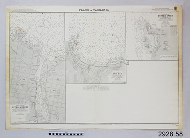
Document - Navigation Chart, Plans in Tasmania - Foster Inlet, River Mersey and Emu Bay
Navigation Chart - Plans in Tasmania - Foster Inlet, River Mersey and Emu Baywarrnambool, shipwrecked-coast, flagstaff-hill, flagstaff-hill-maritime-museum, maritime-museum, shipwreck-coast, flagstaff-hill-maritime-village, shipwrecked-artefact, river mersey, foster inlet, emu bay, navigation chart -
Lakes Entrance Regional Historical Society (operating as Lakes Entrance History Centre & Museum)
Book, Moon, Mick and Vere, My Journey from the Snowy River, 1988
Stories of day-to-day life of a family and their neighbours living along the Snowy River.settlers, animals -
University of Melbourne, Burnley Campus Archives
Album - 35mm Colour slides, Buff River
Box of slides labelled "Buff River". Various aspects of one tree. Arboriculture.buff river, tree, arboriculture -
 Orbost & District Historical Society
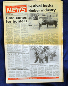
newspaper, The East Gippsland news, 28.1.1990
The East Gippsland News is generally printed in Bairnsdale. this edition was a Snowy River Mail edition. The Snowy River Mail is a weekly newspaper published in Orbost in the Shire of East Gippsland, Victoria, Australia. Previously published as The Snowy River mail and Tambo and Croajingolong gazette from 1890 to 1911. The Gippsland Courier merged with the Snowy River Mail when proprietor Lachlan Ross moved to Orbost in 1910. In 1999 the paper was acquired by the Yeates family when the Hollins family retired from the newspapers business. The paper is still being produced by the fourth generation of the Yeates family as part of East Gippsland Newspapers. This newspaper is a contemporary record of local events.A black / white newspaper, titled The East Gippsland News and dated Wednesday 28 1990. It contains articles , reports., advertisements and photographs.newspaper east-gippsland-news snowy-river-mail -
 Ringwood and District Historical Society
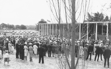
Photograph, Opening of Luther College, corner of Yarra Road and Plymouth Road, Croydon - February 1964
Written on back of photograph, "Opening new school, Yarra(?) Rd." Luther College, Feb 1964 -
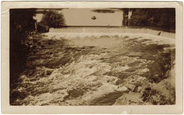 Kew Historical Society Inc
Photograph - The Race at Dight's Falls, 1925
Dight’s Falls in Studley Park is an artificial weir built on a natural rock bar across the Yarra. The weir was built in the 1840s to provide water to the ‘Ceres’ flour-mill, one of the first in Victoria. The falls were later to become known as Dight’s Falls after the owners of the mill. Later, a pumping station was built on the Kew side of the river, which pumped water uphill to a reservoir in Walmer Street that provided water to the Melbourne Botanical Gardens and to Albert Park Lake. The area around Dight’s Falls was and is frequently used for recreational activities.Original, black and white positive of water flowing over the 'Race' at Dight's Falls in MelbourneInscribed verso: "The Race at Dight's Falls / River Yarra Melbourne / 1.3.25" "Kodak Print"dight's falls, river yarra, yarra -- kew (vic.) -
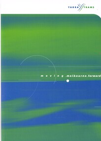 Melbourne Tram Museum
Document - Folder, Yarra Trams, "Moving Melbourne Forward", c2000
Printed folded heavy card folder with the title "Moving Melbourne Forward", able to contain papers, but more providing information about Yarra Trams following the formation of Yarra Trams - Transdev and Transfield in 1999. Notes Yarra trams "owns" 201 trams and 130km of track. Has a message from the CEO Hubert Guyot and details of the network and Yarra's visions for the future. Two copies held.trams, tramways, yarra trams, tramways, melbourne, transfield, transdev -
 Eltham District Historical Society Inc
Photograph, Henley Bridge, Spring Excursion, Exploring the Upper Yarra, 22 October 1995, 22/10/1995
[article by Bettina Woodburn in EDHS Newsletter No. 105, November 1995:] EXPLORING THE UPPER YARRA - We enjoyed the Spring Excursion, this year "Exploring the Upper Yarra" - in spite of the constant rain and the countryside under the cloud cover, especially in the valleys, being mainly shiny shades of green. The occasional fields of buttercups, clumps of arum lilies and splendid rhododendron and other flowering bushes became very special. The Cobb and Co coach was warm and a cosy retreat as we zig-zagged on the highways and byways to glimpse the Yarra River, upstream and down, its secret places, and particularly the many bridges. Russell excelled as 'Poet Laureate', reading from Dacre Smyth's book. This 1979 publication includes paintings of all the bridges along the river with poems and brief descriptions of each one. Some of the bridges are in out-of-the-way places and are not very well known. We looked forward to hearing the poetry as much as seeing the 'constructions'… Big Pat (was he short or tall, lean or fat? - he did win the £200 reward for discovering gold and had the creek named after him), about the 'Eddies'?, and the disliked 'meccano' bridge in Warburton, etc. etc. The hot roast lunch in the old Reefton Hotel was also most welcome. It was easy to imagine it peopled by miners and early settlers. Starting by crossing the new (1974) concrete bridge at Warrandyte we headed through Wonga Park with views to the Christmas Hills and to the escarpment of the Yering Gorge, which causes flood waters to back up through the Yarra Glen plain, so avoiding disasters downstream. At the end of a long driveway we found the wooden, privately owned Henley Bridge (1935 after the 1934 floods). This facilitates access to different parts of Henley Farm and to Lilydale. Everard Park, named after Blanche Shallard's father, a State Member for 17 years, below the Highway Yarra crossing was in need of care. It is 10 miles from Yarra Glen by road but, as "Yarra Marra” canoeists well know, 32 winding miles down by water. After more delightful countryside scenes we joined the Warburton Highway at Woori Yallock. From the old Railway Station at Launching Place the Centennial Trail for walkers, cyclists and horse riders has replaced the rails. The line from Lilydale was opened in 1901, and the last diesel freight train ran to Warburton in 1965. It continued to rain as we had morning tea in Warburton in a shelter between footbridges. From here we continued upstream past the Bridge to O'Shannassy Lodge and Reservoir, Starvation Creek, and the Peninsular tunnel (miners dug it as at Pound Bend) which we visited (scrambling down those steps!) on our return after lunch. Our furthermost point was the Upper Yarra Dam Reserve (and vast catchment area). Finished in 1957 after ten years' work and 100 years after Yan Yean, it supplies much of Melbourne's water. After crossing the 30m Launching Place Bridge to the Eltham side of the Yarra and Healesville, we saw in the distance the Yarra Glen Timber Trestle Bridge over the river flats "the longest for years in the land it was said!" Harry's dream of "better weather over the Divide" unfortunately didn't come true, but I'm sure we 36 members will retain happy memories of a day that was wet and green and filled with Bridges. Situated on the Yarra River, 5.5 kms south of Christmas Hills on private property. This timber trestle bridge is said to have been built some time after 1907 by Melbourne master-builder, David Mitchell (the father of Dame Nellie Melba), to connect his two "Henley Farm" properties with Lilydale. In earlier days, when the McPhersons owned the property, their children used a punt to cross the river to attend Yering Primary School. This private bridge is best viewed from the end of Wendy Way. - Source: Christmas Hills Past and Present, Yarra Glen & District Historical Society, 2004.Two colour photographsactivities, henley bridge, upper yarra -
 Kew Historical Society Inc
Photograph - Kane's Bridge on the Yarra River, December 1934
In 1928 a footbridge was erected to link Kew with the public golf course across the Yarra. The total cost of construction came to 250 pounds and the bridge became known as Kane's Bridge. During the 1934 floods the bridge was washed downstream, and was subsequently rebuilt. The present form of the bridge resembles the earlier bridge which crossed from the Yarra Bend Asylum to Kew, further upstream. (VHD)Original, black and white positive of Kane's Bridge in December 1934, when the 'great flood' of the Yarra caused the bridge's destruction. Inscribed verso: "Kane's Bridge Yarra in flood Dec 1934"river yarra, yarra -- kew (vic.), kanes bridge, 1934 floods -
 Kew Historical Society Inc
Photograph, Chipperfield's Boat House & Floating Pontoon, 1934
Living with natural processes was frequently a challenge to early European settlers and later residents of what was in the 1850s administered by the Borondara Road Board. This was compounded by the area being bounded on three sides by rivers (Yarra River, Koonung Creek and Gardiner's Creek). In 1849, the historian James Bonwick recorded that "our district [Kew] suffered considerably. Mr Wade speaks of 80 acres, out of 100 acres of his cultivated paddock, covered by water." Newspapers continued to describe major flooding in Kew in 1863, 1869, 1878, 1880, 1889, 1891, 1916 and 1934. While the construction of the Upper Yarra dam in 1957 reduced the levels of flowing downstream, local and riverine floods continue. A number of boat houses operated on both sides of the River Yarra at Kew. Chipperfield's Boat House was located on the Yarra near the corner of Kilby and Willsmere Roads.The Kew Historical Society's pictures and map collections testify to the impact of flooding in the district. They have historical importance in documenting the extent of flooding in the district and its affects on homes, services and recreation. Numerous photographs record flooding throughout the Twentieth Century.Floating pontoon at Chipperfield's Boat House where the canoes were stored, taken in 1934, presumably before the 1934 Flood. This area of the Yarra was shallow with a number of mid river sandbanks and a popular swimming area for locals.yarra river, chipperfield's boathouse, pontoon -
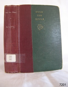 Flagstaff Hill Maritime Museum and Village
Book, Over The River
Pattison Collection This item is from the ‘Pattison Collection’, a collection of books and records that was originally owned by the Warrnambool Mechanics’ Institute, which was founded in Warrnambool in 1853. By 1886 the Warrnambool Mechanics’ Institute (WMI) had grown to have a Library, Museum and Fine Arts Gallery, with a collection of “… choice productions of art, and valuable specimens in almost every branch and many wonderful national curiosities are now to be seen there, including historic relics of the town and district.” It later included a School of Design. Although it was very well patronised, the lack of financial support led the WMI in 1911 to ask the City Council to take it over. In 1935 Ralph Pattison was appointed as City Librarian to establish and organise the Warrnambool Library as it was then called. When the WMI building was pulled down in 1963 a new civic building was erected on the site and the new Warrnambool Library, on behalf of the City Council, took over all the holdings of the WMI. At this time some of the items were separated and identified as the ‘Pattison Collection’, named after Ralph Pattison. Eventually the components of the WMI were distributed from the Warrnambool Library to various places, including the Art Gallery, Historical Society and Flagstaff Hill. Later some were even distributed to other regional branches of Corangamite Regional Library and passed to and fro. It is difficult now to trace just where all of the items have ended up. The books at Flagstaff Hill Maritime Village generally display stamps and markings from Pattison as well as a variety of other institutions including the Mechanics’ Institute itself. RALPH ERIC PATTISON Ralph Eric Pattison was born in Rockhampton, Queensland, in 1891. He married Maude Swan from Warrnambool in 1920 and they set up home in Warrnambool. In 1935 Pattison accepted a position as City Librarian for the Warrnambool City Council. His huge challenge was to make a functional library within two rooms of the Mechanics’ Institute. He tirelessly cleaned, cleared and sorted a disarrayed collection of old books, jars of preserved specimens and other items reserved for exhibition in the city’s museum. He developed and updated the library with a wide variety of books for all tastes, including reference books for students; a difficult task to fulfil during the years following the Depression. He converted all of the lower area of the building into a library, reference room and reading room for members and the public. The books were sorted and stored using a cataloguing and card index system that he had developed himself. He also prepared the upper floor of the building and established the Art Gallery and later the Museum, a place to exhibit the many old relics that had been stored for years for this purpose. One of the treasures he found was a beautiful ancient clock, which he repaired, restored and enjoyed using in his office during the years of his service there. Ralph Pattison was described as “a meticulous gentleman whose punctuality, floorless courtesy and distinctive neat dress were hallmarks of his character, and ‘his’ clock controlled his daily routine, and his opening and closing of the library’s large heavy doors to the minute.” Pattison took leave during 1942 to 1942 to serve in the Royal Australian Navy, Volunteer Reserve as Lieutenant. A few years later he converted one of the Museum’s rooms into a Children’s Library, stocking it with suitable books for the younger generation. This was an instant success. In the 1950’s he had the honour of being appointed to the Victorian Library Board and received more inspiration from the monthly conferences in Melbourne. He was sadly retired in 1959 after over 23 years of service, due to the fact that he had gone over the working age of council officers. However he continued to take a very keen interest in the continual development of the Library until his death in 1969. WARRNAMBOOL MECHANICS’ INSTITUTE Warrnambool's Mechanics' Institute (or Institution as it was sometimes called) was one of the earliest in Victoria. On 17th October 1853, a meeting was held where it was resolved to request the Lieutenant Governor of the Colony to grant land for the erection of a Mechanics' Institutes building. A committee was formed at the meeting and Richard Osburne chaired the first meeting of this committee. The land on the North West corner of Banyan and Merri Streets was granted but there were no funds to erect the building. The Formal Rights of the Warrnambool Mechanics' Institute's encompassed its aims and these were officially adopted in1859; "This Institution has for its object the diffusion of literary, scientific, and other useful knowledge amongst its members, excluding all controversial subjects, religious or political. These objects are sought to be obtained by means of a circulating library, a reading room, the establishment of classes, debates, and the occasional delivery of lectures on natural and experimental philosophy, mechanics, astronomy, chemistry, natural history, literature, and the useful and ornamental arts, particularly those which have a more immediate reference to the colony." The Warrnambool Mechanics' Institute opened its first reading room in November 1884 in the National School building at the corner of Banyan and Timor Streets. The Institute was funded by member subscription, payable on a quarterly, half-yearly or yearly basis. Samuel Hannaford, the Manager of the Warrnambool Bank of Australasia, was the first Honorary Secretary of the Mechanics' Institutes, and an early President and Vice-President. He also gave several of the early lectures in the Reading Room. Another early Secretary, Librarian and lecturer was Marmaduke Fisher, the teacher at the National School. Lecture topics included The Poets and Poetry of Ireland', 'The Birth and Development of the Earth', 'The Vertebrae - with Remarks on the pleasures resulting from the study of Natural History' and 'Architecture'. In 1856 the Reading Room was moved to James Hider's shop in Timor Street, and by 1864 it was located in the bookshop of Davies and Read. In the 1860's the Mechanics' Institute struggled as membership waned but in 1866, after a series of fundraising efforts, the committee was able to purchase land in Liebig Street, on a site then called Market Square, between the weighbridge and the fire station. A Mechanics' Institute building was opened at this site in August 1871. The following year four more rooms were added to the main Reading Room and in 1873 the Artisan School of Design was incorporated into the Institute. The same year Joseph Archibald established a Museum; however, it deteriorated when he was transferred to Bendigo in 1877. In 1880, with Archibald's return to Warrnambool, the Museum was re-established, and in 1885 a new building was built at the back of the Institute to accommodate the re-created School of Design, the Art Gallery and the Museum. In 1887 the Museum section was moved to the former courthouse in Timor Street (for some time the walls of the building formed part of the TAFE cafeteria but all is now demolished)). In 1911 the Museum was transferred back to the original building and the management of the Mechanics' Institute was handed over to the Warrnambool City Council. The Museum and Art Gallery became one and housed many fine works of art, and the Library continued to grow. The building was well patronised, with records showing that at the beginning of the 20th century there were between 500 and 800 visitors. During World War One the monthly figures were in the thousands, with 3,400 people visiting in January 1915. The Museum was a much - loved Institution in Warrnambool until the contents of the Museum and Art Gallery were removed to make room for the Warrnambool City Council Engineers' Department. The contents were stored but many of the items were scattered or lost. When the original building was demolished the site became occupied by the Civic Centre, which included the new City Library. (The library was temporarily located in the old Palais building in Koroit Street.) In the process of reorganisation the Collection was distributed amongst the community groups: -The new City Library took some of the historical books and some important documents, historic photographs and newspapers. -The Art Gallery kept the 19th Century art collection and some of the artefacts from the museum. -The Historical Society has some items -The State Museum has some items -Some items were destroyed -Flagstaff Hill Maritime Village has old newspapers, Government Gazettes, most of the Mechanics' Institute Library, ledgers and documents connected to the Mechanics' Institute Library, some framed and unframed artworks and some photographs. The Warrnambool Mechanics' Institute Library book collection is deemed to be of great importance because it is one of the few collections in an almost intact state, and many of the books are now very rare and of great value. The Pattison Collection, along with other items at Flagstaff Hill Maritime Village, was originally part of the Warrnambool Mechanics' Institute’s collection. The Warrnambool Mechanics’ Institute Collection is primarily significant in its totality, rather than for the individual objects it contains. Its contents are highly representative of the development of Mechanics' Institute libraries across Australia, particularly Victoria. A diversity of publications and themes has been amassed, and these provide clues to our understanding of the nature of and changes in the reading habits of Victorians from the 1850s to the middle of the 20th century. The collection also highlights the Warrnambool community’s commitment to the Mechanics’ Institute, reading, literacy and learning in the regions, and proves that access to knowledge was not impeded by distance. These items help to provide a more complete picture of our community’s ideals and aspirations. The Warrnambool Mechanics Institute book collection has historical and social significance for its strong association with the Mechanics Institute movement and the important role it played in the intellectual, cultural and social development of people throughout the latter part of the nineteenth century and the early twentieth century. The collection of books is a rare example of an early lending library and its significance is enhanced by the survival of an original collection of many volumes. The Warrnambool Mechanics' Institute’s publication collection is of both local and state significance. Over The River Author: John Galsworthy Publisher: William Heinemann Limited Date: 1933 The label on the spine with typed text PAT FIC GAL Pastedown front endpaper has a sticker from Warrnambool Mechanics Institute and Free Library covered by a sticker from Corangamite Regional Library Service Front loose endpaper has a stamp from Corangamite Regional Library Service shipwrecked-coast, flagstaff-hill, flagstaff-hill-maritime-museum, warrnambool, maritime-museum, shipwreck-coast, flagstaff-hill-maritime-village, shipwrecked-artefact, book, pattison collection, warrnambool library, warrnambool mechanics’ institute, ralph eric pattison, corangamite regional library service, warrnambool city librarian, mechanics’ institute library, victorian library board, warrnambool books and records, warrnambool children’s library, great ocean road, over the river, john galsworthy -
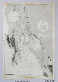 Flagstaff Hill Maritime Museum and Village
Document - Navigation Chart, Tavoy River
British Admiralty Navigation Chart - Bay of Bexgal - East Coast - Bruma - Tavoy Riverwarrnambool, shipwrecked-coast, flagstaff-hill, flagstaff-hill-maritime-museum, maritime-museum, shipwreck-coast, flagstaff-hill-maritime-village, shipwrecked-artefact, navigation chart, british admiralty navigation chart, british admiralty, tavoy river, bay of bexgal, bruma -
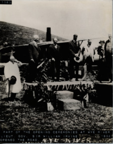 Lorne Historical Society
Photograph, Wye River Opening Ceremony 1932
Opening Ceremony at Wye River G.O.R 1932. Lt. Governor Sir William Irvinewye-river-opening-ceremony-1932. lt-govenor-sir-william-irvine