Showing 8856 items
matching lake.
-
 Lakes Entrance Historical Society
Photograph - Football team, Bairnsdale Advitisor, 1/09/2003 12:00:00 AM
Other number 03640.3Colour photograph of Football Club Thirds Premiership team 2003, Back Row: Rhys Allitt, Michael Ballista, David Kelly, Xavier Ryan, Edward McKenzie, Chris Robertson, Xavier Ellis, Daniel Carsons, Ray Reggardo (trainer). Centre Row: Chris McKenzie,(trainer), Wayne Reggardo (president), Damien Cooper,(assistant coach), Luke Baldwin, Tom Bulmer, Michael O'Connell, Dean Cook, Owen Hensworth-Smith, Brad Hallyer, Daniel Machelin, Nathan Allen, Chris Bulmer, Geoff Ellis(trainer) Front Row: Joel Walker, Chance James, Brett Campise, Nathan Peglar (captain) Lou Battista)coach) Rene Cerda, Chris LeMaitre, Chris Mathers, Tom Cook (property steward), Nicholas Bulmer(mascot) Lakes Entrance Victoriaclubs, football -
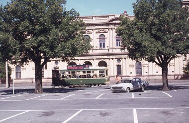
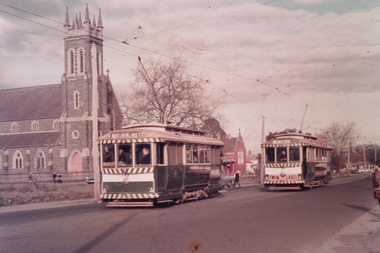 Ballarat Tramway Museum
Photograph - Digital image Set of 10, Tony Smith, 1971
Yields information about Ballarat Tramways and trams prior to the closure of the tramway system.Set of 10 digital images of Ballarat trams prior to closure, scanned from original slides by Tony Smith, 1971 prior to closure of the system. The following photos have suffered colour change and showing some deterioration - fungal growth. .1 - 13 (Sturt St West) and 27 (Victoria St with Twin Lakes sign) crossing at King St loop with St Alipius church in the background. .2 - 13 (Sturt St West) and 17? (Mt Pleasant) crossing at Parker St loop, with the Ballarat College in the background. .3 - Single trucker, inbound, approaching the Parker St Loop, showing Mt Pleasant. .4 - 30 in Sturt St, descending the hill to Grenville St, with other trams in the background, including Woolworths Big W and the Dickins Store. Also has the 8 hour monument. 30 showing City. .5 - 37 running Special, no passengers, crossing Lydiard St Nth, heading for Grenville St. Has the Titanic bandstand, Mechanics Institute in the background. .6 - 33 and three other single truckers in the City Loop - has the Ballarat Gas Co and other buildings in the background. .7 - 37 showing Special passing 33 and other trams parked in the City Loop. Has Dickins, Ballarat Gas Co, Edmonds, Patersons store in the background. .8 - 17 crossing Lydiard St Nth in Sturt St. 17 has destination of Gardens via Drummond Nth, and a Twin Lakes sign. Includes the T&G sign in the background. .9 - 31, a single trucker and bogie tram crossing at Depot loop, Wendouree Parade - 31 showing Victoria St. .10 - 17 waiting in Gardens Loop, showing Mt Pleasant.trams, tramways, king st, victoria st, sturt st west, sturt st, grenville st, city loop, gardens loop, wendouree parade, tram 13, tram 27, tram 30, tram 37, tram 33, tram 17, tram 31 -
 Ballarat Tramway Museum
Slide - 35mm slide/s - set of 20, Eldon Hogan, 22/05/1971 12:00:00 AM
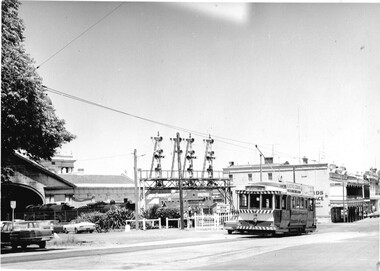
Set of 20 35mm Agfa colour blue and white plastic mount slide - featuring photos taken during an Association of Railway Enthusiasts Tour by Eldon Hogan. Folder had the date "22/5/1971" on it. Scanned on the Canon scanner at the depot 15/12/2005 at the time of the installation of the scanner. .1 - No. 25 in Nolan St with Lake Weeroona in the background. .2 - Three Birneys at the Depot junction, 30 and 29 with Conoles Hotel, McCrae St in the background. .3 - No. 5 in front of the Shamrock Hotel, Pall Mall .4 - No. 29 in front of the Shamrock Hotel with Stonemasons sign in the background. .5 - No. 18 ditto .6 - No. 30 and another Birney at the Quarry Hill terminus .7 - No. 24 southbound High St at the Violet St intersection with a "Mine Open" sign in the foreground and the Cathedral in the background. .8 - No. 19 at the Golden Square terminus, with the Golden Square Hotel in the background. .9 - No. 29 - side on view, North Bendigo line? Thunder St? .10 - No. 30 crossing the railway overbridge, inbound from Eaglehawk with a number of photographers in the foreground. .11 - No. 29? ditto .12 - No. 5 outbound - side on view, Thunder St, North Bendigo line? .13 - No. 29 and 30 at the intersection of High St and Brazier St with Church or School hall in the background. .14 - ditto .15 - ditto .16 - No. 25 and the two Birneys at the Eaglehawk terminus. .17 - No. 29 and two other trams at ditto .18 - No. 30 and 19 adjacent to the Lake View Hotel, McCrae St .19 - No. 5 and 25 crossing on the Eaglehawk Line, Ironbark? .20 - No. 29 at Quarry Hilltramways, trams, bendigo, lake weeroona, pall mall, golden square, eaglehawk, quarry hill, tram 25, tram 30, tram 29, tram 5, tram 18, tram 19, tram 24, tram 25 -
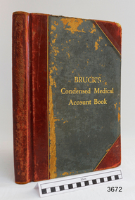 Flagstaff Hill Maritime Museum and Village
Financial record - Medical Accounts, c. 1929
The accounts records in the Medical Accounts book start in February 1929 and refer to many of Warrnambool’s local names and addresses. The ledger book belonged to Dr John Hunter Henderson who conducted his medical practice from his home and surgery at Birchwood, 214 Koroit Street, Warrnambool, from 1904-1939. This particular accounts book spans from February 1929 to May 1931. Dr Henderson retired in 1939 and moved to Melbourne. His home, medical practice and many of his surgery’s items, including the Medical Accounts Book, were transferred to Dr William Roy Angus in that same year. The patients’ addresses on page 1 of the ledger include John Lee of St Marys Road, Wangoom. John Lee’s name has two entries on this page. He Grandfather, also John Lee, was a notable pioneer of the district. JOHN LEE John Lee was born in 1884 and died in 1948. His father (1845-1892) and grandfather (1814-1887) were also named John Lee. John Lee’s Grandfather, Grandmother, Father and Uncle arrived in Australia from Ireland in 1852. The colonial family settled in St Marys Road, Wangoom, Victoria and have a long association with the district. John Lee, born in 1814, is proudly listed amongst the names on the commemorative Warrnambool Pioneers Board, having arrived in Australia In 1852. In 1855 John’s Grandfather John Lee, aged 41, was head teacher of the Tower Hill School on the south bank of Tower Hill. Two years later, in 1857, the north bank of Tower Hill was surveyed and named the township of Koroit. In November of that year John Lee continued on as head master, now at the newly built Tower Hill Lake National School Number 618, on land that is now Victoria Park Recreation Reserve, on High Street, Koroit. John died in Warrnambool in 1887 but even 50 years later an ex-student wrote a letter to The Age newspaper, recalling memories of John Lee, his head master of the 1860s at the Tower Hill Lake Common School in Koroit. DR WILLIAM ROY ANGUS Doctor Angus had previously practiced in Nhill. The accounts book and many more items of Dr Angus were donated to Flagstaff Hill Maritime Village by the family of Dr Angus, Surgeon and Oculist. The Medical Accounts Book is part of the “W.R. Angus Collection” that includes historical medical equipment, surgical instruments and material once belonging to Dr Edward Ryan and Dr Thomas Francis Ryan, (both of Nhill, Victoria) as well as Dr Angus’ own belongings. The Collection’s history spans the medical practices of the two Doctors Ryan, from 1885-1926 plus that of Dr John Henderson from 1904+1939 and Dr Angus until he retired, from 1923 - 1969. The Medical Accounts Book is significant as a record of the names, addresses and health of the people in Warrnambool and District in the early 20th century. The Book is significant for its early 20th century association with two local doctors, Dr John Henderson and Doctor William Roy Angus, whose practices span from 1904-1969. The Book is also significant historically for its association with the ancestors of patient John Lee, whose Grandfather is recognised on the Warrnambool pioneer Board as one of the early pioneers in Victoria, arriving in 1852. Ledger, Medical Accounts Book. Title is Bruck’s Condensed Medical Account Book. Book has hardback, green cover, bound and reinforced with red leather and printed title in gold lettering. The pages of index tabs in the beginning of the book have no entries. The first page of the accounts section of the book have the hand written heading “February 1929”. The book continues until the end of May 1931. Inside both front and back cover are hand written notes in different scrips. Both black and blue ink has been used. The book belonged to Dr John Hunter Henderson. It is part of the W.R. Angus Collection."Bruck’s Condensed Medical Account Book"flagstaff hill, warrnambool, shipwrecked coast, flagstaff hill maritime museum, maritime museum, shipwreck coast, flagstaff hill maritime village, great ocean road, medical treatment, medical history, medical accounts, medical administration, medical record 1929, ledger, bruck’s condensed medical account book, john hunter henderson, william roy angus, edward ryan, thomas francis ryan, john lee, tower hill school, tower hill lake national school, koroit primary school, victoria school 628, st marys wangoom, warrnambool pioneer, birchwood, 214 koroit street warrnambool -
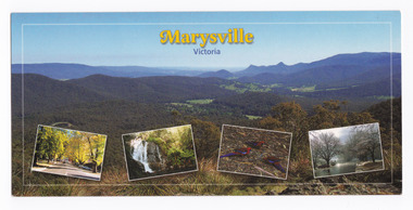 Marysville & District Historical Society
Postcard (item) - Colour postcard, Imagine That! Promotions, Marysville-Victoria, 2002
A colour photograph of the view from Keppel Lookout of Marysville and the Cathedral Range along with photographs of the main street in Marysville, Steavenson Falls, birdlife and snow in Marysville. A colour photograph of the view from Keppel Lookout of Marysville and the Cathedral Range along with photographs of the main street in Marysville, Steavenson Falls, birdlife and snow in Marysville. This postcard was produced by Imagine That! Promotions as a souvenir of Marysville.Marysville is a beautiful small country town approximately 100 km's from Melbourne. It is/ well known for its amazing autumn colours, prolific wildlife and is only half an hours drive/ from Lake Mountain, Australia's largest Cross Country Skiing Resort./ Featured is (Main Picture) Marysville with the picturesque Cathedral Range in the back-/ ground as seen from Keppel Lookout. From the left is Marysville's main street during/ Autumn, Steavenson Falls, Crimson Rosellas and Marysville covered by a low snowfall. Imagine That!/ Post Cards Imagine That! Promotions/ Country Victoria Collection/ Landscape 1/ c 2002/ Ph: (03) 5966 8523 Fax: (03) 5966 8458 Mob: 0418 593 534 Place/ Stamp/ Heremarysville, keppel lookout, cathedral range, murchison street, steavenson falls, scarlet rosella, snow, imagine that! promotions, postcard, souvenir -
 The Beechworth Burke Museum
Audio - Oral History, Jennifer Williams, Dr Roy Phillips, 8th October 2000 (exact date unclear)
Roy Phillips was born in 1907 in Yackandandah and moved with his family to Beechworth when he was five years old. His father was involved in dredging operations at Lake Sambell but his parents also had other family living in Beechworth, with whom they lived. Dr Phillips tells vivid stories about life in Beechworth in the first half of the Twentieth Century, from the daily lives of young children of the time to the town's relationship to the local Chinese community. He discusses features of the landscape such as 'The Rock' at which community concerts were held and 'The Echo' (an echo-sounding point over a nearby gully) which he states are no longer used in the same way. He also discusses changing community attitudes to various issues, for example, 'not being coddled' as a child but living in a town with very strict rules about people of different religions mingling. This oral history recording was part of a project conducted by Jennifer Williams in the year 2000 to capture the everyday life and struggles in Beechworth during the twentieth century. This project involved recording seventy oral histories on cassette tapes of local Beechworth residents which were then published in a book titled: Listen to what they say: voices of twentieth century Beechworth. These cassette tapes were digitised in July 2021 with funds made available by the Friends of the Burke.Dr Roy Phillips' account of his life in Beechworth in the early part of the 20th Century is historically and socially significant to the cultural heritage of the region. He describes town life from a child's point of view during a time of transition to life after the Gold Rush era, including social tensions existing between cultural groups such as the Chinese community and European-heritage townspeople and between people of different religious groups in Beechworth. This oral history account is socially and historically significant as it is a part of a broader collection of interviews conducted by Jennifer Williams which were published in the book 'Listen to what they say: voices of twentieth-century Beechworth.' While the township of Beechworth is known for its history as a gold rush town, these accounts provide a unique insight into the day-to-day life of the town's residents during the 20th century, many of which will have now been lost if they had not been preserved.This is a digital copy of a recording that was originally captured on a cassette tape. The cassette tape is black with a horizontal white strip and is currently stored in a clear flat plastic rectangular container. It holds up 40 minutes of recordings on each side.Dr Roy Phillips /beechworth, yackandandah, wangaratta, mining, dredging, 1910s, 1920s, 1930s, chinese community, typhoid, lake kerferd, reminiscences, memories, childhood, lake sambell, alcoholism, new year celebrations, transport, horses, foresters lodge, oddfellows lodge, funeral practices, child-rearing practices, star hotel, the rock, racism, chinese dragon, benevolent society, star lane coach building factory, outdoor concerts, gold, jimmy ingram, kelly gang, kelly family, churches, catholic, methodist, protestant, anglican, confuscionist, buddhism, women's christian temperance association, hotels, twentieth century, coronation of king george iv, echo point, the echo, tippany cat, marbles, children's games, cornish, cornwall, listen to what they say, oral history -
 Orbost & District Historical Society
black and white photograph, Vogt, Stanley, 1918
Maize,has been grown on the Orbost flats for at least 70 years. When early settlers began to arrive on the Snowy River somewhere in the 1880s, the land was mostly swamps and heavily timbered jungle on the river frontages. The swamps were drained, bit by bit, by men with short handled shovels and working in mud and water. The frontages were cleared by axe and shovel and fire. Several kinds of crops were experimented with such as hops, hemp and maize, the latter grew particularly well and became the main crop of district. The problem then was to thresh and deliver the product to the market. A small single cob machine was brought here and one man turned the handle, while the boy or Mum fed the cobs singly into the machine. A good day’s work would thresh about 50 bushels or about 12 bags (4 bushels). The task then was to cart the maize to market. For a few years this was done by horses and dray carrying about 60 bushels to Mossiface, where it was loaded onto river boats to Lakes Entrance, and then by ocean boats to Melbourne. Later it was taken to Bairnsdale by foot and loaded onto the trains to Melbourne. (more information in Newsletter October 2006) This crib, measuring seven chains, sixteen feet, contained 10,000 bags of maize cobs which were grown by Linc Timmons on Peter Irvine's farm (Fairlea?) in Orbost, East Gippsland. The growing of maize in the Orbost district contributed significantly to the economy of the township for many years, The many maize cribs once seen on the surrounding farms have now disappeared and this photograph is a pictorial record of that significance.A black / white photograph of a large maize crib full of maize in a paddock. There is a large framed copy of the original.agriculture-orbost farming-maize-orbost maize-crib-orbost -
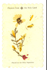 Federation University Historical Collection
Plant specimen, Flowers from the Holy Land, possibly c1949
This item was located in a book called The English Lakes which was owned by E.C. Holmes [Edward Carter Holmes was the name of my mother's, Elizabeth Mary [Elizabeth] Holmes family's pioneer settler. He arrived in Geelong on the 28th of June, 1849, with his wife Sarah and their first child Frances Harriet as assisted immigrants (people whose passage was subsidised by an assisted immigration scheme) to New South Wales at Port Henry, Geelong in the sailing boat ‘Larpent’. Sarah and Edward arrived two years before his mother, Harriet, arrived as unassisted passenger in Geelong on ‘The Eagle’. 200 of the " Larpent" passengers had been selected in England by Rev John Dunmore Lang whose wish was to encourage the migration of hard-working, God-fearing Protestants to the colony. He sponsored two ships, the "Travancore" and the" Larpent', to bring the settlers to Australia in 1849 with Dr Alexander Thomson, a Sydney Presbyterian minister, ready to receive and settle them. Thomson owned section 10 of the parish of Barrabool known as the Kardinia section — a square mile of undulating land west of Colac, still known today as Larpent. Among the 'Larpent' immigrants were many well-known Ballarat and District pioneers including Armitage, Mercer, Oddie and Scott. For more details about this migration scheme refer to: A thoroughly Protestant emigration: the emigration activities of the Rev. Dr. J.D. Lang / Ian Wynd.2006.] [source: Jane Dyer 2024] Printed card with a pressed botanical specimen glued onto it. Printed onto the card 'Flowers from the Holy Land. Placed on the Holy Sepulchrechatham family archive, chatham, holmes, ec holmes. holy land, relic, botanical, botany, holy sepulchre, botanical specimen -
 Ballarat Heritage Services
Photograph - Colour, Bessibelle Drystone Sheep Wash, 2016, 24/04/2016
The Bessiebelle Sheepwashes and Yards complex is located on the former 14,000 acre Ardonachie Run, established in 1848 by pastoralist Samuel Gorrie, then carrying 6,000 sheep. In 1864 this run was subdivided into smaller runs, and the sheep washes were located within Mount Eccles and Lake Gorrie Run. The date of construction of the washes and walls is not known, although they were probably constructed within the period 1848-1864. The Bessiebelle Sheepwashes and Yards are probably the largest and most sophisticated surviving example of a traditional pastoral property sheepwash in Victoria. They clearly demonstrate the large network of races, yards and folds necessary for washing thousands of sheep over a short period of time. The Bessiebelle sheep washes apparently predate later technological changes and the necessity for hot water washing. The Bessiebelle sheepwashes and yards are of landscape significance as a cultural landscape which has been both modified by, and cleverly adapted to, an annual process that was of critical importance within the pastoral calendar. The drystone walls and races appear to evolve from the rocky terrain, and have a strong organic affinity with the prevailing harsh landscape. The drystone walls demonstrate a high level of craftsmanship and skill in their construction, and reflect the extensive scale of pastoral operations across the landscape. The Bessiebelle sheepwashes and yards are of archaeological significance to the State of Victoria. The site has not been fully surveyed but its complexity strongly suggests a potential to reveal more about the washing processes and associated pastoral occupation and activity in the area.(Heritage Victoria)drystone, bessibell, sheep race, sheep wash, agriculture -
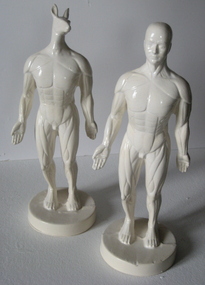 Federation University Art Collection
Ceramic - Sculpture, 'Platonic Friends' by Christopher Headley, c2009
Christopher HEADLEY Born York, England Arrived Australia 1974 Chris Headley studied at York School of Art before majoring in Ceramics at the Central School of Art in London, learning to throw with (the late) Michael Casson and hand-build with Gordon Baldwin. Chris graduated in 1973 and set out for Australia. He travelled overland across Europe and Asia, through Turkey, Afghanistan and Iran. He was invited to attend a traditional wedding in Pakistan by someone he made friends with on the bus trip from Isfahan to Teheran, got lost several times in India and ran out of money in Thailand. Eventually, a year after leaving England, he arrived in Australia, where he has lived and worked ever since. He undertook his Master’s degree at the Australian National University, graduating in 1991; and in 1999, with Dr Owen Rye as his supervisor, gained his PhD from Monash University, Victoria. (http://www.christopherheadley.net/#!about) While artist-in-residence at the Arts Academy, Federation University in 2009 Chris was spotted dragging his ceramic figures and photographic equipment across mullock heaps near Ullina, around Lake Wendouree and inside the Art Gallery of Ballarat where he was photographing Mount Warrenheip. These figures were used in the photographs. This item is part of the Federation University Art Collection. The Art Collection features over 2000 works and was listed as a 'Ballarat Treasure' in 2007.Two white earthenware glazed ceramic figures, one with a kangaroo head.art, artwork, christopher headley, ceramics, sculpture, artist in residence, figures -
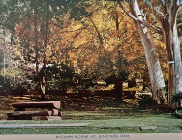 Falls Creek Historical Society
Postcard - Junction Dam, Kiewa Hydroelectric Scheme
These photographs were taken in and around Mount Beauty and the Kiewa Valley by Samuel Keith Pearce and printed for him as a foldout postcard by NuColor Vue. The postcards state they were printed for S. K. Pearce Pty. Ltd of Tawonga and Mount Beauty. Samuel Keith Pearce was born on 24 June 1917 in Armadale, Victoria. By the late 1940s he owned the Mt Beauty Supermarket, Newsagency, Drapery and Hardware store at Mount Beauty and also a store at Tawonga in partnership with his brother Gordon Cathew Pearce. For some time, they operated as Pearce Brothers. In the early 1960s Keith also opened a mini mart In Falls Creek. As well as being a keen photographer and an astute businessman, Keith Pearce was a well-known identity in the Kiewa Valley, making many contributions to the development of the area over a long period. This included serving as a member of the Bright Shire Council for many years. He worked hard to promote the interests of the Upper Kiewa Valley. As a sign of recognition and appreciation for his contribution to the community, the park opposite the grocery store in Mount Beauty was named the SK Pearce Gardens in his honour. Samuel Keith Pearce died on 7 July 1994 in Mount Beauty, Victoria Junction Dam, also known as Lake Guy, is situated 16 kms from Mt Beauty, along the Bogong High Plains Road. It was built by the State Electricity Commission of Victoria as part of the Kiewa Hydro Electric Scheme. This collection of postcards and images is significant because they were commissioned by a highly successful businessman in Falls Creek, Victoria.A colour image of Junction Dam in the Upper Kiewa area, showing a bench and autumn trees.mt. beauty, junction dam, lake guy, kiewa hydroelectric scheme -
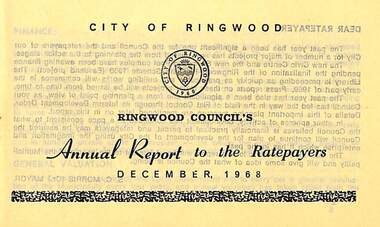 Ringwood and District Historical Society
Pamphlet, Ringwood Council's Annual Report To The Ratepayers - December 1968, 1968
City of Ringwood community information annual report for 1968, including sections covering Finance, General Valuation and Rater Payments, Property Ownership Changes, Refuse, Sanitary Serviced, Sewerage Connections to MMBW, Dandenong Valley Authority, Residential Flat Control Planning Scheme, Immunisation, Home Help, Elderly Citizens' Clubrooms, Library, Civic Centre, Golf Course, Sale of Council Land, Swimming Centre, Holiday Play Centre, Civic Week, Lake Reserve Improvements, Rubbish Dumping, Street Trees, Vandalism, White Ants, Street Construction, Fire Hazards, Dog Nuisance, House Numbering, Citizens' Advisory Service, Infant Welfare Centres, and a list of departing and current Council Representatives. Also includes general reminders regarding rat extermination, free firewood for age pensioners, overhanging vegetation, and spouses voting rights.Obituary - Mr. F.P. Dwerryhouse, Town Clerk for the past 9-1/2 years passed away on 6th December after a short illness.rinx -
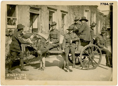 Bendigo Military Museum
Photograph - GROUP PHOTOGRAPHS WW1, Edgar Dawson Collection : Leave in Killarney Ireland March 1918
This three-photograph group is the fifth in a series of records of items in the collection of Edgar Dawson DCM. Dawson was the Regimental Sergeant Major of 57th Battalion, AIF. C Company of the 57th was composed of men drawn from Echuca, Eaglehawk and Bendigo. The postcards are from his personal album, and many are annotated in Dawson's hand with explanatory notes on the subject. Refer to Cat No 893 for his service details. Items originally in album cat. no. 207P These three photographs above portray various members of the AIF on leave in Killarney, Ireland. Three photographs taken by a commercial photographer in Killarney Ireland. These photographs illustrate how men from different units relaxed together on leave. 1. A group of AIF soldiers enjoying leave outside the Graham Hotel, Killarney. The soldier on left is a corporal in 2nd Division Pioneers, next to him is a private in the 1st Division, then a signaller from 5th Division with two years' overseas service chevrons and two wound stripes, RSM Hector Dawson, 57th Btn, then a Gallipoli veteran with what seems to be a Fifth Division patch, unknown, and lastly a 1st Division sergeant. 2. A relaxed group outside the Graham Hotel. RSM Dawson is third from the right. Second from the left is an officer of the Canterbury Infantry Regiment, New Zealand Expeditionary Force. 3. RSM Dawson (hatless) and comrades setting off to likely see the famous local lakes. Each photograph is inscribed on verso "To dear Mother and Father, with love from Heck, Killarney" with the date.postcards, 57th battalion, edgar dawson dcm -
 Bendigo Military Museum
Photograph - Various Photos - Army Headquarters Survey Regiment, Fortuna, Bendigo, c1950s to 1960s
This is a collection of five photographs taken at the Army Headquarters Survey Regiment, Fortuna Villa, Bendigo, circa 1950s to 1960s. Appearing in photo .3P is MAJ Edward Anderson MBE, who served from 1942 to 1977 and reached the rank of LTCOL. LT Frank Thorogood SB St J. served from 1960 to 1981. He reached the rank of LTCOL and was the CO of the Army Survey Regiment from 1980 to 1981. CAPT W. Greer’s service history is unknown. Appearing in photo .5P is MAJ Nolan, who served from 1939 to 1975. He was promoted to LTCOL and was the CO of the Army Headquarters Survey Regiment from 1965 to 1969. He was subsequently promoted to COL and was the Director of Military Survey from 1972 to 1975.This is a collection of five photographs taken at the Army Headquarters Survey Regiment, Fortuna Villa, Bendigo, circa 1950s to 1960s. The photographs were printed on photographic paper and are part of the Army Survey Regiment’s Collection. They were scanned at 300 dpi. .1) - Photo, black and white, 1950s. Regiment briefings by Fortuna’s lake. .2) - Photo, black and white, 1960s. Unidentified officer and civilian visitors in the Officers Mess. .3) - Photo, black and white, 1960s. L to R: MAJ Edward Anderson MBE, CAPT W. Greer and LT Frank Thorogood SB St J; in the Officers Mess. .4) - Photo, black and white, 1962. Regiment parade held in Fortuna’s grounds where the tennis and basketball courts were later developed. .5) - Photo, black and white, 1960s. MAJ John Nolan (centre) with unidentified civilian visitors.Personnel were identified in photos .3P and .5P. The date is annotated on photo .4P.royal australian survey corps, rasvy, army survey regiment, army svy regt, fortuna, asr -
 Kiewa Valley Historical Society
Book - Non Fiction History, The Kiewa Story, circa 1993
This book provides in chronological order the development of the Kiewa Hydro-electricity scheme from the first concept (1911) to final construction work (1961). It covers the first attempt to utilise the power of the Victorian Alps water system. It started from a private syndicate and developed to the current State Electricity Commission of Victoria. The incentive for the Hydro scheme was to make money and not as an alternative to the carbon producing coal fired power plants. These coal fired power plants were increasing in numbers to service an ever increasing demand made by population expansion, especially in cities and large rural settlements. This demand spiraled up after World War II when there was a tremendous spike in immigration numbers due to refugees and displaced persons in Europe. The ability to utilise the untapped water provided by the winter snow fields, for a higher yield in electricity, was a powerful incentive to overcome the physical hardships in this remote Alpine region. Future power requirements may initiate the re-installation of the other two power stations(Pretty Valley and Big Hill) covered in original Scheme. This publication not only covers the development of the Kiewa Valley region with respect to population (within a socio-economical framework) but also the subtle but yet strong physical changes of a relatively pristine alpine region. The demands that an ever growing regional population places on the environment is clearly documented in print and black and white photographs. The working and living conditions of those who constructed and gave life to this hydro scheme is well documented in this book. It may be viewed as spartan now but was relevantly good at that moment in time, especially for those workers fleeing a devastated European environment. The successful planning and consideration to minimising any intrusion upon the natural alpine forests and high plains can viewed as an example (compared to the Tasmanian Hydro schemes) of how future hydro schemes (an inevitable requirement) will proceed. Most rural towns (in the early 1900s) were built by unencumbered rural based citizens, with the exception of Mount Beauty and Falls Creek. These two settlements were brought into life by a State (Victorian) Authority for a specific function and program. They were a gated community, that is, only open to construction workers involved with the hydro scheme. All facilities within these communities were provided by the State Electricity Commission of Victoria. The impact on the social, financial and individual independency of the community, by the transition from the S.E.C .environment to one of local government (Shire of Bright), had in some cases a severe impact.This hard covered book has a green cover with pictures on the front and back covers. The front cover has a coloured picture of a snow covered Mount Bogong taken from the opposite mountain range. The valley between both ranges has a whisk of mist over it. At the bottom of this picture are three black and white photographs covering the construction of the Kiewa Hydro - Electricity Scheme. On the back cover is a photograph, (black and white) detailing the Bogong village and Junction dam containing lake Guy. The inside front cover is a black and white photograph which details the construction of the West Kiewa tailrace tunnel during April 1951. The inside back cover is a black and white photograph of the concrete pour at the Clover Dam circa 1952. All photographs and sketches are in black and white. The pages are approximately 160 g/m2 and those which have photographs are on gloss paper.Book spine: "The Kiewa Story Graham Napier Geoff Easdown" alongside this is a white framed circle with white spokes radiating out and underneath in white lettering SECkiewa valley, hydro scheme, victorian alpine region, electricity generators, graham napier, geoff easdown -
 Bendigo Historical Society Inc.
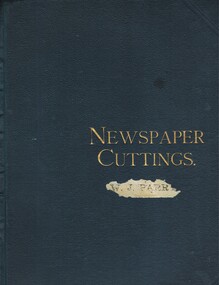
Document - J.W. PARRY COLLECTION: NEWSPAPER CUTTINGS AND ASSORTED CARDS, 1892-1923
COLLECTION OF NEWSPAPER CUTTINGS AND ASSORTED CARDS (J W Parry, Draper & Sec. of Bendigo Progress Association & Chamber of Commerce). Cuttings in sections: Personal; Scientific; Masonic, including programmes [There are two sections on Masonry and large amount of material of interest in that regard T.D.]; Humorous. Note: Pages 64, 65 - article, photographs (Advertiser) re Opening of Upper Lake Reserve Water Chute - including Admission Ticket; Tickets to: 1. Complimentary send-of and Presentation to Mr Murdoch Robertson 9/7/?/; 2. Grand Concert, Miss E Morcombe (soprano) 16/7/1909; 3. Complimentary Banquets and Reception - Royal Welsh Male Choir at close of concert - 7/11/?? Although this is catalogued in the 1200 series [Basil Watson) there is no obvious connection with Basil Watson or family - possible connection with collector (K Munro) of Watson collection?? [T.D.]person, individual, bendigo citizen (man-woman) -
 Victorian Interpretive Projects Inc.
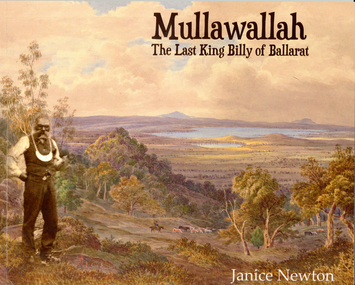
Book, Janice Newton, 'Mullawallah: The Last King Billy of Ballarat' by Janice Newton, 2015
Dr Janice Newton has had a long term interest in Indigenous Studies and Aboriginality, and has published papers linking Aboriginality to the counterculture and to artists and musicians. She has published a paper commenting on Ballarat's response to the death in 1896 of King Billy, the so called 'last of his tribe'. Janice has recently taught courses on 'The Anthropology of Indigenous Art' and 'Indigenous History' at Federation University Australia.56 page soft covered booklet outlining the life of Ballarat's Mullawallah (also known as King Billy or Frank Wilson). Numerous photographs. The book 'Mullawallah: The Last King Billy of Ballarat' is an initiative of Victorian Interpretive Projects. It is available for purchase for $15.00 (additional for postage). Please email [email protected] for further details. Images include: Ercildoun, Lake Burrumbeet, Lal Lal Falls, William Buckley, Warrenheip, King Billy and his Camp in McCree's Paddock, King Billy and His Tribe, Carl Walter King Billy, Mary of Carngham, Rosa of Carngham, King Billy (Bullip Bullip), Queen Mary of Buninyong, Queen Marie of Ballarat, Queen Mary and King Billy and their original mia mia, Football at Ercildoune, Thomas Jerusalem, Samuel Wilson, Frank the last of the Ballarat Tribe, The Burial of King Billy, King Billy's Grave. mullawullah, frank wilson, king billy, aborigines, wathauwrung, wadawurrung, aboriginal, ercildoun, ercildoune, lake learmonth -
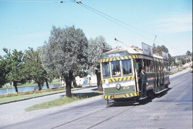
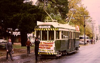 Ballarat Tramway Museum
Photograph - Digital image Set of 3, Chris Phillips, 30/05/1971 12:00:00 AM
Yields information about the special tram and the people involved at the time of the formation of the BTPS prior to closure of the SEC operated system.Set of three digital images of tram 36 advertising the Lake Tramway Preservation Meeting at the Town Hall 31/5/1971 by Chris Phillips. .1 - tram at Gardens loop with the motorman L Bird pulling the pole down - similar photo to that of The Age Newspaper, see Reg Item 2487. .2 - tram turning from Sturt St into Lydiard St North with the Post Office and the Mining Exchange buildings in the background. .3 - tram at the City stop, south side of Sturt St with the Town Hall and Myers in the background. Also has the tram stop signs in the photograph. See also Reg Item 1064 for the newspaper clipping, 2487 for a print of The Age photograph. See 7033i4 for notes on the tram and who made the banner - thought to be Tom Clark. Imagebtm7033i2bw - black and white version of the slide use in the Long Gallery imagebtm7033i2co - colour hi res scan.trams, tramways, lake wendouree, charters, museum establishment, btps, sturt st, gardens, lydiard st north -
 Ballarat Tramway Museum
Photograph - Black & White Photograph/s - set of 6, Charles Craig, 1950s
Yields information about the appearance and use of the Ballarat Railway Station level crossing by trams prior to closure.Set of six black and white photographs of trams at the railway level crossing, Ballarat, Lydiard St North featuring the railway station, gates and signals, Reeds Coffee Palace and the Provincial Hotel. .1 - 28 heading south, with an R class and a K class locomotive in the view. .2 - 11, heading north - taken during the 1950's. .3 - 17 parked right up to the gates while K184 shunts at the station. .4 - single trucker (number obscured) - most likely 17 giving the passengers in the previous photo. .5 - Photo with two single truckers in the view and the gates being closed after the tram has passed. .6 - 11, at the gates with a bogie tram behind. No. 11 has a Briquettes roof advert and a Twin Lakes sign. Photo by Charles Craig - during 1971, except for .2, taken during the 1950's. trams, tramways, lydiard st north, railway station, signals, level crossings, tram 28, tram 11, tram 17 -
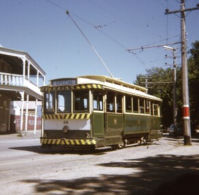
 Ballarat Tramway Museum
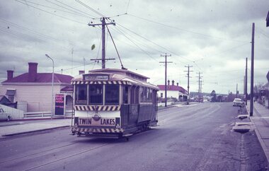
Photograph - Black & White Photograph/s - set of 5 - tram operations on the Victoria St, Richard Gilbert, c August 1971
Yields information about the appearance of the Victoria St line shortly before the closure of the Victoria St line. Series of 5 Black and white photographs of tram operations on the Victoria St line prior to its closure in August 1971. .1 - View of the Victoria St terminus as you arrive in Ballarat from Melbourne, with the divided highway and a tram warning sign. Has a tram at the terminus. .2 - Tram 39, running a special tour with St Alipius church in the background. A new bus stop sing has been positioned. Another tram has departed the King St loop. .3 - No. 13, (Gardens via Sturt St West and a Twin Lakes sign) entering the King St loop. .4 - No. 31 (to Gardens crossing No. 39) at the King St loop. .5 - No. 31 leaving Stones Corner for Victoria St with Stones Corner building in the background along with the Caltex service station and Viscount Ambassador caravans.trams, tramways, victoria st, king st, stones corner, tram 39, tram 13, tram 31 -
 Ballarat Tramway Museum
Film - Video cassette tape and box, Ballarat Nine News Network and Alan Snowball, "Ballarat City Tramway Plan", 11/07/2002 12:00:00 AM
VHS cassette and cardboard box, black plastic, with white insert cover, and labels on cassette and VHS video tape. Contains recording of the Ballarat Nine Network news service of 11/7/2002 reporting on the previous nights Ballarat Council Meeting receiving the report on the Ballarat City Tramway proposal. 00.00 to 15.50 - general items from previous shows 1550 - 1620 - News headlines and notes at 1620, headline regarding the Ballarat City tramway and short video clip of a tram. 1620 - 2410 - news, bomb hoaxes, Johns Valves industrial problems etc. 2410 - 2535 - report on Ballarat Council meeting the previous nights, interviews with the Mayor David Vendy, Austin Brehaut and Alan Snowball. Mentions BTM and operation at Lake Wendouree. 2535 - onwards - report on the Stoddart Statue collection at the gardensOn box and tape label, notes re tape size and AS (Alan Snowball) number.btm, city tramway, video tape, news broadcasts -
 Ballarat Tramway Museum
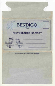
Postcard - Folder set, Valentine & Sons Publishing Co, "Bendigo Photographic Booklet", 1940's
Set of 9 black and white views of Bendigo printed on a folded strip, glued within a light grey colour light weight cardboard folder, titled "Bendigo Photographic Booklet". Booklet printed with an address area with title and kookaburras. Produced by The Valentine Publishing Co. Pty Ltd Melbourne & Sydney The rear has a slit on the rear cover that allowed the folder to be secured. Pictures are: 1. Mitchell St 2. The Lookout Tower 3. Conservatory Gardens 4. Shamrock Hotel 5. The Lake, Upper Reserve 6. The Pall Mall 7. Civic Buildings 8. Soldiers Memorial Hall and Post Office 9. Alexandria Fountain, Bendigo with a single trucker, M class type tram, prior to alterations, but in SEC colour scheme of the mid 1930's Made during 1940, with photographs of the 1930's as well given motor cars in the photo. Has "D. Gilbert" in ink on cover.trams, tramways, bendigo, pall mall, charing cross, mitchell st -
 Ballarat Tramway Museum
Slide - 35mm slide/s - set of 3, Dave Simpson, late 1960's early 1970's
Yields information about Barkly St Mt PleasantSet of three 35mm slides - AGFA dark blue / white plastic mounts or a Anscochrome white plastic slide of trams in Barkly St, Mount Pleasant. .1 - No. 11 inbound to Gardens via Drummond St, with the Ballarat Fire station in the distant background. Tram has a Twin Lakes sign on the rear. On the left hand side is a sign for "Mobil Anti wear" petrol. .2 - No. 11 inbound to Gardens via Drummond St, at the intersection with Grant St. On the left hand side is a Butchers shop and a Milk bar mixed Grocery shop. The shop has a advert for Woman's Weekly. Along side the shop is a letter box and telephone Box. The tram stop sign has a "End of Section" sign. A lady is boarding the tram. .3 - View form the top of the hill looking East towards Main Road with the Fire Station in the Background. Has a tram in the distance.tramways, trams, barkly st, grant st, mt pleasant, fire station, tram 11 -
 Ballarat Tramway Museum
Slide - 35mm slide/s - set of 11, Eldon Hogan, mid 1960's to early 1970's
Set of 11 Agfa Plastic mounted slides - from the Eldon Hogan collection - featuring an ARE tour with Nos. 21, 29 and 25 to Bendigo, mid 1960's. Scanned on the Canon scanner at the depot 15/12/1971 at the time of the installation of the scanner. .1 - No. 29 passing the Institute of Technology building, McCrae St. .2 - ditto .3 - Nos. 21 and 29 Lake Weeroona .4 - Nos. 29, 21 and 25 at the Golden Square Terminus with the Golden Square Hotel, Victoria Bitter fence in the background. .5 - ditto with a service car? .6 - ditto .7 - No. 21 with the Central Deborah mine poppet head in the background, Violet St. .8 - ditto with 21 and 29 .9 - ditto with 29 .10 - ditto with 21 and 29 .11 - 21, 29 and 25? at depot junction. Trams have SEC roof advertisements. tramways, trams, bendigo, lake weeroona, golden square, central deborah, tram 21, tram 29, tram 25 -
 Ballarat Tramway Museum
Slide - 27 mm sq slide/s - set of 5, Andrew Howlett, Tram 26 on private tour - View Point line, Mar. 1969
Yields information about a special tram service during March 1969 and some unusual moves.Set of four Colour slides, Kodak white cardboard mount, developed March 1969 of a special tram that apparently ran from the depot via View Point, shunted at Ripon St and again at Hospital corner. ..1 - No. 26 running a special in Wendouree Parade, View Point, with the Lake View Hotel. .2 - ditto - and a catering company in the view, as well as a Telephone box. .3 - running from Ripon St into Sturt St. .4 - shunting at Hospital corner - then possibly crossed 34 at Parker St Loop - see 7668. .5 - ditto, but before .4, with the tram rounding the corner from the North side of Sturt St into Drummond St. It would then appear that the tram then reversed a bit before going back into Sturt St onto the South side. One of a series of tour photos - see Reg item 7667, 7668, 7683 and 7701.ballarat, tramways, trams, view point, wendouree parade, ripon st, hospital corner, sturt st, tours, tram 26 -
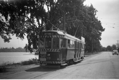 Ballarat Tramway Museum
Photograph - Black and White photocopy, Travis Jeffrey, 1961
Negative No. N387 and black and white print made by a laser printer (stored in folder) of Ballarat No. 39 passing depot junction, in 1961. Tram fitted with lights and small white stripe. Small triangles in corners of front dash. Ad for 60/40 dancing at Civil hall on front of tram. Showing Victoria Street destination. Lake in background, no other vehicles. Photo by Travis Jeffrey, who advised could be Dave Kellett driving. Date of photo on folder 5/9/1960. Date of photo could be incorrect, due to fitting of lights taking place late 1960. Large print of this photo made for display 1995c. Item updated when negative added to collection - 1/6/2003. Original negative rescanned 24/5/2020 and image file updated. Paper print of original photo in folder 73.Paper folder that contained the negative had "NR40A" in red ink, "BA14" in pencil, date stamp of "5 Sep 1960" on front, and on rear date stamps "26 Sep 1962" and "6 Oct 1962".trams, tramways, ballarat, wendouree parade, tram 39 -
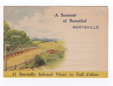
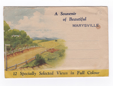 Marysville & District Historical Society
Postcard (item) - Colour photographs, Nucolorvue Productions, A Souvenir of Beautiful Marysville-12 Specially Selected Views in Full Colour, 1950's
An envelope of 12 colour photographs of attractions in and around Marysville in Victoria.An envelope of 12 colour photographs of attractions in and around Marysville in Victoria. These photographs were produced by Nucolorvue Productions in Mentone, Victoria.A Souvenir of Beautiful MARYSVILLE 12 Specially Selected Views in Full Colour Marysville, Victoria, Australia Marysville, 60 miles from Melbourne, is one of nature's/ lovely beauty spots. The invigorating mountain air helps the/ visitor to enjoy the many delightful walks amongst the tall/ timber, or through the fern glades. Apart from many excellent walking trips, Marysville district/ offers ample scope for car trips to the nearby Cumberland Forest,/ Buxton, Narbethong, or the Taggerty Valley. Skiers find Lake Mountain an attraction in the winter, whilst/ the hiker finds ample for his needs in the numerous mountain/ areas. Huge Eucalypt trees, revealing their ramrod straightness up/ to 300 feet in height, are a fitting background to the many/ beautiful creeks and waterfalls. PUBLISHED BY NUCOLORVUE PRODUCTIONS, MENTONE, VICTORIA.nicholl's lookout (image 1), eildon weir (image 2), road to lake mountain (image 3), foot of steavenson falls (image 4), steavenson falls (image 5), bush scene near marysville (image 6), bush track marysville (image 7), bridge and chalet and crossways marysville (image 8), log cabin at marysville (image 9), black spur (image 10), taggerty river (image 11), highest known hardwood tree (image 12), marysville, victoria, nucolorvue productions, postcard, souvenir -
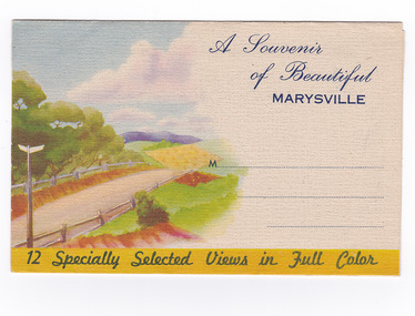
 Marysville & District Historical Society
Postcard (item) - Colour photographs, Nucolorvue Productions, A Souvenir of Beautiful Marysville-12 Specially Selected Views in Full Colour, Unknown
An envelope of 12 colour photographs of attractions in and around Marysville in Victoria.An envelope of 12 colour photographs of attractions in and around Marysville in Victoria. These photographs were produced by Nucolorvue Productions in Mentone, Victoria.A Souvenir of Beautiful MARYSVILLE 12 Specially Selected Views in Full Colour Marysville, Victoria, Australia Marysville, 60 miles from Melbourne, is one of nature's/ lovely beauty spots. The invigorating mountain air helps the/ visitor to enjoy the many delightful walks amongst the tall/ timber, or through the fern glades. Apart from many excellent walking trips, Marysville district/ offers ample scope for car trips to the nearby Cumberland Forest,/ Buxton, Narbethong, or the Taggerty Valley. Skiers find Lake Mountain an attraction in the winter, whilst/ the hiker finds ample for his needs in the numerous mountain/ areas. Huge Eucalypt trees, revealing their ramrod straightness up/ to 300 feet in height, are a fitting background to the many/ beautiful creeks and waterfalls. PUBLISHED BY NUCOLORVUE PRODUCTIONS, MENTONE, VICTORIA.nicholl's lookout (image 1), eildon weir (image 2), road to lake mountain (image 3), foot of steavenson falls (image 4), steavenson falls (image 5), bush scene near marysville (image 6), bush track marysville (image 7), bridge and chalet and crossways marysville (image 8), log cabin at marysville (image 9), black spur (image 10), taggerty river (image 11), highest known hardwood tree (image 12), marysville, victoria, nucolorvue productions, postcard, souvenir -
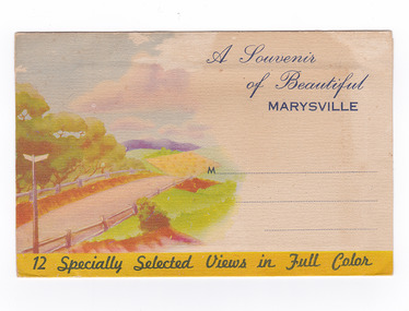
 Marysville & District Historical Society
Postcard (item) - Colour photographs, Nucolorvue Productions, A Souvenir of Beautiful Marysville-12 Specially Selected Views in Full Colour, Unknown
An envelope of 12 colour photographs of attractions in and around Marysville in Victoria.An envelope of 12 colour photographs of attractions in and around Marysville in Victoria. These photographs were produced by Nucolorvue Productions in Mentone, Victoria.A Souvenir of Beautiful MARYSVILLE 12 Specially Selected Views in Full Colour Marysville, Victoria, Australia Marysville, 60 miles from Melbourne, is one of nature's/ lovely beauty spots. The invigorating mountain air helps the/ visitor to enjoy the many delightful walks amongst the tall/ timber, or through the fern glades. Apart from many excellent walking trips, Marysville district/ offers ample scope for car trips to the nearby Cumberland Forest,/ Buxton, Narbethong, or the Taggerty Valley. Skiers find Lake Mountain an attraction in the winter, whilst/ the hiker finds ample for his needs in the numerous mountain/ areas. Huge Eucalypt trees, revealing their ramrod straightness up/ to 300 feet in height, are a fitting background to the many/ beautiful creeks and waterfalls. PUBLISHED BY NUCOLORVUE PRODUCTIONS, MENTONE, VICTORIA.nicholl's lookout (image 1), eildon weir (image 2), road to lake mountain (image 3), foot of steavenson falls (image 4), steavenson falls (image 5), bush scene near marysville (image 6), bush track marysville (image 7), bridge and chalet and crossways marysville (image 8), log cabin at marysville (image 9), black spur (image 10), taggerty river (image 11), highest known hardwood tree (image 12), marysville, victoria, nucolorvue productions, postcard, souvenir -
 Marysville & District Historical Society
Postcard (item) - Colour photographs, Nucolorvue Productions, A Souvenir of Beautiful Marysville-12 Specially Selected Views in Full Colour, Unknown
An envelope of 12 colour photographs of attractions in and around Marysville in Victoria.An envelope of 12 colour photographs of attractions in and around Marysville in Victoria. These photographs were produced by Nucolorvue Productions in Mentone, Victoria.A Souvenir of Beautiful MARYSVILLE 12 Specially Selected Views in Full Colour Marysville, Victoria, Australia Marysville, 60 miles from Melbourne, is one of nature's/ lovely beauty spots. The invigorating mountain air helps the/ visitor to enjoy the many delightful walks amongst the tall/ timber, or through the fern glades. Apart from many excellent walking trips, Marysville district/ offers ample scope for car trips to the nearby Cumberland Forest,/ Buxton, Narbethong, or the Taggerty Valley. Skiers find Lake Mountain an attraction in the winter, whilst/ the hiker finds ample for his needs in the numerous mountain/ areas. Huge Eucalypt trees, revealing their ramrod straightness up/ to 300 feet in height, are a fitting background to the many/ beautiful creeks and waterfalls. PUBLISHED BY NUCOLORVUE PRODUCTIONS, MENTONE, VICTORIA.nicholl's lookout (image 1), eildon weir (image 2), road to lake mountain (image 3), foot of steavenson falls (image 4), steavenson falls (image 5), bush scene near marysville (image 6), bush track marysville (image 7), bridge and chalet and crossways marysville (image 8), log cabin at marysville (image 9), black spur (image 10), taggerty river (image 11), highest known hardwood tree (image 12), marysville, victoria, nucolorvue productions, postcard, souvenir