Showing 2217 items
matching railway line
-
 Wodonga & District Historical Society Inc
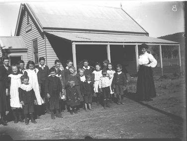
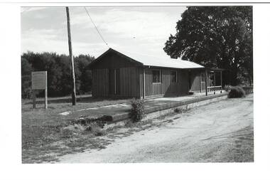
Negative - Haeusler Glass Negatives Collection - Teachers and Students Wodonga West Primary School
... an older school north of the railway line. It operated from January... an older school north of the railway line. It operated from January ...The Wodonga Historical Society Haeusler Collection provides invaluable insight into life in late nineteenth and early twentieth century north east Victoria. The collection comprises manuscripts, personal artefacts used by the Haeusler family on their farm in Wodonga, and a set of glass negatives which offer a unique visual snapshot of the domestic and social lives of the Haeusler family and local Wodonga community. The Haeusler family migrated from Prussia (Germany) to South Australia in the 1840s and 1850s, before purchasing 100 acres of Crown Land made available under the Victorian Lands Act 1862 (also known as ‘Duffy’s Land Act’) in 1866 in what is now Wodonga West. The Haeusler family were one of several German families to migrate from South Australia to Wodonga in the 1860s. This digital image was produced from one of the glass negatives that form part of the collection, probably taken by Louis Haeusler (b.1887) with the photographic equipment in the Wodonga Historical Society Haeusler Collection. This item is unique and has well documented provenance and a known owner. It forms part of a significant and representative historical collection which reflects the local history of Wodonga. It contributes to our understanding of domestic and family life in early twentieth century Wodonga, as well as providing interpretative capacity for themes including local history and social history.Digital image created from the Haeusler Glass negative collection. A group of students with their teacher standing outside their school building at Wodonga West, Victoria No. 1058. The school was located near the current intersection of McKoy Street and the Hume Freeway in West Wodonga on land donated by J.W. Klinge, replacing an older school north of the railway line. It operated from January 1870 to May 1950 when the nine remaining students transferred to Wodonga Primary School.wodonga pioneers, haeusler family, glass negatives, dry plate photography, wodonga west primary school -
 City of Kingston
Photograph - Colour, 31 January 1993
... , Kananook Creek and Nepean Highway. The railway line can be seen... and Nepean Highway. The railway line can be seen as it veers inland ...Patterson Lakes is a suburb in the City of Kingston that is built one kilometre upstream of the mouth of the Patterson River. The area is bordered by the Patterson River and Eel Race Drain which enters the Kananook Creek. The suburb consists predominantly of newer housing developments and the tidal canal system of the development joins Port Phillip Bay. Patterson Lakes and the Kananook Creek were previously part of the extensive Carrum Carrum Swamp. The area was once a source of fish and eels for the Mayone-Bulluk clan of the Bunurong people. Over time the area was drained and in 1973 investigations commenced into the development of a unique residential area that would be built adjacent to canals and waterways. It was originally proposed to be known as "Gladesville". The development would give the suburb's homeowners access to Port Phillip Bay "from their back door". Circa 1974, the area was rezoned from rural to residential and named Patterson Lakes. Development has been continuous since the 1970s with construction of residential housing, schools, shopping centres, marinas, a hotel and library.Laminated colour aerial photograph of the Carrum and Patterson Lakes region within City of Kingston. This 1993 image includes Patterson River Secondary College, Roy Dore Reserve, Kananook Creek and Nepean Highway. The railway line can be seen as it veers inland from Eel Race Road, Seaford. The section of Ocean Reef Drive and Palm Beach Drive in Patterson Lakes appears to be a recent development with many spare blocks and new houses under construction.Black typed lettering on white adhesive label: 31.1.93 Black typed lettering on white adhesive label: 27E/7140 31/1/93 12.55 pm Black typed lettering on white label: 7140 Yellow round adhesive label located on left sidepatterson lakes, seaford, kananook creek, carrum carrum swamp, canals and waterways -
 Greensborough Historical Society
Newspaper clipping, Greensborough shopping centre 1970, 1970_
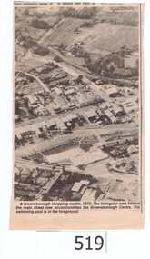
... be seen north of the Railway Line. Alan and Wyn had to leave...) can be seen north of the Railway Line. Alan and Wyn had ...The photograph is of the centre of Greensborough in 1970, prior to the Greensborough Plaza being built. The Partington farm house, named 'Alwyn' (after Alan and Wyn Partington) can be seen north of the Railway Line. Alan and Wyn had to leave this farm in 1976 - moving to a new house - built by son Gary - at 54 Manatunga Circuit - to make way for the creation of Whatmough Park and development of the Hailes Street-The Circuit-Greensborough Plaza precinct.This is an important visual record of Greensborough before the redevelopment of the late 1970's. It also shows the Whatmough park area when it was still the Partington family farm.A black and white newspaper clipping featuring an aerial photograph.Nilgreensborough streets, greensborough, aerial photograph, 1970, partington, whatmough park, greensborough swimming pool -
 City of Whittlesea
Badge - Badges - Advocacy Campaign, Access Denied, 2014
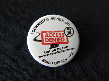
... political parties to commit to extending the railway line from South... political parties to commit to extending the railway line from South ...Access Denied was a joint advocacy campaign between the City of Whittlesea and the local community in the lead up to the 2014 Victorian State Election. The campaign called on all political parties to commit to extending the railway line from South Morang to Mernda and building access ramps on the Hume Freeway at O’Herns Road in Epping North. The campaign was a success and secured almost $650 million in promises from the incoming Labor Government to build these projects. Badge, metal back with pin, white plastic printed front, black and red textConnect O'Herns Road / Access Denied / Get on Board / www.accessdenied.net.au / Build Mernda Railbadges, campaign badges, south morang railway, mernda railway -
 Melbourne Tram Museum
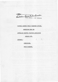
Document, Australian Electric Traction Association (AETA), "AETA submission - Victoria Harbour", Jan. 1990
... railway line, ferries, monorails, and car parking. Signed by Ken... and Bourke St routes and suggestions re the Webb Dock railway line ...Submission from Australian Electric Traction Association (AETA) dated Jan. 1990 about public transport options to Victoria Harbour, Melbourne docklands. Gives options for extension of Flinders St (tram route 48) or Collins St. Includes notes on La Trobe and Bourke St routes and suggestions re the Webb Dock railway line, ferries, monorails, and car parking. Signed by Ken Craven. Includes two diagrams.Yields information about the AETA's work and a 1990 submission re Victoria Harbour Docklands.Photocopy of a 5 page A4 document, was stapled in top left hand cornertramways, trams, aeta, docklands, new tramways, submissions, victoria harbour -
Melbourne Tram Museum
Document, Australian Electric Traction Association (AETA), "AETA submission - Victoria Harbour", Jan. 1990
... railway line, ferries, monorails, and car parking. Signed by Ken... and Bourke St routes and suggestions re the Webb Dock railway line ...Submission from Australian Electric Traction Association (AETA) dated Jan. 1990 about public transport options to Victoria Harbour, Melbourne docklands. Gives options for extension of Flinders St (tram route 48) or Collins St. Includes notes on La Trobe and Bourke St routes and suggestions re the Webb Dock railway line, ferries, monorails, and car parking. Signed by Ken Craven. Includes two diagrams.Yields information about the AETA's work and a 1990 submission re Victoria Harbour Docklands.Photocopy of a 5 page A4 document, was stapled in top left hand cornertramways, trams, aeta, docklands, new tramways, submissions, victoria harbour -
 Kew Historical Society Inc
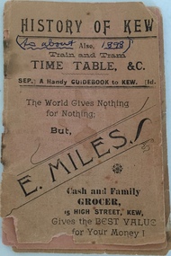
Booklet, H Sharpe Patterson, History of Kew; also Train and Tram Timetable, &c, c.1898
... -1914) and the Kew Railway Line (1887-1952). The Kew section...-1914) and the Kew Railway Line (1887-1952). The Kew section ...Train timetable including a history of Kew and advertisements for local retailers and merchants. Given the frequency of times mentioned, Coopers Kew Flyer may have been the distributor and producer. There is no indication that it is an official tram or railway publication. During the second half of the 19th century when the booklet was produced there was only a horse tram (1887-1914) and the Kew Railway Line (1887-1952). The Kew section of the Outer Circle Line functioned until 1893.Historically significant item documenting Kew's history in the 19th century. The item is the earliest piece in the collection documenting aspects of the Kew Railway Line.Small 30-page booklet containing a train and tram timetable for public transport in Kew (Vic). The booklet also contains a brief history of Kew and advertisements for local retailers. Pages can be viewed by scrolling through the attached images."Gift of C.W. Fairhall, Box Hill, 1990"kew (vic) - history, public transport - kew (vic), train timetables, tram timetables -
 Wodonga & District Historical Society Inc
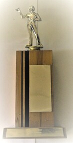
Award - Darts Trophy - A.W.D.D.A 1992 A Grade Premiers
... in Wodonga, with clear links to the establishment of the railway line..., with clear links to the establishment of the railway line ...The Terminus Hotel was one of the earliest hotels in Wodonga, with clear links to the establishment of the railway line. It was an important business and meeting place from the original construction in 1873 until 1st June 1998 the Terminus Hotel when it was destroyed by fire. It provided a popular venue for social activities, including competitive darts, both through its own competition and as part of the Albury-Wodonga District Darts Association. The remains of the building were demolished in 1999. The Terminus Hotel was an important meeting place in Wodonga for more than 100 years. This item is representative of one of the social and sporting activities it provided for members of the local community.A wood and metal trophy with a figurine of a darts player mounted on the top and a metal panel engraved with players' names.At base of trophy: "A.W.D.D.A 1992 / A GRADE PREMIERS / TERMINUS ALBURY" On front of trophy, top to bottom " J. DEKRUIFF (C) B. TINGWELL S. HONG L. SIMS S. GRIFFITHS A. GARDNER R. GARDNER'terminus hotel wodonga, terminus hotel darts, sport and recreation wodonga -
 Melbourne Tram Museum
Pamphlet - Real estate sale, T M Burke, "New Suburban line - Darling to Glen Waverley", July 1926
... of the recommendation to extend the railway line from Darling to Glen Waverley... to extend the railway line from Darling to Glen Waverley, extracted ...Pamphlet advising potential land purchasers of the recommendation to extend the railway line from Darling to Glen Waverley, extracted from The Age 26/6/1926. Advises that the land and losses would be paid for by the residents through their rates. Gives costs of the proposed new line. Has a plan showing the estates for sale along the line, the Ashburton line (later extended to Alamein) and Burwood Road. Published by T M Burke Pty Ltd. Demonstrates the style of land sale pamphlet including the proposed availability of train services to prospective purchasers.Pamphlet - single quarto sheet with map on rear - printed.sale of land, real estate, railways, glen waverley, suburban railways -
 Federation University Historical Collection
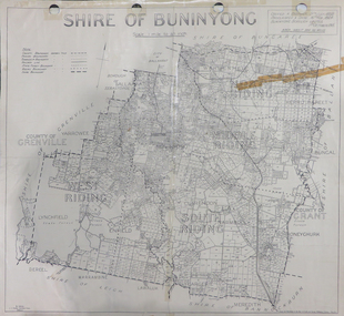
Map, Shire of Buninyong, c1970
... the County divisions, township boundaries, Railway line, State Forest...) Map showing the County divisions, township boundaries, Railway ...The Shire of Buninyong was located on the southern side of Ballarat.Two maps of the Shire of Buninyong. .1) Map showing the County divisions, township boundaries, Railway line, State Forest boundary, riding boundary and shire boundary. Identifying words have been added in red and green texta. .2) Shire of Buninyong Parish Plan. Includes Buninyong, Clarendon, Narmbool, Enfield, Lychfield, SCotchman's, Navigators, Warrenheip, Scotsburn, mr Doran, Durham Lead, Cambrian Hill, Napoleons, Garibaldi, Mt Clear, Lal Lal, Bonshaw.1) B.I.A.E., St Martin's, cemetery, mt Buninyong, mt Innes, rly stn shire of buninyong, buninyong, clarendon, narmbool, enfield, lychfield, scotchman's, navigators, warrenheip, scotsburn, mt doran, durham lead, cambrian hill, napoleons, garibaldi, mt clear, lal lal, bonshaw, state forest, elaine, elaine north, cargerie, grenville, mt mercer, millbrook, wallace, yendon, canadian, kaolin deposits, mount helen campus -
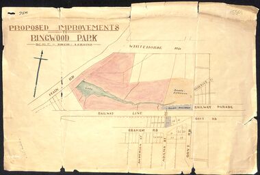 Ringwood and District Historical Society
Map, Proposed Improvements to Ringwood Park (Ringwood Lake) dated 14 January 1927
... of the map, south of the railway line, showing proposed streets... in 2024. On the bottom of the map, south of the railway line ...Proposed Improvements to Ringwood Park (Ringwood Lake) dated 14 January 1927, signed Cr McCaskill. Main Road is Whitehorse Road (Maroondah Highway), and Mt Dandenong Road is incorrectly labelled Whitehorse Road. The map shows Rosedale Crescent and Railway Parade, both of which exist in 2024. On the bottom of the map, south of the railway line, showing proposed streets - Graham Road, Anderson Street and Adams Street - in preparation for the sale of the Theo Anderson property. That area is now Bedford Park. -
Bendigo Historical Society Inc.
Map - CAMPBELL COLLECTION: BENDIGO AND DISTRICT MAPS, 8-7-29
... . Wallan and Bendigo Railway line. Rifle Range. Axedale township... by Planimeter 5916 acres. Wallan and Bendigo Railway line. Rifle Range ...Map. Rifle Range, Parishes of Wellsford and Sandhurst. Scale 20 chains to 1 inch. Total area by Planimeter 5916 acres. Wallan and Bendigo Railway line. Rifle Range. Axedale township and station 8 miles. To Longlea Ryl station 2 1/2 miles. To Epsom 1 1/2 miles. To Bendigo 3 miles. Compiled in W.P.D. from Assessment and Parish Plans by H.A.D 8-7- 29 (number 367 in map cupboard 1)H.A.D.(H.A.Darby)map, bendigo, allotments -
Bendigo Historical Society Inc.
Map - HEATHCOTE : COUNTY OF BENDIGO
... Railway Line, Township of Heathcote, C.R.B. Main Road. Mount Ida..., Bendigo to Heathcote to Kilmore Railway Line, Township ...Map. Heathcote, County of Bendigo, County of Dalhousie, Knowsley, Knowsley East, Dargile, Costerfield, Warrowitue, Tooborac, Langwornor, Argyle Station Ground, Bendigo to Heathcote to Kilmore Railway Line, Township of Heathcote, C.R.B. Main Road. Mount Ida Creek, Wild Duck Creek, Meadow Valley Creek. By Authority H.J. Green, Govt. Printer, Photo-Lithographed at the Department of Lands and Survey, Melbourne by W.J. Butson, Price 1/-. (number 91 in map cupboard 1)H.J. Green Govt. Printer.map, bendigo, heathcote -
Bendigo Historical Society Inc.
Document - MINING REPORTS - MAP OF PART OF THE BENDIGO GOLDFIELD INCLUDING WHITE HILLS AND EAGLEHAWK
... and Eaglehawk. Map shows reef lines, gullies, railway line, tram route..., gullies, railway line, tram route, type of rock, name of mine ...BHS CollectionMap of part of the Bendigo Goldfield including White Hills and Eaglehawk. Map shows reef lines, gullies, railway line, tram route, type of rock, name of mine, Calls and Dividends. Also Deepest Mine Victoria Quartz 4614 ft. Names of Mines are Garden Gully United, Great Ext'd Hustlers, Johnson's Reef, South New Moon, New Moon, Catherine Reef, Virginia, Central Red White & Blue, Ironbark, Kock's Pioneer, Carlisle and the Hercules & Energetic.document, gold, mining reports, mining reports, map of part of the bendigo goldfield including white hills and eaglehawk, pabst bendigo goldfield, garden gully united, great ext'd hustlers, johnson's reef, south new moon, new moon, catherine reef, virginia, central red white & blue, ironbark, kock's pioneer, carlisle, hercules & energetic. victoria quartz -
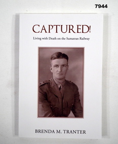 Bendigo Military Museum
Book - BIOGRAPHY - WW2, Brenda M Tranter, "CAPTURED! LIVING WITH DEATH ON THE SUMATRAN RAILWAY", 2022
... with railway line and sleepers. 168 pages, cut, plain white paper... - colour photograph two wreaths with railway line and sleepers. 168 ...'"ARTHUR EDMUND TRANTER" Enlisted on 20/11/1939 Regt No. V50166 in the CMF, posted to 2nd Training Bn Balcombe. Discharged from the CMF 16/12/1940 with the rank of Sergeant in 2/7 Training Battalion. Enlisted in the 2nd AIF 17/12/1940 Regt No. VX52843 in 2/29th Battalion at Darnley Camp, embarked for Singapore 13.9.1941, disembarked 5.10.1941, reported missing 16.2.1942 then classified POW. He was recovered in Sumatra after the surrender. He was hospitalised with Malnutrition then classed Debility. Disembarked Sydney 9.10.1945. Discharged from the 2nd AIF on 20/12/1945 with the rank of Lieutenant. He was awarded a Mention in Despatches and the Efficiency Medal.Soft cover book. Cover - cardboard, white colour background, brown and black colour print on front, spine and back. Front cover illustration - sepia colour, half portrait of "A.E. Tranter". Back cover illustration - colour photograph two wreaths with railway line and sleepers. 168 pages, cut, plain white paper. Illustrated black and white photographs and maps. Attached after page 168 is one A4 sheet of paper, erratum of "Additional Research" information.publications, book, biography, ww2, arthur edmunt tranter -
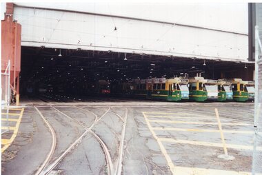 Melbourne Tram Museum
Photograph - Set of 3 Colour Print/s, Colin Rough, 27/01/2002 12:00:00 AM
... Moreland, running in. In the background is the Upfield Railway... Railway line. Photos shows the two signals in the street ...Set of three Colour prints of Brunswick Depot. 27/1/2002 .1 - General view across the yard with Z3 and B class trams (appear to be 2006 and 2098) .2 - View with Z3 129 on the grinder siding and other trams in the background. Has the Depot Allocation Screen showing the location for tram 183. .3 - Looking north along Cameron St, with Z3 183 with the destination Moreland, running in. In the background is the Upfield Railway line. Photos shows the two signals in the street.On rear in ink "Brunswick Depot Melbourne 27/1/02" and (Col's 1st Aussie job) M&MTB 27/1/02"trams, tramways, brunswick depot, z3 class, b class, moreland, cameron st, signals, tram 129, tram 2006, tram 2098, tram 183 -
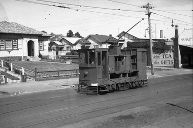 Melbourne Tram Museum
Negative - Set of 2, Wal Jack, 15/03/1945 12:00:00 AM
... the railway line. Possibly a MMTB bus in the foreground... the railway line. Possibly a MMTB bus in the foreground on a Munitions ....1 - Black and white negative, by Wal Jack, of scrubber 5 at the Maribyrnong River terminus. The cross over is in front of the tram. In the background is a shop advertising Robur Tea. .2 - ditto, of the tram descending the Maribyrnong Road shortly after passing over the railway line. Possibly a MMTB bus in the foreground on a Munitions service. Photo dated 15-3-1945 in the Wal Jack album along with details of the location and the tramcar. See Also Reg Item 5469 for another photo.trams, tramways, maribyrnong rd, scrubber tram, work trams, tram 5 -
 City of Moorabbin Historical Society (Operating the Box Cottage Museum)
Photograph, Black & White Postcard, Cheltenham Railway Station c1920, c1920
... Although the Railway line had been planned for some time... the Railway line had been planned for some time Sir Thomas Bent MP ...Although the Railway line had been planned for some time Sir Thomas Bent MP was responsible for making it happen in order to revitalize the fortunes of the Moorabbin Shire that he had represented for so long. The train line opened in 1881with 8 Stations between Caulfield and Mordialloc.The first Steam engine carried dignitaries and local residents. Bent also ensured that the Station houses in his constituency were built in a distinctive decorative cottage style. Bent faced severe criticism for diverting the rail line through his local area and for the expenditure on the Stations. Local residents established and cared for Gardens at the Stations and Cheltenham was awarded Best Garden c1910. The arrival of the Railway Line saw the traders move from Point Nepean Rd to Charman Rd and by 1910 various shops and business were present. 2016 - current has seen large protest rallies against the destruction of Mentone Station and Cheltenham Station as the Victorian State Government proceeds to remove Railway Level Crossings. A compromise to retain the Station buildings whilst placing the Rail Line underground is desired.Cheltenham Railway Station is one of the original cottage style stations ordered by Sir Thomas Bent when the rail line was extended from Caulfield to Mordialloc 1881Photograph Black & White Postcard showing the entrance to Cheltenham Railway Station c1920Valentine &Sons Pub Co Ltd Melb railways, cheltenham station, mentone station, south brighton station, railway level crossing removal 2016 -19, smith j l; smith mary ann, stanley helen, smith vic, smith harry redvers, chaff cutter, horse drawn carts, toll gates brighton, motor cars 1900, steam engines, early settlers, bentleigh, parish of moorabbin, city of moorabbin, county of bourke, moorabbin roads board, shire of moorabbin, henry dendy's special survey 1841, were j.b.; bent thomas, o'shannassy john, king richard, charman s, highett william, ormond francis, maynard dennis, market gardeners, vineyards, orchards -
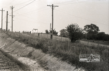
 Buninyong & District Historical Society
Photograph - B/W photograph, Mr C J Brooks, Buninyong Railway Station platform, (built 1889), 9 April 1994
... Remains of Buninyong Railway Station platform, line closed... of Buninyong Railway Station platform, line closed 1947 Only remains ...Remains of Buninyong Railway Station platform, line closed 1947Only remains of Railway stationB/W photo remains Buninyong Railway Station platform, (built 1889) sign on left, power pole and Tennis Club shed, elm tree behind right.buninyong, bunny, railway, platform -
 Buninyong & District Historical Society
Photograph - B/W photograph, Mr C J Brooks, Buninyong Railway Station platform, (built 1889), 9 April 1994
... Remains of Buninyong Railway Station platform, line closed... of Buninyong Railway Station platform, line closed 1947 Only remains ...Remains of Buninyong Railway Station platform, line closed 1947Only remains of Railway stationB/W photo remains Buninyong Railway Station platform, (built 1889) Looking towards Forest Street down former railway track, platform on right, tennis club building, elm tree, tennis court fence on leftbuninyong, bunny, railway, platform -
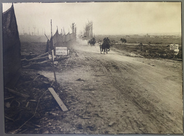 Magnet Galleries Melbourne Inc
hellfire corner, hellfire corner.tif
... -Zillebeke road and the Ypres-Roulers railway line crossed the road...-Zillebeke road and the Ypres-Roulers railway line crossed the road ...Hellfire Corner was a junction in the Ypres Salient in the First World War. The main supplies for the British Army in this sector passed along the road from Ypres to Menin - the famous Menin Road. A section of the road was where the Sint-Jan-Zillebeke road and the Ypres-Roulers railway line crossed the road. The German Army positions overlooked this spot and their guns were registered upon it so that movement through this junction was perilous, making it the most dangerous place in the sector.hellfire corner, ypres salient, war, road, ww1, world war 1 -
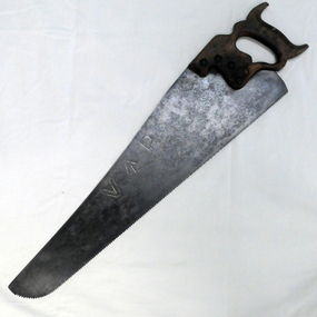 Orbost & District Historical Society
handsaw, C mid 20th century
... 1916 as the terminus of the Orbost railway line, and closed... 1916 as the terminus of the Orbost railway line, and closed ...The Bairnsdale-Orbost railway was opened in 1916 to serve the agricultural and timber industry. Because of the decline in traffic and heavy operating costs, the line was finally closed in August, 1987. Orbost Railway Station was opened on Monday 10 April 1916 as the terminus of the Orbost railway line, and closed in 1987. The station was located on the west side of the Snowy River despite the town of Orbost being on the east side of the river, in order to save on the costs of a bridge over the river, which at the time had highly variable levels. This item is associated with the history of the Orbost-Bairnsdale railway line and therefore reflects the role that the rail line played in the social and economic history of Orbost.A handsaw with a wooden handle and a metal blade with serrated teeth which continue around the nose of the blade.Marked V an upward pointing arrow Rsaw carpentry orbost-bairnsdale-railway orbost-railway-station -
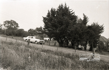
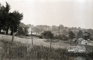
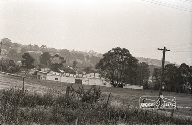
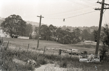
 Eltham District Historical Society Inc
Photograph, Sherbourne Road, Para Road and Simms Road at Briar Hill, 3 November 1967, 3 Nov 1967
... Viewed from railway line opposite Graham Body Works. Simms... melbourne Viewed from railway line opposite Graham Body Works ...Viewed from railway line opposite Graham Body Works. Simms Road is running to the right in front of the old house. The house belongs to Mrs Cameron whose daughter married a DAVEY after which Davey Street is named. Excavation work is being undertaken for the realignment of the Para Road and Sherbourne Road intersection where the current roundabout is located, approximately where the two cars are parked. Mrs Cameron's house and the other are where Montmorency Secondary College is situated. The school opened in 1969.Roll of 35mm black and white negative film, 6 strips Ilford HP3briar hill, cameron, davey, davey road, graham body works, greensborough, montmorency secondary college, sherbourne road, simms road -
 Eltham District Historical Society Inc
Photograph, Sherbourne Road, Para Road and Simms Road at Briar Hill, 3 November 1967, 3 Nov 1967
... Viewed from railway line opposite Graham Body Works. Simms... melbourne Viewed from railway line opposite Graham Body Works ...Viewed from railway line opposite Graham Body Works. Simms Road is running to the right in front of the old house. The house belongs to Mrs Cameron whose daughter married a DAVEY after which Davey Street is named. Excavation work is being undertaken for the realignment of the Para Road and Sherbourne Road intersection where the current roundabout is located, approximately where the two cars are parked. Mrs Cameron's house and the other are where Montmorency Secondary College is situated. The school opened in 1969.Photostitch from multiple images on roll of film. Roll of 35mm black and white negative film, 6 strips Ilford HP3briar hill, cameron, davey, davey road, graham body works, greensborough, montmorency secondary college, sherbourne road, simms road -
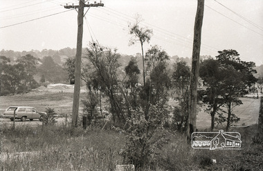
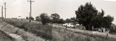
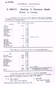 Otway Districts Historical Society
Timetable, Victorian Railways, Amendment to Opening of Extension, Beech Forest to Crowes, 16 June 1911
... of the railway line from Beech Forest to Crowes in June, 1911, is amended... the extension of the railway line from Beech Forest to Crowes in June ...The circular, S.2628/11, opening the extension of the railway line from Beech Forest to Crowes in June, 1911, is amended by S.2779/11 of 1911. The DOWN train runs from Colac to Beech Forest on Mondays, Tuesdays, Thursdays and Saturdays, departing at 3.00pm and arriving at 6.45pm. The UP train departs Crowes daily at 12.45pm arriving at Beech Forest at 2.15pm, and Colac at 6.26pm, stopping where necessary at Tulloh and Ditchley to pick up or set down passengers.B/W, photograph. Originally dated 16 June 1911, S. 2628/11, Opening of Extension, Beech Forest to Crowes, is amended by a further circular, S.2779/11. The DOWN train leaves Colac on Monday, Tuesday, Thursday and Saturday; the UP train leaves Crowes daily.colac; beech forest; crowes; timetable; railways;