Showing 1101 items
matching information map
-
 Glen Eira City Council History and Heritage Collection
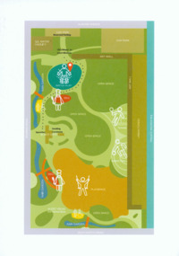
Event Run-sheet and Map, "Booran Reserve Official Opening"
This run-sheet and map were used for the opening of Booran Reserve at the corner of Booran and Glenhuntly Roads on Tuesday 11 April 2017. The Reserve was officially opened by the Mayor, Cr. Mary Delahunty and The Hon. Philip Dalidakis, MP, Minister for Innovation. The run-sheet contains information about the Order of Proceedings of the opening ceremony. The map notes the locations of reserved parking, the route taken by Mayor Mary Delahunty and Minister Philip Dalidakis through the Reserve, and the speech and smoking ceremony site. The site of the Reserve was previously the Caulfield Service Reservoir.Black and white printed run-sheet, and green, teal, red, yellow, blue and khaki colour printed map -
 Clunes Museum
Flyer - BROCHURE
Current information for tourists visiting ClunesColour brochure of Clunes Museum with map of Clunes on the reverseClunes Museum - Built on Goldmap of clunes, tourism brochure, clunes museum -
 Beechworth Honey Archive
"Wooden" Diary by Frank Lebbell Frost
This is the diary of Frank L. Frost; a beekeeper who worked in North-East Victoria. It covers from 1915 to 1924.This diary is very significant as it gives details about the methods used by early beekeepers in Australia. As it also contains information such as location and condition of flowering plants preferred by bees in specific locations, this diary is very significant because it can be used to see how those locations have changed over the years.Hand-written diary containing notes, maps, drawings, charts, tables, some newspaper cuttings and financial information. It contains approximately 72 pages. The original diary was encased in wooden frames.hand written, hand-written, diary, beekeeper, record, frost, beechworth honey -
Surrey Hills Historical Society Collection
Folder of information, Libby Cavenagh's 1990 building census of Wandsworth Road, Surrey Hills, 1990
Libby Cavenagh was Secretary of the Surrey Hills Historical Society. She completed this study as part of a Diploma of Local History she was undertaking at the University of New England. At the time she lived in Wandsworth Road.This is a unique analysis of the housing stock of a complete street at one point in time. Many of the houses have been altered since the study was completed and quite a number have been demolished.Blue folder of A4 size. This contains an analysis of each house in Wandsworth Road in 1990 with details regarding building style, approximate age, materials used, fence design, presence or absence of a garage or carport and some comment on the garden elements. For most entries there is a coloured photo taken from the street. For some there are photocopies of real estate advertisements. There are a number of appendices including s a map of the breakdown of styles and materials; date of construction and other information from the Camberwell Building registers 1890-1934; entries re owners from Sands & McDougall directories, 1897-1937; map from Land Titles Office showing sub-division information; land auction advertisements; information re W J Vine; list of builders; references.wandsworth road, libby cavenagh -
 Federation University Art Collection
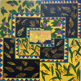
Painting - Artwork, [Untitled]
Under the direction of lecturer Raymond Thomas five students of Koorie Studies at the Gippsland Centre for Art and Design created this work. The were Vickie Turvey, Robyn Yates, Kellie Parsons, Melissa Fenton, Deanna Mobourne.A large canvas with indigenous plants, and Aboriginal animal motifs. If you can assist with information about this artwork, or the artist, please use the comment box below. artwork, artist, gippsland campus, aboriginal, kangaroo, emu, fish, clan map, vickie turvey, robyn yates, kellie parsons, melissa fenton, deanna mobourne, koorie studies -
Vision Australia
Text, The Association for the Blind, Blind Members' Council meeting minutes 25/3/1991 to 7/2/1994, 1991-1994
These meetings were held at the Kooyong office and the minutes include Present, Chair, Apologies, Minutes, Matter arising from minutes, Correspondence, Life governors, Election of members, Nominations, Reports from Regional Blind Members groups. Some highlights include: 27/7/1992 Mr Ian Moore reported where possible a volunteer driver will be provided to transport members to and from day centres. Where a volunteer driver is not available a taxi will be arranged at the member's expense, with financial hardship cases assisted. 4/3/26/4/1993 a tactile map of AFB Centres has been produced with the assistance of Mr. Danby for members' information. 31/5/1993 it was reported a donation by Mr John Wicking of $50,000 was received to enable the History of the Association to be written by Mr John Wilson. 1 bookassociation for the blind -
 Port Fairy Historical Society Museum and Archives
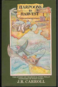
Book, Warrnambool Institute Press, Harpoons to harvest : the story of Charles and John Mills, pioneers of Port Fairy / J.R. Carroll, 1989
The story of Charles and John Mills, pioneers of Port Fairy. Includes genealogical information.xv, 286 p., [12] p. of plates : ill., geneal. tables, maps, ports. Includes index. Geneal. tables on lining papers. Bibliography: p. 225-260non-fictionThe story of Charles and John Mills, pioneers of Port Fairy. Includes genealogical information. maritime, mills, john brabyn, 1810-1877, charles frederick, 1812-1855, mills family, pioneers -- victoria -- port fairy -- biography, pioneers -- tasmania -- biography, australian history, biography, exploration, genealogy, harbour master, mills : charles and john, mills brothers, port fairy, shipping, warrnambool history, whaling, wrecks, book -
Vision Australia
Administrative record (Series), National Information Library Service annual reports, 2002-2004
NILS, 454 Glenferrie Road, Kooyong, Victoria, 3144To provide information on general information on work undertaken, financial position, income and cash flow.Single volumes created annually from 2002 until 2004.Chairman's message, CEO message, Finance Report, General Overview of Services.corporation records, national information library servicecorporation records, national information library service -
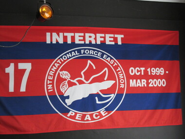 Lilydale RSL Sub Branch
Flag, Panhandling Australia Pty Ltd, Interfet
Red and blue horizontal stripes. The words Interfet - ttop centre. No 17 LHS October 1999 - March 2000 RHS. Historical information - Double circle, in centre is a map of East Timor with floral emblem, surrounded by the words 'International Force East Timor, Peace at base of circle. -
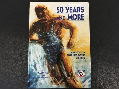 Port Fairy Historical Society Museum and Archives
Book, Alan Best and Contributors, 50 Years and More / A History of Surf Life Saving Victoria
History of Surf Life Saving Victoria over 50 years154p. :I;;. (Some col.), maps. Ports., fascism,:non-fictionHistory of Surf Life Saving Victoria over 50 yearssurf life saving victoria, surf lifesaving (aquatic sports), history, book -
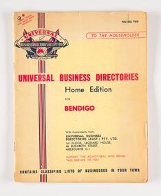 City of Greater Bendigo - Civic Collection
Book, Universal Business Directories, Universal Business Directory for Bendigo, c 1950
Business Directories such as this were common right up until the widespread use of the internet and search engines such as Google to find information. Universal Business Directories were a company which sought advertisers from local areas to offset the cost of producing the directories. This directory includes a history of Bendigo, map and recipes as well as extensive listings for local business, trades and services. 50 page, three colour commercially printed business directory designed to by hung beside the telephone. Includes advertising and listings for a wide variety of local businesses. Includes a page of recipes and information for emergency services. city of bendigo, city of bendigo commerce -
 City of Greater Bendigo - Civic Collection
Booklet, Cambridge Press, City of Bendigo Handbook 1978, 1978
Handbook for residents with information about rates, garbage collection, numbering houses, building, dog registration etc.Black and white printed, seven page handbook for residents. Centre page illustrated map. Front cover; photo of Sacred Heart Cathedral. Handbook is folded in centre. Stapled on fold. councillor r turner, mayor turner, city of bendigo -
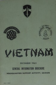 Diamond Valley Vietnam Veterans Sub-Branch
Booklet - n/a, General Information Guide, Vietnam, December 1963, 22/3/2009
Booklet detailed general information for US Forces in Vietnam and, often this information was imparted onto Australian Forces.Some elements of the General Information form the conditions under which Australian Forces lived and served whilst in Vietnam.Green light cardboard cover with black text and logos on front cover; a map showing Saigon and surrounds on back cover.Three logos: Military Assistance Command, Vietnam; MAAG-Vietnam; U.S. Navy, Headquarters Support Activity, Saigonvietnam, vietnam war, diamond valley vietnam veterans sub branch, us forces -
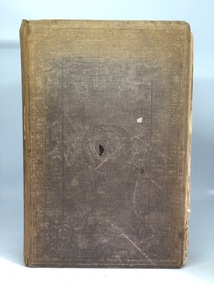 Kilmore Historical Society
CHAMBERS INFORMATION FOR THE PEOPLE VOL 2, 1848
... , History - Geography' 809 pages ; Maps; Illus; Chambers Information ...Faded brown loose cloth cover with embossed detailing on cover and spine 'Chambers information for the people, Vol 2, History - Geography' 809 pages ; Maps; Illus; Handwritten inscription on first page - '37, 41, 040 CHA R 29' Stamp on various pages 'Kilmore Mechanics Institute' encyclopedia, kilmore mechanics institute library. -
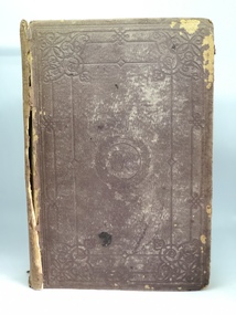 Kilmore Historical Society
CHAMBERS INFORMATION FOR THE PEOPLE VOL 1, 1848
... on cover and spine 'Chambers information for the People, Vol 1 ...Faded brown loose cloth cover with embossed detailing on cover and spine 'Chambers information for the People, Vol 1 Sciences - Arts & C.' 809 pages ; Maps; Illus; 27cm Handwritten inscription on first page - '36, 41, 040 CHA R 28' Stamp on various pages 'Kilmore Mechanics Institute' science, arts, kilmore mechanics institute library. -
Tarnagulla History Archive
Folder - Waanyarra / Jones Creek, 1990s
Red binder containing information on Waanyarra & Jones Creek. Posters/flyers for 'Back To' reunions, map and names list for cemetery. Compiled by Donald Clark. -
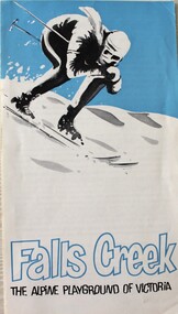 Falls Creek Historical Society
Booklet - Falls Creek THE ALPINE PLAYGROUND OF VICTORIA
This publication was released by the Falls Creek Tourist Area Management Committee during the 1969 snow season. It followed decisions to expand the accommodation and services to approximately double its size at that time. It was aimed at promoting the Resort in an effort to attract further interest and potential investment in this development.This brochure is significant because it documents the manner in which the Tourist Resort was prompted for investors.A fold out brochure with a skier on the front cover. The leaflet information about the size and location of Falls Creek including names of several lodges and a map of the Tourist Village on the back cover.Front cover: Falls Creek THE ALPINE PLAYGROUND OF VICTORIAfalls creek tourist resort, falls creek development, falls creek promotion -
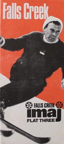 Falls Creek Historical Society
Booklet - imaj FLAT THREE Falls Creek
This brochure was published for the 1973 winter season. IMAJ Flat 3 is part of the IMAJ apartment complex in Falls Creek, Victoria. This brochure includes information about the Falls Creek area as well as a description of the accommodation and facilities in Flat 3. An insert includes a list of tariffs for Winter '73 and an inventory of items included at this accommodation.This Brochure is important because it documents a variety of accommodation in Falls Creek.An orange, black and white brochure advertising imaj Flat Three in Falls Creek. It has an image of a downhill skier on the front. When folded out, the brochure contains detailed information about facilities provided. An image of skiers and a map of Falls Creek is on the back.At top on front: Falls Creek Below skier: FALLS CREEK imaj FLAT THREEaccommodation falls creek, imaj apartments -
Friends of Ballarat Botanical Gardens History Group
Work on paper - Wellingtonia, Autumn 2014, Tree of the Month, Autumn, 2014
This page gives historical information of Gondwana found in the Ballarat Botanical Gardens.These families of plants are confined originally to Australasia and South America and at least 15 are to be found in the Ballarat Botanical Gardensp.4 of the Friends of Ballarat Botanical Gardens periodical, The Wellingtonia. This is a printed page with 2 maps of the Globe, right-hand side of the page.None.john garner, doctor, doctor john garner, tree of the month, gondwana trees in the ballarat botanical gardens, friends of ballarat botanical gardens, history group, conifers, bunya bunya pine, monkey puzzle, wellingtonia, araucaria, john garner collection, gardens, ballarat -
Beechworth Cemetery Trust
Map - Beechworth Cemetery reproduction of original map -Secretary copy, Beechworth Cemetery
... with additional information hand-written on the map. ... with additional information hand-written on the map. Beechworth Cemetery ...Reproduction map displaying all grave sites in Beechworth Public Cemetery. Rotunda, fountain, nursery, memorial wall, pioneer sectionmap displays the plan of grave sitesLaminated Photocopy of original cemetery map with additional information hand-written on the map. All graves at the cemetery set out in denominational sections with hand-written information on additional graves added to sections in Roman Catholic A & C, Church of England A-F, Presbyterian A-C, Methodist/Uniting B and Wesleyan A. Multidenominational hand-written note on Jews section with Trust Minutes 4.7.'83 written next to this addition. Additions hand-drawn of fountain, memorial wall, nursery and pioneer cemetery.rotunda, fountain, nursery, memorial wall, pioneer section, graves, chinese section, un-numbered grave sites, cemetery -
Beechworth Cemetery Trust
Map - Beechworth Cemetery reproduction of original map, Beechworth Cemetery Reproduction - Treasurer copy
... with additional information hand-written on the map. ... with additional information hand-written on the map. Beechworth Cemetery ...Reproduction map displaying all grave sites in Beechworth Public Cemetery. Rotunda, fountain, nursery, memorial wall, pioneer sectionmap displays the plan of grave sitesLaminated Photocopy of original cemetery map with additional information hand-written on the map. All graves at the cemetery set out in denominational sections with hand-written information on additional graves added to sections in Roman Catholic A & C, Church of England A-F, Presbyterian A-C, Methodist/Uniting B and Wesleyan A. Multidenominational hand-written note on Jews section with Trust Minutes 4.7.'83 written next to this addition. Additions hand-drawn of fountain, memorial wall, nursery and pioneer cemetery.rotunda, fountain, nursery, memorial wall, pioneer section, graves, chinese section, un-numbered grave sites, cemetery -
Beechworth Cemetery Trust
Map - Beechworth Cemetery reproduction of original map - On site in Rotunda, Beechworth Cemetery
... with additional information hand-written on the map. ... with additional information hand-written on the map. Beechworth Cemetery ...Reproduction map displaying all grave sites in Beechworth Public Cemetery. Rotunda, fountain, nursery, memorial wall, pioneer sectionmap displays the plan of grave sitesLaminated Photocopy of original cemetery map with additional information hand-written on the map. All graves at the cemetery set out in denominational sections with hand-written information on additional graves added to sections in Roman Catholic A & C, Church of England A-F, Presbyterian A-C, Methodist/Uniting B and Wesleyan A. Multidenominational hand-written note on Jews section with Trust Minutes 4.7.'83 written next to this addition. Additions hand-drawn of fountain, memorial wall, nursery and pioneer cemetery.rotunda, fountain, nursery, memorial wall, pioneer section, graves, chinese section, un-numbered grave sites, cemetery -
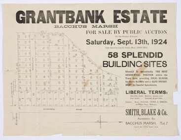 Bacchus Marsh & District Historical Society
Map - Land Sales Plan, Grantbank Estate Bacchus Marsh, 1924
The Grantbank Estate was a parcel of land close to the centre of the shopping area of Bacchus Marsh which was sub-divided and offered for sale in 58 lots on the 13th September, 1924. It comprised an area of 15 acres, being a portion of the Millbank Estate which had been in the hands of the Grant family for 75 years. The lots had frontages to Gisborne Road, Patterson, William and Sutherland Streets. This was a significant sub-division of land and represented a major expansion of residential housing in Bacchus Marsh in the early 20th century.This land sale map is a typical example of housing estate land sales advertising maps produced by real estate agents in this era. The map is significant for the detailed information it provides about when and where land was sold for new housing estates in Bacchus Marsh in the early twentieth century.Printed paper mapland sales bacchus marsh, land subdivsion bacchus marsh, housing estates land sales bacchus marsh, grant family bacchus marsh -
 Bacchus Marsh & District Historical Society
Map, Bacchus Marsh Township and Nearby Districts Maps Volume
This volume of maps is believed to have been compiled by staff at the Shire of Bacchus Marsh and was presumably used to inform and assist Shire staff and Councillors in the carriage of their duties.This collection of maps are significant due to their rarity as many of them are unique maps made for local purposes in the Bacchus Marsh region. They are also of strong research value containing a wide variety of information including landholders, land sales, infrastructure, such as roads, bridges, public, commercial and private buildings, houses, land use, and geographic features over multiple decades from the late nineteen century into the middle part of the twentieth century.One bound volume of maps comprising cadastral maps, (indicating property owners and land boundaries), land plans and real estate auction plans and advertising material, and other maps indicating major infrastructure like proposed roads and irrigation areas. Most of the maps and plans are of Bacchus Marsh and nearby areas but some maps are of nearby towns such as Melton, Ballan and Blackwood. The volume comprises 52 pages. Most pages have a single map or plan pasted onto it but some contain 2 or 3 different maps. There are 81 maps in total. Map 1 Liquidators Sale 1896. Map 2. Woodside Estate Sale 1913. maps, maps bacchus marsh, maps bacchus marsh region -
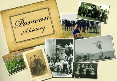 Bacchus Marsh & District Historical Society
Book, Parwan: A History, 2010
Explores the history of the small farming community on the outskirts of Bacchus Marsh. It contains a plethora of fascinating details about the early years of this farming community from the 1830s until the early 2000s. There is a brief section at the beginning which looks at the history of the area prior to the colonial era. The book contains numerous sections about families and individual people who have lived in the Parwan area and includes many images of places and people. Citation: Parwan: A History by Dianne Van Leuvan. Published by Parwan History Group, Bacchus Marsh, Vic., 2010.Paperback printed book. 128 pages. with illustrations and photographs, some coloured. Includes facsimiles, maps, and index. Includes a separate folded sheet inside a pocket which has a reproduction of a map of the Parwan Parish in the County of Grant. On the reverse of this sheet are two reproductions. One is a land auction plan for February 1910 advertising the sale of portions of land from the Nerowie Estate. The other reproduction is a section of a map showing some of the blocks of land in the Nerowie Estate which has the heading, 'Nerowie Titles 1898'. A pocket inside the back cover contains a separate booklet which is an index, and two pages of 'Additional Information'.non-fictionExplores the history of the small farming community on the outskirts of Bacchus Marsh. It contains a plethora of fascinating details about the early years of this farming community from the 1830s until the early 2000s. There is a brief section at the beginning which looks at the history of the area prior to the colonial era. The book contains numerous sections about families and individual people who have lived in the Parwan area and includes many images of places and people. Citation: Parwan: A History by Dianne Van Leuvan. Published by Parwan History Group, Bacchus Marsh, Vic., 2010.parwan vic. history -
 Mont De Lancey
Book, A. H. Massina & Co, A.H. Massina and Co's Weather Almanac and General Guide and Handbook for Victoria for 1894, 1901
A plain red hardcover book - Weather Almanac and General Guide and Handbook for Victoria 1894. A.H.M. & Co's Almanac 1894 - 01. There are maps, calendars, diagrams and general information throughout the book for the guidance of village settlers.A red hardcover Weather Almanac and general Guide and Handbook for Victoria for 1894 - 01 with Calendar and Map of Railway Systems. It has advertisements, tables, calendars, maps, memoranda tables, diagrams and other notes of general interest throughout. non-fictionA plain red hardcover book - Weather Almanac and General Guide and Handbook for Victoria 1894. A.H.M. & Co's Almanac 1894 - 01. There are maps, calendars, diagrams and general information throughout the book for the guidance of village settlers.almanacs, documents, calendars -
Tarnagulla History Archive
Prospectus: Reef Mining NL - Tarnagulla Gold Project, Reef Mining NL - Tarnagulla Gold Project, circa 1995
Donald Clark Collection. A cardboard folder with colour image of poppethead on cover and title 'Prospectus: Reef Mining NL - Tarnagulla Gold Project'. Contained inside are maps and mining reports and other information about the Tarnagulla Gold Project.tarnagulla, gold, mining, reef mining nl -
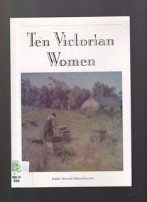 The Celtic Club
Book, Bronwyn Fensham, Ten Victorian women, 1999
This book summarises various sources available in the PROV used to build a picture of the lives of ten women whose records are available. it highlights the information that can be found.Plates, ill, map, p.51.non-fictionThis book summarises various sources available in the PROV used to build a picture of the lives of ten women whose records are available. it highlights the information that can be found.women - victoria - history - sources, women pioneers - victoria - history -
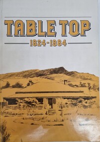 Wodonga & District Historical Society Inc
Book - Table Top 1824 - 1984, Merrick L Webb
This publication was compiled for the Centenary celebrations of the Table Top school in 1984. Known by the Aborigines as Mullyan-argina, or breeding place of eagles, the flat topped hill attracted the attention of Hume and Hovell's expedition in November 1824 and Hamilton Hume named Battery Mount. Later on, when the Mitchell family acquired the run they named it Table Top. The book contains detailed information about the district and pioneer families who contributed to its development.A paperback publication of 80 pages including photographs and maps compiled by the Table Top History Committee.This publication was compiled for the Centenary celebrations of the Table Top school in 1984. Known by the Aborigines as Mullyan-argina, or breeding place of eagles, the flat topped hill attracted the attention of Hume and Hovell's expedition in November 1824 and Hamilton Hume named Battery Mount. Later on, when the Mitchell family acquired the run they named it Table Top. The book contains detailed information about the district and pioneer families who contributed to its development.table top nsw, hume & hovell, the mitchell family, table top pioneers -
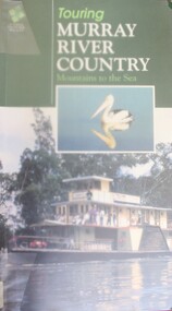 Wodonga & District Historical Society Inc
Book - Touring Murray River Country, Stone, Derrick I & Stone, Sascha C, 1996
A touring guide of the Murray RIver, Australia from its source in the mountains following its journey to the sea. The first sections cover information about the area of the Upper Murray, including Lake Hume and the Albury-Wodonga area.A publication of 128 pages includes 230 full colour photos, 42 illustrations and 19 colour route maps. A touring guide of the Murray RIver, Australia from its source in the mountains following its journey to the sea. The first sections cover information about the area of the Upper Murray, including Lake Hume and the Albury-Wodonga area.murray river, australia - tourism