Showing 14766 items
matching north road
-
 Port Melbourne Historical & Preservation Society
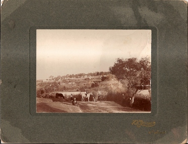
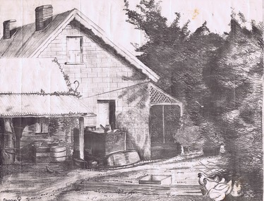
Photograph - Woolsheds between Beacon and Barak Roads, Port Melbourne, Don Hossack, 1947
... sheds between Beacon and Barak Roads. Shows north easternmost... sheds between Beacon and Barak Roads. Shows north easternmost ...Donated by Don Hossack who took the photograph when he was 16 years old and working at the woolsheds. He recalls that bags of oats and barley were stored here.Photo (10 x 12" glossy black and white print) of the wool sheds between Beacon and Barak Roads. Shows north easternmost sheds and rail line. The wool sheds were built by the Americans during World War II and taken down again in the 1950s . Map (hand drawn) on rear shows location of photograph.map (hand drawn) of location of photographtransport - railways, built environment - industrial, war - world war ii -
 Melbourne Tram Museum
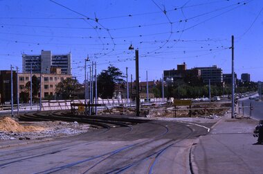
Slide - Set of 2, Keith Kings, 24/12/1967 12:00:00 AM
... Kings of 24/12/1967 - .1 - St Kilda Junction, looking north... north along St Kilda Road, showing the nature of the diversion ...Set of two 35mm Kodak white cardboard colour slide by Keith Kings of 24/12/1967 - .1 - St Kilda Junction, looking north along St Kilda Road, showing the nature of the diversion from the junction for Wellington St. .2 - Dandenong Road, showing the track diversion work for Dandenong Road/Queensway, Windsor.Keith Kings stamp and number "15-1" and "15-5"", with details of exposure. .1 - SW6 car on temporary track at St Kilda Junction looking north from turnout during freeway work .2 - Dandenong Road west from Hornsby St with section of straight track ready to replace curves onto new b.v.w. track to Chapel St - 907 coming off soon to be abandoned street track.trams, tramways, st kilda junction, trackwork, road works, dandenong road, queensway, tram 907 -
 Ringwood and District Historical Society
Map - Public Land Sale by Thomas Ham, 2000 Acres for Sale - Crown Sections 20, 23, 24 - Ringwood, Victoria - 1855
... , with southern boundary of allotments later forming part of Oban Road... Road Ringwood North melbourne TRANSCRIPT: "This really valuable ...Two 1850s surveyor's maps on cardboard backing showing area from Melbourne extending East beyond Bulleen and Nunawading. Detailed description of lots for sale and navigational directions to the property from Richmond by Thomas Ham, Victorian public servant, map maker, publisher, lithographer and original Ringwood land owner. Inset map enlarging area between Yarra River and Dandenong Creek, with southern boundary of allotments later forming part of Oban Road, North Ringwood.TRANSCRIPT: "This really valuable Property is now offered to the public for sale, in lots to suit purchasers at the Iow rate of £1 per Acre for 80 acres and upwards, and £1.10s per Acre for any smaller portion. Terms of payment Half Cash, Balance in 6 and 12 months, bearing 8 per cent interest. The Estate is well wooded with Gum, Cherry Tree and Stringy Bark, with Wattle in the valleys of the several creeks. Every lot is Staked and Trenched at the corners marked on the Plan thus - The Surveyor has carefully sub-divided the Property, in order to give every Farm a Creek for Water, Valley for Cultivation, and Hills for House and Grass Paddock. The ROADS have been very carefully laid out so as to give a firm, well drained, and nearly level road to each Homestead. Intending purchasers can readily find the property by the following directions, viz: Start from Richmond Bridge, at Hawthorne, then take the left-hand road to KEW. When at the "Woodman Inn", take the Cotham Road to the right, bearing due east, keep this Road, passing Trainor's "White Horse" Inn, and before you leave the fences, you will see calico bills (see margin) nailed to the Trees on the bush track leading to the Upper Yarra country, follow the Bills till you come to the SOUTH boundary line of the Property, which bears East and West (see Plan) where you will see Bills nailed up "THIS PROPERTY FOR SALE, etc." The Bills from Town lead direct to where Mr. Jull is erecting his Store, and arrangements have been made with him to show the lots to intending purchasers free of charge. At the respective corners of the lots the Bills are nailed up double, with numbers to denote the lot, and that the corner stake is adjacent. Any parties wishing to proceed to the property by way of BULLEEN will find Bills nailed on the Trees, commencing at the NEW INN, at "Wilson's Slip Rail." Keep this Track till you come to the Log Bridge, over the Deep Creek at Bloxhome's Paddock; go through the land now being cleared; keep the track over the hill till you come to an Iron House, you will then be on the property, which Iies to the North and East as per Plan. Follow the Bills till you come to Mr. Jull's Store, etc. etc. Further particulars can be had from the Agent for the Property. THOMAS HAM. " -
 Glen Eira Historical Society
Photograph - Balaclava Road, 345, Caulfield North
... Balaclava Road, 345, Caulfield North... of Balaclava and Kambrook Road, Caulfield North. The earlier photograph...345 Balaclava Road, Caulfield North, Victoria, Australia...-east corner of Balaclava and Kambrook Road, Caulfield North ...Two photographs of buildings on the south-east corner of Balaclava and Kambrook Road, Caulfield North. The earlier photograph (250mm x 200mm) is printed in black and white and is undated. The later photograph (130mm x 90mm) is colour, unattributed and is dated 11/1980. In 2012 this building has two addresses Balaclava Road, 345 and Kambrook Road 22.balaclava road, kambrook road, caulfield north, streetscapes -
 Ballarat Tramway Museum
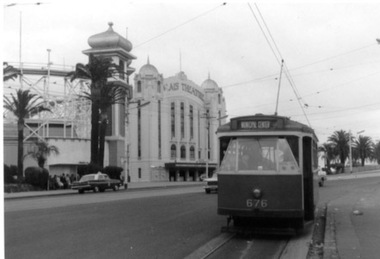
Photograph - Black & White Photograph/s, 31/10/1965 12:00:00 AM
... - Hawthorn Road, just north of Balaclava road, looking south. SW6... destination of "Municipal Center" 1422.2 - Hawthorn Road, just north ...Set of three Black and white photographs on Kodak paper of an Association of Railway Enthusiasts tram tour with X2 676. The tour featured the use of a Washington DC destination roll. Date of Tour 31/10/1965. 1422.1 - X2 at the terminus of route 69/79 routes at the Esplanade, St Kilda. Note the track is alongside the north side kerb. Has Palais Theatre in the background and Luna Park. Tram showing destination of "Municipal Center" 1422.2 - Hawthorn Road, just north of Balaclava road, looking south. SW6 869 alongside. 676 on temporary track - during the reconstruction of Hawthorn Road - permanent track has been completed alongside. Tram showing destination of "Racecourse" 1422.3 - X2 676 on "Bang Road" Coldblo Road at Malvern depot entry looking east. Tram showing destination of "Friendship Hts". See P.Winspur notes, data sheet for Reg. Item 1418 and Dave Macartneytrams, tramways, tram tours, are, trackwork, mmtb, tram 676, tram 869 -
 Greensborough Historical Society
Photograph - Digital image, Outhouse, Willis Vale, 1920c
... in 1964 when a fire originating from North Plenty Gorge - Kurrak...Greensborough Historical Society 34A Glenauburn Road Lower ...This photograph shows one of the out buildings at 'Willis Vale', a property owned and farmed by the Partington family from the 1870s. The derelict Willis Vale house was destroyed in 1964 when a fire originating from North Plenty Gorge - Kurrak Road - was lit by two teenage boys and made its way several kilometres down to Partington's Flat Greensborough.The hoe of a pioneer Greensborough family.Digital copy of black and white photograph.willis vale, partington family -
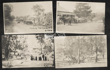 Eltham District Historical Society Inc
Photograph, Tom Prior, Group of scenes from the Eltham District, c.1905
... , Research, c.1907 SEPP_0612: Eltham, Main Road. Looking north from..., Research, c.1907 SEPP_0612: Eltham, Main Road. Looking north from ...Photo shows four images from the Shire of Eltham Pioneers Photograph Collection: SEPP_0501: West's Research Hotel, Main Road, Research, c.1907 SEPP_0612: Eltham, Main Road. Looking north from corner of Dudley Street, c.1904 SEPP_0616: Forming the footpath, Eltham, c.1906 SEPP_1000: Main Road, Hurstbridge, c.1905 Black and white/sepia photograph of four individual photographsbakery, eltham, eltham village reserve, footpath, gahan house, general store, haley's paddock, hurstbridge, luther haley, luther haley general store, main road, old mac (horse), picnic, pioneers and painters, punch (horse), railway store, research (vic.), research hotel, reynolds prior collection, richard reynolds, road construction, sepp, shire of eltham pioneers photograph collection, summer drinks, tilley lamp, york street -
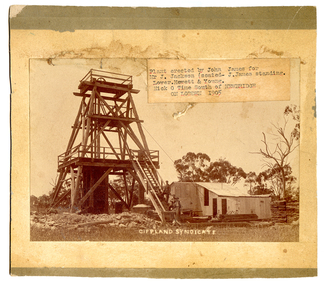 Tarnagulla History Archive
South Gippsland Syndicate mine, Nick o' Time Lead, 1905, 1905
... -Eddington Road, approximately one kilometer north of the Poseidon... kilometer north of the Poseidon Road intersection. The remains ...John James is standing on the staircase. He erected the poppet head and buildings on behalf of the syndicate. He was an experienced mine manager and highly regarded local engineer. The mine was located close to and on the western side of the Newbridge-Eddington Road, approximately one kilometer north of the Poseidon Road intersection. The remains of a once-prominent mullock head can be seen on the site. Paper label stuck onto image reads 'Plant erected by John James for Mr J. Jackson (seated - J. James, standing). Lower Hewett & Young. Nick O Time South of Newbridge ON LODDON 1905'. -
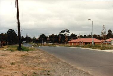 Hume City Civic Collection
Photograph, early 1990s
... . It is a photograph taken at the north end of Anderson Road looking towards.... It is a photograph taken at the north end of Anderson Road looking towards ...The series of 5 photographs feature different views of the Woodlands Housing Development which opened up land bounded by Gap and Anderson Roads, Cornish Street and Elizabeth Drive in the early 1990s. It was a large housing development built close to Sunbury township.A coloured photograph of one of the last housing developments which took place in the old township area. It is a photograph taken at the north end of Anderson Road looking towards Gap Road. One house has been built and there are a number of 'For Sale' signs of blocks fronting Anderson Road. Guttering and driveways have been formed on one side of the road.housing developments, anderson road, george evans collection -
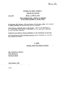 Melbourne Tram Museum
Document - Notice, The Met, "Track Reconstruction - Removal of Crossover in the Upper Esplanade at Acland St", 14/10/1986 12:00:00 AM
... , Kew Cotham Road and North Richmond Services. Signed by B... and the alterations to services for Moreland, Kew Cotham Road and North ...Typed notice on an A4 sheet, titled "Track Reconstruction - Removal of Crossover in the Upper Esplanade at Acland St" advising crews of the work and the alterations to services for Moreland, Kew Cotham Road and North Richmond Services. Signed by B. Moore Regional Operations Manager Southern of the MTA Tram and Bus Division, dated 14/10/1986. Notice D 3953Has in to the top right hand corner in ink "72Drv Sun"trams, tramways, trackwork, mta, st kilda, luna park -
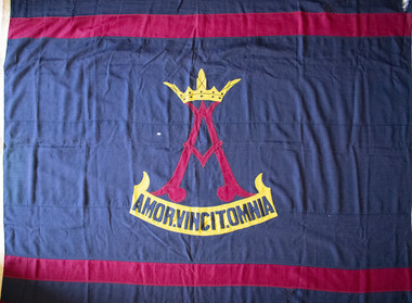 Brighton Historical Society
Flag, W. Morgan & Co, School flag, circa 1910s - 1930s
... at 106 North Road, Brighton. The plan was to open a private... Victorian villa at 106 North Road, Brighton. The plan was to open ...This flag was used by Rosbercon Girls Grammar School, which operated in Brighton from 1906 until 1941. The school was established in 1906 by the Tisdall family. The Tisdalls were a family of educators: Irish-born Henry Thomas Normanton Tisdall and his wife Lucy taught for many years at the Walhalla State School in Gippsland, along with Lucy's sisters Alice and Clara Weekes. Three of the Tisdall daughters, Ethel, Constance and Theodosia (Theo) followed their mother and aunts into the teaching profession. Constance in particular considered education her true calling and harboured a dream of one day being principal of her own school. After Henry's death in 1905, faced with financial uncertainty and several unmarried daughters to support, Lucy Tisdall decided to take a risk. She sold the family's Toorak home and, together with her sister Alice, leased 'Ashburnham', a large Victorian villa at 106 North Road, Brighton. The plan was to open a private school, with Ethel and Constance as co-principals and Lucy, Alice and Theo teaching and managing the household affairs. This came as a "joyful surprise" to Constance, who was only informed of the plan after it had been finalised. The school was named Rosbercon after Henry's home village in County Wexford, Ireland. The crest, designed by son Bert Tisdall around 1910, featured a crowned letter 'A' above the motto "amor vincit omnia" ("love conquers all"), both inspired by a verse in Geoffrey Chaucer's "The Prioress's Tale": "about her arm she bore/A paire of bedes gauded all in grene,/And theron heng a broche of gold full shene,/On which there was first writ a crowned 'A',/And after, Amor Vincit Omnia." It was a motto Constance held close to her heart, embodying her values as a teacher. Reflecting in 1961, she wrote, "In a school without punishments, a school with love and understanding between teacher and pupil - with a love of teaching on one side, and a desire to learn on the other, love would indeed conquer all." The school's opening day in 1906 proved less than auspicious, with no pupils arriving at all. The women persisted and by the end of the first week, five students had been enrolled. From here, the school grew steadily in size. A new schoolroom designed by architect Harold Desbrowe-Annear was built in the house's orchard to accommodate the increasing numbers, but by 1911 the Tisdalls began looking for larger premises. They leased the nearby property 'Hazeldean' at 124 North Road and, during the 1912 school holidays, the Desbrowe-Annear schoolroom was raised onto a lorry drawn by sixteen horses and moved down the road to what would become Rosbercon's new home. In 1923, Constance instituted a modified version of the Dalton Plan, an education model based on individualised learning. Girls in senior years were encouraged to work more independently, making regular use of the reference library and working to a monthly assignment schedule. The school performed well academically and in competitive sport, but over time was eclipsed by the nearby Firbank Church of England Girls' Grammar School (established 1909), whose institutional backing provided it with access to wider resources and facilities than those of the small family-run Rosbercon. At the end of 1933, Ethel and Theo retired and Constance became principal of St Anne's Church of England Girls' Grammar School (now Gippsland Grammar) in Sale. Rosbercon was sold to Miss Iris Hay, who served as principal from 1934 until the school's closure in 1941. Following her own retirement in 1947, Constance Tisdall settled in Erica Avenue, East Malvern, in a house named 'Rosbercon' after her former school. She continued teaching English literature, mostly to migrants, and enjoyed regular visits from former students. Well into the late 1960s, old Rosbercon girls continued a tradition of coming together for an annual reunion on the first Saturday in November, on which day Constance would fly the school flag at her home.Large navy blue flag with horizontal maroon stripe at top and bottom, and school crest in centre. Stylised maroon "A" topped with yellow crown. Yellow scroll below with motto in navy blue letters: "AMOR.VINCIT.OMNIA".flag, school flag, rosbercon girls grammar school -
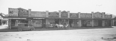 Ringwood and District Historical Society
Photograph, Maroondah Highway Central, Ringwood. Beilby Stores, 1924. (See also MHC0115)
... shows shops on north side of road including Beilby Stores... shows shops on north side of road including Beilby Stores ...Black and white photograph. Typed below photograph: "1924 Whitehorse Road shops. Entrance to Ringwood Hall on left. Post Office on right.". Image shows shops on north side of road including Beilby Stores and McAlpin's estate agency. Motor vehicle and horse and cart out front of shops. Sign on McAlpin's store advertising Ringwood Heights Estate to be sold 1st March, 1924. -
 City of Moorabbin Historical Society (Operating the Box Cottage Museum)
Document - Genealogy Chart Henry Dendy (Photocopy), 19 thC
... Melbourne, bounded by North Road, East Boundary Road, South Road... decided on an area 5 miles south from Melbourne, bounded by North ...In 1840 Henry Dendy, a farmer in Surrey, England acquired a "Special Survey" from the Commissioners for Land and Emigration which gave Dendy the right to choose land in Port Phillip for the "bargain basement" price of only £1 per acre for 5120 acres, (an area of 8 square miles). The Special Survey also included the right to "the shipment of a worker for every £20 spent on land, whose free passage was paid by the Crown, equalling a total of 100 workers ". Accordingly Dendy sold his English holdings and paid the required £5120 and arrived in Melbourne in February 1841. However by this time land in the new colony was selling for £5 - £40 per acre. Because Henry Dendy possessed the order from the Colonial Office in London he was able to successfully oppose Super-intendant LaTrobe's attempts to alter the price of the land. Dendy appointed Jonathan Were, (an entrepreneur, who had arrived in 1839), as his Manager and who later became a partner. Together, Dendy and Were decided on an area 5 miles south from Melbourne, bounded by North Road, East Boundary Road, South Road and to the west by Port Phillip Bay. Were and Dendy pitched their tents in the area now known as ' Park St, Brighton' and sank a well near the corner of 'St Andrew's St and Wells St'. By 1845 J.B Were and Company had bought almost half of Dendy's land and Were built himself "Moorabbin House" in Were St Brighton made from stone, quarried from local cliffs. It was still standing in 1924. Legend records Moorabbin is named after the Aboriginal word for ' Mother's Milk ' The soil is very fertile and well supplied with water especially in the area called 'East Brighton' - now known as Bentleigh and East Bentleigh - By 1850 the area had developed with numerous market gardens, dairy farms, fruit gardens and vineyards supplying food for the growing population of Melbourne.In 1840 Henry Dendy, a farmer in Surrey, England acquired a "Special Survey" from the Commissioners for Land and Emigration which gave Dendy the right to choose land in Port Phillip for the price of only £1 per acre for 5120 acres. This land was called Brighton in the Parish of Moorabbin, County of Bourke and emigrants developed the land establishing market gardens , dairy and poultry farms that provided the food for the growing population of Melbourne. A photocopy of the Genealogy Chart of the Dendy Family that Henry Dendy brought with him when he emigrated to Melbourne 1841Genealogy signs and descriptionsdendy henry, dendy's special survey brighton 1841, governor gipps, captain lonsdale, super-intendant latrobe, port phillip, melbourne, new south wales, squatters, emmigrants, county of bourke, parish of moorabbin, early settlers, pioneers, market gardeners, dairy farmers, fruit farms, moorabbin, bentleigh, brighton, cheltenham, were jonathan binn, -
City of Moorabbin Historical Society (Operating the Box Cottage Museum)
Document, Henry Dendy family Shield
... Melbourne, bounded by North Road, East Boundary Road, South Road... decided on an area 5 miles south from Melbourne, bounded by North ...In 1840 Henry Dendy, a farmer in Surrey, England acquired a "Special Survey" from the Commissioners for Land and Emigration which gave Dendy the right to choose land in Port Phillip for the "bargain basement" price of only £1 per acre for 5120 acres, (an area of 8 square miles). The Special Survey also included the right to "the shipment of a worker for every £20 spent on land, whose free passage was paid by the Crown, equalling a total of 100 workers ". Accordingly Dendy sold his English holdings and paid the required £5120 and arrived in Melbourne in February 1841. However by this time land in the new colony was selling for £5 - £40 per acre. Because Henry Dendy possessed the order from the Colonial Office in London he was able to successfully oppose Super-intendant LaTrobe's attempts to alter the price of the land. Dendy appointed Jonathan Were, (an entrepreneur, who had arrived in 1839), as his Manager and who later became a partner. Together, Dendy and Were decided on an area 5 miles south from Melbourne, bounded by North Road, East Boundary Road, South Road and to the west by Port Phillip Bay. Were and Dendy pitched their tents in the area now known as ' Park St, Brighton' and sank a well near the corner of 'St Andrew's St and Wells St'. By 1845 J.B Were and Company had bought almost half of Dendy's land and Were built himself "Moorabbin House" in Were St Brighton made from stone, quarried from local cliffs. It was still standing in 1924. Legend records Moorabbin is named after the Aboriginal word for ' Mother's Milk ' The soil is very fertile and well supplied with water especially in the area called 'East Brighton' - now known as Bentleigh and East Bentleigh - By 1850 the area had developed with numerous market gardens, dairy farms, fruit gardens and vineyards supplying food for the growing population of Melbourne. dendy henry, dendy's special survey brighton 1841, governor gipps, captain lonsdale, super-intendant latrobe, port phillip, melbourne, new south wales, squatters, emmigrants, county of bourke, parish of moorabbin, early settlers, pioneers, market gardeners, dairy farmers, fruit farms, moorabbin, bentleigh, brighton, cheltenham, were jonathan binn, -
 City of Moorabbin Historical Society (Operating the Box Cottage Museum)
Document - Pedigree of Henry Dendy, c1840 Original ; Copy 1985
... Melbourne, bounded by North Road, East Boundary Road, South Road... Melbourne, bounded by North Road, East Boundary Road, South Road ...This is a copy of the document brought by Henry Dendy to the Colony in 1841. In 1840 Henry Dendy, a farmer in Surrey, England acquired a "Special Survey" from the Commissioners for Land and Emigration which gave Dendy the right to choose land in Port Phillip for the "bargain basement" price of only £1 per acre for 5120 acres, (an area of 8 square miles). The Special Survey also included the right to "the shipment of a worker for every £20 spent on land, whose free passage was paid by the Crown, equalling a total of 100 workers ". Accordingly Dendy sold his English holdings and paid the required £5120 and arrived in Melbourne in February 1841. However by this time land in the new colony was selling for £5 - £40 per acre. Because Henry Dendy possessed the order from the Colonial Office in London he was able to successfully oppose Super-intendant LaTrobe's attempts to alter the price of the land. Dendy appointed Jonathan Were, (an entrepreneur, who had arrived in 1839), as his Manager and who later became a partner. Together, Dendy and Were decided on an area 5 miles south from Melbourne, bounded by North Road, East Boundary Road, South Road and to the west by Port Phillip Bay. Were and Dendy pitched their tents in the area now known as ' Park St, Brighton' and sank a well near the corner of 'St Andrew's St and Wells St'. By 1845 J.B Were and Company had bought almost half of Dendy's land and Were built himself "Moorabbin House" in Were St Brighton made from stone, quarried from local cliffs. It was still standing in 1924. Legend records Moorabbin is named after the Aboriginal word for ' Mother's Milk ' The soil is very fertile and well supplied with water especially in the area called 'East Brighton' - now known as Bentleigh and East Bentleigh - By 1850 the area had developed with numerous market gardens, dairy farms, fruit gardens and vineyards supplying food for the growing population of Melbourne. A copy of a paper chart of the Pedigree of Henry Dendy in a wooden frame with glassPedigree / of the branch of the family / DENDY moorabbin, brighton, henry dend special survey 1841 y, early settlers, pioneers, market gardeners -
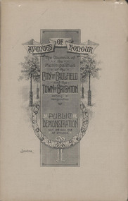 Glen Eira City Council History and Heritage Collection
Booklet, "AVENUES OF HONOUR The Councils of the Municipalities of the CITY OF CAULFIELD TOWN OF BRIGHTON acting in conjunction PUBLIC DEMONSTRATION SAT 3rd AUG. 1918 AT 3oCLOCK"
... but a grand arboreal Avenue of Honour once lined parts of North Road... arboreal Avenue of Honour once lined parts of North Road, McMillan ...Souvenir Programme from the Councils of the Municipalities of the City of Caulfield and the Town of Brighton for a Public Demonstration to be held on Sat 3rd August 1918 at 3 o'clock for the proposed Avenues of Honour to be planted in memory of fallen WWI soldiers. From Honour Roll Display 2019 interpretation panel - Brighton-Caulfield Avenue of Honour It is hard to imagine but a grand arboreal Avenue of Honour once lined parts of North Road, McMillan Street and Point Nepean Road (now Nepean Highway). The Avenue of Honour was a distinctly Australian phenomenon with hundreds being constructed throughout Australia during and following World War One, most of these in Victoria. Consisting of tree lined streets with each tree representing a solider, the Avenue of Honour signalled a more egalitarian approach to commemoration where rank was not a consideration. Arguably the most famous Avenue of Honour in Victoria still exists at Ballarat. Stretching for nearly 22 kilometres, the entrance to the Avenue is marked by the imposing Arch of Victory. Smaller in scale, the Brighton-Caulfield Avenue of Honour was dedicated to the ‘memory of (Brighton and Caulfield’s) kith and kin who came from (the) district and who died in the Great War’. A joint project between the neighbouring Councils, the idea was first reported in The Argus on 1 July 1918. Plans moved along quickly and on 3 August 1918 the Governor of Victoria Arthur Stanley planted the first Australian flowering gum. The next of kin were then invited to plant trees for lost sons, brothers, uncles, nephews and husbands. In all, over 400 trees were planted. Intensely personal, the Avenue also acted as a focus of grief and remembrance for the wider community. For many years, the annual civic Anzac Day service was held at the Avenue on Point Nepean Road, near Glen Huntly Road, Elsternwick. The service was moved to Caulfield Park upon the completion of the Cenotaph in 1930. Due to road widening and disease the last original tree was replaced in the 1980s, however a plaque in Caulfield Park records the Avenue’s plantation. Commemorative booklet, grey cover with text printed on the grey textured paper cover and an image of four trees and a wreath. Image of a kookaburra on the back. Inside, 28 numbered pages with b/w text and photographic images including a transparent paper representation of the proposed Avenues of Honour on Brighton Road and Point Nepean Road. Souvenir programme for a Public Demonstration for the Avenues of Honour as detailed on the front.city of caufield, world war one, first world war, anzac, remembrance, town of brighton, brighton, caulfield, avenue of honour -
 Kew Historical Society Inc
Plan - Subdivision Plan, St Helliers Estate, Kew, circa 1910, c.1910
... the Genazzano Convent to the north of Cotham Road, the Reservoir, St... and Cotham and Burke Roads, over 100 lots were offered for sale ...Pru Sanderson, in her groundbreaking ‘City of Kew Urban Conservation Study : Volume 2 - Development History’ (1988), summarised the periods of urban development and subdivisions of land in Kew. The periods that she identified included 1845-1880, 1880-1893, 1893-1921, 1921-1933, 1933-1943, and Post-War Development. These periods were selected as they represented periods of rapid growth or decline in urban development. An obvious starting point for Sanderson’s groupings involved population growth and the associated economic cycles. These cycles also highlighted urban expansion onto land that was predominantly rural, although in other cases it represented the decline and breakup of large estates. A number of the plans in the Kew Historical Society’s collection can also be found in other collections, such as those of the State Library of Victoria and the Boroondara Library Service. A number are however unique to the collection.Subdivision plans are historically important documents used as evidence of the growth of suburbs in Australia. They frequently provide information about when the land was sold on which a built structure was subsequently constructed as well as evidence relating to surveyors and real estate and financial agents. The numerous subdivision plans in the Kew Historical Society's collection represent working documents, ranging from the initial sketches made in planning a subdivision to printed plans on which auctioneers or agents listed the prices for which individual lots were sold. In a number of cases, the reverse of a subdivision plan in the collection includes a photograph of a house that was also for sale by the agent. These photographs provide significant heritage information relating house design and decoration, fencing and household gardens.In the subdivision of part of Crown Portion 82, bordered by John and Sackville Streets and Cotham and Burke Roads, over 100 lots were offered for sale. In addition to the designated lots, a number of key locations are also identified. These include the Genazzano Convent to the north of Cotham Road, the Reservoir, St Hilary’s and the land holding of Colonel Parnell on the corner of John Street and Cotham Road. On the Plan, No. 5064, is the handwritten name ‘St. Hellier’s Estate’. St. Helliers, the home of the Dumaresq family is shown beside St. Hilary’s.subdivision plans - kew, st helliers estate -
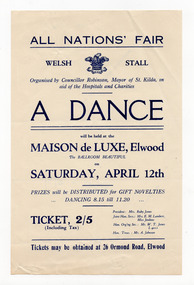 St Kilda Historical Society
Ephemera - Flyer, All Nations' Fair Dance, 1930
... was on the north corner of Glenhuntly Road and Broadway in Elwood... Palais was on the north corner of Glenhuntly Road and Broadway ...Advertisement for a dance, organised by the Mayor of St Kilda in aid of hospitals and charities, at the Maison de Luxe, Elwood on 12 April 1930. The Maison de Luxe Dance Palais was on the north corner of Glenhuntly Road and Broadway in Elwood and operated as a venue for dances and private parties from the late 1920s until the mid 1950s (except when occupied by the Army in 1942-1945).White paper, discoloured with age, printed in blue on one side.On reverse side, written in pencil: '500 - 8/4/30'hospital fundraising, maison de luxe, all nations fair, elwood -
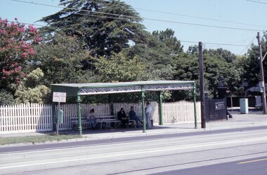 Melbourne Tram Museum
Slide - Set of 17 - Tramway Shelters, Robert Green, c1990
... , St. Georges Road, North Fitzroy 17 - Merri Creek Bridge, St..., St. Georges Road, North Fitzroy 17 - Merri Creek Bridge, St ...Set of 17 colour slides of tramway shelters, poles, and substations by Robert Green c1990. Shelters by the PMTT, HTT and MMTB 1 Tramway Shelter (PMTT) - Cnr Balaclava and Orrong Road, Caulfield 2 - ditto 3 - Tramway Shelter (PMTT) - Cnr. Cotham Road and Burke Road, Deepdene 4 - Tramway Shelter (PMTT) - Cnr. Cotham Road and Burke Road, Deepdene with telephone box alongside. 5 - Cnr. Malvern Rd and Orrong Road, Toorak 6 - Cnr. Malvern Rd and Orrong Road, Toorak 7 - Cnr. Dandenong Road and Hawthorn Road, Caufield 8 - ditto 9 - PMTT Substation - Rusden Street, Elsternwick 10 - PMTT poles cnr. Dandenong Road and Wattletree Road 11 - Tram shelter (HTT) Riversdale Road and Highfield Road - Camberwell - Highfield Park 12 - Tram shelter (HTT) Riversdale Road and Wattlevalley Road, Camberwell 13 - ditto 14 - Tram shelter (HTT) Camberwell Road, cnr Bowen St. Camberwell. 15 - Tram Shelter (HTT) Camberwell Depot, Riversdale Road, Hawthorn 16 - Merri Creek Bridge, St. Georges Road, North Fitzroy 17 - Merri Creek Bridge, St. Georges Road, North Fitzroy - foundation stone Yields information about Melbourne's tramway stop shelters and other infrastructure.Set of 17 Kodak colour slides in plastic mounts.tramways, shelters, caufield, deepdene, toorak, orrong road, cotham road, balaclava road, pmtt, htt, mmtb, riversdale road, camberwell depot, merri creek bridge, foundation stone, dandenong road, poles, rusden st, substations, hawthorn road, st.georges road -
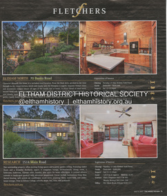 Eltham District Historical Society Inc
Document - Property Binder, 1514 Main Road, Research
... sale of 70 Banks Road Eltham North. Newspaper advertisement... sale of 70 Banks Road Eltham North. Newspaper advertisement ...Newspaper advertisement: The Weekly Review, 11 July 2012, Fletchers estate agent sale of 1514 Main Road Research. Newspaper advertisement: The Weekly Review, 11 July 2012, Fletchers estate agent sale of 70 Banks Road Eltham North. Newspaper advertisement: The Weekly Review, 11 July 2012, Fletchers estate agent sale of 1/45 Beard Street Eltham.main road, property, research (vic.), fletchers real estate, eltham (vic), eltham north (vic) -
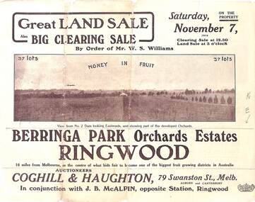 Ringwood and District Historical Society
Pamphlet - Auction Sale, Berringa Park Orchards Estate, Ringwood, Victoria - 1914
... , and Williams Road, North Ringwood. Auctioneers: Coghill & Haughton, 79..., and Williams Road, North Ringwood. Auctioneers: Coghill & Haughton, 79 ...Multi-fold brochure advertising public auction of 37 lots on Saturday 7th November, 1914. Brochure includes terms of sale, description of subdivision features and local facilities, and photographic images of the area. Three-page Park Orchards Estate Price List attached.Subdivison includes Smedley Road, Oban Road, Berringa Road, and Williams Road, North Ringwood. Auctioneers: Coghill & Haughton, 79 Swanston Street, Melbourne, in conjunction with J.G. McAlpin, Ringwood. Brochure includes Clearing Sale to be held same day for "everything required to work these orchards, from a packing needle to a traction engine ... comprising the most up-to-date and extensive farm & chaffcutting plant in this great district". -
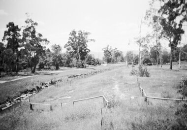 Ringwood and District Historical Society
Photograph, Series of 4 photos from Wantirna Rd Bridge over Dandenong Creek and Gold Course. Ringwood January 1979
... / SS0357c: "looking north." (along Wantirna Road) 2674-4 / SS0357d... / SS0357c: "looking north." (along Wantirna Road) 2674-4 / SS0357d ...4 Black and White photographs. Written on back of photographs - all prefixed "Jan '79. :Standing on top of concrete pole at end of handrail - Wantirna Rd. bridge over Dandenong Creek -" 2674-1 / SS0357a: "looking east along creek." 2674-2 / SS0357b: "looking north-east." 2674-3 / SS0357c: "looking north." (along Wantirna Road) 2674-4 / SS0357d: "looking west over gold club." -
 Greensborough Historical Society
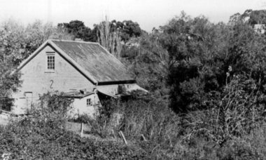
Photograph, Willis Vale 1906, taken from the hill, 1906_
... a fire originating from North Plenty Gorge - Kurrak Road - lit...Greensborough Historical Society 34A Glenauburn Road Lower ...'Willis Vale' home of the Partington family is shown in this photograph as well as the area now known as Partington's Flat. The area was owned and farmed by the Partington family from the 1870s. The derelict Willis Vale house was destroyed in 1964 when a fire originating from North Plenty Gorge - Kurrak Road - lit by two teenage boys - made its way several kilometres down to Partington's Flat Greensborough.Photograph shows an early view of Greensborough in 1906.Professional photograph in sepia mounted on dark green card. Shows Greensborough township in background with Willis Vale homestead in centre. On back: A.M.Partington Greensborough 1906.willis vale, partington family, greensborough, alan partington -
 Greensborough Historical Society
Photograph - Digital Image, Willis Vale, 1950c
... originating from North Plenty Gorge - Kurrak Road - was lit by two...Greensborough Historical Society 34A Glenauburn Road Lower ...House built by Edward Maygar, Robert Whatmough lived there mid 19th century and later sold to Partington family. It was located on the Plenty River at Partington's Flat Greensborough. The derelict Willis Vale house was destroyed in 1964 when a fire originating from North Plenty Gorge - Kurrak Road - was lit by two teenage boys and made its way several kilometres down to Partington's Flat Greensborough.Willis Vale was one of the earliest homes built in the area.Black and white digital photograph.willis vale, partington family -
 Melbourne Tram Museum
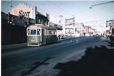
Photograph - Colour Print, Keith Stodden, 1959
... in Glenhuntly road, just prior to the Elsternwick station level crossing... on the north side of the road with signs for Turf tobacco, The Sun ...Colour print of X1 class tram No. 677 eastbound in Glenhuntly road, just prior to the Elsternwick station level crossing. Shows the railway overhead structures, shops on the north side of the road with signs for Turf tobacco, The Sun, The Age, the Rex?? and an advertisement board for Hoyts. Photo shows the crossover just before the level crossing. From a slide by Keith Stodden. Printed on Fujichrome Crystal Archive paper.On rear in black ink "Elsternwick 1959 from slide by Keith M. Stodden"trams, tramways, elsternwick, glenhuntly rd, x1 class, level crossings, tram 677 -
 Greensborough Historical Society
Photograph - Digital image, Willis Vale, 1939c
... originating from North Plenty Gorge - Kurrak Road - was lit by two...Greensborough Historical Society 34A Glenauburn Road Lower ...Willis Vale: House built by Edward Maygar, Robert Whatmough lived there mid 19th century and later sold to Partington family. It was located on the Plenty River at Partington's Flat Greensborough. The derelict Willis Vale house was destroyed in 1964 when a fire originating from North Plenty Gorge - Kurrak Road - was lit by two teenage boys and made its way several kilometres down to Partington's Flat Greensborough.Home of the Partington family.Digital copy of black and white photograph.willis vale, partington family, maygar family, whatmough -
 Greensborough Historical Society
Drawing, Willis Vale by Sharyn Partington, 1983_
... a fire originating from North Plenty Gorge - Kurrak Road...Greensborough Historical Society 34A Glenauburn Road Lower ...Drawn in 1983 by Sharyn Partington (age 15). Sharyn is the daughter of Trevor and granddaughter of Alan and Wyn Partington. The artwork would have been drawn from photos of the Partington home. The derelict Willis Vale house was vandalized in 1964 destroyed when a fire originating from North Plenty Gorge - Kurrak Road - was lit by two teenage boys and made its way several kilometres down to Partington's Flat Greensborough.An original artwork of the Partington home created by a descendant of the occupants.Pencil drawing on cream art paper. Depicts a view of Willis Vale. In black frame under glass.Signed "Sharyn P. 1983"partington, sharyn partington, willis vale, greensborough -
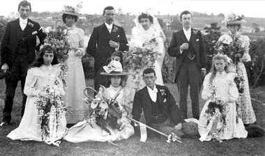 Surrey Hills Historical Society Collection
Photograph, Wedding of Annie Beckett and Henry Leigh at Guildford Villa, 21/9/1899, 21/9/1899
... is to the north with Guildford Road across the photo and Monserrat... Leigh. Background view is to the north with Guildford Road ...Taken at Guildford Villa, which has been demolished, at the wedding of Annie Beckett and Henry Leigh. Background view is to the north with Guildford Road across the photo and Monserrat' on Mont Albert Road on the horizon. Identification: Back row - L to R: Bert Leigh, Katie Beckett, Henry (Harry) Leigh, Annie Beckett, Percy Leigh, Clara Beckett. Front row - L to R: Mabel Beckett, Elsie Beckett, Arthur Leigh, Winnie Leigh. The bride was the daughter of Robert Beckett (senior) of Essex Road and the bridegroom was the son of Timothy Leigh, estate agent and architect of Essex Road. Married at the Wesleyan Church.Both the Beckett and Leigh families were significant in the early days of settlement of Surrey Hills.A B&W photo of bridal party comprised of bride, bridegroom, 3 bridesmaids, 3 male attendants and 2 flowergirls against a largely rural background.guildford villa, weddings, wedding dresses, annie beckett, henry leigh, harry leigh, bert leigh, percy leigh, clara beckett, mabel beckett, elsie beckett, arthur leigh, winnie leigh, topography -
 Bendigo Historical Society Inc.
Document - ALBERT RICHARDSON COLLECTION: CARLISLE UNITED MINE GARDEN GULLY LINE
... north Havilah Road, Boldt Street's corner. 'The Carlisle... was the next mine north Havilah Road, Boldt Street's corner ...Eight page handwritten document with details of the Carlisle United Gold Mine at Long Gully. The lease was 76 acres, 660 yards on line of reef. The Kent shaft was the next mine north Havilah Road, Boldt Street's corner. 'The Carlisle United was formed by the amalgamation of ttte companies, the Old Carlisle, the North Garden and the Passby. These mines were situated on the west side of Bennett Street in about a length of a few hundred feet, with the Passby on the Casley Street corner. And the old Carlisle and North Garden only recently being unearthed beneath the Unity, 'Carlisle' sand heap.' Details about the mining plant, the main shaft, the winding engine air compressor, stone crusher, and engine house are given. The Kent shaft and steel poppet legs are described. Four early claims on the Carlisle United ground are listed: Morgan, Kirshner and Co., Boyd and Co. Claim, Shanks and Co's claim and Day and Co's claim.bendigo, mining, carlisle united -
Glen Eira Historical Society
Document - St. Stephen’s Presbyterian Church, Caulfield
... , 158 Balaclava Road Caulfield North, formerly St. Stephen’s... Indonesian Uniting Church, 158 Balaclava Road Caulfield North ...Two A4 pages handwritten notes dated 23/08/2002, written by Keith Stodden regarding the Caulfield Indonesian Uniting Church, 158 Balaclava Road Caulfield North, formerly St. Stephen’s Church. Details very briefly the closure and re-opening of the church in 2001. Also included is an order of service for a service on 18/08/2012 which combined with Elsternwick Uniting Church that week to worship together. The program is written in Indonesian.stodden keith, porter ian rev. dr., caulfield, balaclava road, elsternwick, caulfield north, uniting church, presbyterian church, caulfield indonesian uniting church, st. john’s presbyterian church, elsternwick uniting church, st. stephen’s uniting church, st. stephen’s presbyterian church, religious ceremonies, religious groups, stained glass, events and activities, programs, religious structures an d establishments, languages, ethnic communities, indonesian community