Showing 880 items matching "paths"
-
 Phillip Island Conservation Society Inc.
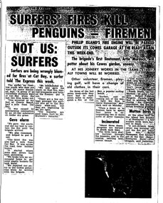
Work on paper - Photocopy of newspaper cutting, The Express, "SURFERS' FIRES KILL/ PENGUINS - FIREMEN//NOT US:/SURFERS"
Written during the 1960s when surfing was burgeoning across Australia’s coast and Phillip Island surf beaches had become extremely popular, few management strategies were in place to control interaction of the public with the delicate flora and fauna of the coastal environments. There were few good access tracks, car parks, bins, toilets etc at coastal/surfing hotspots around the Phillip Island coast. A number of management issues occurred with the influx of surfers. These included dune erosion caused by surfers climbing dunes to see the surf before going on the beach; informal parking on wildlife habitat; numerous access paths from wherever cars were parked down to the beach cutting through habitat; illegal camping on foreshores; illegal lighting of fires on beach and in dunes; surfers’ dogs let out of the car while surfers were out on the water. The dogs were uncontrolled. Certainly some surfers behaved responsibly, as is almost invariably the case these days. However, in that era of this article few people understood the delicate nature of the coastal environment and that it need to be protected through public education, infrastructure and enforcement of regulations. As now, most rural Fire services were run by dedicated volunteers who faced many challenges in their roles as Country Fire Authority firefighters. However, it was not uncommon for visitors and locals to also assist with fire-fighting efforts.The article is significant in containing quotes from both sides of the discussion who were directly involved in coastal fire incidents on Phillip Island in the 1960s. It also indicates the large number of surfers visiting Phillip Island beaches, the volunteer nature of the firefighting service and the extra challenges they faced on Phillip Island as a visitor destination. The anonymous university student surfer who is quoted, also describes possible causes of the fires, methods he and his fellow surfers used to extinguish the fires and raise the alarm, and the way they assisted the volunteer firefighters . The reference to him breaking into one of the Summerland housing estate holiday houses is also significant because that housing estate was purchased over 2 decades by successive Victorian governments to remove management issues caused to the wildlife habitat on Summerland Peninsula.Photocopy of newspaper cuttings including 2 related articles. Five columns of black text on white paper with one poorly reproduced photo bottom rightphillip island, cat bay, country fire authority, artie murdoch, alf towns, frank dixon, barry thompson, newhaven-san remo rural fire brigade, penguin parade, cowrie beach, surfers, coastal fires -
 Bendigo Military Museum
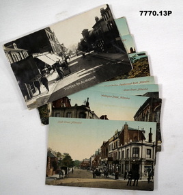
Postcard - POSTCARD, ALDERSHOT, UK, Valentine's Series, c 1914 - 1918
R..H. Baron took leave from Herdcott Camp between 4.10.19918 and 8.10.1918 to visit Aldershot. See Catalogue No. 7743 for leave pass details. Relatives lived in the Aldershot area. Part of the 'Robert H. Baron', No.3596 and Cooper Collections. See Catalogue No. 19819 for details of Baron's service.1. Coloured street scene with buildings, groups of people and horse drawn transport. 2. Coloured street scene with buildings, groups of people and horse drawn transport. 3. Coloured street scene with buildings, groups of people. 4. Coloured scene features a canal with boat, tow path, bridge and house. 5. Coloured, Band marching down a street. Spectators lining the road. Church in background. 6. Coloured Group of soldiers in uniform marching along the road. Spectators, church in background. 7. Coloured statue of a man on a horse. Statue located on a hill 8. Coloured scene of gardens surrounded by buildings and a church. Groups of women. 9. Coloured - Large building with a clock tower. 10. Coloured column of uniformed soldiers on horseback. Buildings lining road. Horse drawn transport sharing road. 11. Coloured street scene with red brick building and pedestrians. 12. Coloured Monument with inscription. Buildings in background. 13. Black and wgite street scene. Street lined with buildings. Horse drawn transport. Pedestrians.1. High Street, Aldershot. 2. Wellington Street, Aldershot. 3. Union Street, Aldershot. Handwritten in black ink on back: (Notice how narrow the streets are). 4. Wharf Bridge, Farnborough Road, Aldershot. Handwritten in black ink on back: "I was all over these places with Uncle. I had a good time in Aldershot, Bob. 5. Wellington Avenue (Church Parade), Aldershot. Handwritten in black ink: 'One of the Aldershot bands', R.H. Baron.' 6. Queens Avenue and St. George's Church, Aldershot. Handwritten in black ink on back: 'Soldiers going to church". 7. Wellington Monumental, Aldershot. Handwritten on back in black ink: 'I was right up around this place!' 8. Municipal Gardens, Aldershot. Handwritten on back in black ink: 'This place is very pretty, Bob'. 9. Cambridge Hospital, Aldershot. Handwritten on back in black ink "This is a fine place!". 10. Hospital Hill, Aldershot. 11. Smith Dorrien Home, Aldershot. Handwritten on back in black ink. 'I was all over Aldershot with Uncle. I have saw all these places. Bob.' 12. R.A.M.C. Memorial, Aldershot. 13. Victoria Rd, Aldershot.robert h. baron, cooper collection, aldershot uk, postcards -
 National Wool Museum
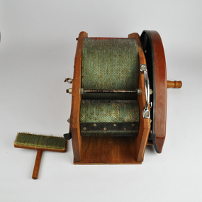
Tool - Drum Carder, Kacoonda, c.1980
This drum carder was purchase by Gill Stange at the Whittlesea Show in the late 1980s. The carder allowed Gill to spin fleece from her own Merino sheep. Merino is a difficult wool to spin when compared to other popular varieties, such as Corriedale or crossbred wool. The carder helped her to tease out the fleece, slightly separating the fibres before spinning. It also allowed for easier removal of foreign matters, such as seeds and mud. Little is known about the Kacoonda brand who produced the carder. They were Australian based and appear to have only operated throughout the 1980s.The carder has one large central roller with two smaller rollers on either side. The larger roller rotates in the inverse direction of the two smaller rollers. The carding cloth is a mint green in which closely spaced wire pins are embedded. The shape, length, diameter, and spacing of these wire pins is that of a standard carder. On one side of the carder a handle is found that is used to spin the three rollers. Additionally on this side is a sticker which reads “The Kacoonda Carder. Subject to Patent Action”. A Silver grip for the easy movement of the carder can also be found high on this side. On the opposite side of the carder, many nuts and plates can be found which hold the rollers in place. This is opposed to the other side of the carder, which has a brown plastic cover plate attached underneath the handle. The walls providing a path for the carded wool to follow when being carded, are made of wood. The carder comes complete with a teasing tool. This tool has the same mint green carding cloth as the carder’s rollers. It is attached to a simple wood handle for ease of use.Wording, green, printed. Sticker on side of carder. “The Kacoonda Carder / SUBJECT TO PATENT ACTION”whittlesea show, drum carder, textile production, carding wool, kacoonda -
 Royal District Nursing Service (now known as Bolton Clarke)
Photograph - Photograph, black and white, c.1960
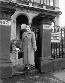
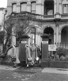
Sister Beryl Hawker is a District Nurse working for the Melbourne District Nursing Service (MDNS) and is leaving their Headquarters at 452 St. Kilda Road, Melbourne to give nursing care to a patient in their home situated in a Melbourne suburb. She is wearing the MDNS winter uniform grey wool coat over her grey cotton dress with white collar. A red Maltese cross is attached to the centre of her grey wool beret. Her nursing case contains an apron, hand towel, thermometer, instruments, dressings and lotions.The Trained nurses of the Melbourne District Nursing Society (MDNS), later known as Royal District Nursing Service (RDNS), visited patients in their home and gave best practice care in many fields of nursing and to people of many cultures throughout its 130 years of expansion. Initial visits not only assessed the specific nursing situation but the situation as a whole. Their patients ranged in age from babes, children, adults to the elderly and referrals were taken from Hospitals, General Practitioners and allied Health facilities. Some of the care provided was: – Post-Natal care given to mother and babe, Wound Care following various types of surgery, accidents, burns, cancer, leg ulcers etc. Supervising and teaching Diabetic Care, including teaching and supervising people with Diabetes to administer their own Insulin, and administering Insulin to those unable to give their own injections. Administering other injections and setting up weekly medication boxes. The Sisters performed Catheterizations on adults suffering from conditions such as Quadriplegia, Paraplegia, Multiple Sclerosis (MS), Motor Neurone Disease (MND) and Guillan-Barre Syndrome, and when required at school on children for e.g. those with Spina Bifida. The Sisters visited those requiring Cystic Fibrosis support and care; those requiring Haemo-Oncology care, including visiting children at school; those requiring Home Enteral Feeding care, and those requiring IV therapy at home and home Dialysis. Palliative Care was given including pain relief with the use of syringe drivers, personal care as needed, and advice and support to both patient and family. RDNS provided Stoma management to those needing Urostomy, Ileostomy and Colostomy care and those requiring Continence care. HIV/AIDS nursing care was provided; visits to Homeless Persons were made. Personal care was given to patients ranging in age and with varying mobility problems, such as those with MS, MND, Guillan-Barre Syndrome, Quadriplegia, Paraplegia, Acquired Brain Injury, following a Cerebrovascular Accident (Stroke), those with severe Arthritis and those with a form of Dementia. When necessary the elderly were assisted with personal care and advice given on safety factors with the use of hand rails, bath or shower seats, and hand showers. Rehabilitation with an aim towards independence remained at the forefront of the Sister’s minds and when possible using aids and instruction on safe techniques enabled the person to become fully independent. All care included giving advice and support to the patient and their Carers. The Sisters liaised with the persons Doctor, Hospital and allied Health personal when necessary.Sister Beryl Hawker, who has short dark hair, is smiling as she is leaving Melbourne District Nursing Service (MDNS) Headquarters. She is wearing the MDNS uniform of an ankle length double breasted grey wool coat and wool beret with a central Maltese cross. Part of the MDNS insignia is seen at the top of her left sleeve. In her right hand she is carrying a rectangular nursing case and a light colour soft material bag. She is standing in front of the open metal spike gate between the two square grey concrete pillars of the gateway; the black numbers '452' are written on a white background on the top section of each pillar. A spiked metal fence is attached and running to the right of the right pillar; attached to this and close to the pillar, is a white plaque with black capital letters reading: 'Melbourne District Nursing Service Headquarters'. In the background is a paved path leading to part of a building with part of three arches seen and above this some concrete balustrade. A large pedestal concrete flower urn sits next to the partially seen steps leading up to the building. Some low bushes are seen behind the fence and in front of the building.59134-11melbourne district nursing service, mdns, mdns uniform, mdns headquarters, sister beryl hawker, royal district nursing service, rdns -
 Eltham District Historical Society Inc
Photograph, Liz Pidgeon, Heritage Excursion; Maroondah Aqueduct, 3 September 2016, 3 September 2016
Heritage Excursion - Maroondah Aqueduct Walk - Saturday 3rd September The Maroondah Aqueduct was once a major link in Melbourne’s water supply system. It was built between 1886 and 1891 to transfer water from the Watts River near Healesville to the Preston Reservoir. It was 66 km in length, made up of 41 km of open channel, 10 km of tunnel through hills and 15 km of pipeline across stream valleys known as inverted siphons. The section of the aqueduct through the Eltham area has been abandoned since the 1980s but the open channel has largely been retained. A recreational path follows the aqueduct reserve. For our excursion on 3rd September we intend to walk along the section of the aqueduct adjacent to Allendale Road. This is a section not visited on previous excursions and includes the transition from open channel to the inverted siphon across the Diamond Creek valley. Apart from the aqueduct itself the main feature of the walk is the extensive views across Eltham North and Diamond Creek. Along the way we will talk about the history of the aqueduct and the area. This easy walk is about 3 km return and will take 2 to 2.5 hours. It will start at 2pm at the junction of Allendale Road with Godber Road and Zig Zag Road North, officially Diamond Creek, but on the northern boundary of Eltham. (Melway ref.12 B10). Newsletter No., 229, August 2016 Abandoned and rusted house base probably purposed to water or feed cattle. Born Digitalmaroondah aqueduct, eltham north, activities, eltham district historical society, heritage excursion, bath, acqueduct trail -
 Eltham District Historical Society Inc
Photograph, Liz Pidgeon, Heritage Excursion; Maroondah Aqueduct, 3 September 2016, 3 September 2016
Heritage Excursion - Maroondah Aqueduct Walk - Saturday 3rd September The Maroondah Aqueduct was once a major link in Melbourne’s water supply system. It was built between 1886 and 1891 to transfer water from the Watts River near Healesville to the Preston Reservoir. It was 66 km in length, made up of 41 km of open channel, 10 km of tunnel through hills and 15 km of pipeline across stream valleys known as inverted siphons. The section of the aqueduct through the Eltham area has been abandoned since the 1980s but the open channel has largely been retained. A recreational path follows the aqueduct reserve. For our excursion on 3rd September we intend to walk along the section of the aqueduct adjacent to Allendale Road. This is a section not visited on previous excursions and includes the transition from open channel to the inverted siphon across the Diamond Creek valley. Apart from the aqueduct itself the main feature of the walk is the extensive views across Eltham North and Diamond Creek. Along the way we will talk about the history of the aqueduct and the area. This easy walk is about 3 km return and will take 2 to 2.5 hours. It will start at 2pm at the junction of Allendale Road with Godber Road and Zig Zag Road North, officially Diamond Creek, but on the northern boundary of Eltham. (Melway ref.12 B10). Newsletter No., 229, August 2016 Abandoned rusty farm machinery possibly used for tilling the soil - off the Aqueduct trail Born Digitalmaroondah aqueduct, eltham north, activities, eltham district historical society, heritage excursion, aqueduct trail, farm machinery -
 Eltham District Historical Society Inc
Photograph, Liz Pidgeon, Heritage Excursion; Maroondah Aqueduct, 3 September 2016, 3 September 2016
Heritage Excursion - Maroondah Aqueduct Walk - Saturday 3rd September The Maroondah Aqueduct was once a major link in Melbourne’s water supply system. It was built between 1886 and 1891 to transfer water from the Watts River near Healesville to the Preston Reservoir. It was 66 km in length, made up of 41 km of open channel, 10 km of tunnel through hills and 15 km of pipeline across stream valleys known as inverted siphons. The section of the aqueduct through the Eltham area has been abandoned since the 1980s but the open channel has largely been retained. A recreational path follows the aqueduct reserve. For our excursion on 3rd September we intend to walk along the section of the aqueduct adjacent to Allendale Road. This is a section not visited on previous excursions and includes the transition from open channel to the inverted siphon across the Diamond Creek valley. Apart from the aqueduct itself the main feature of the walk is the extensive views across Eltham North and Diamond Creek. Along the way we will talk about the history of the aqueduct and the area. This easy walk is about 3 km return and will take 2 to 2.5 hours. It will start at 2pm at the junction of Allendale Road with Godber Road and Zig Zag Road North, officially Diamond Creek, but on the northern boundary of Eltham. (Melway ref.12 B10). Newsletter No., 229, August 2016 Brick bridge on Parsons road, Eltham North over the aqueduct on the aqueduct trail. Born Digitalmaroondah aqueduct, eltham north, activities, eltham district historical society, heritage excursion, parsons road, bridges, aqueduct trail -
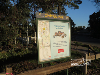 Eltham District Historical Society Inc
Photograph, Liz Pidgeon, Heritage Excursion; Eltham Lower Park, 1 July 2017
Civic Guide sign near the entrance of Eltham Lower Park with a map of the local area and an advertisement for Eltham College Newsletter No., 234, June 2017 Heritage Excursion - Saturday 1st July - Eltham Lower Park - Walk and Talk Eltham Lower Park has played an important part in the history of our area since the early days of European settlement when it was used by local residents as an informal racecourse. Prior to that its location at the junction of the Diamond Creek and the Yarra River made it an important meeting place for the Wurundjeri people. The park combines formal elements and sporting facilities with remnant bushland that is of environmental significance. It is home to sporting and horse riding clubs, popular play spaces and the Diamond Valley Miniature Railway, which attracts large numbers of visitors. The park will be the venue for our July excursion which will comprise a walk of about 3.5 km around the park and adjacent areas. Along the way we will discuss the history and natural history of the area. The path along the creek and the river provides a pleasant and scenic walk. This walk on Saturday 1st July is about 3.5 km in length and will take 2 to 2.5 hours. It will start at 2pm at the Main Road car park at the front of the park. (Melway ref 21 H 10). This sign was removed in about 2021 when works began on the building of an intersection to replace the roundabout at Fitzsimons Lane & Main Road. By May 2023 plantings in green spaces near Eltham Lower Park took place before the official opening of the new Eltham Gateway.Born Digitalheritage excursion, activities, eltham district historical society, eltham lower park, civic guide, eltham college, sign -
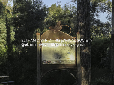 Eltham District Historical Society Inc
Photograph, Liz Pidgeon, Heritage Excursion; Eltham Lower Park, 1 July 2017
Sign at the front of the park which includes a map. Newsletter No., 234, June 2017: Heritage Excursion - Saturday 1st July - Eltham Lower Park - Walk and Talk Eltham Lower Park has played an important part in the history of our area since the early days of European settlement when it was used by local residents as an informal racecourse. Prior to that its location at the junction of the Diamond Creek and the Yarra River made it an important meeting place for the Wurundjeri people. The park combines formal elements and sporting facilities with remnant bushland that is of environmental significance. It is home to sporting and horse riding clubs, popular play spaces and the Diamond Valley Miniature Railway, which attracts large numbers of visitors. The park will be the venue for our July excursion which will comprise a walk of about 3.5 km around the park and adjacent areas. Along the way we will discuss the history and natural history of the area. The path along the creek and the river provides a pleasant and scenic walk. This walk on Saturday 1st July is about 3.5 km in length and will take 2 to 2.5 hours. It will start at 2pm at the Main Road car park at the front of the park. (Melway ref 21 H 10). This sign was removed in about 2021 when works began on the building of an intersection to replace the roundabout at Fitzsimons Lane & Main Road. By May 2023 plantings in green spaces near Eltham Lower Park took place before the official opening of the new Eltham Gateway. The sig Born Digitalelection day, heritage excursion, activities, eltham district historical society, eltham lower park, sign -
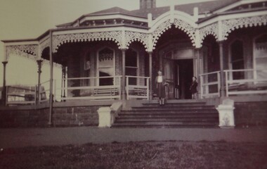
 Royal Australian and New Zealand College of Obstetricians & Gynaecologists (RANZCOG)
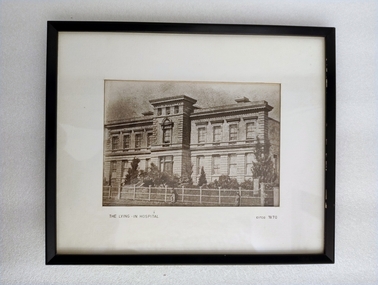
Photograph - Reproduction photograph, Charles Nettleton (1826-1902), The Lying In Hospital, circa 1870, c. 1868
This a cropped reproduction of a photograph taken by Charles Nettleton in c. 1868. Founded in 1856, the Lying-in Hospital was the second hospital to be established in Melbourne, after the Melbourne Hospital. It was, however, the first lying-in hospital in the Australasian colonies. The hospital was founded in a converted private house "Fairmont", which was located at 41 Albert Street, Eastern Hill (now East Melbourne). In 1858, the 'Lying-in Hospital' was relocated and opened in Madeline St, North Melbourne (now known as Swanston St, Carlton)." (The Women's) The building pictured here was eventually demolished in 1938 to make way for further extensions to the building. The original site in Albert Street was demolished in 1960, and the site is now occupied by the Melbourne Fire Brigade. A section of the wrought iron gates from the original site in Albert Street is held in RANZCOG's historical collection.Reproduction photograph of the front of a building. The building is three stories high. The lowest floor has eight large windows, with a door at centre, on the front side. One side window can also be seen at bottom right. There is a small flight of stairs leading up to the door. The second floor has eight windows in the same locations as the first floor, plus one additional window at centre instead of a door. The top floor is much smaller, with three small windows facing the front of the building. There are trees in the grounds in from of the building. House and grounds are enclosed behind a fence. There is a gate in the fence opposite the front door. Three figures are visible on the path outside the fence. One is at the centre of the image, and the other two are in the right hand corner. Text printed below image reads 'THE LYING - IN HOSPITAL circa 1870'. The image has been mounted and framed in a black wooden frame. An old display label for this image is attached to the back of the frame. handwritten text on backing board at back of work reads 'Probably prior to 1867 (J. Nattrass, 1968). Tape residue visible on backing board at upper right. A chain and two hooks have been added to the frame for hanging. -
 Bendigo Military Museum
Photograph - Johnson Ground Elevation Meter (JGEM) Survey Vehicle - Army Survey Regiment, Fortuna, Bendigo, c1960s
This is a set of 16 photograph of the Royal Australian Survey Corps’ Johnson Ground Elevation Meter (JGEM) Survey Vehicle taken at the Army Survey Regiment, Fortuna, Bendigo. The JGEM vehicle was extensively used by RA Svy within Australia from the late 1960s. A limited number of Ground Elevation Meter (GEM) station wagon type vehicles were manufactured by General Motors Corporation (GMC) in the USA for the United States Geological Survey, Canada’s mapping agencies, RA Svy and National Mapping (Natmap). The GEM was a four-wheel drive, four-wheel steer vehicle. Four-wheel steering was necessary to avoid systematic errors caused by non-tracking of front and rear wheels on conventionally steered vehicles. The manufacturer substituted the rear axle with a front axle and connected them to form the four-wheel steering mechanism. The two Australian GEM vehicles, referred to as Johnson GEMs (JGEMs) were converted into right-hand drive. After delivery in 1964, acceptance Natmap and RA Svy testing and operator training was undertaken at the Army's School of Military Survey located at Balcombe, Victoria. A small fifth wheel was mounted on a cantilever arm suspension midway between the front and rear wheels on the right side of the vehicle. It was lowered to and raised from its operating position by use of a constant pressure air cylinder. A telescopic bar, suspended between the front and rear axles, provided the reference datum for the angle measurement. The wheel provided the velocity or distance signal through a pulse generator system. A sensitive pendulum mounted on this bar provided the angle measurement for each minute distance traversed. The JGEM contained electromechanical instruments used to determine relative elevations, by trigonometric principles, along a traversed path. These relative elevations were obtained through apparatus which measures the instantaneous angle of inclination of the road and the instantaneous velocity of the meter along such a path. Road routes over which the JGEM operated were planned so that each started and ended as near as practicable to an existing point of known elevation (formally referred to as a level traverse bench mark). The difference in height from the bench mark and the road surface alongside the JGEM’s fifth wheel was measured with a level and staff. Along each route, mapping control photo reference points where new elevation values were required were identified on aerial photographs. Under favourable conditions it was possible to survey as much as 160km in an ordinary working day. The first of RA Svy’s JGEM operations was undertaken in 1:250,000 scale map areas of Queensland. CPL John Hook was the JGEM’s main operator in the early 1970s undertaking operations covering 1:250,000 scale map blocks over northern Victoria and central NSW, each requiring 36 points (9 runs of photography and 4 points across. SPR Lyn Thompson and SPR Bob McDonagh teamed with CPL Hook on some of these JGEM operations. When RA Svy was integrated into the Royal Australian Engineers in 1996, the JGEM vehicle with the Survey Corps collection was donated to its museum. It is believed to be the last of the original manufactured fleet in existence. The JGEM has undergone extensive refurbishment to achieve roadworthiness and is currently housed at The Australian Army Museum of Military Engineering, Hoslworthy Barracks, NSW. It can be viewed by making an appointment with the museum’s curator.This is a set of 16 photograph of the Royal Australian Survey Corps’ Johnson Ground Elevation Meter (JGEM) Survey Vehicle taken at the Army Survey Regiment, Fortuna, Bendigo. The photographs were on 35mm slide film and were scanned at 96 dpi. They are part of the Army Survey Regiment’s Collection. .1) - Photo, colour, c1960s, Johnson Ground Elevation Meter (JGEM) Survey Vehicle .2) - Photo, colour, c1960s, JGEM instrumentation, on-board computer. .3) - Photo, colour, c1960s, JGEM instrumentation. .4) - Photo, colour, c1960s, JGEM instrumentation, on-board computer. .5) - Photo, colour, c1960s, JGEM tyre pressure controller .6) - Photo, colour, c1960s, JGEM rear doors, SGT Geoff Briggs. .7) - Photo, colour, c1960s, JGEM 5th wheel distance/angle measurement device in lowered position, SGT Geoff Briggs. .8) - Photo, colour, c1960s, JGEM 5th wheel distance/angle measurement device in lowered position. .9) & .10) - Photo, colour, c1960s, JGEM tyre pressure system, SGT Geoff Briggs. .11) - Photo, colour, c1960s, JGEM tyre pressure system. SGT Geoff Briggs. .12) - Photo, colour, c1960s, JGEM levelling scope, levelling staff, unidentified technicians. .13) & .14) - Photo, colour, c1960s, JGEM levelling scope, unidentified technician. .15) & .16) - Photo, colour, c1960s, probably survey operation adjusted height plotted on block base sheet. .1P to .16P - Some of the equipment is annotated on the frame of the 35mm slides.royal australian survey corps, rasvy, army survey regiment, army svy regt, fortuna, asr, surveying -
 Federation University Historical Collection
Photograph - Photograph - Colour, VIOSH: Reducing Back Injuries and Energy Costs of Shearing through the Development of Practical Modifications to Shed Layout, 1995-1997
Victorian Institute of Occupational Safety and Health (VIOSH) Australia is the Asia-Pacific centre for teaching and research in occupational health and safety (OHS) and is known as one of Australia's leaders in the field. VIOSH has a global reputation for its innovative approach within the field of OHS management. VIOSH had its first intake of students in 1979. At that time the Institution was known as the Ballarat College of Advanced Education. In 1990 it became known as Ballarat University College, then in 1994 as University of Ballarat. It was 2014 that it became Federation University. VIOSH Australia students are safety managers, senior advisors and experienced OHS professionals. They come from all over Australia and industry. Students are taught active research and enquiry; rather than textbook learning and a one-size fits all approach. VIOSH accepts people into the Graduate Diploma of Occupational Hazard Management who have no undergraduate degree - on the basis of extensive work experience and knowledge. A project titled "Reducing Back Injuries and Energy Costs of Shearing Through the Development of Practical Modifications to Shed Layout" was funded by Worksafe Australia. The budget was $101,170. VIOSH Australia collaborated with the School of Human Movement and Sports Science to look for ways to reduce muscle injuries associated with shearing. The study set up a number of focus groups in the Ballarat area, New South Wales and Western Australia to gather different inputs and perspectives on causes of injuries. Groups represented were shearers, doctors, farmers and shearing shed designers. Shed design was a principal factor with the emphasis on minimising body twisting associated with catching and releasing sheep, removal of floor obstructions along path between pen and release, battens oriented along direction of drag and slope in pens.Colour photographs - postcard and A5 - relating to reducing back injuries and Energy Costs of Shearing.viosh, victorian institute of occupational safety and health, worksafe australia, back injuries, shearing sheds, shearers, school of human movement and sports science, ballarat, new south wales, western australia, doctors, farmers, shed designers -
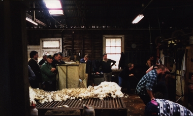 Federation University Historical Collection
Photograph - Photograph - Colour, VIOSH: Shearing Shed Demonstrations - Collaboration with School of Human Movement and Sports Science; ways to reduce muscle injuries - 1994-1997
.Victorian Institute of Occupational Safety and Health (VIOSH) Australia is the Asia-Pacific centre for teaching and research in occupational health and safety (OHS) and is known as one of Australia's leaders in the field. VIOSH has a global reputation for its innovative approach within the field of OHS management. VIOSH had its first intake of students in 1979. At that time the Institution was known as the Ballarat College of Advanced Education. In 1990 it became known as Ballarat University College, then in 1994 as University of Ballarat. It was 2014 that it became Federation University. VIOSH Australia students are safety managers, senior advisors and experienced OHS professionals. They come from all over Australia and industry. Students are taught active research and enquiry; rather than textbook learning and a one-size fits all approach. VIOSH accepts people into the Graduate Diploma of Occupational Hazard Management who have no undergraduate degree - on the basis of extensive work experience and knowledge. A project titled "Reducing Back Injuries and Energy Costs of Shearing Through the Development of Practical Modifications to Shed Layout" was funded by Worksafe Australia. The budget was $101,170. VIOSH Australia collaborated with the School of Human Movement and Sports Science to look for ways to reduce muscle injuries associated with shearing. The study set up a number of focus groups in the Ballarat area, New South Wales and Western Australia to gather different inputs and perspectives on causes of injuries. Groups represented were shearers, doctors, farmers and shearing shed designers. Shed design was a principal factor with the emphasis on minimising body twisting associated with catching and releasing sheep, removal of floor obstructions along path between pen and release, battens oriented along direction of drag and slope in pens.Thirty-one colour photographs on inside a shearing shedviosh, victorian institute of occupational safety and health, 1995-1997, shearing shed layout, worksafe australia, school of human movement and sports science, shearers, doctors, farmers, muscle injuries, university of ballarat, student activity -
 Glen Eira Historical Society
Album - Album page, Normanby Road, Circa 1972
This photograph is part of the Caulfield Historical Album 1972. This album was created in approximately 1972 as part of a project by the Caulfield Historical Society to assist in identifying buildings worthy of preservation. The album is related to a Survey the Caulfield Historical Society developed in collaboration with the National Trust of Australia (Victoria) and Caulfield City Council to identify historic buildings within the City of Caulfield that warranted the protection of a National Trust Classification. Principal photographer thought to be Trevor Hart, member of Caulfield Historical Society. Most photographs were taken between 1966-1972 with a small number of photographs being older and from unknown sources. All photographs are black and white except where stated, with 386 photographs over 198 pages. From: Glen Eira Heritage Management Plan (1996) - Vol 2 by Andrew Ward and Associates The widening of Dandenong Road during the late 1980's has resulted in the destruction of the houses in the path of the roadworks and the construction of a high fence serving as a visual barrier between that thoroughfare and the remaining houses. Where comparatively large villas once stood on spacious allotments, only "Wisteria" survives at No. 135 Normanby Road. Adopting forms and timber enrichment characteristic of the American Queen Anne style, it has this in common with the largely reconstructed timber villa at no. 11 Normanby Avenue and to a lesser extent, 746 Inkerman Road. Normanby Road retains its comparatively opulent Edwardian character in a mature landscaped setting with spacious gardens and mature planes parallel with the railway reserve which, on account of the low lying ground in its vicinity has a high embankment commencing on the alignment of Malvern Grove and continuing to Caulfield Station. The earliest villas are Edwardian. Page 148 of Photograph Album with one landscape photograph of a house on Normanby Road (not Street).Handwritten: Normanby St [top right] / 148 [bottom right]trevor hart, verandah, porch, bull nosed verandah, tower house, tower, stone fence, normanby road, wisteria, american queen anne style, queen anne style, 1890's, mayfield grove, normanby street, timber houses, caulfield north, house names, edwardian, edwardian style, gardens -
 Eltham District Historical Society Inc
Photograph, Fay Bridge, Remains of apple orchard near the Diamond Creek, Wattle Glen, 11 October 2018
The newly constructed Diamond Creek Trail from Diamond Creek to Wattle Glen completed in February 2021 winds past these apple trees that possibly lined the entrance to the Greenhills property From Jean Verso, Nillumbik Historical Society, 15 April 2021 William Wandless Herbert bought the surrounding 100 acres in 1852. He was a native of Northumberland and the Scottish Borders who arrived in Melbourne in 1847. The house on the top of the mound would have been built not long after he bought the land; the farm was named "Greenhills". He married Elizabeth Wilson, daughter of John Wilson who had been in Diamond Creek since about 1846. Their first child was born in 1854 so there would be some form of dwelling from about that time. They had eight children who all survived to a good age. His will describes the house as part stone and part wood and of four rooms. Nillumbik Historical Society (NHS) believe it was one of the earliest if not the earliest house, in this part of the district. The remains of the stone house foundations are on top of the mound (photos on the VHD page) and the barn walls are on the north and to the east side of the mound. NHS is not sure how much or which part of the surrounding area was covered by the barns but they were large enough to hold dances after the race meetings that were held in the late 1880's on the adjacent creek flats. It would make sense with the lay of the land that they covered some of the ground to the north and east and used for farm storage, packing sheds for their apple and pear orchards and also for supporting the Nillumbik Gold Mine the family worked to the north up the gully. The path that comes down the gully and runs into the trail goes past the mine site which was on the west side of the gully a couple of hundred metres up from the flats. Heritage Victoria link for the site - https://vhd.heritagecouncil.vic.gov.au/places/12203fay bridge collection, 2018-10-11, diamond creek, diamond creek trail, elizabeth wilson, greenhills, wattle glen, william wandless herbert, apple trees -
 Eltham District Historical Society Inc
Photograph, Liz Pidgeon, Heritage Excursion; Eltham Lower Park Walk and Talk, 1 July 2017, 1 July 2017
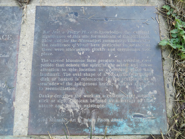
Transcription of plaque: Not Just a Pretty Place acknowledges the cultural significance of this site for residnets of the Nillumbik Shire and for the Wurundjeri community. Historically the confluence of rivers have particular importance as these were sites where rituals and ceremonies took place. The carved bluestone form presents an oversize river pebble that echoes the spirit of the water and draws attention to this location as a meeting place and landmark. The oval shape of a coolamun (Wurundjeri dish or basket) is referenced in the sculpture as a reminder of the indigenous heritage and as a gesture to reconciliation Danko describes the work as a contemporary message stick or sign, that can be read as a merker of time, nature and human existance. 2000 Nillumbik Art in Public Places Award. Heritage Excursion - Saturday 1st July - Eltham Lower Park - Walk and Talk Eltham Lower Park has played an important part in the history of our area since the early days of European settlement when it was used by local residents as an informal racecourse. Prior to that its location at the junction of the Diamond Creek and the Yarra River made it an important meeting place for the Wurundjeri people. The park combines formal elements and sporting facilities with remnant bushland that is of environmental significance. It is home to sporting and horse riding clubs, popular play spaces and the Diamond Valley Miniature Railway, which attracts large numbers of visitors. The park will be the venue for our July excursion which will comprise a walk of about 3.5 km around the park and adjacent areas. Along the way we will discuss the history and natural history of the area. The path along the creek and the river provides a pleasant and scenic walk. This walk on Saturday 1st July is about 3.5 km in length and will take 2 to 2.5 hours. It will start at 2pm at the Main Road car park at the front of the park. (Melway ref 21 H 10). From Newsletter No., 234, June 2017 Born Digitalelection day, heritage excursion, activities, eltham district historical society, eltham lower park, not just a pretty place, public art, plaque -
 Eltham District Historical Society Inc
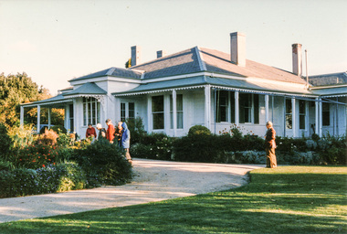
Photograph, Mulberry Hill, Golf Links Road, Baxter; Spring Excursion to The Briars and Mulberry Hill, 27 October 1991, 27/10/1991
[from EDHS Newsletter No. 80, September 1991:] SPRING EXCURSION: As usual for October we have arranged a bus tour outside the local area. We will leave from the Eltham Shire Offices at 9.00 am on Sunday 27th October and travel to "The Briars" at Mornington and "Mulberry Hill" at Baxter. The cost will be $16.00 for adults and $8.00 for children. This includes admission to each of the houses and afternoon tea at "Mulberry Hill". Bring your own lunch to eat at "The Briars" and something for morning tea if you wish. "The Briars" is one of the oldest pastoral stations on the Mornington Peninsula. It has historical associations with the early settlement of the district and with Alexander Balcombe who settled in the area about 1843. Near the house is a wetland wildlife reserve with walking paths and bird observation hides. "Mulberry Hill" was the home of Sir Darryl Lindsay and his wife Joan. Darryl (1889-1976) was a member of the famous art family of Lindsays and was a prominent artist in his own right. He was also a noted art administrator, being appointed Director of the National Gallery of Victoria in 1942. Joan Lindsay (1896-1984) was an important writer. Her best known work was "Picnic at Hanging Rock". Members may find it interesting to read her autobiography "Time Without Clocks" prior to this trip. Members are welcome to bring their friends. Bookings will only be confirmed on payment. Please complete the attached form and return with payment to the September meeting or to our post office box. The trip is still some time off but there is no further Newsletter before then. Note the date in your diary how. As this will probably be the first day of daylight saving you will need to remember that in organizing yourself on the day. Please arrive at 8.45 am ready for a prompt start at 9.00 am.Two colour photographsactivities, mulberry hill, the briars -
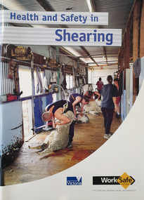 Federation University Historical Collection
Booklet - Booklet - Safety, Worksafe Victoria, VIOSH: Victorian Workcover Authority; "Health and Safety In Shearing, 2001", 2001
Victorian Institute of Occupational Safety and Health (VIOSH) Australia is the Asia-Pacific centre for teaching and research in occupational health and safety (OHS) and is known as one of Australia's leaders on the field. VIOSH has a global reputation for its innovative approach within the field of OHS management. VIOSH had its first intake of students in 1979. At that time the Institution was known as the Ballarat College of Advanced Education. In 1990 it became known as Ballarat University College, then in 1994 as University of Ballarat. It was 2014 that it became Federation University. VIOSH Australia students are safety managers, senior advisors and experienced OHS professionals. They come from all over Australia and industry. Students are taught active research and enquiry; rather than textbook learning and a one-size fits all approach. VIOSH accepts people into the Graduate Diploma of Occupational Hazard Management who have no undergraduate degree - on the basis of extensive work experience and knowledge. A project titled "Reducing Back Injuries and Energy Costs of Shearing Through the Development of Practical Modifications to Shed Layout" was funded by Worksafe Australia. The budget was $101,170. VIOSH Australia collaborated with the School of Human Movement and Sports Science to look for ways to reduce muscle injuries associated with shearing. The study set up a number of focus groups in the Ballarat area, New South Wales and Western Australia to gather different inputs and perspectives on causes of injuries. Groups represented were shearers, doctors, farmers and shearing shed designers. Shed design was a principal factor with the emphasis on minimising body twisting associated with catching and releasing sheep, removal of floor obstructions along path between pen and release, battens oriented along direction of drag and slope in pens. A full set of photographs relating to the is Item 26841.Soft covered booklet featuring the coloured image of a stand of shearers. viosh, viosh australia, occupational health & safety, shearing, workcover, shearing sheds, bob cameron, minister for workcover, 2001, back injury, item 26841, shearers, farmers, doctors, floor obstructions -
 Westbourne Grammar Heritage Collection
Photograph - Mabel Molland at Monomeith 1962
This reproduction photograph was donated at a major reunion in 2008, organised by students of the school from the 1950s. It pictures Mabel Molland and a young student at Monomeith, home to the school since 1956. Monomeith is a Victorian Heritage Register listed (VHR number H0452), italianate styled brick villa, built in 1887 for one of Williamstown’s most important identities, James Styles. Styles’ distinguished career in public life included membership of the Williamstown Council, a stint in state parliament as the Member for Williamstown (1894-1900) and, in 1901, election to the first commonwealth parliament as a senator. During the 1890s he was also a commissioner of both the Melbourne Harbour Trust and the Melbourne and Metropolitan Board of Works and one of the trustees of the Williamstown Grammar School. The property comprises the residence designed by W Bennett Hall and built by James Styles in 1887 and the former migrant hostel buildings (now administration and classrooms), erected around 1951 by the then owner the Melbourne Harbour Trust, and intended to house migrant workers during the dredging of Port Phillip Bay. By the 1950s, the School had outgrown its home at Holy Trinity Hall and Mabel Molland reached out to Mr. Keith White, president of the Parent's Association and well-respected member of Williamstown Council for assistance. In 1956, following lengthy negotiations led by Mr. White, Monomeith was leased from the Melbourne Harbour Trust under a seven-year lease, which eventuated as a twenty-one year lease, followed by purchase of the property in 1972. Since then this historic building has come to be a much-loved symbol of the history of Westbourne Grammar School. This is a rare image of Mabel Molland at Monomeith, taken in the year prior to her retirement having taken over the school in 1914 and then set it on a path for the future as an incorporated company in the hands of a school council, with Mr Keith White as president, in 1956. Black and white reproduction photograph of a a residence (Monomeith) with steps in the middle ground, leading up to a verandah with ornate ironwork. Mabel Molland stands on the steps and a young student can be seen on the verandah. -
 Falls Creek Historical Society
Photograph - Jack Maddison Leading horses on the Bogong High Plain
The images in the Bogong Village Collection were displayed in Bogong Jack’s Tavern for over 20 years and were donated to the Falls Creek Museum when the Tavern closed in 2021. In 1939, the State Electricity Commission of Victoria established a field headquarters at Bogong to house workers and their families for the Kiewa Hydroelectric Scheme which ran from the 1930s to the 1960s. The workmen's camp was originally started with tents and was called Junction Camp. By 1947, the village supported 300 workers and their families. It included 40 houses, a hostel for single staff, a post office, a police station, a medical centre, and a primary school. The staff hostel was known as Kiewa House. At the completion of the Scheme, in the 1960s, the village was opened to public/tourism use. In 1968 the Victorian Education Department acquired the camp buildings and four houses from the State Electricity Commission of Victoria to establish an Outdoor Education Centre which operated for over 50 years. The Kiewa Hydroelectric Scheme was privatized in the 1990s and sold to Southern Hydro, before being acquired by AGL in 2005. In 2023 the Grollo Group signed a 73 year sublease on Bogong Village and has plans for its redevelopment as a workers’ village. John Maddison and his wife Mary Padman emigrated from London to Australia in 1850 with their five sons. Jack (John James William Maddison) was one of their great grandsons. In 1877 Jack’s grandfather George Maddison selected land between the East and West Kiewa branches of the Kiewa River - known as the "Island". It is now known as Mount Beauty. The Maddison family built Aertex Hut at the top of T Spur at Mt. Bogong for use when grazing cattle. It later became known as Maddison's Hut. Staircase Spur walking track at Bogong was formerly known as Maddison’s Track as it is the path once used by the Maddison family to drive their cattle on to the high plains. These images are significant because they feature the son of a pioneering family on the Bogong High Plains.A black and white photograph of Jack Maddison leading horses on the Bogong High Plains.bogong alpine village, bogong high plains, maddison family mt beauty, maddison's hut, aertex hut, -
 University of Melbourne, Burnley Campus Archives
Album - Colour prints and negatives, Peter Esdale, Views of Burnley Gardens, 1990
21 colour photographs with negatives in a photograph folder with, "Peter Esdale Burnley," handwritten on it. (1) Low view across Lily Ponds to Weeping Willow trunk. (2) Same as (1), different exposure. (3) View from path beside Emily Gibson beds towards Oak tree. (4) Lily Ponds. (5) Crack Willow, pruned. (6) View of trees across lawn. (7) View of Administration Building from Oak tree. (8) View of Administration Building from Oak tree. (9) View of Administration Building from Oak tree. (10) Outside of Shady Garden. (11) View towards Wisteria Arbour from Sunken Garden. (12) View of Administration Building from Oak Lawn. (13) Planting demonstration. (14) Students working in the Gardens. (15) Students working in the Gardens. (16) Students working in the Gardens. (17) Students working in the Gardens. (18) The Sequoia sempervirens from the Orchard. (19) View of the outside of the Shady Garden from the Orchard. (20) The Administration Building from the Oak Lawn. (21) The Administration Building from the Emily Gibson bed. 4 additional photographs dated Sept 1990: (22) Administration Building from the Oak Lawn. (23) Entrance to Administration Building. (24) Front of Administration Building. (25) Administration Building with Emily Gibson bed in front. "Peter Esdale Burnley," handwritten.burnley, lily ponds, weeping willow, emily gibson beds, oak tree, crack willow, trees, lawn, administration building, shady garden, sunken garden, students, sequoia, orchard, oak lawn, wisteria arbour, garden views -
 Bendigo Military Museum
Photograph - Co-ordinatorgraph Map Grid Production, Army Survey Regiment, Fortuna Bendigo, c1960s to 1970s
This is a set of seven photographs of map grid production using co-ordinatorgraphs at the Army Survey Regiment, Fortuna Bendigo. c1960s to 1970s. The Aristo Co-ordinatorgraph introduced in 1962 was a large heavy steel framed light table with a scribing head that moved in a XY direction using a vernier calibrated measuring scale to 0.001 of an inch. Whilst hand operated it was much quicker and accurate than manual grid and graticule calculation, plotting and scribing. Mapping PNG presented the Regiment with many challenges. WO1 Farrington and CPL John Dean developed computer software for the digitally controlled co-ordinatorgraph, the Calcomp 718 Flatbed Plotter. Much time was saved by automatically plotted cartographic grids and graticules, and automatically draw base compilation sheets complete with aerial triangulated stereo model control. This could be used for a number of maps and was the first step towards map automation. The history of co-ordinatorgraphs is covered in more detail with additional historic photographs, in pages 50 to 51 and page 88 of Valerie Lovejoy’s book 'Mapmakers of Fortuna – A history of the Army Survey Regiment’ ISBN: 0-646-42120-4. SGT Bill Boyd appearing in photo .1P reach the rank of WO1 and for 11 years was the technical warrant officer at the Detachment Army Survey Regiment located at Bonegilla, Victoria. He was awarded the OAM, the Order of Australia Medal for the development of the Flexiflow quality control system. This system comprised a series of job plans and charts linked to a task allocation to resource magnetic planning board. Using critical path analysis and task prioritisation, complex job planning was efficiently scheduled, and re-prioritisations readily made. Reproduction requirements were effectively coordinated by way of weekly courier to the Army Survey Regiment. Supervisors and technicians fully embraced the system as they could understand their role, others around them and the positive production achievements. Bendigo. See page 178 of Valerie Lovejoy’s book for more information on WO1 Boyd’s contribution to RA Svy.This is a set of seven photographs of map grid production using co-ordinatorgraphs at the Army Survey Regiment, Fortuna Bendigo. c1960s to 1970s. The photographs were printed on photographic paper and are part of the Army Survey Regiment’s Collection. The photographs were scanned at 300 dpi. .1) - Photo, black & white, c1960s, L to R: SGT Bill Boyd demonstrating Aristo Co-ordinatorgraph equipment to unidentified technicians (x3) .2) - Photo, black & white, c1960s, Aristo Co-ordinatorgraph equipment. .3) - Photo, black & white, c1960s, unidentified technician operating Aristo Co-ordinatorgraph equipment. .4) - Photo, black & white, c1960s, L to R: PTE Desi Asaris and CPL Kalen Sargent operating Aristo Co-ordinatorgraph equipment. .5) - Photo, black & white, Photo, black & white, c1970s, John Bloor operating Calcomp co-ordinatorgraph equipment. .6) - Photo, black & white, Photo, black & white, c1970s, unidentified technician operating Calcomp co-ordinatorgraph equipment. .7) - Photo, black & white, Photo, black & white, c1970s, L to R: SGT Andy Covington and SGT John Waight operating Calcomp co-ordinatorgraph equipment..7P annotated on back ‘Covington & Waight’.royal australian survey corps, rasvy, army survey regiment, army svy regt, fortuna, asr, carto, air survey -
 Eltham District Historical Society Inc
Photograph, Fay Bridge, Ruins beside the Diamond Creek at Wattle Glen, 13 October 2016
The newly constructed Diamond Creek Trail from Diamond Creek to Wattle Glen completed in February 2021 winds around these ruins just pass the high transmission power lines near Herberts Lane and Collard Drive From Jean Verso, Nillumbik Historical Society, 15 April 2021 William Wandless Herbert bought the surrounding 100 acres in 1852. He was a native of Northumberland and the Scottish Borders who arrived in Melbourne in 1847. The house on the top of the mound would have been built not long after he bought the land; the farm was named "Greenhills". He married Elizabeth Wilson, daughter of John Wilson who had been in Diamond Creek since about 1846. Their first child was born in 1854 so there would be some form of dwelling from about that time. They had eight children who all survived to a good age. His will describes the house as part stone and part wood and of four rooms. Nillumbik Historical Society (NHS) believe it was one of the earliest if not the earliest house, in this part of the district. The remains of the stone house foundations are on top of the mound (photos on the VHD page) and the barn walls are on the north and to the east side of the mound. NHS is not sure how much or which part of the surrounding area was covered by the barns but they were large enough to hold dances after the race meetings that were held in the late 1880's on the adjacent creek flats. It would make sense with the lay of the land that they covered some of the ground to the north and east and used for farm storage, packing sheds for their apple and pear orchards and also for supporting the Nillumbik Gold Mine the family worked to the north up the gully. The path that comes down the gully and runs into the trail goes past the mine site which was on the west side of the gully a couple of hundred metres up from the flats. Heritage Victoria link for the site - https://vhd.heritagecouncil.vic.gov.au/places/12203fay bridge collection, 2016-10-13, diamond creek, diamond creek trail, ruins, wattle glen, william wandless herbert, greenhills, elizabeth wilson -
 Federation University Historical Collection
Booklet - Booklet - Media Clippings, University of Ballarat: Community Service Activities, 1994
Booklet of article that appeared in the newspaper outlining events, programmes, etc. that are of community involvement. Computer and IT programmes; Uni helps kids learn about safe, active, healthy life; Uni eager to foster partnership with local community; Professor David James (Vice Chancellor) to be chair of regional consultation group reforming State's planning system; Ballarat's Martin Hughes of BU Geology Department and Queensland's Neil Phillips to present paper at Geological Society of America in Seattle; Uni to build aquatic centre to attract top swimmers; Open Days planned by Ballarat Universities; Sue Hadden, Ballarat Uni, received $75,000 grant to carry out research on Victoria's disappearing native grasses; Ballarat Uni to host major student sculpture show; Moves to develop high-tech park plan; New Research Plans assisted by Professor Tom O'Donnell; Indian experts look for answers to get more from their depleted desert forests; Uni conducts nursing survey re courses to be offered; Rabbit numbers rise - survey from farmers; Ted Lovett, VFL footballer (Fitzroy) talk on racism in sport at Ballarat Uni.; Australian beer awards at Ballarat Uni.; Study on Unhealthy Fitness - Heart Foundation suggests regular exercise at level suited to individual needs; Survey tracks path of yellow spotting; Tertiary push for hospital - Ararat; University considered for athletics facility; Top-level study on fitness for the elderly to be monitored by Human Movement and Sports Science students, University of Ballarat; Institute of Chartered Accountants will hold its annual accounting information day at the University of Ballarat's Foundation Hall. Students from other universities to attend; Prince Edward's visit - challenge of "Great Rubber Tube Raft Regatta" at Lake Wendouree; Uni, company in joint training initiative - installation on Novell's networking software in the degree course; Uni begins study into tree threat; Eureka leadership conference in Ballarat; Leadership conference an outstanding success.Buff coloured cover, black print. Pages glued and bound - black tape. Newspaper articles - photographs and print - on separate sheets in reverse order of appearance in paper; December to February.Symbol of University of Ballarat - cover.computer and it, newspaper items, health, local community involvement, david james, vice chancellor, state's planning system, martin hughes, geology department, neil phillips, queensland university, geological society of america, seattle, aquatic centre, sue hadden, research grant, $75000, native grasses, sculpture exhibitiontom o'donnell, indian experts, nursing survey, rabbit survey, ted lovett, footballer, racism in sport, australian beer awards, unhealthy fitness, heart foundation, athletics facility, fitness for the elderly, human movement and sports science, intitute of chartered accountants, networking system in degree course, eureka leadership conference -
 Bendigo Historical Society Inc.
Photograph - HILDA HILL COLLECTION: BLACK AND WHITE PHOTOS, 1918-1919
7 Complete Black & White Photographs: Maisie and Bess One standing wearing a light coloured dress and one kneeling wearing Dark suit with white blouse on pathway, background is large hedge, right background is a corner of a lawn area, oval photo, S.H.L.C. 24 September 1918. House in Bendigo With Pillared Gate & Picket Fence, Tess & Dorothy Out The Front 21/10/1918. Claire wearing a dark coloured coat dress standing in a garden setting, light post to her left, hose laying on the path to her left, small flat roofed shed near light post 'The Ranche' 23/10/1918. Nancy wearing a tunic style dress and white blouse standing next to a wall with a pot plant at front, 'The Ranche' 1919. Group Photo Three Ladies wearing all white outfits and two with white hats, two standing one sitting, at front is small case and Thermos flask, grubby but happy the end of a perfect day Axedale Hibernian Picnic 13/11/1918. Two Ladies wearing heavy coats on rope swing Botanical gardens Bendigo June Year Unknown Cation On photo Illegible, Mo. Smith Lady standing on shore at Reservoir No. 7 Kangaroo Flat 09/011919. two boys standing in bush scene wearing white shirts and dark trouser held up with braces, boy on left holding long stick with both hands. Part of this photo has been cut off in the process of taking a photo from the other side.Hilda Hill Personal Collectionaustralia, history, post war life -
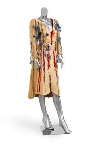 Brighton Historical Society
Clothing - Dress, c. 1974
This dress was worn by Brighton's first female mayor, Councillor Di Lopez, to a Mayoral Ball held at Brighton Technical School in 1977. Diane Margaret Lewis completed a law degree at the University of Melbourne, later marrying one of her classmates, criminal lawyer Ramon (Ray) Lopez. When she decided to run for the Brighton City Council in 1975, she was seen as an outside chance. Undeterred, she rallied a small group of friends and supporters and set out on an extensive door-knocking campaign that won voters to her side and successfully unseated former mayor Keith Devenport. She went on to serve two terms on council from 1975 to 1981. Di initiated many local projects, including the creation of a bike path along Nepean Highway and the first Brighton Festival, while balancing family life and a demanding ‘day job’ as personal assistant to Victorian Minister for Youth, Sport and Recreation Brian Dixon. She was a member of the Women’s Electoral Lobby and a champion for women’s representation, encouraging both Sally Allmand and Kate Harman to run for council (both were successfully elected). She advocated forcefully for an open, transparent local government in which ratepayers had the chance to participate and be heard. In 1976 Di became the first woman to hold the title of Mayor of Brighton, and she made it clear from the outset that she was going to do it her way. For the annual mayoral ball in 1977, ordinarily a staid traditional function, she chose a discotheque theme based on the Rod Stewart album Night on the Town, with a broad dress code of ‘black tie or jeans’: ‘You’ve got to get with the times,’ she said. ‘We want people to wear whatever they feel comfortable in.’ Di herself chose to attend in this knee-length chamois dress embellished with strings, ribbons, beads and feathers. It was both a fashion statement, exemplifying her colourful, flamboyant and forthright style, and a political one: a declaration of her intention to lead a progressive council, embracing the new and refusing to be hemmed in by dated traditions. In 2020 she was awarded an Order of Australia Medal for her service to local government and to the community of Brighton.This dress has local historical significance for its association with Brighton's first female mayor, Councillor Di Lopez, who wore it to a Mayoral Ball in 1976. The dress exemplifies her flamboyant reputation, modern outlook and willingness to break norms. At the time, the dress was a radical choice for a Mayoral Ball, where women typically wore formal evening gowns. With her choice of dress, Cr Lopez was making a public statement, breaking away from dated traditions and announcing her intention to bring the Mayor's office into the 1970s. In this way, the dress also points to the wider social and political changes taking place both in Brighton and across Australia during the mid-1970s.Three quarter length chamois dress circa 1974. Machine stitched with a v-neck and full length sleeves and an uneven raw hem, the dress is decorated with narrow thongs of chamois embellished with red beads and blue feathers. The open-fronted bodice is laced with red ribbon and the skirt is decorated with a large blue wool cross stitch and a combination of blue wool and purple ribbon cross stitch. Made in the style of an Indian 'Wild West Dress'.di lopez, chamois, brighton, brighton council, brighton technical school, mayoral ball, 1970s, feminism -
 Bendigo Military Museum
Photograph - Detachment - Army Survey Regiment, Bonegilla, Victoria, c1973
This is a set of six photographs of personnel from the Detachment - Army Survey Regiment taken in front of its main map production building at Bonegilla, Victoria in c1973. This cartographic map production sub-unit of the Army Survey Regiment operated in buildings owned by the School of Military Survey from 17th of June 1970 to the 30th of September 1985. A total of 800 topographic maps ranging in scale from 1:25,000 to 1: 250,000 scale were completed. A major focus of production in the 1970s was the cartographic completion of the Papua-New Guinea 1:100,000 map series and the Flexiflow quality control system was developed as a tool to coordinate production. The Flexiflow system comprised a series of job plans and charts linked to a task allocation to resource magnetic planning board. Using critical path analysis and task prioritisation, complex job planning was efficiently scheduled, and re-prioritisations readily made. Reproduction requirements were effectively coordinated by way of weekly courier to the Army Survey Regiment at Bendigo. Supervisors and technicians fully embraced the system as they could understand their role, others around them and the positive production achievements. WO1 Bill Boyd (who does not appear in this photograph) was the technical warrant officer for 11 years at the Detachment was awarded the OAM, the Order of Australia Medal for leading the development and the implementation of the Flexiflow system. By mid-1982, production of maps at these scales was undertaken digitally on Bendigo’s AUTOMAP 2 system and the Detachment reverted to production of small-scale large format RAAF aeronautical charts. Detachment personnel managed to produce 18 charts in the following two years, which was an impressive achievement for the staff, given major differences in format, specification and scales. Development of digital production of aeronautical charts in 1984-85 led to gradual reduction in production output and contracting out production was instigated to meet the shortfall and as a consequence the Detachment closed in September 1985. See pages 177 to 180 of Valerie Lovejoy’s book 'Mapmakers of Fortuna – A history of the Army Survey Regiment’ ISBN: 0-646-42120-4. for more information on the history of the Detachment at Bonegilla.This is a set of six photographs of the Detachment - Army Survey Regiment taken in front of the main map production building at Bonegilla, Victoria in c1973. The photographs were printed on photographic paper and are part of the Army Survey Regiment’s Collection. The photographic print and proofs were scanned at 600 dpi. .1) to .3) - Photo, black & white c1973. Back Row L to R: Peter Simpson, Chris Edwards, unidentified (x2), Colin Harden, Rowan Gillies, Bob Rowley OAM, Steve Hansen, Stu Thaxter. Centre Row L to R: Kevin Boehm, Dennis McCarthy, Peter Cross, unidentified, Brian Ryan, unidentified, Ian Marner, unidentified, Phil Smalley. Front Row L to R: Geoff Haynes, Bruce Wetzig, Dave Thompson, unidentified, OC Bob Roche, Ike Lever, John McCulloch, Dick Barwald, unidentified. .4) - Photo, black & white c1973. Back Row L to R: Peter Simpson, Chris Edwards, unidentified (x2), Colin Harden, Rowan Gillies, Bob Rowley OAM, Steve Hansen, Stu Thaxter. Centre Row L to R: Kevin Boehm, Dennis McCarthy, Peter Cross, unidentified, Brian Ryan, unidentified, Ian Marner, Phil Smalley, unidentified, Dick Barwald. Front Row L to R: Geoff Haynes, Bruce Wetzig, Dave Thompson, unidentified, OC Bob Roche, Ike Lever, John McCulloch, unidentified (x2). .5) - Photo, black & white c1973. Back Row L to R: Geoff Haynes, unidentified, John McCulloch, Bruce Wetzig. Front Row L to R: Dave Thompson, Ike Lever, unidentified. .6) - Photo, black & white c1973. L to R: OC Bob Roche, unidentified.There are no personnel annotated.royal australian survey corps, rasvy, army survey regiment, detachment - army survey regiment, army svy regt, asr -
 Bendigo Historical Society Inc.
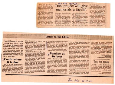
Document - Amy Huxtable Memorial Committee - Newspaper Articles and letters to the Bendigo Art Gallery, 1985 - 1988
Amy Huxtable was born at Cheltenham in 1918, to Robert Henry Huxtable and Violet A Dagg. Her father was an installer for an oil company and travelled the State. taking his family with him. She completed her education at the Bendigo High School and later attended the Bendigo Business College, becoming an expert shorthand writer. Her first position was as a copy writer with Radio 3BO, in the mid 1930s. She worked with an advertising agency in Melbourne and then with the Age,newspaper. In 1953, Miss Huxtable was appointed temporarily to succeed Miss E B Millane as social editress of the Bendigo Advertiser, during the latter's absence abroad. In 1956, Amy travelled abroad and on her return in 1957 was appointed permanently as Women's editor, a position she held for twenty-three ears. During her early years with The Advertiser she wrote under the name Toora, but in later years her own name became widely known. Miss Huxtable was well known both in her professional capacity and through a interest and involvement in community activites. She was life governor of the Bendigo Hospital, the Bendigo Home for the Aged, and Mirridong Home for the Blind, she was a member of Soroptimist International and the Business and Professional Women's Club. Amy was also a tireless worker for the spastic society and a strong supporter of the YWCA. When Amy Huxtable died at Mt AJvernia Hospital on 16 January 1980 Mayor Campbell ordered the city flag to be flown at half-mast. "Lowering the flag is the least we can do for such a lady" Cr Campbell said. Douglas Lockwood, editor of the Bendigo Advertiser said, "She was a devot d colleague who gave her craft and her newspaper the kind of service which identified a rare and generous spirit." She was a true professional who decided to make Bendigo her home. More than 300 people packed St Paul's Church for her funeral ervice the bell tolled as the casket was carried from the church. At a ceremony in the Conservatory Gardens on No ember 22 1981 The Amy Huxtable Memorial Committee presented to the City of Bendigo, a garden seat in memory of the late Miss Huxtable. This Bendigo manufactured seat was a fitting tribute to one ofBendigo's most loved and esteemed citizens. All Miss Huxtable's Advertiser articles were microfilmed and presented to the Library by the above committee. Amy Huxtable Memorial Committee - Newspaper Articles and letters to the Bendigo Art Gallery 2808.9a First Article: Bendigo Advertiser article 18/12/1985 on "two of Bendigo's noted daughters , Ola Cohn and Amy Huxtable" Describes the restoration of the Ola Cohn drinking fountain in Rosalind Park, and the installation of the Amy Huxtable Memorial Seat in the Conservatory Gardens. Second Article: Bendigo Advertiser Letters to the Editor Column 30/12/1988 paragraph entitled "Credit where it is due: "A special tricentennial council effort would be to restore the paths, kerbs and sculpture by Ola Cohn, J H Curnow Fountain, the Bob Brothers Memorial and the Chain of Ponds" (Rosalind Park) 2808.9b Seven Pages of letters: 1. To Mrs Thelma Dingle from Doug Hall, Bendigo Art Gallery Director 30/1/1986 regards the Amy Huxtable committee funding the restoration of the Ola Cohn Fountain by sculptor Mr Marc Clark. 2. From the Amy Huxtable Committee 24/3/1986 back to the Art Gallery explaining that the committee leftover funds be given to the art Gallery to go towards the restoration of the Oal Cohn Fountain. 3. From the Art Gallery to Miss N D young, Amy Huxtable Committee 3/4/1986 thanking the committee for the funds. 4. From the committee to the Mayor and Councillors, Bendigo City, 4/2/1987 asking for an update on the project. 5. Copy of above letter. 6. From the City of Bendigo to the Committee 17/2/1987, advising of progress on the restoration of the fountain. 7. From Norma Young to the Bendigo Advertiser Letters to the Editor, advising of progress on the Ola Cohn Sculpture and the J H Curnow Fountain restoration. history, amy huxtable, bendigo, amy huxtable memorial committee, bendigo conservatory gardens, ola cohn, j h curnow fountain -
 Royal District Nursing Service (now known as Bolton Clarke)
Photograph - Photograph, black and white:, c.1960
This photograph was taken just a few years after the District division of the 'Melbourne District Nursing Society and After Care Hospital' separated in 1957. The District Division then became known as 'Melbourne District Nursing Service'. They moved into their Headquarters at 452 St. Kilda Road, Melbourne which was used as the Nurses Home as well as for Administrative purposes. The Sisters left from there each day to do their rounds and returned to do their book work before retiring at the end of the day. This photograph depicts the winter uniform worn at this time; a grey felt beret which had a red Maltese cross attached in the centre; a grey cotton frock and red cardigan, and a grey woolen coat, some with a grey belt, worn over their uniform.In 1885, 50 years after Melbourne was founded, it was recognized that nursing care was needed for the sick poor in inner Melbourne. The Melbourne District Nursing Society (MDNS), the first Society of its kind in Australia, was founded in February 1885 with one Trained nurse (Nurse), and a second employed six months later, working in the now CBD ie. from Spencer Street to Spring Street and from Victoria Parade to Flinders Street. From its inception the Society was at the forefront of health care. They provided high quality trained nursing care; educated their patients in the curing and prevention of disease; teaching the importance of cleanliness and good nutrition, both by verbal instruction and demonstration, even supplying soup and milk when needed. At that time they walked the streets and lane ways amid the slums of inner Melbourne carrying their nursing bag containing lotion and dressings, and supplying equipment on loan, such as feeding mugs, bedpans, air-cushions, splints, bed cradles feeding mugs and providing clean bed linen and nightdresses as necessary. Trained midwives began home births in August 1893 taking midwifery bundles and providing clothes for the babe and mother as needed. The Society were pioneers in recognizing the need for premises where patients too ill to be in their own home, but not ill enough to go to hospital, was needed, and the Society built, then opened, the After-Care Home, (later called After-Care Hospital), in 1926, for their patients, and patients from Hospitals. Many children were nursed there, some long term during the Polio epidemic; the Society employed two School Teachers. The Society now ran two divisions, the After-Care with its own Trained nurses (Sisters) and nurses and the District division. The Society were the first in Melbourne, in early 1928, to recognize some patients leaving the After-Care, and many at home, needed further social care and they set up ‘Almoners’ from their Committee to visit these patients and be intermediaries in getting them social assistance. It was late the following year before the first training of Almoners took place in Melbourne. In 1930 the Society employed a full time kindergarten teacher to visit poor children in their homes. That year the Society were pioneers in opening an Ante-Natal Clinic at the After-Care, setting a high standard with equipment, keeping records and providing leaflets with instructions in how to keep healthy during pregnancy, what complications to look for and what to do when labour commenced. In 1934 the Society were pioneers again when they opened the first Women’s Welfare Clinic in Melbourne giving advice on birth-control, at first attended by their own patients, but then accepting patients from public hospitals until their own clinics were opened. A Social Service Officer was employed at the After-Care who successfully gained better housing from the Housing Commission for families living under unsuitable conditions. In 1957 the Hospital and Charities Commission decided to take over the After-Care Hospital, so the 'Melbourne District Nursing Society and After-Care Hospital' separated and the 'Melbourne District Nursing Service' was formed, setting up Headquarters at 452 St. Kilda Road. Royal patronage was granted in 1966, now becoming the Royal District Nursing Service, (RDNS). Liaison with public hospitals began with a District nurse attached to a hospital visiting patients before going home. Education continued to be at the forefront of District with research by RDNS Educators and programs being implemented. Initial visits not only assessed the specific nursing situation but the situation as a whole. Their patients ranged in age from babes, children, adults to the elderly and referrals were taken from Hospitals, General Practitioners and allied Health facilities. Some of the care the Sisters provided is as follows: – Post-Natal care given to mother and babe, Wound Care following various types of surgery, accidents, burns, cancer, leg ulcers etc. Supervising and teaching Diabetic Care, including teaching and supervising people with Diabetes to administer their own Insulin, and administering Insulin to those unable to give their own injections. Administering other injections and setting up weekly medication boxes. The Sisters performed Catheterizations on adults suffering from conditions such as Quadriplegia, Paraplegia, Multiple Sclerosis (MS), Motor Neurone Disease (MND) and Guillan-Barre Syndrome, and when required at school on children for e.g. those with Spina Bifida. The Sisters visited those requiring Cystic Fibrosis support and care; those requiring Haemo-Oncology care, including visiting children at school; those requiring Home Enteral Feeding care, and those requiring IV therapy at home and home Dialysis. Palliative Care was given including pain relief with the use of syringe drivers, personal care as needed, and advice and support to both patient and family. The Sisters provided Stoma management to those needing Urostomy, Ileostomy and Colostomy care and those requiring Continence care. HIV/AIDS nursing care was provided; visits to Homeless Persons were made. Personal care was given to patients ranging in age and with varying mobility problems, such as Amputees, those with MS, MND, Guillan-Barre Syndrome, Poliomyelitis, Quadriplegia, Paraplegia, Acquired Brain Injury, to those following a Cerebrovascular Accident (Stroke), those with severe Arthritis and those with a form of Dementia. When necessary the elderly were assisted with personal care and advice given on safety factors with the use of hand rails, bath or shower seats, and hand showers. Rehabilitation with an aim towards independence remained at the forefront of the Sister’s minds and when possible using aids and instruction on safe techniques enabled the person to become fully independent. All care included giving advice and support to the patient and their Carers. The Sisters liaised with the persons Doctor, Hospital and allied Health personal when necessary.Black and White photograph of seven (some partly hidden) Melbourne District Nursing Service (MDNS) Sisters wearing full winter uniform of grey berets and grey long coats, with lapels, over their uniform which is partly seen on one Sister. Some are on a path, and others walking to the open metal gate; one Sister is between two tall, square, dark grey concrete columns. Looking at the photograph, two Sisters have turned left onto the footpath. These two Sisters are carrying oblong leather type bags in their left hand and the Sister between the columns is carrying a white soft material type bag. The Sisters seen have short dark hair under their berets. White plaques with the black numbers '452' are attached to the top 1/3 of each column and an arched grey concrete fence with brick top runs to the left. Behind this are two medium size leafless trees. A metal spiked fence runs from the column to the right of the photograph. Attached to this, near the column, is a white plaque with 'Melbourne District Nursing Service Headquarters' written in black. In the rear is a light grey two story Italian style building with a polygon shaped bay window to the left on the ground floor. It has a long window in the front and another on the side. To the right of this is a veranda with two concrete arches, separated by a roman column. A door can be seen behind the first arch. Above the bay window on the second story are three long arched windows, and to the right of that an arched opening with a roman column separating the partially seen next window. A concrete balustrade is seen at the front of the second story.melbourne district nursing service, headquarters, mdns, nurses, nurses uniforms, royal district nursing service, rdns -
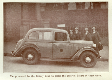 Royal District Nursing Service (now known as Bolton Clarke)
Photograph - Digital image, 07.05.1937
This sepia digital image shows the Austin car which was donated to the Melbourne District Nursing Society (MDNS) in !937 by the Rotary Club of Victoria. It was used by the Matron of the MDNS District Division to visit patients weekly. The photograph is taken outside the MDNS Headquarters at 39 Victoria Parade, Collingwood. The photograph appeared along with an article in The Age Friday May 7, 1937. The photograph appeared in the MDNS Annual Report of 1937. On page 8, mention is made of J.D Johnston Esq, President of the Rotary Club of Victoria, presenting the Austin vehicle to MDNS. Royal District Nursing Service (RDNS) has had various modes of transport over the last 130 plus years. At first, from 1885 as Melbourne District Nursing Society (MDNS), their Trained nurses (Nurses) walked the streets and lane ways amid the slums of central Melbourne. As the Society expanded public transport was used, and bicycles were bought by the Society in 1903 and used in inner areas until 1945. During the Spanish flu epidemic, in 1919, MDNS appealed for assistance to procure Motor vehicles so the Nurses could visit an influx of cases. Through trusts, grants and donations four 'Ford T Model' cars were procured which enabled the Nurses to triple their visits. Through constant use the cars were in such a poor state two were sold in 1922 and the others later. In 1922-23 three Peugeot cars were purchased and a woman Chauffeur, 'Miss Sword', was employed who lived in the Home and was also in charge of the garage. MDNS was expanding and a Motor Auxiliary was formed in 1929 to take the Trained nurses (Sisters) to patients, and some Sisters used their own cars; even a motorcycle was used by one Sister in 1933. All these forms of transport were intermingled and in the early 1950s, and now as Melbourne District Nursing Service, seven Ford Prefect cars were bought followed by twelve Ford Anglia cars 1955. Having received Royal patronage; the now Royal District Nursing Service (RDNS) had its own fleet of Holden vehicles by the mid 1960s and the Motor Auxiliary ceased operating in 1971 as by then all staff employed were required to have a driving licence. Seat-belts had been introduced to Victoria in 1959 and District fitted them to their cars from 1962, even though they did not become compulsory until 1970. The Holden vehicles were replaced with grey Holden Torana vehicles. After several years the fleet was changed to white Toyota Corolla vehicles. The Melways Directory of maps was introduced in 1966, which was a boon to the Sisters, though it was a few years before it went beyond Seville, so a large paper map was used by the Sisters visiting patients in the areas passed Seville. By 2009 there were 598 cars in the fleet and the Sisters travelled 9 million 200,000 kilometres – this is equivalent to 12 trips to the moon and back. In the foreground of this sepia photograph is a side-on view of a four door 1937 style small grey car with a nose shaped bonnet, parked on the road beside the kerb with the headlight facing to the right of the photograph.The bonnet joins onto a straight windscreen which adjoins a slightly curved hood running back along the car. This adjoins a back window which joins onto the sloping rear body of the car with a small protruding boot. Windows are seen above the body work of both facing doors and a smaller sloping window above the body work and rear wheel arch. On the drivers door is a Maltese cross and the words "Melbourne District" written above the Maltese cross and "Nursing Society" below it. In front of this door the body work forms a wheel arch and the headlight is attached between this body work and the bonnet. Rubber tyred wheels with solid hub caps are seen below each wheel arch. On the footpath, behind the bonnet of the car, four Melbourne District Nursing Society (MDNS) Trained nurses (Sisters) are standing. They are wearing dark grey coats over their grey uniforms with white collars, and brimmed grey hats with a Maltese cross on the light coloured headband. The Sister on the right has her left hand gripping the handle on top of her oblong nursing case. A metal spiked fence is behind the Sisters, which runs to the left into one of the two square concrete columns which sit either side of a path. A hedge is behind the fence, and behind this part of a building with three arched windows can be seen. A white plaque is attached to the fence near one of the columns.mdns, melbourne district nursing society, rotary club of victoria, mdns transport, rdns, royal district nursing service, rdns transport