Showing 1230 items matching "sons and co."
-
 Ballarat Clarendon College
Book, The school across the road
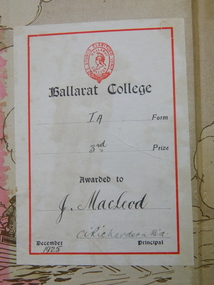
John Anning MacLeod John was born in Ballarat as the second generation of Ballarat MacLeod’s, with his grandfather arriving in Geelong on the Hornet in 1857 as an 11 year old child with his 60 year old father John and mother Mary aged 37 years and 5 brothers and one sister. He grew up on the corner of Drummond Street and Mair Streets, opposite what became St John of God hospital, at his parents house of Dunvegan. John entered Ballarat College as a junior student in 1923. He received 3rd in Form prizes in both 1924 and 1925. His sister Margaret, attended Clarendon Ladies College. The household employed a chauffeur, a cook, a gardener and a ladies maid to care for them. In the 1930’s his father lost his fortune in the collapse of the jute future’s market so the staff were dismissed and he left Ballarat to go to Geelong College as a boarder. He was an officer in the Geelong College cadet corps and joined the Army as a private and rose to the permanent rank of Major after meritorious performance in the intelligence area of operations. He served in North Africa, in Palestine, Egypt, Moratai, the Philippines, Java and New Guinea. He was awarded his Military MBE by King George VI for exceptional devotion to duty and for brilliant coordination work amongst the allied intelligence team. During the war he met Mary Monica Carrol Bateman, a lietenant in the 2/4th Army General Hospital at a dinner party in Brisbane. The couple had four children, Hamish John Torquil born in 1945, Rory Hugh Alexander born in 1947 and twins Ian Donald and Katriona Margaret born in 1948. After the Second World War he worked for Lumley’s Insurance Brokers in London for a couple of years to follow up his accountancy training and then returned to Ballarat due to his father’s failing health and took over the management of John MacLeod and Co, Wholesale grocers and Merchants in Lydiard Street, Ballarat. The business had been started by his great grandfather and they produced the famous Sirdar brand of products and a special tea blend called Afternoon Cup. There was a spice mill in nearby Market Street and there they roasted peanuts, coffee and ground spices for packaging and distribution to the small corner shops who were the mainstay of commercial grocery. In the 1950’s John MacLeod and Co merged with James McKay and Sons to form McKay MacLeod Pty Ltd., wholesale tobacco, wine and spirits and grocery merchants who also manufactured the Sunny South brand of sweet mustard pickles, brewed vinegar and tomato sauce. He introduced the semi-automated system for extensions and financial records on the Bradma plates that saved staff the problems of sorting out the calculations for sales tax, miscellaneous charges etc. that greatly sped up the transactions at the checkout points. A new warehouse and office complex was built in Mair Street east up near Humffray Street, with the manufacturing factory on the opposite side of the street. They had a shop in St Arnaud and one in Geelong which was the local wholesaler for supplying to the corner shops of the greater Geelong area. With the development of supermarkets the demise of the corner store began and so the sales profiles began to diminish. He unsuccessfully stood for Liberal Party pre-selection for the seat of Ballarat in 1948 and served on the Liberal state finance and executive team for many years before resigning over the issue of conscripts being sent to Vietnam. He was instrumental in leading a group of Ballarat academics in opposition to the Vietnam war and publicly resigned from the Liberal Party over their foreign policy. John MacLeod saw the writing on the wall of the business in the early 1970’s and suggested that the firm restructured with focusing on tobacco, wine and spirits. His partners did not agree and so he sold out and retired to Barwon Heads. After a few years of golfing and surfing he became frustrated and joined SCORE, the Service Corp of Retired Executives. In this role he worked for ten years in the Geelong area solving accounting problems for Geelong small businesses and so helped Beaumont’s bakery back onto its feet. He worked gentlemen’s hours of 10 am to 3 pm which allowed him to have time for a round of 9 holes on the golf course at the end of the day and to have a surf before breakfast. He fully retired at the age of 65 and had ten years of voluminous reading of local library books before dying of burns at the age of 75. His war record has been documented in other archives at the College. He was a member of the Naval and Military Club and of the Barwon Heads Golf Club. He had good crafting skills and built a series of steam driven boats for his four children that used to be sailed at home on Lake Wendouree, Lake Learmonth and on the sheltered waters of the Barwon River. The boats are now being restored to operational order to be sailed by his great grandson Grayson Girardi. john-macleod, ballarat-college, 1925, book-prize -
 Flagstaff Hill Maritime Museum and Village
Photograph, early 1900's
This photograph of the 10 crew of the SPECULANT would have been taken prior to Feb 10th 1911, when the ship was wrecked on the south coast of Victoria at a place called Cape Patton. The barquentine SPECULANT was a steel, three-masted sailing ship built in 1895 in Inverkeithing, Scotland, registered in Warrnambool, Victoria and wrecked at Cape Paton, Victoria, 10th February 1911. The SPECULANT had been involved in the timber trade between the United Kingdom and Russia, until sold to its Warrnambool owners and timber merchants Messrs. P.J. McGennan & Co. (Peter John McGennan) in 1902 for 3000 pounds and had her sailed to Warrnambool as her new port. Peter John McGennan was born in 1844 and worked as a builder and cooper in Holyhead, Anglesea, Wales. He immigrated to Australia in 1869 as a free settler and arrived in Warrnambool in 1871 and undertook management of a property in Grassmere for Mr. Palmer. Peter met his wife Emily in South Melbourne and they married in 1873. They had ten children including Harry who lived to 1965, and Andrew who lived until 1958. (The other children were their four brothers - John who was killed in the Dardenalles aged 35, Frederick who died aged 8, Peter who died aged 28, Frank who died aged 5 weeks - and four sisters - Beatrice who died age 89, Edith who died aged 49, Blanche who died aged 89 and Eveline who died aged 48.) In 1874 Peter starting a boating establishment on the Hopkins River. In 1875 he opened up a Coopers business in Kepler Street next to what was Bateman, Smith and Co., moving to Liebig Street, next to the Victoria Hotel, in 1877. In 1882 he then moved to Lava Street (which in later years was the site of Chandlers Hardware Store). He was associated with the establishment of the Butter Factory at Allansford. He started making Butter Boxes to his own design and cheese batts for the Butter Factory. In 1896 established a Box Factory in Davis Street Merrivale, employing 24 people at its peak, (it was burnt down in 1923); and in Pertobe Road from 1912 (now the Army Barracks building). Peter was a Borough Councillor for Albert Ward from 1885 to 1891, he commenced the Foreshore Trust (including the camping grounds along Pertobe Road), and he was an inaugural Director of the Woollen Mill in Harris Street, buying an extensive share-holding in 1908 from the share trader Edward Vidler. They lobbied the Town Hall to have a formal ‘Cutting’ for the waters of the Merri River to be redirected from its natural opening south of Dennington, to its existing opening near Viaduct Road, in order to have the scourings from the wool at the Woollen Mill discharged into the sea. He sold Butter Boxes around the state, and had to ship them to Melbourne by rail. Peter’s purchase of the SPECULANT in 1902 enabled him to back-load white pine from Kaipara, New Zealand to Warrnambool to make his butter boxes then, to gain profitability, buy and ship potatoes and other primary produce bound to Melbourne. (McGennan & Co. had also owned the LA BELLA, which had traded in timber as well, until she was tragically wrecked with the loss of seven lives, after missing the entrance channel to Warrnambool harbour in 1905. It appears that the SPECULANT was bought to replace the LA BELLA.) In 1911 the SPECULANT had been attempting to depart Warrnambool for almost the entire month of January to undergo docking and overhaul in Melbourne. A month of east and south-easterly winds had forced her to remain sheltered in Lady Bay, Warrnambool apart from one morning of northerlies, when an attempt was made to round Cape Otway; she had to return to shelter in Portland after failing to make any headway. With only 140 tons of sand ballast aboard, the ship would not have been easy to handle. Captain Jacobsen and his crew of nine, mainly Swedes, decided to make for Melbourne, leaving Portland Harbour on 5th February 1911. By the 9th they had reached Cape Otway, where they encountered a moonless night, constant heavy rain, and a heavy sea with a south-easterly wind blowing. After safely rounding Cape Otway the course was changed to east, then north-east to take the vessel to a point six miles off Cape Patton, following the orders of Captain Jacobsen, who told the crew to be very careful with the steering, as the wind and sea was running to leeward. The patent log (used to measure speed) had been out of order for the last four months as no-one in Warrnambool was able to fix it: it was intended to have it repaired in Melbourne. In the meantime the crew measured the vessel's speed by looking over the side and estimating wind strength. This compounded the difficulties of imprecise positioning, as the strong cross wind and sea were acting on the lightly laden vessel to steadily drive it towards the shore. At 3.30am on Friday 10 February 1911 Captain Jacobsen and the first mate were looking over the side of the vessel when they heard the sound of breakers and suddenly struck the rocks. The crew immediately knew they had no chance of getting the SPECULANT off, and attempted to rescue themselves by launching the lifeboat, which was instantly smashed to pieces. One of the crew then volunteered to take a line ashore, and the rest of the crew were all able to drag themselves to shore, some suffering hand lacerations from the rocks. Once ashore they began to walk along the coast towards Lorne, believing it was the nearest settlement. Realising their mistake as dawn broke they returned westwards to Cape Patton, and found a farm belonging to Mr C. Ramsden, who took them in and gave them a change of clothes and food. After resting for a day and returning to the wreck to salvage some of their personal possessions, at 10am on Saturday they set out for Apollo Bay, a voyage that took six hours, sometimes wading through flooded creeks up to their necks. The Age described the wreck as "listed to starboard. All the cabin is gutted and the ballast gone. There is a big rock right through the bottom of her, and there is not the slightest hope of getting her off". A Board of Marine inquiry found that Captain Jacobson was guilty of careless navigation by not taking steps to accurately verify the position of the vessel with respect to Cape Otway when the light was visible and by not setting a safe and proper course with respect to the wind and sea. It suspended his certificate for 6 months and ordered him to pay costs. The location of the wreck site was marked for a long time by two anchors on the shoreline, until in 1970 the larger of the two anchors was recovered by the Underwater Explorers' Club and mounted on the foreshore at Apollo Bay. The bell from the wreck was also donated to the Apollo Bay Surf Lifesaving Club but is recorded to have been stolen. Rusting remains of the wreck can still be found on the shoreline on the southern side of, and directly below Cape Patton. Parts of the SPECULANT site have been buried by rubble from construction and maintenance works to the Great Ocean Road, as well as by naturally occurring landslides. Peter J McGennan passed away in 1920. The Gates in the western wall of the Anglican Church in Henna Street/Koroit St are dedicated to him for his time of community work, which is matched with other prominent Warrnambool citizens; Fletcher Jones, John Younger, J.D.E (Tag) Walter, and Edward Vidler. After Peter J McGennan's death Harry, Andrew and Edith continued to operate the family business until July 11th 1923 when the company was wound up. (Andrew lived in Ryot Street Warrnambool, near Lava Street.) Harry McGennan (Peter and Emily’s son) owned the Criterion Hotel in Kepler Street Warrnambool (now demolished). His son Sid and wife Dot lived in 28 Howard Street (corner of Nelson Street) and Sid managed the Criterion until it was decided by the family to sell, and for he remained Manager for the new owners until he retired. Harry commenced the Foreshore Trust in Warrnambool around 1950. The McGennan Carpark in Pertobe Road is named after Harry and there are Memorial-Stone Gates in his memory. (The Gates were once the original entrance to the carpark but are now the exit.). Peter’s great-grandson, also called Andrew, is a Security Officer in Warrnambool. The Patent Log (also called a Taffrail log) from the SPECULANT, mentioned above, and a number of photographs, are now part of the Collection at Flagstaff Hill Maritime Village. The SPECULANT is historically significant as the largest ship to have been registered in Warrnambool, and is believed to have been the largest barquentine to visit Melbourne. It is evidence of the final days of large commercial sailing vessels involved in the Victorian and New Zealand timber trade. The SPECULANT is listed on the Victorian Heritage Register VHR S626Photograph, black and white. of the 10 crew of the SPECULANT on board the ship holding two 'Speculant Warrnambool' lifebuoys. Taken early 1900's flagstaff hill, warrnambool, shipwrecked-coast, flagstaff-hill, flagstaff-hill-maritime-museum, maritime-museum, shipwreck-coast, flagstaff-hill-maritime-village, warrnambool historical photograph, la bella, speculant, cumming and ellis, international timber trade, p. j. mcgennan and co. warrnambool, peter mcgennan, capt. james jacobsen, warrnambool maritime history, h. pengilley apollo bay -
 Flagstaff Hill Maritime Museum and Village
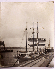
Photograph, early 1900's
This photograph of the SPECULANT was taken while she was in dock at the Warrnambool, Victoria, Breakwater in the early 1900's. Crew seem busy on her decks and others are watching from the breakwater. There are also 2 steamships in the photograph. The barquentine SPECULANT was a steel, three-masted sailing ship built in 1895 in Inverkeithing, Scotland, registered in Warrnambool, Victoria and wrecked at Cape Paton, Victoria, 10th February 1911. The SPECULANT had been involved in the timber trade between the United Kingdom and Russia, until sold to its Warrnambool owners and timber merchants Messrs. P.J. McGennan & Co. (Peter John McGennan) in 1902 for 3000 pounds and had her sailed to Warrnambool as her new port. Peter John McGennan was born in 1844 and worked as a builder and cooper in Holyhead, Anglesea, Wales. He immigrated to Australia in 1869 as a free settler and arrived in Warrnambool in 1871 and undertook management of a property in Grassmere for Mr. Palmer. Peter met his wife Emily in South Melbourne and they married in 1873. They had ten children including Harry who lived to 1965, and Andrew who lived until 1958. (The other children were their four brothers - John who was killed in the Dardenalles aged 35, Frederick who died aged 8, Peter who died aged 28, Frank who died aged 5 weeks - and four sisters - Beatrice who died age 89, Edith who died aged 49, Blanche who died aged 89 and Eveline who died aged 48.) In 1874 Peter starting a boating establishment on the Hopkins River. In 1875 he opened up a Coopers business in Kepler Street next to what was Bateman, Smith and Co., moving to Liebig Street, next to the Victoria Hotel, in 1877. In 1882 he then moved to Lava Street (which in later years was the site of Chandlers Hardware Store). He was associated with the establishment of the Butter Factory at Allansford. He started making Butter Boxes to his own design and cheese batts for the Butter Factory. In 1896 established a Box Factory in Davis Street Merrivale, employing 24 people at its peak, (it was burnt down in 1923); and in Pertobe Road from 1912 (now the Army Barracks building). Peter was a Borough Councillor for Albert Ward from 1885 to 1891, he commenced the Foreshore Trust (including the camping grounds along Pertobe Road), and he was an inaugural Director of the Woollen Mill in Harris Street, buying an extensive share-holding in 1908 from the share trader Edward Vidler. They lobbied the Town Hall to have a formal ‘Cutting’ for the waters of the Merri River to be redirected from its natural opening south of Dennington, to its existing opening near Viaduct Road, in order to have the scourings from the wool at the Woollen Mill discharged into the sea. He sold Butter Boxes around the state, and had to ship them to Melbourne by rail. Peter’s purchase of the SPECULANT in 1902 enabled him to back-load white pine from Kaipara, New Zealand to Warrnambool to make his butter boxes then, to gain profitability, buy and ship potatoes and other primary produce bound to Melbourne. (McGennan & Co. had also owned the LA BELLA, which had traded in timber as well, until she was tragically wrecked with the loss of seven lives, after missing the entrance channel to Warrnambool harbour in 1905. It appears that the SPECULANT was bought to replace the LA BELLA.) In 1911 the SPECULANT had been attempting to depart Warrnambool for almost the entire month of January to undergo docking and overhaul in Melbourne. A month of east and south-easterly winds had forced her to remain sheltered in Lady Bay, Warrnambool apart from one morning of northerlies, when an attempt was made to round Cape Otway; she had to return to shelter in Portland after failing to make any headway. With only 140 tons of sand ballast aboard, the ship would not have been easy to handle. Captain Jacobsen and his crew of nine, mainly Swedes, decided to make for Melbourne, leaving Portland Harbour on 5th February 1911. By the 9th they had reached Cape Otway, where they encountered a moonless night, constant heavy rain, and a heavy sea with a south-easterly wind blowing. After safely rounding Cape Otway the course was changed to east, then north-east to take the vessel to a point six miles off Cape Patton, following the orders of Captain Jacobsen, who told the crew to be very careful with the steering, as the wind and sea was running to leeward. The patent log (used to measure speed) had been out of order for the last four months as no-one in Warrnambool was able to fix it: it was intended to have it repaired in Melbourne. In the meantime the crew measured the vessel's speed by looking over the side and estimating wind strength. This compounded the difficulties of imprecise positioning, as the strong cross wind and sea were acting on the lightly laden vessel to steadily drive it towards the shore. At 3.30am on Friday 10 February 1911 Captain Jacobsen and the first mate were looking over the side of the vessel when they heard the sound of breakers and suddenly struck the rocks. The crew immediately knew they had no chance of getting the SPECULANT off, and attempted to rescue themselves by launching the lifeboat, which was instantly smashed to pieces. One of the crew then volunteered to take a line ashore, and the rest of the crew were all able to drag themselves to shore, some suffering hand lacerations from the rocks. Once ashore they began to walk along the coast towards Lorne, believing it was the nearest settlement. Realising their mistake as dawn broke they returned westwards to Cape Patton, and found a farm belonging to Mr C. Ramsden, who took them in and gave them a change of clothes and food. After resting for a day and returning to the wreck to salvage some of their personal possessions, at 10am on Saturday they set out for Apollo Bay, a voyage that took six hours, sometimes wading through flooded creeks up to their necks. The Age described the wreck as "listed to starboard. All the cabin is gutted and the ballast gone. There is a big rock right through the bottom of her, and there is not the slightest hope of getting her off". A Board of Marine inquiry found that Captain Jacobson was guilty of careless navigation by not taking steps to accurately verify the position of the vessel with respect to Cape Otway when the light was visible and by not setting a safe and proper course with respect to the wind and sea. It suspended his certificate for 6 months and ordered him to pay costs. The location of the wreck site was marked for a long time by two anchors on the shoreline, until in 1970 the larger of the two anchors was recovered by the Underwater Explorers' Club and mounted on the foreshore at Apollo Bay. The bell from the wreck was also donated to the Apollo Bay Surf Lifesaving Club but is recorded to have been stolen. Rusting remains of the wreck can still be found on the shoreline on the southern side of, and directly below Cape Patton. Parts of the SPECULANT site have been buried by rubble from construction and maintenance works to the Great Ocean Road, as well as by naturally occurring landslides. Peter J McGennan passed away in 1920. The Gates in the western wall of the Anglican Church in Henna Street/Koroit St are dedicated to him for his time of community work, which is matched with other prominent Warrnambool citizens; Fletcher Jones, John Younger, J.D.E (Tag) Walter, and Edward Vidler. After Peter J McGennan's death Harry, Andrew and Edith continued to operate the family business until July 11th 1923 when the company was wound up. (Andrew lived in Ryot Street Warrnambool, near Lava Street.) Harry McGennan (Peter and Emily’s son) owned the Criterion Hotel in Kepler Street Warrnambool (now demolished). His son Sid and wife Dot lived in 28 Howard Street (corner of Nelson Street) and Sid managed the Criterion until it was decided by the family to sell, and for he remained Manager for the new owners until he retired. Harry commenced the Foreshore Trust in Warrnambool around 1950. The McGennan Carpark in Pertobe Road is named after Harry and there are Memorial-Stone Gates in his memory. (The Gates were once the original entrance to the carpark but are now the exit.). Peter’s great-grandson, also called Andrew, is a Security Officer in Warrnambool. The Patent Log (also called a Taffrail log) from the SPECULANT, mentioned above, and a number of photographs, are now part of the Collection at Flagstaff Hill Maritime Village. The SPECULANT is historically significant as the largest ship to have been registered in Warrnambool, and is believed to have been the largest barquentine to visit Melbourne. It is evidence of the final days of large commercial sailing vessels involved in the Victorian and New Zealand timber trade. The SPECULANT is listed on the Victorian Heritage Register VHR S626Photograph. black and white, of the three-masted barque SPECULANT in dock at the Warrnambool Breakwater in the early 1900's. A steam ship is docked behind her and another steamship is in Lady Bay on her left. There are people on the SPECULANT and others walking nearby. flagstaff hill, warrnambool, shipwrecked-coast, flagstaff-hill, flagstaff-hill-maritime-museum, maritime-museum, shipwreck-coast, flagstaff-hill-maritime-village, la bella, speculant, cumming and ellis, international timber trade, p. j. mcgennan and co. warrnambool, peter mcgennan, capt. james jacobsen, warrnambool maritime history, h. pengilley apollo bay -
 Flagstaff Hill Maritime Museum and Village
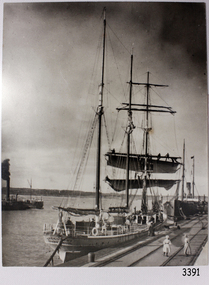
Photograph, before 1911
Photograph, black and white, of the sailing barque Speculant, berth at Warrnambool Breakwater. Two steamships are also in the photograph. There are people on the Speculant and on the breakwater. The barquentine SPECULANT was a steel, three-masted sailing ship built in 1895 in Inverkeithing, Scotland, registered in Warrnambool, Victoria and wrecked at Cape Paton, Victoria, 10th February 1911. The SPECULANT had been involved in the timber trade between the United Kingdom and Russia, until sold to its Warrnambool owners and timber merchants Messrs. P.J. McGennan & Co. (Peter John McGennan) in 1902 for 3000 pounds and had her sailed to Warrnambool as her new port. Peter John McGennan was born in 1844 and worked as a builder and cooper in Holyhead, Anglesea, Wales. He immigrated to Australia in 1869 as a free settler and arrived in Warrnambool in 1871 and undertook management of a property in Grassmere for Mr. Palmer. Peter met his wife Emily in South Melbourne and they married in 1873. They had ten children including Harry who lived to 1965, and Andrew who lived until 1958. (The other children were their four brothers - John who was killed in the Dardenalles aged 35, Frederick who died aged 8, Peter who died aged 28, Frank who died aged 5 weeks - and four sisters - Beatrice who died age 89, Edith who died aged 49, Blanche who died aged 89 and Eveline who died aged 48.) In 1874 Peter starting a boating establishment on the Hopkins River. In 1875 he opened up a Coopers business in Kepler Street next to what was Bateman, Smith and Co., moving to Liebig Street, next to the Victoria Hotel, in 1877. In 1882 he then moved to Lava Street (which in later years was the site of Chandlers Hardware Store). He was associated with the establishment of the Butter Factory at Allansford. He started making Butter Boxes to his own design and cheese batts for the Butter Factory. In 1896 established a Box Factory in Davis Street Merrivale, employing 24 people at its peak, (it was burnt down in 1923); and in Pertobe Road from 1912 (now the Army Barracks building). Peter was a Borough Councillor for Albert Ward from 1885 to 1891, he commenced the Foreshore Trust (including the camping grounds along Pertobe Road), and he was an inaugural Director of the Woollen Mill in Harris Street, buying an extensive share-holding in 1908 from the share trader Edward Vidler. They lobbied the Town Hall to have a formal ‘Cutting’ for the waters of the Merri River to be redirected from its natural opening south of Dennington, to its existing opening near Viaduct Road, in order to have the scourings from the wool at the Woollen Mill discharged into the sea. He sold Butter Boxes around the state, and had to ship them to Melbourne by rail. Peter’s purchase of the SPECULANT in 1902 enabled him to back-load white pine from Kaipara, New Zealand to Warrnambool to make his butter boxes then, to gain profitability, buy and ship potatoes and other primary produce bound to Melbourne. (McGennan & Co. had also owned the LA BELLA, which had traded in timber as well, until she was tragically wrecked with the loss of seven lives, after missing the entrance channel to Warrnambool harbour in 1905. It appears that the SPECULANT was bought to replace the LA BELLA.) In 1911 the SPECULANT had been attempting to depart Warrnambool for almost the entire month of January to undergo docking and overhaul in Melbourne. A month of east and south-easterly winds had forced her to remain sheltered in Lady Bay, Warrnambool apart from one morning of northerlies, when an attempt was made to round Cape Otway; she had to return to shelter in Portland after failing to make any headway. With only 140 tons of sand ballast aboard, the ship would not have been easy to handle. Captain Jacobsen and his crew of nine, mainly Swedes, decided to make for Melbourne, leaving Portland Harbour on 5th February 1911. By the 9th they had reached Cape Otway, where they encountered a moonless night, constant heavy rain, and a heavy sea with a south-easterly wind blowing. After safely rounding Cape Otway the course was changed to east, then north-east to take the vessel to a point six miles off Cape Patton, following the orders of Captain Jacobsen, who told the crew to be very careful with the steering, as the wind and sea was running to leeward. The patent log (used to measure speed) had been out of order for the last four months as no-one in Warrnambool was able to fix it: it was intended to have it repaired in Melbourne. In the meantime the crew measured the vessel's speed by looking over the side and estimating wind strength. This compounded the difficulties of imprecise positioning, as the strong cross wind and sea were acting on the lightly laden vessel to steadily drive it towards the shore. At 3.30am on Friday 10 February 1911 Captain Jacobsen and the first mate were looking over the side of the vessel when they heard the sound of breakers and suddenly struck the rocks. The crew immediately knew they had no chance of getting the SPECULANT off, and attempted to rescue themselves by launching the lifeboat, which was instantly smashed to pieces. One of the crew then volunteered to take a line ashore, and the rest of the crew were all able to drag themselves to shore, some suffering hand lacerations from the rocks. Once ashore they began to walk along the coast towards Lorne, believing it was the nearest settlement. Realising their mistake as dawn broke they returned westwards to Cape Patton, and found a farm belonging to Mr C. Ramsden, who took them in and gave them a change of clothes and food. After resting for a day and returning to the wreck to salvage some of their personal possessions, at 10am on Saturday they set out for Apollo Bay, a voyage that took six hours, sometimes wading through flooded creeks up to their necks. The Age described the wreck as "listed to starboard. All the cabin is gutted and the ballast gone. There is a big rock right through the bottom of her, and there is not the slightest hope of getting her off". A Board of Marine inquiry found that Captain Jacobson was guilty of careless navigation by not taking steps to accurately verify the position of the vessel with respect to Cape Otway when the light was visible and by not setting a safe and proper course with respect to the wind and sea. It suspended his certificate for 6 months and ordered him to pay costs. The location of the wreck site was marked for a long time by two anchors on the shoreline, until in 1970 the larger of the two anchors was recovered by the Underwater Explorers' Club and mounted on the foreshore at Apollo Bay. The bell from the wreck was also donated to the Apollo Bay Surf Lifesaving Club but is recorded to have been stolen. Rusting remains of the wreck can still be found on the shoreline on the southern side of, and directly below Cape Patton. Parts of the SPECULANT site have been buried by rubble from construction and maintenance works to the Great Ocean Road, as well as by naturally occurring landslides. Peter J McGennan passed away in 1920. The Gates in the western wall of the Anglican Church in Henna Street/Koroit St are dedicated to him for his time of community work, which is matched with other prominent Warrnambool citizens; Fletcher Jones, John Younger, J.D.E (Tag) Walter, and Edward Vidler. After Peter J McGennan's death Harry, Andrew and Edith continued to operate the family business until July 11th 1923 when the company was wound up. (Andrew lived in Ryot Street Warrnambool, near Lava Street.) Harry McGennan (Peter and Emily’s son) owned the Criterion Hotel in Kepler Street Warrnambool (now demolished). His son Sid and wife Dot lived in 28 Howard Street (corner of Nelson Street) and Sid managed the Criterion until it was decided by the family to sell, and for he remained Manager for the new owners until he retired. Harry commenced the Foreshore Trust in Warrnambool around 1950. The McGennan Carpark in Pertobe Road is named after Harry and there are Memorial-Stone Gates in his memory. (The Gates were once the original entrance to the carpark but are now the exit.). Peter’s great-grandson, also called Andrew, is a Security Officer in Warrnambool. The Patent Log (also called a Taffrail log) from the SPECULANT, mentioned above, and a number of photographs, are now part of the Collection at Flagstaff Hill Maritime Village. The SPECULANT is historically significant as the largest ship to have been registered in Warrnambool, and is believed to have been the largest barquentine to visit Melbourne. It is evidence of the final days of large commercial sailing vessels involved in the Victorian and New Zealand timber trade. The SPECULANT is listed on the Victorian Heritage Register VHR S626Photograph, black and white, of the sailing barque Speculant, berth at Warrnambool Breakwater. Two steamships are also in the photograph. There are people on the Speculant and on the breakwater.flagstaff hill, warrnambool, shipwrecked-coast, flagstaff-hill, flagstaff-hill-maritime-museum, maritime-museum, shipwreck-coast, flagstaff-hill-maritime-village, warrnambool breakwater, la bella, speculant, cumming and ellis, international timber trade, p. j. mcgennan and co. warrnambool, peter mcgennan, capt. james jacobsen, warrnambool maritime history, h. pengilley apollo bay, cape patton victoria, warrnambool historical photograph -
 Flagstaff Hill Maritime Museum and Village
Photograph, The Barquentine "Speculant" at Melbourne Docks, before 1911
This photograph is of the barque "SPECULANT" during one of her voyages to Melbourne. The barquentine SPECULANT was a steel, three-masted sailing ship built in 1895 in Inverkeithing, Scotland, registered in Warrnambool, Victoria and wrecked at Cape Paton, Victoria, 10th February 1911. The SPECULANT had been involved in the timber trade between the United Kingdom and Russia, until sold to its Warrnambool owners and timber merchants Messrs. P.J. McGennan & Co. (Peter John McGennan) in 1902 for 3000 pounds and had her sailed to Warrnambool as her new port. Peter John McGennan was born in 1844 and worked as a builder and cooper in Holyhead, Anglesea, Wales. He immigrated to Australia in 1869 as a free settler and arrived in Warrnambool in 1871 and undertook management of a property in Grassmere for Mr. Palmer. Peter met his wife Emily in South Melbourne and they married in 1873. They had ten children including Harry who lived to 1965, and Andrew who lived until 1958. (The other children were their four brothers - John who was killed in the Dardenalles aged 35, Frederick who died aged 8, Peter who died aged 28, Frank who died aged 5 weeks - and four sisters - Beatrice who died age 89, Edith who died aged 49, Blanche who died aged 89 and Eveline who died aged 48.) In 1874 Peter starting a boating establishment on the Hopkins River. In 1875 he opened up a Coopers business in Kepler Street next to what was Bateman, Smith and Co., moving to Liebig Street, next to the Victoria Hotel, in 1877. In 1882 he then moved to Lava Street (which in later years was the site of Chandlers Hardware Store). He was associated with the establishment of the Butter Factory at Allansford. He started making Butter Boxes to his own design and cheese batts for the Butter Factory. In 1896 established a Box Factory in Davis Street Merrivale, employing 24 people at its peak, (it was burnt down in 1923); and in Pertobe Road from 1912 (now the Army Barracks building). Peter was a Borough Councillor for Albert Ward from 1885 to 1891, he commenced the Foreshore Trust (including the camping grounds along Pertobe Road), and he was an inaugural Director of the Woollen Mill in Harris Street, buying an extensive share-holding in 1908 from the share trader Edward Vidler. They lobbied the Town Hall to have a formal ‘Cutting’ for the waters of the Merri River to be redirected from its natural opening south of Dennington, to its existing opening near Viaduct Road, in order to have the scourings from the wool at the Woollen Mill discharged into the sea. He sold Butter Boxes around the state, and had to ship them to Melbourne by rail. Peter’s purchase of the SPECULANT in 1902 enabled him to back-load white pine from Kaipara, New Zealand to Warrnambool to make his butter boxes then, to gain profitability, buy and ship potatoes and other primary produce bound to Melbourne. (McGennan & Co. had also owned the LA BELLA, which had traded in timber as well, until she was tragically wrecked with the loss of seven lives, after missing the entrance channel to Warrnambool harbour in 1905. It appears that the SPECULANT was bought to replace the LA BELLA.) In 1911 the SPECULANT had been attempting to depart Warrnambool for almost the entire month of January to undergo docking and overhaul in Melbourne. A month of east and south-easterly winds had forced her to remain sheltered in Lady Bay, Warrnambool apart from one morning of northerlies, when an attempt was made to round Cape Otway; she had to return to shelter in Portland after failing to make any headway. With only 140 tons of sand ballast aboard, the ship would not have been easy to handle. Captain Jacobsen and his crew of nine, mainly Swedes, decided to make for Melbourne, leaving Portland Harbour on 5th February 1911. By the 9th they had reached Cape Otway, where they encountered a moonless night, constant heavy rain, and a heavy sea with a south-easterly wind blowing. After safely rounding Cape Otway the course was changed to east, then north-east to take the vessel to a point six miles off Cape Patton, following the orders of Captain Jacobsen, who told the crew to be very careful with the steering, as the wind and sea was running to leeward. The patent log (used to measure speed) had been out of order for the last four months as no-one in Warrnambool was able to fix it: it was intended to have it repaired in Melbourne. In the meantime the crew measured the vessel's speed by looking over the side and estimating wind strength. This compounded the difficulties of imprecise positioning, as the strong cross wind and sea were acting on the lightly laden vessel to steadily drive it towards the shore. At 3.30am on Friday 10 February 1911 Captain Jacobsen and the first mate were looking over the side of the vessel when they heard the sound of breakers and suddenly struck the rocks. The crew immediately knew they had no chance of getting the SPECULANT off, and attempted to rescue themselves by launching the lifeboat, which was instantly smashed to pieces. One of the crew then volunteered to take a line ashore, and the rest of the crew were all able to drag themselves to shore, some suffering hand lacerations from the rocks. Once ashore they began to walk along the coast towards Lorne, believing it was the nearest settlement. Realising their mistake as dawn broke they returned westwards to Cape Patton, and found a farm belonging to Mr C. Ramsden, who took them in and gave them a change of clothes and food. After resting for a day and returning to the wreck to salvage some of their personal possessions, at 10am on Saturday they set out for Apollo Bay, a voyage that took six hours, sometimes wading through flooded creeks up to their necks. The Age described the wreck as "listed to starboard. All the cabin is gutted and the ballast gone. There is a big rock right through the bottom of her, and there is not the slightest hope of getting her off". A Board of Marine inquiry found that Captain Jacobson was guilty of careless navigation by not taking steps to accurately verify the position of the vessel with respect to Cape Otway when the light was visible and by not setting a safe and proper course with respect to the wind and sea. It suspended his certificate for 6 months and ordered him to pay costs. The location of the wreck site was marked for a long time by two anchors on the shoreline, until in 1970 the larger of the two anchors was recovered by the Underwater Explorers' Club and mounted on the foreshore at Apollo Bay. The bell from the wreck was also donated to the Apollo Bay Surf Lifesaving Club but is recorded to have been stolen. Rusting remains of the wreck can still be found on the shoreline on the southern side of, and directly below Cape Patton. Parts of the SPECULANT site have been buried by rubble from construction and maintenance works to the Great Ocean Road, as well as by naturally occurring landslides. Peter J McGennan passed away in 1920. The Gates in the western wall of the Anglican Church in Henna Street/Koroit St are dedicated to him for his time of community work, which is matched with other prominent Warrnambool citizens; Fletcher Jones, John Younger, J.D.E (Tag) Walter, and Edward Vidler. After Peter J McGennan's death Harry, Andrew and Edith continued to operate the family business until July 11th 1923 when the company was wound up. (Andrew lived in Ryot Street Warrnambool, near Lava Street.) Harry McGennan (Peter and Emily’s son) owned the Criterion Hotel in Kepler Street Warrnambool (now demolished). His son Sid and wife Dot lived in 28 Howard Street (corner of Nelson Street) and Sid managed the Criterion until it was decided by the family to sell, and for he remained Manager for the new owners until he retired. Harry commenced the Foreshore Trust in Warrnambool around 1950. The McGennan Carpark in Pertobe Road is named after Harry and there are Memorial-Stone Gates in his memory. (The Gates were once the original entrance to the carpark but are now the exit.). Peter’s great-grandson, also called Andrew, is a Security Officer in Warrnambool. The Patent Log (also called a Taffrail log) from the SPECULANT, mentioned above, and a number of photographs, are now part of the Collection at Flagstaff Hill Maritime Village. The SPECULANT is historically significant as the largest ship to have been registered in Warrnambool, and is believed to have been the largest barquentine to visit Melbourne. It is evidence of the final days of large commercial sailing vessels involved in the Victorian and New Zealand timber trade. The SPECULANT is listed on the Victorian Heritage Register VHR S626Photograph, black and white, titled "The barquentine "Speculant", at Melbourne Docks"Title below photograph reads "The barquentine "Speculant", at Melbourne Docks"flagstaff hill, warrnambool, shipwrecked-coast, flagstaff-hill, flagstaff-hill-maritime-museum, maritime-museum, shipwreck-coast, flagstaff-hill-maritime-village, photograph, speculant, melbourne docks, cumming and ellis, international timber trade, f. j. mcgennan and co. warrnambool, capt. james jacobsen, warrnambool maritime history -
 Flagstaff Hill Maritime Museum and Village
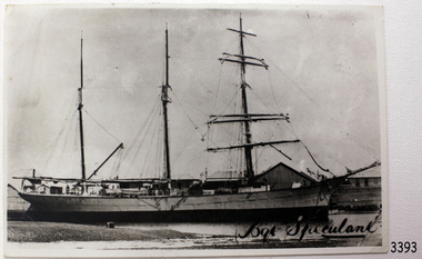
Photograph, before February 1911
Title "Bqt Speculant" on front of photograph - where "Bqt" is the abbreviation for "barguentine" [see The Shipslist, Ancestry.com] The barquentine SPECULANT was a steel, three-masted sailing ship built in 1895 in Inverkeithing, Scotland, registered in Warrnambool, Victoria and wrecked at Cape Paton, Victoria, 10th February 1911. The SPECULANT had been involved in the timber trade between the United Kingdom and Russia, until sold to its Warrnambool owners and timber merchants Messrs. P.J. McGennan & Co. (Peter John McGennan) in 1902 for 3000 pounds and had her sailed to Warrnambool as her new port. Peter John McGennan was born in 1844 and worked as a builder and cooper in Holyhead, Anglesea, Wales. He immigrated to Australia in 1869 as a free settler and arrived in Warrnambool in 1871 and undertook management of a property in Grassmere for Mr. Palmer. Peter met his wife Emily in South Melbourne and they married in 1873. They had ten children including Harry who lived to 1965, and Andrew who lived until 1958. (The other children were their four brothers - John who was killed in the Dardenalles aged 35, Frederick who died aged 8, Peter who died aged 28, Frank who died aged 5 weeks - and four sisters - Beatrice who died age 89, Edith who died aged 49, Blanche who died aged 89 and Eveline who died aged 48.) In 1874 Peter starting a boating establishment on the Hopkins River. In 1875 he opened up a Coopers business in Kepler Street next to what was Bateman, Smith and Co., moving to Liebig Street, next to the Victoria Hotel, in 1877. In 1882 he then moved to Lava Street (which in later years was the site of Chandlers Hardware Store). He was associated with the establishment of the Butter Factory at Allansford. He started making Butter Boxes to his own design and cheese batts for the Butter Factory. In 1896 established a Box Factory in Davis Street Merrivale, employing 24 people at its peak, (it was burnt down in 1923); and in Pertobe Road from 1912 (now the Army Barracks building). Peter was a Borough Councillor for Albert Ward from 1885 to 1891, he commenced the Foreshore Trust (including the camping grounds along Pertobe Road), and he was an inaugural Director of the Woollen Mill in Harris Street, buying an extensive share-holding in 1908 from the share trader Edward Vidler. They lobbied the Town Hall to have a formal ‘Cutting’ for the waters of the Merri River to be redirected from its natural opening south of Dennington, to its existing opening near Viaduct Road, in order to have the scourings from the wool at the Woollen Mill discharged into the sea. He sold Butter Boxes around the state, and had to ship them to Melbourne by rail. Peter’s purchase of the SPECULANT in 1902 enabled him to back-load white pine from Kaipara, New Zealand to Warrnambool to make his butter boxes then, to gain profitability, buy and ship potatoes and other primary produce bound to Melbourne. (McGennan & Co. had also owned the LA BELLA, which had traded in timber as well, until she was tragically wrecked with the loss of seven lives, after missing the entrance channel to Warrnambool harbour in 1905. It appears that the SPECULANT was bought to replace the LA BELLA.) In 1911 the SPECULANT had been attempting to depart Warrnambool for almost the entire month of January to undergo docking and overhaul in Melbourne. A month of east and south-easterly winds had forced her to remain sheltered in Lady Bay, Warrnambool apart from one morning of northerlies, when an attempt was made to round Cape Otway; she had to return to shelter in Portland after failing to make any headway. With only 140 tons of sand ballast aboard, the ship would not have been easy to handle. Captain Jacobsen and his crew of nine, mainly Swedes, decided to make for Melbourne, leaving Portland Harbour on 5th February 1911. By the 9th they had reached Cape Otway, where they encountered a moonless night, constant heavy rain, and a heavy sea with a south-easterly wind blowing. After safely rounding Cape Otway the course was changed to east, then north-east to take the vessel to a point six miles off Cape Patton, following the orders of Captain Jacobsen, who told the crew to be very careful with the steering, as the wind and sea was running to leeward. The patent log (used to measure speed) had been out of order for the last four months as no-one in Warrnambool was able to fix it: it was intended to have it repaired in Melbourne. In the meantime the crew measured the vessel's speed by looking over the side and estimating wind strength. This compounded the difficulties of imprecise positioning, as the strong cross wind and sea were acting on the lightly laden vessel to steadily drive it towards the shore. At 3.30am on Friday 10 February 1911 Captain Jacobsen and the first mate were looking over the side of the vessel when they heard the sound of breakers and suddenly struck the rocks. The crew immediately knew they had no chance of getting the SPECULANT off, and attempted to rescue themselves by launching the lifeboat, which was instantly smashed to pieces. One of the crew then volunteered to take a line ashore, and the rest of the crew were all able to drag themselves to shore, some suffering hand lacerations from the rocks. Once ashore they began to walk along the coast towards Lorne, believing it was the nearest settlement. Realising their mistake as dawn broke they returned westwards to Cape Patton, and found a farm belonging to Mr C. Ramsden, who took them in and gave them a change of clothes and food. After resting for a day and returning to the wreck to salvage some of their personal possessions, at 10am on Saturday they set out for Apollo Bay, a voyage that took six hours, sometimes wading through flooded creeks up to their necks. The Age described the wreck as "listed to starboard. All the cabin is gutted and the ballast gone. There is a big rock right through the bottom of her, and there is not the slightest hope of getting her off". A Board of Marine inquiry found that Captain Jacobson was guilty of careless navigation by not taking steps to accurately verify the position of the vessel with respect to Cape Otway when the light was visible and by not setting a safe and proper course with respect to the wind and sea. It suspended his certificate for 6 months and ordered him to pay costs. The location of the wreck site was marked for a long time by two anchors on the shoreline, until in 1970 the larger of the two anchors was recovered by the Underwater Explorers' Club and mounted on the foreshore at Apollo Bay. The bell from the wreck was also donated to the Apollo Bay Surf Lifesaving Club but is recorded to have been stolen. Rusting remains of the wreck can still be found on the shoreline on the southern side of, and directly below Cape Patton. Parts of the SPECULANT site have been buried by rubble from construction and maintenance works to the Great Ocean Road, as well as by naturally occurring landslides. Peter J McGennan passed away in 1920. The Gates in the western wall of the Anglican Church in Henna Street/Koroit St are dedicated to him for his time of community work, which is matched with other prominent Warrnambool citizens; Fletcher Jones, John Younger, J.D.E (Tag) Walter, and Edward Vidler. After Peter J McGennan's death Harry, Andrew and Edith continued to operate the family business until July 11th 1923 when the company was wound up. (Andrew lived in Ryot Street Warrnambool, near Lava Street.) Harry McGennan (Peter and Emily’s son) owned the Criterion Hotel in Kepler Street Warrnambool (now demolished). His son Sid and wife Dot lived in 28 Howard Street (corner of Nelson Street) and Sid managed the Criterion until it was decided by the family to sell, and for he remained Manager for the new owners until he retired. Harry commenced the Foreshore Trust in Warrnambool around 1950. The McGennan Carpark in Pertobe Road is named after Harry and there are Memorial-Stone Gates in his memory. (The Gates were once the original entrance to the carpark but are now the exit.). Peter’s great-grandson, also called Andrew, is a Security Officer in Warrnambool. The Patent Log (also called a Taffrail log) from the SPECULANT, mentioned above, and a number of photographs, are now part of the Collection at Flagstaff Hill Maritime Village. The SPECULANT is historically significant as the largest ship to have been registered in Warrnambool, and is believed to have been the largest barquentine to visit Melbourne. It is evidence of the final days of large commercial sailing vessels involved in the Victorian and New Zealand timber trade. The SPECULANT is listed on the Victorian Heritage Register VHR S626Back and White photograph of the barquentine Speculant, at dock. Title "Bqt Speculant" on front of photo.Title "Bqt Speculant" on front of photo.flagstaff hill, warrnambool, shipwrecked-coast, flagstaff-hill, flagstaff-hill-maritime-museum, maritime-museum, shipwreck-coast, flagstaff-hill-maritime-village, la bella, speculant, cumming and ellis, international timber trade, p. j. mcgennan and co. warrnambool, peter mcgennan, capt. james jacobsen, warrnambool maritime history, h. pengilley apollo bay, cape patton victoria, warrnambool historical photograph -
 Flagstaff Hill Maritime Museum and Village
Photograph, c 10th February 1911
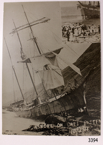
This photograph was taken after the SPECULANT was wrecked at Cape Patton, Victoria. It is uncertain which ship is in the photograph insert to the the top right hand corner of this photograph. The barquentine SPECULANT was a steel, three-masted sailing ship built in 1895 in Inverkeithing, Scotland, registered in Warrnambool, Victoria and wrecked at Cape Paton, Victoria, 10th February 1911. The SPECULANT had been involved in the timber trade between the United Kingdom and Russia, until sold to its Warrnambool owners and timber merchants Messrs. P.J. McGennan & Co. (Peter John McGennan) in 1902 for 3000 pounds and had her sailed to Warrnambool as her new port. Peter John McGennan was born in 1844 and worked as a builder and cooper in Holyhead, Anglesea, Wales. He immigrated to Australia in 1869 as a free settler and arrived in Warrnambool in 1871 and undertook management of a property in Grassmere for Mr. Palmer. Peter met his wife Emily in South Melbourne and they married in 1873. They had ten children including Harry who lived to 1965, and Andrew who lived until 1958. (The other children were their four brothers - John who was killed in the Dardenalles aged 35, Frederick who died aged 8, Peter who died aged 28, Frank who died aged 5 weeks - and four sisters - Beatrice who died age 89, Edith who died aged 49, Blanche who died aged 89 and Eveline who died aged 48.) In 1874 Peter starting a boating establishment on the Hopkins River. In 1875 he opened up a Coopers business in Kepler Street next to what was Bateman, Smith and Co., moving to Liebig Street, next to the Victoria Hotel, in 1877. In 1882 he then moved to Lava Street (which in later years was the site of Chandlers Hardware Store). He was associated with the establishment of the Butter Factory at Allansford. He started making Butter Boxes to his own design and cheese batts for the Butter Factory. In 1896 established a Box Factory in Davis Street Merrivale, employing 24 people at its peak, (it was burnt down in 1923); and in Pertobe Road from 1912 (now the Army Barracks building). Peter was a Borough Councillor for Albert Ward from 1885 to 1891, he commenced the Foreshore Trust (including the camping grounds along Pertobe Road), and he was an inaugural Director of the Woollen Mill in Harris Street, buying an extensive share-holding in 1908 from the share trader Edward Vidler. They lobbied the Town Hall to have a formal ‘Cutting’ for the waters of the Merri River to be redirected from its natural opening south of Dennington, to its existing opening near Viaduct Road, in order to have the scourings from the wool at the Woollen Mill discharged into the sea. He sold Butter Boxes around the state, and had to ship them to Melbourne by rail. Peter’s purchase of the SPECULANT in 1902 enabled him to back-load white pine from Kaipara, New Zealand to Warrnambool to make his butter boxes then, to gain profitability, buy and ship potatoes and other primary produce bound to Melbourne. (McGennan & Co. had also owned the LA BELLA, which had traded in timber as well, until she was tragically wrecked with the loss of seven lives, after missing the entrance channel to Warrnambool harbour in 1905. It appears that the SPECULANT was bought to replace the LA BELLA.) In 1911 the SPECULANT had been attempting to depart Warrnambool for almost the entire month of January to undergo docking and overhaul in Melbourne. A month of east and south-easterly winds had forced her to remain sheltered in Lady Bay, Warrnambool apart from one morning of northerlies, when an attempt was made to round Cape Otway; she had to return to shelter in Portland after failing to make any headway. With only 140 tons of sand ballast aboard, the ship would not have been easy to handle. Captain Jacobsen and his crew of nine, mainly Swedes, decided to make for Melbourne, leaving Portland Harbour on 5th February 1911. By the 9th they had reached Cape Otway, where they encountered a moonless night, constant heavy rain, and a heavy sea with a south-easterly wind blowing. After safely rounding Cape Otway the course was changed to east, then north-east to take the vessel to a point six miles off Cape Patton, following the orders of Captain Jacobsen, who told the crew to be very careful with the steering, as the wind and sea was running to leeward. The patent log (used to measure speed) had been out of order for the last four months as no-one in Warrnambool was able to fix it: it was intended to have it repaired in Melbourne. In the meantime the crew measured the vessel's speed by looking over the side and estimating wind strength. This compounded the difficulties of imprecise positioning, as the strong cross wind and sea were acting on the lightly laden vessel to steadily drive it towards the shore. At 3.30am on Friday 10 February 1911 Captain Jacobsen and the first mate were looking over the side of the vessel when they heard the sound of breakers and suddenly struck the rocks. The crew immediately knew they had no chance of getting the SPECULANT off, and attempted to rescue themselves by launching the lifeboat, which was instantly smashed to pieces. One of the crew then volunteered to take a line ashore, and the rest of the crew were all able to drag themselves to shore, some suffering hand lacerations from the rocks. Once ashore they began to walk along the coast towards Lorne, believing it was the nearest settlement. Realising their mistake as dawn broke they returned westwards to Cape Patton, and found a farm belonging to Mr C. Ramsden, who took them in and gave them a change of clothes and food. After resting for a day and returning to the wreck to salvage some of their personal possessions, at 10am on Saturday they set out for Apollo Bay, a voyage that took six hours, sometimes wading through flooded creeks up to their necks. The Age described the wreck as "listed to starboard. All the cabin is gutted and the ballast gone. There is a big rock right through the bottom of her, and there is not the slightest hope of getting her off". A Board of Marine inquiry found that Captain Jacobson was guilty of careless navigation by not taking steps to accurately verify the position of the vessel with respect to Cape Otway when the light was visible and by not setting a safe and proper course with respect to the wind and sea. It suspended his certificate for 6 months and ordered him to pay costs. The location of the wreck site was marked for a long time by two anchors on the shoreline, until in 1970 the larger of the two anchors was recovered by the Underwater Explorers' Club and mounted on the foreshore at Apollo Bay. The bell from the wreck was also donated to the Apollo Bay Surf Lifesaving Club but is recorded to have been stolen. Rusting remains of the wreck can still be found on the shoreline on the southern side of, and directly below Cape Patton. Parts of the SPECULANT site have been buried by rubble from construction and maintenance works to the Great Ocean Road, as well as by naturally occurring landslides. Peter J McGennan passed away in 1920. The Gates in the western wall of the Anglican Church in Henna Street/Koroit St are dedicated to him for his time of community work, which is matched with other prominent Warrnambool citizens; Fletcher Jones, John Younger, J.D.E (Tag) Walter, and Edward Vidler. After Peter J McGennan's death Harry, Andrew and Edith continued to operate the family business until July 11th 1923 when the company was wound up. (Andrew lived in Ryot Street Warrnambool, near Lava Street.) Harry McGennan (Peter and Emily’s son) owned the Criterion Hotel in Kepler Street Warrnambool (now demolished). His son Sid and wife Dot lived in 28 Howard Street (corner of Nelson Street) and Sid managed the Criterion until it was decided by the family to sell, and for he remained Manager for the new owners until he retired. Harry commenced the Foreshore Trust in Warrnambool around 1950. The McGennan Carpark in Pertobe Road is named after Harry and there are Memorial-Stone Gates in his memory. (The Gates were once the original entrance to the carpark but are now the exit.). Peter’s great-grandson, also called Andrew, is a Security Officer in Warrnambool. The Patent Log (also called a Taffrail log) from the SPECULANT, mentioned above, and a number of photographs, are now part of the Collection at Flagstaff Hill Maritime Village. The SPECULANT is historically significant as the largest ship to have been registered in Warrnambool, and is believed to have been the largest barquentine to visit Melbourne. It is evidence of the final days of large commercial sailing vessels involved in the Victorian and New Zealand timber trade. The SPECULANT is listed on the Victorian Heritage Register VHR S626Black and White photograph of the barquentine Speculant, on rocks at Cape Patton, steep hills in the background. A second photo in top right hand corner of a different ship aground, with a crowd in the foreground, Hand written in white on front of photograph "SPECULANT ASHORE ON CAPE PATTEN 10/2/11" (incorrect spelling of Cape Patton).Hand written in white on front of photograph "SPECULANT ASHORE ON CAPE PATTEN 10/2/11" flagstaff hill, warrnambool, shipwrecked-coast, flagstaff-hill, flagstaff-hill-maritime-museum, maritime-museum, shipwreck-coast, flagstaff-hill-maritime-village, photograph, speculant, cape patton, cumming and ellis, international timber trade, f. j. mcgennan and co. warrnambool, capt. james jacobsen, warrnambool maritime historyla bella, p. j. mcgennan and co. warrnambool, peter mcgennan, warrnambool maritime history, h. pengilley apollo bay, cape patton victoria, warrnambool historical photograph -
 Flagstaff Hill Maritime Museum and Village
Photograph, 10/02/1911
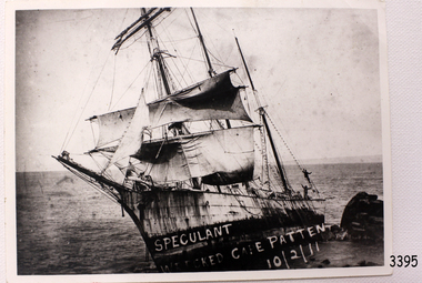
This photograph of the wrecked SPECULANT would have been taken soon after the ship ran aground, as her sails are still flying. There are people aboard at the stern of the ship. The barquentine SPECULANT was a steel, three-masted sailing ship built in 1895 in Inverkeithing, Scotland, registered in Warrnambool, Victoria and wrecked at Cape Paton, Victoria, 10th February 1911. The SPECULANT had been involved in the timber trade between the United Kingdom and Russia, until sold to its Warrnambool owners and timber merchants Messrs. P.J. McGennan & Co. (Peter John McGennan) in 1902 for 3000 pounds and had her sailed to Warrnambool as her new port. Peter John McGennan was born in 1844 and worked as a builder and cooper in Holyhead, Anglesea, Wales. He immigrated to Australia in 1869 as a free settler and arrived in Warrnambool in 1871 and undertook management of a property in Grassmere for Mr. Palmer. Peter met his wife Emily in South Melbourne and they married in 1873. They had ten children including Harry who lived to 1965, and Andrew who lived until 1958. (The other children were their four brothers - John who was killed in the Dardenalles aged 35, Frederick who died aged 8, Peter who died aged 28, Frank who died aged 5 weeks - and four sisters - Beatrice who died age 89, Edith who died aged 49, Blanche who died aged 89 and Eveline who died aged 48.) In 1874 Peter starting a boating establishment on the Hopkins River. In 1875 he opened up a Coopers business in Kepler Street next to what was Bateman, Smith and Co., moving to Liebig Street, next to the Victoria Hotel, in 1877. In 1882 he then moved to Lava Street (which in later years was the site of Chandlers Hardware Store). He was associated with the establishment of the Butter Factory at Allansford. He started making Butter Boxes to his own design and cheese batts for the Butter Factory. In 1896 established a Box Factory in Davis Street Merrivale, employing 24 people at its peak, (it was burnt down in 1923); and in Pertobe Road from 1912 (now the Army Barracks building). Peter was a Borough Councillor for Albert Ward from 1885 to 1891, he commenced the Foreshore Trust (including the camping grounds along Pertobe Road), and he was an inaugural Director of the Woollen Mill in Harris Street, buying an extensive share-holding in 1908 from the share trader Edward Vidler. They lobbied the Town Hall to have a formal ‘Cutting’ for the waters of the Merri River to be redirected from its natural opening south of Dennington, to its existing opening near Viaduct Road, in order to have the scourings from the wool at the Woollen Mill discharged into the sea. He sold Butter Boxes around the state, and had to ship them to Melbourne by rail. Peter’s purchase of the SPECULANT in 1902 enabled him to back-load white pine from Kaipara, New Zealand to Warrnambool to make his butter boxes then, to gain profitability, buy and ship potatoes and other primary produce bound to Melbourne. (McGennan & Co. had also owned the LA BELLA, which had traded in timber as well, until she was tragically wrecked with the loss of seven lives, after missing the entrance channel to Warrnambool harbour in 1905. It appears that the SPECULANT was bought to replace the LA BELLA.) In 1911 the SPECULANT had been attempting to depart Warrnambool for almost the entire month of January to undergo docking and overhaul in Melbourne. A month of east and south-easterly winds had forced her to remain sheltered in Lady Bay, Warrnambool apart from one morning of northerlies, when an attempt was made to round Cape Otway; she had to return to shelter in Portland after failing to make any headway. With only 140 tons of sand ballast aboard, the ship would not have been easy to handle. Captain Jacobsen and his crew of nine, mainly Swedes, decided to make for Melbourne, leaving Portland Harbour on 5th February 1911. By the 9th they had reached Cape Otway, where they encountered a moonless night, constant heavy rain, and a heavy sea with a south-easterly wind blowing. After safely rounding Cape Otway the course was changed to east, then north-east to take the vessel to a point six miles off Cape Patton, following the orders of Captain Jacobsen, who told the crew to be very careful with the steering, as the wind and sea was running to leeward. The patent log (used to measure speed) had been out of order for the last four months as no-one in Warrnambool was able to fix it: it was intended to have it repaired in Melbourne. In the meantime the crew measured the vessel's speed by looking over the side and estimating wind strength. This compounded the difficulties of imprecise positioning, as the strong cross wind and sea were acting on the lightly laden vessel to steadily drive it towards the shore. At 3.30am on Friday 10 February 1911 Captain Jacobsen and the first mate were looking over the side of the vessel when they heard the sound of breakers and suddenly struck the rocks. The crew immediately knew they had no chance of getting the SPECULANT off, and attempted to rescue themselves by launching the lifeboat, which was instantly smashed to pieces. One of the crew then volunteered to take a line ashore, and the rest of the crew were all able to drag themselves to shore, some suffering hand lacerations from the rocks. Once ashore they began to walk along the coast towards Lorne, believing it was the nearest settlement. Realising their mistake as dawn broke they returned westwards to Cape Patton, and found a farm belonging to Mr C. Ramsden, who took them in and gave them a change of clothes and food. After resting for a day and returning to the wreck to salvage some of their personal possessions, at 10am on Saturday they set out for Apollo Bay, a voyage that took six hours, sometimes wading through flooded creeks up to their necks. The Age described the wreck as "listed to starboard. All the cabin is gutted and the ballast gone. There is a big rock right through the bottom of her, and there is not the slightest hope of getting her off". A Board of Marine inquiry found that Captain Jacobson was guilty of careless navigation by not taking steps to accurately verify the position of the vessel with respect to Cape Otway when the light was visible and by not setting a safe and proper course with respect to the wind and sea. It suspended his certificate for 6 months and ordered him to pay costs. The location of the wreck site was marked for a long time by two anchors on the shoreline, until in 1970 the larger of the two anchors was recovered by the Underwater Explorers' Club and mounted on the foreshore at Apollo Bay. The bell from the wreck was also donated to the Apollo Bay Surf Lifesaving Club but is recorded to have been stolen. Rusting remains of the wreck can still be found on the shoreline on the southern side of, and directly below Cape Patton. Parts of the SPECULANT site have been buried by rubble from construction and maintenance works to the Great Ocean Road, as well as by naturally occurring landslides. Peter J McGennan passed away in 1920. The Gates in the western wall of the Anglican Church in Henna Street/Koroit St are dedicated to him for his time of community work, which is matched with other prominent Warrnambool citizens; Fletcher Jones, John Younger, J.D.E (Tag) Walter, and Edward Vidler. After Peter J McGennan's death Harry, Andrew and Edith continued to operate the family business until July 11th 1923 when the company was wound up. (Andrew lived in Ryot Street Warrnambool, near Lava Street.) Harry McGennan (Peter and Emily’s son) owned the Criterion Hotel in Kepler Street Warrnambool (now demolished). His son Sid and wife Dot lived in 28 Howard Street (corner of Nelson Street) and Sid managed the Criterion until it was decided by the family to sell, and for he remained Manager for the new owners until he retired. Harry commenced the Foreshore Trust in Warrnambool around 1950. The McGennan Carpark in Pertobe Road is named after Harry and there are Memorial-Stone Gates in his memory. (The Gates were once the original entrance to the carpark but are now the exit.). Peter’s great-grandson, also called Andrew, is a Security Officer in Warrnambool. The Patent Log (also called a Taffrail log) from the SPECULANT, mentioned above, and a number of photographs, are now part of the Collection at Flagstaff Hill Maritime Village. The SPECULANT is historically significant as the largest ship to have been registered in Warrnambool, and is believed to have been the largest barquentine to visit Melbourne. It is evidence of the final days of large commercial sailing vessels involved in the Victorian and New Zealand timber trade. The SPECULANT is listed on the Victorian Heritage Register VHR S626Black and White photograph of the barquentine Speculant, on rocks at Cape Patton, some sails still hung, people on board. White hand writing on front of photograph "SPECULANT WRECKED CAPE PATTEN.10/2/11" (incorrect spelling of Cape Patton)White hand writing on front of photograph "SPECULANT WRECKED CAPE PATTEN.10/2/11" flagstaff hill, warrnambool, shipwrecked-coast, flagstaff-hill, flagstaff-hill-maritime-museum, maritime-museum, shipwreck-coast, flagstaff-hill-maritime-village, la bella, speculant, cumming and ellis, international timber trade, p. j. mcgennan and co. warrnambool, peter mcgennan, capt. james jacobsen, warrnambool maritime history, h. pengilley apollo bay, cape patton victoria, warrnambool historical photograph -
 Flagstaff Hill Maritime Museum and Village
Photograph, Mr. H. Pengilley, c. February 1911
This photograph would have been taken a while after the SPECULANT was wrecked at Cape Patton, Victoria, because she has broken up and the bow has been moved away from the ship. The barquentine SPECULANT was a steel, three-masted sailing ship built in 1895 in Inverkeithing, Scotland, registered in Warrnambool, Victoria and wrecked at Cape Paton, Victoria, 10th February 1911. The SPECULANT had been involved in the timber trade between the United Kingdom and Russia, until sold to its Warrnambool owners and timber merchants Messrs. P.J. McGennan & Co. (Peter John McGennan) in 1902 for 3000 pounds and had her sailed to Warrnambool as her new port. Peter John McGennan was born in 1844 and worked as a builder and cooper in Holyhead, Anglesea, Wales. He immigrated to Australia in 1869 as a free settler and arrived in Warrnambool in 1871 and undertook management of a property in Grassmere for Mr. Palmer. Peter met his wife Emily in South Melbourne and they married in 1873. They had ten children including Harry who lived to 1965, and Andrew who lived until 1958. (The other children were their four brothers - John who was killed in the Dardenalles aged 35, Frederick who died aged 8, Peter who died aged 28, Frank who died aged 5 weeks - and four sisters - Beatrice who died age 89, Edith who died aged 49, Blanche who died aged 89 and Eveline who died aged 48.) In 1874 Peter starting a boating establishment on the Hopkins River. In 1875 he opened up a Coopers business in Kepler Street next to what was Bateman, Smith and Co., moving to Liebig Street, next to the Victoria Hotel, in 1877. In 1882 he then moved to Lava Street (which in later years was the site of Chandlers Hardware Store). He was associated with the establishment of the Butter Factory at Allansford. He started making Butter Boxes to his own design and cheese batts for the Butter Factory. In 1896 established a Box Factory in Davis Street Merrivale, employing 24 people at its peak, (it was burnt down in 1923); and in Pertobe Road from 1912 (now the Army Barracks building). Peter was a Borough Councillor for Albert Ward from 1885 to 1891, he commenced the Foreshore Trust (including the camping grounds along Pertobe Road), and he was an inaugural Director of the Woollen Mill in Harris Street, buying an extensive share-holding in 1908 from the share trader Edward Vidler. They lobbied the Town Hall to have a formal ‘Cutting’ for the waters of the Merri River to be redirected from its natural opening south of Dennington, to its existing opening near Viaduct Road, in order to have the scourings from the wool at the Woollen Mill discharged into the sea. He sold Butter Boxes around the state, and had to ship them to Melbourne by rail. Peter’s purchase of the SPECULANT in 1902 enabled him to back-load white pine from Kaipara, New Zealand to Warrnambool to make his butter boxes then, to gain profitability, buy and ship potatoes and other primary produce bound to Melbourne. (McGennan & Co. had also owned the LA BELLA, which had traded in timber as well, until she was tragically wrecked with the loss of seven lives, after missing the entrance channel to Warrnambool harbour in 1905. It appears that the SPECULANT was bought to replace the LA BELLA.) In 1911 the SPECULANT had been attempting to depart Warrnambool for almost the entire month of January to undergo docking and overhaul in Melbourne. A month of east and south-easterly winds had forced her to remain sheltered in Lady Bay, Warrnambool apart from one morning of northerlies, when an attempt was made to round Cape Otway; she had to return to shelter in Portland after failing to make any headway. With only 140 tons of sand ballast aboard, the ship would not have been easy to handle. Captain Jacobsen and his crew of nine, mainly Swedes, decided to make for Melbourne, leaving Portland Harbour on 5th February 1911. By the 9th they had reached Cape Otway, where they encountered a moonless night, constant heavy rain, and a heavy sea with a south-easterly wind blowing. After safely rounding Cape Otway the course was changed to east, then north-east to take the vessel to a point six miles off Cape Patton, following the orders of Captain Jacobsen, who told the crew to be very careful with the steering, as the wind and sea was running to leeward. The patent log (used to measure speed) had been out of order for the last four months as no-one in Warrnambool was able to fix it: it was intended to have it repaired in Melbourne. In the meantime the crew measured the vessel's speed by looking over the side and estimating wind strength. This compounded the difficulties of imprecise positioning, as the strong cross wind and sea were acting on the lightly laden vessel to steadily drive it towards the shore. At 3.30am on Friday 10 February 1911 Captain Jacobsen and the first mate were looking over the side of the vessel when they heard the sound of breakers and suddenly struck the rocks. The crew immediately knew they had no chance of getting the SPECULANT off, and attempted to rescue themselves by launching the lifeboat, which was instantly smashed to pieces. One of the crew then volunteered to take a line ashore, and the rest of the crew were all able to drag themselves to shore, some suffering hand lacerations from the rocks. Once ashore they began to walk along the coast towards Lorne, believing it was the nearest settlement. Realising their mistake as dawn broke they returned westwards to Cape Patton, and found a farm belonging to Mr C. Ramsden, who took them in and gave them a change of clothes and food. After resting for a day and returning to the wreck to salvage some of their personal possessions, at 10am on Saturday they set out for Apollo Bay, a voyage that took six hours, sometimes wading through flooded creeks up to their necks. The Age described the wreck as "listed to starboard. All the cabin is gutted and the ballast gone. There is a big rock right through the bottom of her, and there is not the slightest hope of getting her off". A Board of Marine inquiry found that Captain Jacobson was guilty of careless navigation by not taking steps to accurately verify the position of the vessel with respect to Cape Otway when the light was visible and by not setting a safe and proper course with respect to the wind and sea. It suspended his certificate for 6 months and ordered him to pay costs. The location of the wreck site was marked for a long time by two anchors on the shoreline, until in 1970 the larger of the two anchors was recovered by the Underwater Explorers' Club and mounted on the foreshore at Apollo Bay. The bell from the wreck was also donated to the Apollo Bay Surf Lifesaving Club but is recorded to have been stolen. Rusting remains of the wreck can still be found on the shoreline on the southern side of, and directly below Cape Patton. Parts of the SPECULANT site have been buried by rubble from construction and maintenance works to the Great Ocean Road, as well as by naturally occurring landslides. Peter J McGennan passed away in 1920. The Gates in the western wall of the Anglican Church in Henna Street/Koroit St are dedicated to him for his time of community work, which is matched with other prominent Warrnambool citizens; Fletcher Jones, John Younger, J.D.E (Tag) Walter, and Edward Vidler. After Peter J McGennan's death Harry, Andrew and Edith continued to operate the family business until July 11th 1923 when the company was wound up. (Andrew lived in Ryot Street Warrnambool, near Lava Street.) Harry McGennan (Peter and Emily’s son) owned the Criterion Hotel in Kepler Street Warrnambool (now demolished). His son Sid and wife Dot lived in 28 Howard Street (corner of Nelson Street) and Sid managed the Criterion until it was decided by the family to sell, and for he remained Manager for the new owners until he retired. Harry commenced the Foreshore Trust in Warrnambool around 1950. The McGennan Carpark in Pertobe Road is named after Harry and there are Memorial-Stone Gates in his memory. (The Gates were once the original entrance to the carpark but are now the exit.). Peter’s great-grandson, also called Andrew, is a Security Officer in Warrnambool. The Patent Log (also called a Taffrail log) from the SPECULANT, mentioned above, and a number of photographs, are now part of the Collection at Flagstaff Hill Maritime Village. The SPECULANT is historically significant as the largest ship to have been registered in Warrnambool, and is believed to have been the largest barquentine to visit Melbourne. It is evidence of the final days of large commercial sailing vessels involved in the Victorian and New Zealand timber trade. The SPECULANT is listed on the Victorian Heritage Register VHR S626Black and White photograph of the Bow of the Speculant, on rocks at Cape Patton. On reverse side it states that the photograph was taken by Mr. H. Pengilley Apollo Bay Hotel, Apollo Bay "Taken by Mr. H. Pengilley Apollo Bay Hotel, Apollo Bay"flagstaff hill, warrnambool, shipwrecked-coast, flagstaff-hill, flagstaff-hill-maritime-museum, maritime-museum, shipwreck-coast, flagstaff-hill-maritime-village, la bella, speculant, cumming and ellis, international timber trade, p. j. mcgennan and co. warrnambool, peter mcgennan, capt. james jacobsen, warrnambool maritime history, h. pengilley apollo bay, cape patton victoria, warrnambool historical photograph -
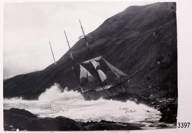 Flagstaff Hill Maritime Museum and Village
Photograph, Mr. H. Pengilley, c. 10/02/1911
This photograph of the wreck SPECULANT was taken shortly after the ship was wreck, sails still on masts. The barquentine SPECULANT was a steel, three-masted sailing ship built in 1895 in Inverkeithing, Scotland, registered in Warrnambool, Victoria and wrecked at Cape Paton, Victoria, 10th February 1911. The SPECULANT had been involved in the timber trade between the United Kingdom and Russia, until sold to its Warrnambool owners and timber merchants Messrs. P.J. McGennan & Co. (Peter John McGennan) in 1902 for 3000 pounds and had her sailed to Warrnambool as her new port. Peter John McGennan was born in 1844 and worked as a builder and cooper in Holyhead, Anglesea, Wales. He immigrated to Australia in 1869 as a free settler and arrived in Warrnambool in 1871 and undertook management of a property in Grassmere for Mr. Palmer. Peter met his wife Emily in South Melbourne and they married in 1873. They had ten children including Harry who lived to 1965, and Andrew who lived until 1958. (The other children were their four brothers - John who was killed in the Dardenalles aged 35, Frederick who died aged 8, Peter who died aged 28, Frank who died aged 5 weeks - and four sisters - Beatrice who died age 89, Edith who died aged 49, Blanche who died aged 89 and Eveline who died aged 48.) In 1874 Peter starting a boating establishment on the Hopkins River. In 1875 he opened up a Coopers business in Kepler Street next to what was Bateman, Smith and Co., moving to Liebig Street, next to the Victoria Hotel, in 1877. In 1882 he then moved to Lava Street (which in later years was the site of Chandlers Hardware Store). He was associated with the establishment of the Butter Factory at Allansford. He started making Butter Boxes to his own design and cheese batts for the Butter Factory. In 1896 established a Box Factory in Davis Street Merrivale, employing 24 people at its peak, (it was burnt down in 1923); and in Pertobe Road from 1912 (now the Army Barracks building). Peter was a Borough Councillor for Albert Ward from 1885 to 1891, he commenced the Foreshore Trust (including the camping grounds along Pertobe Road), and he was an inaugural Director of the Woollen Mill in Harris Street, buying an extensive share-holding in 1908 from the share trader Edward Vidler. They lobbied the Town Hall to have a formal ‘Cutting’ for the waters of the Merri River to be redirected from its natural opening south of Dennington, to its existing opening near Viaduct Road, in order to have the scourings from the wool at the Woollen Mill discharged into the sea. He sold Butter Boxes around the state, and had to ship them to Melbourne by rail. Peter’s purchase of the SPECULANT in 1902 enabled him to back-load white pine from Kaipara, New Zealand to Warrnambool to make his butter boxes then, to gain profitability, buy and ship potatoes and other primary produce bound to Melbourne. (McGennan & Co. had also owned the LA BELLA, which had traded in timber as well, until she was tragically wrecked with the loss of seven lives, after missing the entrance channel to Warrnambool harbour in 1905. It appears that the SPECULANT was bought to replace the LA BELLA.) In 1911 the SPECULANT had been attempting to depart Warrnambool for almost the entire month of January to undergo docking and overhaul in Melbourne. A month of east and south-easterly winds had forced her to remain sheltered in Lady Bay, Warrnambool apart from one morning of northerlies, when an attempt was made to round Cape Otway; she had to return to shelter in Portland after failing to make any headway. With only 140 tons of sand ballast aboard, the ship would not have been easy to handle. Captain Jacobsen and his crew of nine, mainly Swedes, decided to make for Melbourne, leaving Portland Harbour on 5th February 1911. By the 9th they had reached Cape Otway, where they encountered a moonless night, constant heavy rain, and a heavy sea with a south-easterly wind blowing. After safely rounding Cape Otway the course was changed to east, then north-east to take the vessel to a point six miles off Cape Patton, following the orders of Captain Jacobsen, who told the crew to be very careful with the steering, as the wind and sea was running to leeward. The patent log (used to measure speed) had been out of order for the last four months as no-one in Warrnambool was able to fix it: it was intended to have it repaired in Melbourne. In the meantime the crew measured the vessel's speed by looking over the side and estimating wind strength. This compounded the difficulties of imprecise positioning, as the strong cross wind and sea were acting on the lightly laden vessel to steadily drive it towards the shore. At 3.30am on Friday 10 February 1911 Captain Jacobsen and the first mate were looking over the side of the vessel when they heard the sound of breakers and suddenly struck the rocks. The crew immediately knew they had no chance of getting the SPECULANT off, and attempted to rescue themselves by launching the lifeboat, which was instantly smashed to pieces. One of the crew then volunteered to take a line ashore, and the rest of the crew were all able to drag themselves to shore, some suffering hand lacerations from the rocks. Once ashore they began to walk along the coast towards Lorne, believing it was the nearest settlement. Realising their mistake as dawn broke they returned westwards to Cape Patton, and found a farm belonging to Mr C. Ramsden, who took them in and gave them a change of clothes and food. After resting for a day and returning to the wreck to salvage some of their personal possessions, at 10am on Saturday they set out for Apollo Bay, a voyage that took six hours, sometimes wading through flooded creeks up to their necks. The Age described the wreck as "listed to starboard. All the cabin is gutted and the ballast gone. There is a big rock right through the bottom of her, and there is not the slightest hope of getting her off". A Board of Marine inquiry found that Captain Jacobson was guilty of careless navigation by not taking steps to accurately verify the position of the vessel with respect to Cape Otway when the light was visible and by not setting a safe and proper course with respect to the wind and sea. It suspended his certificate for 6 months and ordered him to pay costs. The location of the wreck site was marked for a long time by two anchors on the shoreline, until in 1970 the larger of the two anchors was recovered by the Underwater Explorers' Club and mounted on the foreshore at Apollo Bay. The bell from the wreck was also donated to the Apollo Bay Surf Lifesaving Club but is recorded to have been stolen. Rusting remains of the wreck can still be found on the shoreline on the southern side of, and directly below Cape Patton. Parts of the SPECULANT site have been buried by rubble from construction and maintenance works to the Great Ocean Road, as well as by naturally occurring landslides. Peter J McGennan passed away in 1920. The Gates in the western wall of the Anglican Church in Henna Street/Koroit St are dedicated to him for his time of community work, which is matched with other prominent Warrnambool citizens; Fletcher Jones, John Younger, J.D.E (Tag) Walter, and Edward Vidler. After Peter J McGennan's death Harry, Andrew and Edith continued to operate the family business until July 11th 1923 when the company was wound up. (Andrew lived in Ryot Street Warrnambool, near Lava Street.) Harry McGennan (Peter and Emily’s son) owned the Criterion Hotel in Kepler Street Warrnambool (now demolished). His son Sid and wife Dot lived in 28 Howard Street (corner of Nelson Street) and Sid managed the Criterion until it was decided by the family to sell, and for he remained Manager for the new owners until he retired. Harry commenced the Foreshore Trust in Warrnambool around 1950. The McGennan Carpark in Pertobe Road is named after Harry and there are Memorial-Stone Gates in his memory. (The Gates were once the original entrance to the carpark but are now the exit.). Peter’s great-grandson, also called Andrew, is a Security Officer in Warrnambool. The Patent Log (also called a Taffrail log) from the SPECULANT, mentioned above, and a number of photographs, are now part of the Collection at Flagstaff Hill Maritime Village. The SPECULANT is historically significant as the largest ship to have been registered in Warrnambool, and is believed to have been the largest barquentine to visit Melbourne. It is evidence of the final days of large commercial sailing vessels involved in the Victorian and New Zealand timber trade. The SPECULANT is listed on the Victorian Heritage Register VHR S626Black and White photograph of the Barquentine Speculant, on rocks at Cape Patton, sails still up, steep hill in background. Black pen written on pfront of photograph "Wreck Speculant", "Cape Patten". On reverse side it states that the photograph was taken by Mr. H. Pengilley Apollo Bay Hotel, Apollo Bay On front, Black pen written on pfront of photograph "Wreck Speculant", "Cape Patten". On reverse, "taken by Mr. H. Pengilley Apollo Bay Hotel, Apollo Bay "flagstaff hill, warrnambool, shipwrecked-coast, flagstaff-hill, flagstaff-hill-maritime-museum, maritime-museum, shipwreck-coast, flagstaff-hill-maritime-village, la bella, speculant, cumming and ellis, international timber trade, p. j. mcgennan and co. warrnambool, peter mcgennan, capt. james jacobsen, warrnambool maritime history, h. pengilley apollo bay, cape patton victoria, warrnambool historical photograph -
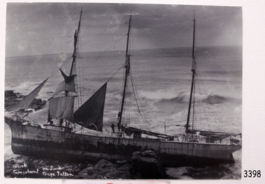 Flagstaff Hill Maritime Museum and Village
Photograph, Mr. H. Pengilley, c. 10/02/1911
This photograph was taken shortly after the wreck of the SPECULANT at Cape Patton, Victoria. There are people on board the ship and it seems that they are taking the sails down. The barquentine SPECULANT was a steel, three-masted sailing ship built in 1895 in Inverkeithing, Scotland, registered in Warrnambool, Victoria and wrecked at Cape Paton, Victoria, 10th February 1911. The SPECULANT had been involved in the timber trade between the United Kingdom and Russia, until sold to its Warrnambool owners and timber merchants Messrs. P.J. McGennan & Co. (Peter John McGennan) in 1902 for 3000 pounds and had her sailed to Warrnambool as her new port. Peter John McGennan was born in 1844 and worked as a builder and cooper in Holyhead, Anglesea, Wales. He immigrated to Australia in 1869 as a free settler and arrived in Warrnambool in 1871 and undertook management of a property in Grassmere for Mr. Palmer. Peter met his wife Emily in South Melbourne and they married in 1873. They had ten children including Harry who lived to 1965, and Andrew who lived until 1958. (The other children were their four brothers - John who was killed in the Dardenalles aged 35, Frederick who died aged 8, Peter who died aged 28, Frank who died aged 5 weeks - and four sisters - Beatrice who died age 89, Edith who died aged 49, Blanche who died aged 89 and Eveline who died aged 48.) In 1874 Peter starting a boating establishment on the Hopkins River. In 1875 he opened up a Coopers business in Kepler Street next to what was Bateman, Smith and Co., moving to Liebig Street, next to the Victoria Hotel, in 1877. In 1882 he then moved to Lava Street (which in later years was the site of Chandlers Hardware Store). He was associated with the establishment of the Butter Factory at Allansford. He started making Butter Boxes to his own design and cheese batts for the Butter Factory. In 1896 established a Box Factory in Davis Street Merrivale, employing 24 people at its peak, (it was burnt down in 1923); and in Pertobe Road from 1912 (now the Army Barracks building). Peter was a Borough Councillor for Albert Ward from 1885 to 1891, he commenced the Foreshore Trust (including the camping grounds along Pertobe Road), and he was an inaugural Director of the Woollen Mill in Harris Street, buying an extensive share-holding in 1908 from the share trader Edward Vidler. They lobbied the Town Hall to have a formal ‘Cutting’ for the waters of the Merri River to be redirected from its natural opening south of Dennington, to its existing opening near Viaduct Road, in order to have the scourings from the wool at the Woollen Mill discharged into the sea. He sold Butter Boxes around the state, and had to ship them to Melbourne by rail. Peter’s purchase of the SPECULANT in 1902 enabled him to back-load white pine from Kaipara, New Zealand to Warrnambool to make his butter boxes then, to gain profitability, buy and ship potatoes and other primary produce bound to Melbourne. (McGennan & Co. had also owned the LA BELLA, which had traded in timber as well, until she was tragically wrecked with the loss of seven lives, after missing the entrance channel to Warrnambool harbour in 1905. It appears that the SPECULANT was bought to replace the LA BELLA.) In 1911 the SPECULANT had been attempting to depart Warrnambool for almost the entire month of January to undergo docking and overhaul in Melbourne. A month of east and south-easterly winds had forced her to remain sheltered in Lady Bay, Warrnambool apart from one morning of northerlies, when an attempt was made to round Cape Otway; she had to return to shelter in Portland after failing to make any headway. With only 140 tons of sand ballast aboard, the ship would not have been easy to handle. Captain Jacobsen and his crew of nine, mainly Swedes, decided to make for Melbourne, leaving Portland Harbour on 5th February 1911. By the 9th they had reached Cape Otway, where they encountered a moonless night, constant heavy rain, and a heavy sea with a south-easterly wind blowing. After safely rounding Cape Otway the course was changed to east, then north-east to take the vessel to a point six miles off Cape Patton, following the orders of Captain Jacobsen, who told the crew to be very careful with the steering, as the wind and sea was running to leeward. The patent log (used to measure speed) had been out of order for the last four months as no-one in Warrnambool was able to fix it: it was intended to have it repaired in Melbourne. In the meantime the crew measured the vessel's speed by looking over the side and estimating wind strength. This compounded the difficulties of imprecise positioning, as the strong cross wind and sea were acting on the lightly laden vessel to steadily drive it towards the shore. At 3.30am on Friday 10 February 1911 Captain Jacobsen and the first mate were looking over the side of the vessel when they heard the sound of breakers and suddenly struck the rocks. The crew immediately knew they had no chance of getting the SPECULANT off, and attempted to rescue themselves by launching the lifeboat, which was instantly smashed to pieces. One of the crew then volunteered to take a line ashore, and the rest of the crew were all able to drag themselves to shore, some suffering hand lacerations from the rocks. Once ashore they began to walk along the coast towards Lorne, believing it was the nearest settlement. Realising their mistake as dawn broke they returned westwards to Cape Patton, and found a farm belonging to Mr C. Ramsden, who took them in and gave them a change of clothes and food. After resting for a day and returning to the wreck to salvage some of their personal possessions, at 10am on Saturday they set out for Apollo Bay, a voyage that took six hours, sometimes wading through flooded creeks up to their necks. The Age described the wreck as "listed to starboard. All the cabin is gutted and the ballast gone. There is a big rock right through the bottom of her, and there is not the slightest hope of getting her off". A Board of Marine inquiry found that Captain Jacobson was guilty of careless navigation by not taking steps to accurately verify the position of the vessel with respect to Cape Otway when the light was visible and by not setting a safe and proper course with respect to the wind and sea. It suspended his certificate for 6 months and ordered him to pay costs. The location of the wreck site was marked for a long time by two anchors on the shoreline, until in 1970 the larger of the two anchors was recovered by the Underwater Explorers' Club and mounted on the foreshore at Apollo Bay. The bell from the wreck was also donated to the Apollo Bay Surf Lifesaving Club but is recorded to have been stolen. Rusting remains of the wreck can still be found on the shoreline on the southern side of, and directly below Cape Patton. Parts of the SPECULANT site have been buried by rubble from construction and maintenance works to the Great Ocean Road, as well as by naturally occurring landslides. Peter J McGennan passed away in 1920. The Gates in the western wall of the Anglican Church in Henna Street/Koroit St are dedicated to him for his time of community work, which is matched with other prominent Warrnambool citizens; Fletcher Jones, John Younger, J.D.E (Tag) Walter, and Edward Vidler. After Peter J McGennan's death Harry, Andrew and Edith continued to operate the family business until July 11th 1923 when the company was wound up. (Andrew lived in Ryot Street Warrnambool, near Lava Street.) Harry McGennan (Peter and Emily’s son) owned the Criterion Hotel in Kepler Street Warrnambool (now demolished). His son Sid and wife Dot lived in 28 Howard Street (corner of Nelson Street) and Sid managed the Criterion until it was decided by the family to sell, and for he remained Manager for the new owners until he retired. Harry commenced the Foreshore Trust in Warrnambool around 1950. The McGennan Carpark in Pertobe Road is named after Harry and there are Memorial-Stone Gates in his memory. (The Gates were once the original entrance to the carpark but are now the exit.). Peter’s great-grandson, also called Andrew, is a Security Officer in Warrnambool. The Patent Log (also called a Taffrail log) from the SPECULANT, mentioned above, and a number of photographs, are now part of the Collection at Flagstaff Hill Maritime Village. The SPECULANT is historically significant as the largest ship to have been registered in Warrnambool, and is believed to have been the largest barquentine to visit Melbourne. It is evidence of the final days of large commercial sailing vessels involved in the Victorian and New Zealand timber trade. The SPECULANT is listed on the Victorian Heritage Register VHR S626Black and White photograph of the Barquentine Speculant, on rocks at Cape Patton. Several people are on board. Some sails are still on masts. White hand writing on front "Wreck Speculant On Rocks Cape Patten". On reverse side it states that the photograph was taken by Mr. H. Pengilley Apollo Bay Hotel, Apollo Bay. on front, hand written in white "Wreck Speculant On Rocks Cape Patten". On reverse "taken by Mr. H. Pengilley Apollo Bay Hotel, Apollo Bay"flagstaff hill, warrnambool, shipwrecked-coast, flagstaff-hill, flagstaff-hill-maritime-museum, maritime-museum, shipwreck-coast, flagstaff-hill-maritime-village, mr. h. pengilley, photograph, speculant, cape patton, apollo bay -
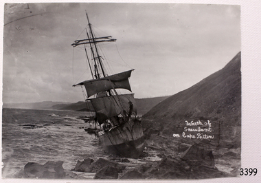 Flagstaff Hill Maritime Museum and Village
Photograph, Mr. H. Pengilley, c. 10/02/1911
Photograph of the wrecked SPECULANT taken shortly after the ship was wrecked at Cape Patton, Victoria. The barquentine SPECULANT was a steel, three-masted sailing ship built in 1895 in Inverkeithing, Scotland, registered in Warrnambool, Victoria and wrecked at Cape Paton, Victoria, 10th February 1911. The SPECULANT had been involved in the timber trade between the United Kingdom and Russia, until sold to its Warrnambool owners and timber merchants Messrs. P.J. McGennan & Co. (Peter John McGennan) in 1902 for 3000 pounds and had her sailed to Warrnambool as her new port. Peter John McGennan was born in 1844 and worked as a builder and cooper in Holyhead, Anglesea, Wales. He immigrated to Australia in 1869 as a free settler and arrived in Warrnambool in 1871 and undertook management of a property in Grassmere for Mr. Palmer. Peter met his wife Emily in South Melbourne and they married in 1873. They had ten children including Harry who lived to 1965, and Andrew who lived until 1958. (The other children were their four brothers - John who was killed in the Dardenalles aged 35, Frederick who died aged 8, Peter who died aged 28, Frank who died aged 5 weeks - and four sisters - Beatrice who died age 89, Edith who died aged 49, Blanche who died aged 89 and Eveline who died aged 48.) In 1874 Peter starting a boating establishment on the Hopkins River. In 1875 he opened up a Coopers business in Kepler Street next to what was Bateman, Smith and Co., moving to Liebig Street, next to the Victoria Hotel, in 1877. In 1882 he then moved to Lava Street (which in later years was the site of Chandlers Hardware Store). He was associated with the establishment of the Butter Factory at Allansford. He started making Butter Boxes to his own design and cheese batts for the Butter Factory. In 1896 established a Box Factory in Davis Street Merrivale, employing 24 people at its peak, (it was burnt down in 1923); and in Pertobe Road from 1912 (now the Army Barracks building). Peter was a Borough Councillor for Albert Ward from 1885 to 1891, he commenced the Foreshore Trust (including the camping grounds along Pertobe Road), and he was an inaugural Director of the Woollen Mill in Harris Street, buying an extensive share-holding in 1908 from the share trader Edward Vidler. They lobbied the Town Hall to have a formal ‘Cutting’ for the waters of the Merri River to be redirected from its natural opening south of Dennington, to its existing opening near Viaduct Road, in order to have the scourings from the wool at the Woollen Mill discharged into the sea. He sold Butter Boxes around the state, and had to ship them to Melbourne by rail. Peter’s purchase of the SPECULANT in 1902 enabled him to back-load white pine from Kaipara, New Zealand to Warrnambool to make his butter boxes then, to gain profitability, buy and ship potatoes and other primary produce bound to Melbourne. (McGennan & Co. had also owned the LA BELLA, which had traded in timber as well, until she was tragically wrecked with the loss of seven lives, after missing the entrance channel to Warrnambool harbour in 1905. It appears that the SPECULANT was bought to replace the LA BELLA.) In 1911 the SPECULANT had been attempting to depart Warrnambool for almost the entire month of January to undergo docking and overhaul in Melbourne. A month of east and south-easterly winds had forced her to remain sheltered in Lady Bay, Warrnambool apart from one morning of northerlies, when an attempt was made to round Cape Otway; she had to return to shelter in Portland after failing to make any headway. With only 140 tons of sand ballast aboard, the ship would not have been easy to handle. Captain Jacobsen and his crew of nine, mainly Swedes, decided to make for Melbourne, leaving Portland Harbour on 5th February 1911. By the 9th they had reached Cape Otway, where they encountered a moonless night, constant heavy rain, and a heavy sea with a south-easterly wind blowing. After safely rounding Cape Otway the course was changed to east, then north-east to take the vessel to a point six miles off Cape Patton, following the orders of Captain Jacobsen, who told the crew to be very careful with the steering, as the wind and sea was running to leeward. The patent log (used to measure speed) had been out of order for the last four months as no-one in Warrnambool was able to fix it: it was intended to have it repaired in Melbourne. In the meantime the crew measured the vessel's speed by looking over the side and estimating wind strength. This compounded the difficulties of imprecise positioning, as the strong cross wind and sea were acting on the lightly laden vessel to steadily drive it towards the shore. At 3.30am on Friday 10 February 1911 Captain Jacobsen and the first mate were looking over the side of the vessel when they heard the sound of breakers and suddenly struck the rocks. The crew immediately knew they had no chance of getting the SPECULANT off, and attempted to rescue themselves by launching the lifeboat, which was instantly smashed to pieces. One of the crew then volunteered to take a line ashore, and the rest of the crew were all able to drag themselves to shore, some suffering hand lacerations from the rocks. Once ashore they began to walk along the coast towards Lorne, believing it was the nearest settlement. Realising their mistake as dawn broke they returned westwards to Cape Patton, and found a farm belonging to Mr C. Ramsden, who took them in and gave them a change of clothes and food. After resting for a day and returning to the wreck to salvage some of their personal possessions, at 10am on Saturday they set out for Apollo Bay, a voyage that took six hours, sometimes wading through flooded creeks up to their necks. The Age described the wreck as "listed to starboard. All the cabin is gutted and the ballast gone. There is a big rock right through the bottom of her, and there is not the slightest hope of getting her off". A Board of Marine inquiry found that Captain Jacobson was guilty of careless navigation by not taking steps to accurately verify the position of the vessel with respect to Cape Otway when the light was visible and by not setting a safe and proper course with respect to the wind and sea. It suspended his certificate for 6 months and ordered him to pay costs. The location of the wreck site was marked for a long time by two anchors on the shoreline, until in 1970 the larger of the two anchors was recovered by the Underwater Explorers' Club and mounted on the foreshore at Apollo Bay. The bell from the wreck was also donated to the Apollo Bay Surf Lifesaving Club but is recorded to have been stolen. Rusting remains of the wreck can still be found on the shoreline on the southern side of, and directly below Cape Patton. Parts of the SPECULANT site have been buried by rubble from construction and maintenance works to the Great Ocean Road, as well as by naturally occurring landslides. Peter J McGennan passed away in 1920. The Gates in the western wall of the Anglican Church in Henna Street/Koroit St are dedicated to him for his time of community work, which is matched with other prominent Warrnambool citizens; Fletcher Jones, John Younger, J.D.E (Tag) Walter, and Edward Vidler. After Peter J McGennan's death Harry, Andrew and Edith continued to operate the family business until July 11th 1923 when the company was wound up. (Andrew lived in Ryot Street Warrnambool, near Lava Street.) Harry McGennan (Peter and Emily’s son) owned the Criterion Hotel in Kepler Street Warrnambool (now demolished). His son Sid and wife Dot lived in 28 Howard Street (corner of Nelson Street) and Sid managed the Criterion until it was decided by the family to sell, and for he remained Manager for the new owners until he retired. Harry commenced the Foreshore Trust in Warrnambool around 1950. The McGennan Carpark in Pertobe Road is named after Harry and there are Memorial-Stone Gates in his memory. (The Gates were once the original entrance to the carpark but are now the exit.). Peter’s great-grandson, also called Andrew, is a Security Officer in Warrnambool. The Patent Log (also called a Taffrail log) from the SPECULANT, mentioned above, and a number of photographs, are now part of the Collection at Flagstaff Hill Maritime Village. The SPECULANT is historically significant as the largest ship to have been registered in Warrnambool, and is believed to have been the largest barquentine to visit Melbourne. It is evidence of the final days of large commercial sailing vessels involved in the Victorian and New Zealand timber trade. The SPECULANT is listed on the Victorian Heritage Register VHR S626Black and White photograph of the Barquentine Speculant, on rocks at Cape Patton. On front hand written in white "Wreck of Speculant on Cape Patten". On reverse side it states that the photograph was "taken by Mr. H. Pengilley Apollo Bay Hotel, Apollo Bay" On front, white hand writing, "Wreck of Speculant on Cape Patten". On reverse "taken by Mr. H. Pengilley Apollo Bay Hotel, Apollo Bay" flagstaff hill, warrnambool, shipwrecked-coast, flagstaff-hill, flagstaff-hill-maritime-museum, maritime-museum, shipwreck-coast, flagstaff-hill-maritime-village, la bella, speculant, cumming and ellis, international timber trade, p. j. mcgennan and co. warrnambool, peter mcgennan, capt. james jacobsen, warrnambool maritime history, h. pengilley apollo bay, cape patton victoria, warrnambool historical photograph -
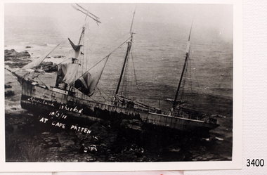 Flagstaff Hill Maritime Museum and Village
Photograph, c. 10/02/1911
Photograph of the wreck of the barque SPECULANT, wrecked at Cape Patton, Victoria. The barquentine SPECULANT was a steel, three-masted sailing ship built in 1895 in Inverkeithing, Scotland, registered in Warrnambool, Victoria and wrecked at Cape Paton, Victoria, 10th February 1911. The SPECULANT had been involved in the timber trade between the United Kingdom and Russia, until sold to its Warrnambool owners and timber merchants Messrs. P.J. McGennan & Co. (Peter John McGennan) in 1902 for 3000 pounds and had her sailed to Warrnambool as her new port. Peter John McGennan was born in 1844 and worked as a builder and cooper in Holyhead, Anglesea, Wales. He immigrated to Australia in 1869 as a free settler and arrived in Warrnambool in 1871 and undertook management of a property in Grassmere for Mr. Palmer. Peter met his wife Emily in South Melbourne and they married in 1873. They had ten children including Harry who lived to 1965, and Andrew who lived until 1958. (The other children were their four brothers - John who was killed in the Dardenalles aged 35, Frederick who died aged 8, Peter who died aged 28, Frank who died aged 5 weeks - and four sisters - Beatrice who died age 89, Edith who died aged 49, Blanche who died aged 89 and Eveline who died aged 48.) In 1874 Peter starting a boating establishment on the Hopkins River. In 1875 he opened up a Coopers business in Kepler Street next to what was Bateman, Smith and Co., moving to Liebig Street, next to the Victoria Hotel, in 1877. In 1882 he then moved to Lava Street (which in later years was the site of Chandlers Hardware Store). He was associated with the establishment of the Butter Factory at Allansford. He started making Butter Boxes to his own design and cheese batts for the Butter Factory. In 1896 established a Box Factory in Davis Street Merrivale, employing 24 people at its peak, (it was burnt down in 1923); and in Pertobe Road from 1912 (now the Army Barracks building). Peter was a Borough Councillor for Albert Ward from 1885 to 1891, he commenced the Foreshore Trust (including the camping grounds along Pertobe Road), and he was an inaugural Director of the Woollen Mill in Harris Street, buying an extensive share-holding in 1908 from the share trader Edward Vidler. They lobbied the Town Hall to have a formal ‘Cutting’ for the waters of the Merri River to be redirected from its natural opening south of Dennington, to its existing opening near Viaduct Road, in order to have the scourings from the wool at the Woollen Mill discharged into the sea. He sold Butter Boxes around the state, and had to ship them to Melbourne by rail. Peter’s purchase of the SPECULANT in 1902 enabled him to back-load white pine from Kaipara, New Zealand to Warrnambool to make his butter boxes then, to gain profitability, buy and ship potatoes and other primary produce bound to Melbourne. (McGennan & Co. had also owned the LA BELLA, which had traded in timber as well, until she was tragically wrecked with the loss of seven lives, after missing the entrance channel to Warrnambool harbour in 1905. It appears that the SPECULANT was bought to replace the LA BELLA.) In 1911 the SPECULANT had been attempting to depart Warrnambool for almost the entire month of January to undergo docking and overhaul in Melbourne. A month of east and south-easterly winds had forced her to remain sheltered in Lady Bay, Warrnambool apart from one morning of northerlies, when an attempt was made to round Cape Otway; she had to return to shelter in Portland after failing to make any headway. With only 140 tons of sand ballast aboard, the ship would not have been easy to handle. Captain Jacobsen and his crew of nine, mainly Swedes, decided to make for Melbourne, leaving Portland Harbour on 5th February 1911. By the 9th they had reached Cape Otway, where they encountered a moonless night, constant heavy rain, and a heavy sea with a south-easterly wind blowing. After safely rounding Cape Otway the course was changed to east, then north-east to take the vessel to a point six miles off Cape Patton, following the orders of Captain Jacobsen, who told the crew to be very careful with the steering, as the wind and sea was running to leeward. The patent log (used to measure speed) had been out of order for the last four months as no-one in Warrnambool was able to fix it: it was intended to have it repaired in Melbourne. In the meantime the crew measured the vessel's speed by looking over the side and estimating wind strength. This compounded the difficulties of imprecise positioning, as the strong cross wind and sea were acting on the lightly laden vessel to steadily drive it towards the shore. At 3.30am on Friday 10 February 1911 Captain Jacobsen and the first mate were looking over the side of the vessel when they heard the sound of breakers and suddenly struck the rocks. The crew immediately knew they had no chance of getting the SPECULANT off, and attempted to rescue themselves by launching the lifeboat, which was instantly smashed to pieces. One of the crew then volunteered to take a line ashore, and the rest of the crew were all able to drag themselves to shore, some suffering hand lacerations from the rocks. Once ashore they began to walk along the coast towards Lorne, believing it was the nearest settlement. Realising their mistake as dawn broke they returned westwards to Cape Patton, and found a farm belonging to Mr C. Ramsden, who took them in and gave them a change of clothes and food. After resting for a day and returning to the wreck to salvage some of their personal possessions, at 10am on Saturday they set out for Apollo Bay, a voyage that took six hours, sometimes wading through flooded creeks up to their necks. The Age described the wreck as "listed to starboard. All the cabin is gutted and the ballast gone. There is a big rock right through the bottom of her, and there is not the slightest hope of getting her off". A Board of Marine inquiry found that Captain Jacobson was guilty of careless navigation by not taking steps to accurately verify the position of the vessel with respect to Cape Otway when the light was visible and by not setting a safe and proper course with respect to the wind and sea. It suspended his certificate for 6 months and ordered him to pay costs. The location of the wreck site was marked for a long time by two anchors on the shoreline, until in 1970 the larger of the two anchors was recovered by the Underwater Explorers' Club and mounted on the foreshore at Apollo Bay. The bell from the wreck was also donated to the Apollo Bay Surf Lifesaving Club but is recorded to have been stolen. Rusting remains of the wreck can still be found on the shoreline on the southern side of, and directly below Cape Patton. Parts of the SPECULANT site have been buried by rubble from construction and maintenance works to the Great Ocean Road, as well as by naturally occurring landslides. Peter J McGennan passed away in 1920. The Gates in the western wall of the Anglican Church in Henna Street/Koroit St are dedicated to him for his time of community work, which is matched with other prominent Warrnambool citizens; Fletcher Jones, John Younger, J.D.E (Tag) Walter, and Edward Vidler. After Peter J McGennan's death Harry, Andrew and Edith continued to operate the family business until July 11th 1923 when the company was wound up. (Andrew lived in Ryot Street Warrnambool, near Lava Street.) Harry McGennan (Peter and Emily’s son) owned the Criterion Hotel in Kepler Street Warrnambool (now demolished). His son Sid and wife Dot lived in 28 Howard Street (corner of Nelson Street) and Sid managed the Criterion until it was decided by the family to sell, and for he remained Manager for the new owners until he retired. Harry commenced the Foreshore Trust in Warrnambool around 1950. The McGennan Carpark in Pertobe Road is named after Harry and there are Memorial-Stone Gates in his memory. (The Gates were once the original entrance to the carpark but are now the exit.). Peter’s great-grandson, also called Andrew, is a Security Officer in Warrnambool. The Patent Log (also called a Taffrail log) from the SPECULANT, mentioned above, and a number of photographs, are now part of the Collection at Flagstaff Hill Maritime Village. The SPECULANT is historically significant as the largest ship to have been registered in Warrnambool, and is believed to have been the largest barquentine to visit Melbourne. It is evidence of the final days of large commercial sailing vessels involved in the Victorian and New Zealand timber trade. The SPECULANT is listed on the Victorian Heritage Register VHR S626Black and White photograph of the Barquentine Speculant, on rocks at Cape Patton. On front in white hand writing "Speculant wrecked 10/2/11 Cape Patten"."Speculant wrecked 10/2/11 Cape Patten".flagstaff hill, warrnambool, shipwrecked-coast, flagstaff-hill, flagstaff-hill-maritime-museum, maritime-museum, shipwreck-coast, flagstaff-hill-maritime-village, la bella, speculant, cumming and ellis, international timber trade, p. j. mcgennan and co. warrnambool, peter mcgennan, capt. james jacobsen, warrnambool maritime history, h. pengilley apollo bay, cape patton victoria, warrnambool historical photograph -
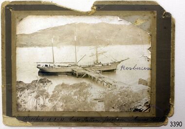 Flagstaff Hill Maritime Museum and Village
Photograph, before 1911
Photograph, black and white, of the three-masted barque SPECULANT at a jetty in low water. On the jetty and the shore are stacks of cut timber. The ship is in a wide river or bay, hills in the background, trees (like gum trees) in the foreground. Inscribed "Wrecked 10.2.11. Cape Patten. Jacobson. Munro. - - - -" Written on the photograph in blue pen "Rosbercon". (The SPECULANT was wrecked on 10th February 2011 at Cape Patton, Victoria, (not Patten as on the photograph). She was sailing under the control of Captain James Jacobsen and her First Mate was James Mumro.) The barquentine SPECULANT was a steel, three-masted sailing ship built in 1895 in Inverkeithing, Scotland, registered in Warrnambool, Victoria and wrecked at Cape Paton, Victoria, 10th February 1911. The SPECULANT had been involved in the timber trade between the United Kingdom and Russia, until sold to its Warrnambool owners and timber merchants Messrs. P.J. McGennan & Co. (Peter John McGennan) in 1902 for 3000 pounds and had her sailed to Warrnambool as her new port. Peter John McGennan was born in 1844 and worked as a builder and cooper in Holyhead, Anglesea, Wales. He immigrated to Australia in 1869 as a free settler and arrived in Warrnambool in 1871 and undertook management of a property in Grassmere for Mr. Palmer. Peter met his wife Emily in South Melbourne and they married in 1873. They had ten children including Harry who lived to 1965, and Andrew who lived until 1958. (The other children were their four brothers - John who was killed in the Dardenalles aged 35, Frederick who died aged 8, Peter who died aged 28, Frank who died aged 5 weeks - and four sisters - Beatrice who died age 89, Edith who died aged 49, Blanche who died aged 89 and Eveline who died aged 48.) In 1874 Peter starting a boating establishment on the Hopkins River. In 1875 he opened up a Coopers business in Kepler Street next to what was Bateman, Smith and Co., moving to Liebig Street, next to the Victoria Hotel, in 1877. In 1882 he then moved to Lava Street (which in later years was the site of Chandlers Hardware Store). He was associated with the establishment of the Butter Factory at Allansford. He started making Butter Boxes to his own design and cheese batts for the Butter Factory. In 1896 established a Box Factory in Davis Street Merrivale, employing 24 people at its peak, (it was burnt down in 1923); and in Pertobe Road from 1912 (now the Army Barracks building). Peter was a Borough Councillor for Albert Ward from 1885 to 1891, he commenced the Foreshore Trust (including the camping grounds along Pertobe Road), and he was an inaugural Director of the Woollen Mill in Harris Street, buying an extensive share-holding in 1908 from the share trader Edward Vidler. They lobbied the Town Hall to have a formal ‘Cutting’ for the waters of the Merri River to be redirected from its natural opening south of Dennington, to its existing opening near Viaduct Road, in order to have the scourings from the wool at the Woollen Mill discharged into the sea. He sold Butter Boxes around the state, and had to ship them to Melbourne by rail. Peter’s purchase of the SPECULANT in 1902 enabled him to back-load white pine from Kaipara, New Zealand to Warrnambool to make his butter boxes then, to gain profitability, buy and ship potatoes and other primary produce bound to Melbourne. (McGennan & Co. had also owned the LA BELLA, which had traded in timber as well, until she was tragically wrecked with the loss of seven lives, after missing the entrance channel to Warrnambool harbour in 1905. It appears that the SPECULANT was bought to replace the LA BELLA.) In 1911 the SPECULANT had been attempting to depart Warrnambool for almost the entire month of January to undergo docking and overhaul in Melbourne. A month of east and south-easterly winds had forced her to remain sheltered in Lady Bay, Warrnambool apart from one morning of northerlies, when an attempt was made to round Cape Otway; she had to return to shelter in Portland after failing to make any headway. With only 140 tons of sand ballast aboard, the ship would not have been easy to handle. Captain Jacobsen and his crew of nine, mainly Swedes, decided to make for Melbourne, leaving Portland Harbour on 5th February 1911. By the 9th they had reached Cape Otway, where they encountered a moonless night, constant heavy rain, and a heavy sea with a south-easterly wind blowing. After safely rounding Cape Otway the course was changed to east, then north-east to take the vessel to a point six miles off Cape Patton, following the orders of Captain Jacobsen, who told the crew to be very careful with the steering, as the wind and sea was running to leeward. The patent log (used to measure speed) had been out of order for the last four months as no-one in Warrnambool was able to fix it: it was intended to have it repaired in Melbourne. In the meantime the crew measured the vessel's speed by looking over the side and estimating wind strength. This compounded the difficulties of imprecise positioning, as the strong cross wind and sea were acting on the lightly laden vessel to steadily drive it towards the shore. At 3.30am on Friday 10 February 1911 Captain Jacobsen and the first mate were looking over the side of the vessel when they heard the sound of breakers and suddenly struck the rocks. The crew immediately knew they had no chance of getting the SPECULANT off, and attempted to rescue themselves by launching the lifeboat, which was instantly smashed to pieces. One of the crew then volunteered to take a line ashore, and the rest of the crew were all able to drag themselves to shore, some suffering hand lacerations from the rocks. Once ashore they began to walk along the coast towards Lorne, believing it was the nearest settlement. Realising their mistake as dawn broke they returned westwards to Cape Patton, and found a farm belonging to Mr C. Ramsden, who took them in and gave them a change of clothes and food. After resting for a day and returning to the wreck to salvage some of their personal possessions, at 10am on Saturday they set out for Apollo Bay, a voyage that took six hours, sometimes wading through flooded creeks up to their necks. The Age described the wreck as "listed to starboard. All the cabin is gutted and the ballast gone. There is a big rock right through the bottom of her, and there is not the slightest hope of getting her off". A Board of Marine inquiry found that Captain Jacobson was guilty of careless navigation by not taking steps to accurately verify the position of the vessel with respect to Cape Otway when the light was visible and by not setting a safe and proper course with respect to the wind and sea. It suspended his certificate for 6 months and ordered him to pay costs. The location of the wreck site was marked for a long time by two anchors on the shoreline, until in 1970 the larger of the two anchors was recovered by the Underwater Explorers' Club and mounted on the foreshore at Apollo Bay. The bell from the wreck was also donated to the Apollo Bay Surf Lifesaving Club but is recorded to have been stolen. Rusting remains of the wreck can still be found on the shoreline on the southern side of, and directly below Cape Patton. Parts of the SPECULANT site have been buried by rubble from construction and maintenance works to the Great Ocean Road, as well as by naturally occurring landslides. Peter J McGennan passed away in 1920. The Gates in the western wall of the Anglican Church in Henna Street/Koroit St are dedicated to him for his time of community work, which is matched with other prominent Warrnambool citizens; Fletcher Jones, John Younger, J.D.E (Tag) Walter, and Edward Vidler. After Peter J McGennan's death Harry, Andrew and Edith continued to operate the family business until July 11th 1923 when the company was wound up. (Andrew lived in Ryot Street Warrnambool, near Lava Street.) Harry McGennan (Peter and Emily’s son) owned the Criterion Hotel in Kepler Street Warrnambool (now demolished). His son Sid and wife Dot lived in 28 Howard Street (corner of Nelson Street) and Sid managed the Criterion until it was decided by the family to sell, and for he remained Manager for the new owners until he retired. Harry commenced the Foreshore Trust in Warrnambool around 1950. The McGennan Carpark in Pertobe Road is named after Harry and there are Memorial-Stone Gates in his memory. (The Gates were once the original entrance to the carpark but are now the exit.). Peter’s great-grandson, also called Andrew, is a Security Officer in Warrnambool. The Patent Log (also called a Taffrail log) from the SPECULANT, mentioned above, and a number of photographs, are now part of the Collection at Flagstaff Hill Maritime Village. The SPECULANT is historically significant as the largest ship to have been registered in Warrnambool, and is believed to have been the largest barquentine to visit Melbourne. It is evidence of the final days of large commercial sailing vessels involved in the Victorian and New Zealand timber trade. The SPECULANT is listed on the Victorian Heritage Register VHR S626Photograph, black and white, of the three-masted barque SPECULANT at a jetty in low water. On the jetty and the shore are stacks of cut timber. The ship is in a wide river or bay, hills in the background, trees (like gum trees) in the foreground. Inscribed below photograph "Wrecked 10.2.11. Cape Patten. Jacobson. Munro. - - - -" Written on the photograph in blue pen "Rosbercon"Inscribed below photograph "Wrecked 10.2.11. Cape Patten. Jacobson. Munro. - - - -" Written on the photograph in blue pen "Rosbercon"flagstaff hill, warrnambool, shipwrecked-coast, flagstaff-hill, flagstaff-hill-maritime-museum, maritime-museum, shipwreck-coast, flagstaff-hill-maritime-village, warrnambool historical photograph, cape patten, munro, james munro, la bella, speculant, cumming and ellis, international timber trade, p. j. mcgennan and co. warrnambool, peter mcgennan, capt. james jacobsen, warrnambool maritime history -
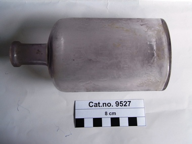 Coal Creek Community Park & Museum
Bottle, glass, c. 1885
150 years of experience and commitment. Norwegians have been producing and exporting cod liver oil for more than 1000 years. But it was not before 1645 it was reported that cod liver oil could be used to prevent and cure disease. At the end of the 18th century the first scientific article was published to support this. In the middle of the 19th century, the pharmacist Peter Möller observed that people along the west coast of Norway consuming cod liver oil regularly were rarely ill. He dedicated himself to finding out how this healthy liquid could be produced with better taste and pureness at a lower price. He developed a method of using steam to extract the oil from fresh cod livers. Based on this technological advance, the company Peter Möller was founded in 1854 in Lofoten on Norway’s arctic coast, where you find pure, cold, clean seas and high quality raw material. Peter Joachim Möller (1793-1869) At first Möller’s Cod Liver Oil was believed to be a good source of vitamin D and A, and the health benefits were associated with these vitamins. Peter Möller believed, however, that there were other significant benefits from fatty acids and other ingredients in the cod liver oil – both known and unknown. Peter Möller was dedicated to understanding more about these benefits. His dedication and commitment is clear in Möller's vision to improve people’s health by delivering the highest quality omega 3 products. Timeline 1793 Peter Möller is born in Røros, Norway 26 April. 1819 Peter Möller travels to Christiania (Oslo) and is employed by the pharmacist Frantz Peckel at the Svane chemist. He is employed on condition that he passes his pharmaceutical exam within one year. 1822 Graduated as a pharmacist with a unanimous first grade and with the award of the Professor's special satisfaction. 1842 Together with professors A. Holst and Chr. Boeck, Peter Möller participates in the commission which develops the first Norwegian Pharmacopoeia. 1853 Peter announces his method to cod liver oil works along the coast. He equips cod liver oil factories with new equipment in Lofoten, Ålesund and Kristiansund. The facility outside Ålesund is the most important for testing the method. 1854 The Peter Möller company is established as production has started at the three factories. Sales are lower than anticipated even though the quality is considerably better with the new method. The consumers of cod liver oil had been used to the fact that “good medicine must taste bad” and would not believe that the new and better quality was as healthy. Therefore, the following years are used to introduce consumers to the product, and also to convert more producers to the new method. 1869 Peter Möller dies. There are 70 cod liver oil steamers which use his steam rendering method, and 5000 barrels are produced every year. Möller’s company increases the quality by better routines for quality controls. 1870 Severin A Heyerdal, Möller’s son-in-law, assumes the leadership of the firm after Peter's death. He continues the work by improving the quality of the cod liver oil. The goal was to make it as pure and unaltered as in the liver. At this time, Möller had already started selling its product in the USA. In 1870, WH Schieffelin & Co. ("The oldest drughouse in America") was engaged by Peter Möller in the USA. 1881 Frantz Peckel Möller assumes the leadership of the Peter Möller company. He saw it as his duty to further the work on cod liver oil, and through a combination of solid scientific education and an eminent sense of the great mercantile possibilities, he made Möller’s cod liver oil the number one in the world market. 1914 The first world war leads to Möller’s bottled cod liver oil being shut out of the export market. However, domestic sales are good. 1924 The subsidiary Møystad Möller & Co. is established for bulk exports and the Association of Medicinal Cod liver oil Exporters is established in Bergen in 1925. 1925/26 The green bottles are introduced. Medicinal cod liver oil exports remain almost constant, while total Norwegian cod liver oil exports increase. 1938 The factory on the Løren grounds in Oslo, Norway is built. The factory is in the same place today. Peter Möller’s Pharmaceutical Laboratorium A/S is also established to separate out the scientific business. Investment is made in a new facility for refining and bottling veterinary cod liver oil, and increased production of industrial cod liver oil. 1940 The outbreak of the 2nd world war sees exports fall dramatically, while cod liver oil’s significance as a dietary supplement receives increased attention. Domestic sales increase strongly. 1945 After the war, medicinal cod liver oil retains its high status as an important dietary supplement in the “rebuilding" of the country. Cod liver oil becomes an ”emergency product in ravaged areas where the supply situation is difficult. Competition from other countries such as the USA, England and Iceland increases, and Norway no longer dominates the market. 1983 Möller’s cod liver oil in capsule form is launched and palatable cod liver oil is launched. 1990 Peter Möller A/S merges with Orkla Borregaard A/S (now ORKLA) 2005 Peter Möller merges with CollettPharma. The new company is called MöllerCollett. 2007 Merger between MöllerCollet and DanskDroge. The new company is called Axellus. Oval in section with a thin neck, mauve tinted clear glass bottle with text embossed on side.On side : 'P.MOLLER', 'OL JECOR', 'GADOR VER', 'CHRISTIANIA'.cod liver oil, norway, peter moller, christiana, oslo -
 Red Cliffs Military Museum
Document, Obituary, 12:MMMM, 1976 (exact); Walter Thomas West passed away 4th December 1976 and his funeral was held 7th of December
Attached to his R.S.L. Membership Card along with the funeral notice, is a subsequent newspaper article written at the time of Walter West's death, which reads: Death of Pioneer Settler/ A pioneer settler of/ the Red Cliffs irigation/ district and one of the/ last men to be evacuated/ from Gallipoli, died sud/denly on Saturday night/ aged 84./ In 1922 Mr. Watler Thomas/ West came to Red Cliffs/ where he established Block/ 86 in the irrigation district./ He lived there until his/ death on Saturday after playing bowls at the Red/ Cliffs rinks on Saturday/ afternoon./ Mr. West was born in Jeparit and served with the/ 24th Battalion in Egypt and/ Gallipoli./ He was awarded the Mili/tary Medal in France in/ 1917 and the Military Cross/ in 1918 when he captured/ single handed an enemy/ machine gun post./ He settled at Red Cliffs/ on his return when the/ area was placed under irri-/gation./ For 25 years he operated/ a unique partnership with/ the late Mr. Martin Nippe, his adjoining property/ owner. The pair pooled their/ horticultural equipment for/ joint use./ Mr. West joined Mildura/ Legacy in 1942 and was an/ active member until his/ death./ The funeral will be held at the United Church, Red/ Cliffs this morning at 10.30Type written obituary, presumably used when Walter West,MC,MM, died.Walter West MC,MM/ Red Cliffs residents were saddened to learn of the sudden passing on Saturday last/ of Walter Thomas West MC,MM., a Pioneer/settler and well respected citizen./ "Wal" as he was affectionately known, was/ born at Dandenong some 84years ago./ He served with distinction in World War 1/ with 24th Battalion. He was an original ANZAC, and also saw service in/ Egypt and France. He received two awards for gallantry in the field - The Military/ Medal in France 1917 and the Military Cross in France/ in 1918 when he was responsible for the/ single handed capture of an enemy gun and crew./ He was an original soldier settler and developed/ his fruit block in Red Cliffs which is still/ operated by his son Tom. In 1922 he/ became an original Trustie of the Methodist/Church and was the last surviving original/ Trustie. He served on the Board of/ directors of the Red Cliffs Co-Operative Co.Ltd/ from 1954 to 1967, and was Chairman of Directors/ in 1963 and 1964. He showed a keen interest/ in youth activities and some excellent cricketers/ were produced as a result of his coaching of/ the Methodist Junior Cricket Team. He was an/ active and keen member of Mildura Legacy/ for 34 years, serving as President in 1947 and 1948./ He was secretary of the Cemetary Trust for many years, served on the Hospital Committee/ was a member of Memorial Lodge, a member of Red Cliffs Senior Citizens Club and a /member of Red Cliffs Sub-Branch R.S.L. since / it's inception./ He was a keen member of the Red Cliffs/ Bowling Club and took part in a club event on/ the day of his passing./ It was the pioneer settler and men with ability/ and initiative of Walter West that brought/ out the Community Spirit which resulted in/ the Red Cliffs we know today.1918, 1917, ww1, walter, thomas, west, mm, mc, 24th, battalion, aif, gallipoli, bullecourt -
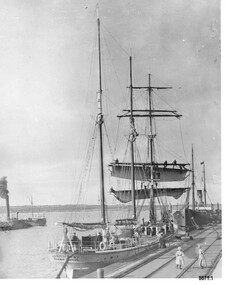 Flagstaff Hill Maritime Museum and Village
Photograph - Vessels Speculant and S. S. Flinders, Between 1902 and 1907
This photograph was one of ten photographs donated to Flagstaff Hill Maritime Museum and Village by Fred Trewartha. Frederick John Fox Trewartha (Fred) was a well-known Warrnambool businessman. He was born in Beeac near Geelong in 1920 and came to Warrnambool with his family as a very young child. He was apprenticed to his father John, as a saddler and later opened his own shop on Raglan Parade. He then moved into working with tarpaulins and canvases for the trucking industry. Fred was keenly interested in photography (and was a member of the Warrnambool Cine Club), yachting and boat building. He kept his yacht moored at Port Fairy for many years and participated in sailing events locally and interstate. He also built boats with his sons. He had the opportunity to meet many older sailors and it's thought this photo (and others in the set) may have been given to him by one of these men. Fred Trewartha died in 2016 in Warrnambool. The two identifiable ships in this picture are the "Speculant" and the "S. S. Flinders" - both coastal trading vessels that regularly came and went from Warrnambool. The third steamer on the left hasn't been identified The barquentine SPECULANT was a steel, three-masted sailing ship built in 1895 in Inverkeithing, Scotland, registered in Warrnambool, Victoria and wrecked at Cape Paton, Victoria, 10th February 1911. The SPECULANT had been involved in the timber trade between the United Kingdom and Russia, until sold to its Warrnambool owners and timber merchants Messrs. P.J. McGennan & Co. (Peter John McGennan) in 1902 for 3000 pounds and had her sailed to Warrnambool as her new port. Peter John McGennan was born in 1844 and worked as a builder and cooper in Holyhead, Anglesea, Wales. He immigrated to Australia in 1869 as a free settler and arrived in Warrnambool in 1871 and undertook management of a property in Grassmere for Mr. Palmer. Peter met his wife Emily in South Melbourne and they married in 1873. They had ten children including Harry who lived to 1965, and Andrew who lived until 1958. (The other children were their four brothers - John who was killed in the Dardenalles aged 35, Frederick who died aged 8, Peter who died aged 28, Frank who died aged 5 weeks - and four sisters - Beatrice who died age 89, Edith who died aged 49, Blanche who died aged 89 and Eveline who died aged 48.) In 1874 Peter starting a boating establishment on the Hopkins River. In 1875 he opened up a Coopers business in Kepler Street next to what was Bateman, Smith and Co., moving to Liebig Street, next to the Victoria Hotel, in 1877. In 1882 he then moved to Lava Street (which in later years was the site of Chandlers Hardware Store). He was associated with the establishment of the Butter Factory at Allansford. He started making Butter Boxes to his own design and cheese batts for the Butter Factory. In 1896 established a Box Factory in Davis Street Merrivale, employing 24 people at its peak, (it was burnt down in 1923); and in Pertobe Road from 1912 (now the Army Barracks building). Peter was a Borough Councillor for Albert Ward from 1885 to 1891, he commenced the Foreshore Trust (including the camping grounds along Pertobe Road), and he was an inaugural Director of the Woollen Mill in Harris Street, buying an extensive share-holding in 1908 from the share trader Edward Vidler. They lobbied the Town Hall to have a formal ‘Cutting’ for the waters of the Merri River to be redirected from its natural opening south of Dennington, to its existing opening near Viaduct Road, in order to have the scourings from the wool at the Woollen Mill discharged into the sea. He sold Butter Boxes around the state, and had to ship them to Melbourne by rail. Peter’s purchase of the SPECULANT in 1902 enabled him to back-load white pine from Kaipara, New Zealand to Warrnambool to make his butter boxes then, to gain profitability, buy and ship potatoes and other primary produce bound to Melbourne. (McGennan & Co. had also owned the LA BELLA, which had traded in timber as well, until she was tragically wrecked with the loss of seven lives, after missing the entrance channel to Warrnambool harbour in 1905. It appears that the SPECULANT was bought to replace the LA BELLA.) In 1911 the SPECULANT had been attempting to depart Warrnambool for almost the entire month of January to undergo docking and overhaul in Melbourne. A month of east and south-easterly winds had forced her to remain sheltered in Lady Bay, Warrnambool apart from one morning of northerlies, when an attempt was made to round Cape Otway; she had to return to shelter in Portland after failing to make any headway. With only 140 tons of sand ballast aboard, the ship would not have been easy to handle. Captain Jacobsen and his crew of nine, mainly Swedes, decided to make for Melbourne, leaving Portland Harbour on 5th February 1911. By the 9th they had reached Cape Otway, where they encountered a moonless night, constant heavy rain, and a heavy sea with a south-easterly wind blowing. After safely rounding Cape Otway the course was changed to east, then north-east to take the vessel to a point six miles off Cape Patton, following the orders of Captain Jacobsen, who told the crew to be very careful with the steering, as the wind and sea was running to leeward. The patent log (used to measure speed) had been out of order for the last four months as no-one in Warrnambool was able to fix it: it was intended to have it repaired in Melbourne. In the meantime the crew measured the vessel's speed by looking over the side and estimating wind strength. This compounded the difficulties of imprecise positioning, as the strong cross wind and sea were acting on the lightly laden vessel to steadily drive it towards the shore. At 3.30am on Friday 10 February 1911 Captain Jacobsen and the first mate were looking over the side of the vessel when they heard the sound of breakers and suddenly struck the rocks. The crew immediately knew they had no chance of getting the SPECULANT off, and attempted to rescue themselves by launching the lifeboat, which was instantly smashed to pieces. One of the crew then volunteered to take a line ashore, and the rest of the crew were all able to drag themselves to shore, some suffering hand lacerations from the rocks. Once ashore they began to walk along the coast towards Lorne, believing it was the nearest settlement. Realising their mistake as dawn broke they returned westwards to Cape Patton, and found a farm belonging to Mr C. Ramsden, who took them in and gave them a change of clothes and food. After resting for a day and returning to the wreck to salvage some of their personal possessions, at 10am on Saturday they set out for Apollo Bay, a voyage that took six hours, sometimes wading through flooded creeks up to their necks. The Age described the wreck as "listed to starboard. All the cabin is gutted and the ballast gone. There is a big rock right through the bottom of her, and there is not the slightest hope of getting her off". A Board of Marine inquiry found that Captain Jacobson was guilty of careless navigation by not taking steps to accurately verify the position of the vessel with respect to Cape Otway when the light was visible and by not setting a safe and proper course with respect to the wind and sea. It suspended his certificate for 6 months and ordered him to pay costs. The location of the wreck site was marked for a long time by two anchors on the shoreline, until in 1970 the larger of the two anchors was recovered by the Underwater Explorers' Club and mounted on the foreshore at Apollo Bay. The bell from the wreck was also donated to the Apollo Bay Surf Lifesaving Club but is recorded to have been stolen. Rusting remains of the wreck can still be found on the shoreline on the southern side of, and directly below Cape Patton. Parts of the SPECULANT site have been buried by rubble from construction and maintenance works to the Great Ocean Road, as well as by naturally occurring landslides. Peter J McGennan passed away in 1920. The Gates in the western wall of the Anglican Church in Henna Street/Koroit St are dedicated to him for his time of community work, which is matched with other prominent Warrnambool citizens; Fletcher Jones, John Younger, J.D.E (Tag) Walter, and Edward Vidler. After Peter J McGennan's death Harry, Andrew and Edith continued to operate the family business until July 11th 1923 when the company was wound up. (Andrew lived in Ryot Street Warrnambool, near Lava Street.) Harry McGennan (Peter and Emily’s son) owned the Criterion Hotel in Kepler Street Warrnambool (now demolished). His son Sid and wife Dot lived in 28 Howard Street (corner of Nelson Street) and Sid managed the Criterion until it was decided by the family to sell, and for he remained Manager for the new owners until he retired. Harry commenced the Foreshore Trust in Warrnambool around 1950. The McGennan Carpark in Pertobe Road is named after Harry and there are Memorial-Stone Gates in his memory. (The Gates were once the original entrance to the carpark but are now the exit.). The Patent Log (also called a Taffrail log) from the SPECULANT, mentioned above, and a number of photographs, are now part of the Collection at Flagstaff Hill Maritime Village.. The S. S. Flinders was built by A. J. Inglis, Ltd, Pointhouse, Glasgow in 1878 for the "Tasmanian Steam Navigation Company', Hobart which merged with the "Union Steamship Company" of New Zealand and it was later sold to the firm "McIlwraith, McEacham and Company". It was built of iron and was 1000 tons and 227 feet, 1 inch long. It was described as "splendidly fitted up for the carriage of passengers and her cargo space was also very large". In the saloon about 130 passengers could be accommodated while the second class had sufficient room for one hundred passengers. In 1890, the S. S. Flinders would leave Melbourne on Mondays and Thursdays at 5 pm and reach Warrnambool the following morning at 8 am. On the return it would leave Warrnambool on Wednesdays and Saturdays at 5 pm and reach Melbourne the following morning. In 1896, the Weekly Times described the "steamer Flinders (otherwise known as "the Warrnambool mailboat") as "as good a sample of a seagoing steamer as there is trading on the Victorian Coast at the present time". In April 1896 newspaper reports noted the S. S. Flinders took 2915 bags of potatoes from Warrnambool to Melbourne (the largest shipment of that season) as well as 50 tons of tinned rabbits from the Hamilton Preserving Factory. It was also noted that particularly during the Christmas period, there were excessive demands for berths from holiday makers wanting to enjoy a holiday in Warrnambool. In May 1903, the S. S. Flinders narrowly escaped destruction when an explosion and subsequent fire occurred during the passage from Melbourne to Warrnambool. A drum (which apparently contained carbide of calcium) exploded and blew off a hatch cover. As the steamer got to within a mile or two of Warrnambool, smoke was seen coming out of the hold and (unknown to the passengers) flames had taken hold. The crew quickly got to work - closing down all the hatches and pumping water into the hold through a hole in the saloon floor. There were 30 or 40 cases of kerosene on board. The Flinders continued on to Warrnambool and berthed at the Breakwater. The passengers all went ashore - many unaware of the danger they had been in. A telephone message was sent to the local Fire Brigade Station however the fire was extinguished before the firemen and their equipment arrived. After the hold was checked, the Flinders was certified as seaworthy and left for Portland. The Flinders continued to transport Western District produce as well as passengers from Warrnambool to Melbourne until 1906 when (due to a decrease in shipping trade during the Winter and the availability of train services) the Flinders was replaced by the smaller steamer "Dawn" and in 1907 when it was sold to the "Adelaide Steamship Company" for use in the Western Australia coastal trade, it was replaced by the "S. S. Barrabool".This photograph is a significant record of two of the well known coastal traders (the "Speculant" and the "Flinders") that sailed along the south west coast of Victoria for many years - transporting goods and passengers between Melbourne and Warrnambool.Black and white photograph of the Breakwater in Warrnambool with two ships docked and another in the bay. On the front boat (the Speculant), men can be seen at the wheel, on the deck and on the bottom two booms where they appear to be furling the sails. The sails of the top booms are already furled. A small boy can be seen on the deck and a young girl, two women and a dog are on the Breakwater. There is a steam ship (the S. S. Flinders) tied up behind the "Speculant" and an unidentified steam ship (with smoke coming from its smokestack) in the bay. There is a blue and black handwritten label on the back of the photo - naming the ships and the owner of the photo.Speculant and Flinders / Passenger ship in / Lady Bay / name of donor and phone numberflagstaff hill maritime museum and village, warrnambool, great ocean road, shipwreck coast, speculant, barque speculant, flinders, s. s. finders, steamship flinders, coastal trader, passenger ship, goods, steamer, breakwater, lady bay, warrnambool mailboat, p. j. mcgennan, peter john mcgennan, butter boxes, captain jacobsen, cape patton, tasmanian steam navigation company -
 Flagstaff Hill Maritime Museum and Village
Financial record - Passbook, Bank of Australasia, 1880
This bank passbook originated from the Warrnambool branch of the Bank of Australasia with handwritten entries dating from 1880. Names written in the passbook are likely to be people local to Warrnambool. The book belonged to Thomas Smith and was handed over to his Executors. Thomas Smith operated his Gas Printers Works from Koroit Street, Warrnambool, and was a member of the Odd Fellows. In 1878 his son, aged about 12 years old, was carried across a tightrope forward and backwards, on the shoulders of the "Australian Blondon" Mr. L' Estrange, at a performance in Warrnambool. Royal Charter of England incorporated the Bank of Australasia in March 1834. It had its Australian beginning on 14th December 1835, opening in Sydney. The Acting Superintendent of the bank at that time was David Charters McArthur. He was Superintendent from 1867 to 1876. The Melbourne branch opened on 28th August 1838 in a two-roomed brick cottage on the north side of Little Collins Street, where two huge mastiff dogs were used at night to guard the bank. The government also provided an armed military sentinel. Due to the bank's rapid growth, a new building for the Melbourne branch was opened in 1840 at 75 Collins Street West. By 1879 the bank had been upgraded to a magnificent two-storey building on the corners of Collins and Queens Streets, with the entry on Collins Street. In 1951 the Bank of Australasia amalgamated with the Union Bank to form the Australia and New Zealand Bank, now known as the ANZ. Then in 1970, the ANZ merged with both the ES&A and the London Bank of Australia to form the ANZ Banking Group Limited. The ANZ Banking Group Ltd kindly donated a variety of historic items from the Bank of Australasia. BANK of AUSTRALASIA, WARRNAMBOOL – In 1854 Warrnambool had two banks, the Union Bank and the Bank of Australasia. Later, completely different bank businesses opened; in 1867 the National Bank of Australasia, then in 1875 the Colonial Bank of Australasia. The original Warrnambool branch of the Bank of Australasia was established in July 1854, and operated from a leased cottage on Merri Street, close to Liebig Street. The bank next bought a stone building previously erected by drapers Cramond & Dickson on the corner of Timor and Gibson Streets. Samuel Hannaford was a teller and then Manager at the Warrnambool branch from 1855 to 1856 and the Warrnambool Council chose that bank for its dealings during 1856-57. In 1859 Roberts & Co. was awarded the contract to build the new Bank of Australasia branch for the sum of £3,000; the firm built the Warrnambool Post Office in 1856 and purchased land in Timor Street in 1858. The land was on a sand hill on the northeast corner of Timor and Kepler Streets and had been bought in 1855 from investor James Cust. The new building opened on May 21, 1860. The bank continued to operate there until 1951 when it merged with the Union Bank to form the ANZ Bank, which continued operating from its Liebig Street building. Warrnambool City Council purchased the former Bank of Australasia building in 1971 and renovated it, then on 3rd December 1973 it was officially opened as the Art Gallery by Cr. Harold Stephenson and Gallery Director John Welsh. The Gallery transferred to the purpose-built building in Liebig Street in 1986 and the old bank building is now the Gallery club. Staff at the Bank of Australasia in Warrnambool included the following men but others were also involved: Samuel Hannaford, Teller then Manager from 1855-1856; Hawkins, Manager in 1856, W H Palmer, Manager from January 1857 until November 1869 when the Teller Basil Spence was promoted to Manager; H B Chomley, Manager from April 1873 and still there in 1886; A Butt, Manager in 1895-1904; J R McCleary Accountant and Acting Manager for 12 months, until 1900; A Kirk, Manager 1904; J Moore, staff until his transfer to Bendigo in December 1908; J S Bath was Manager until 1915; C C Cox, Manager until April 1923; Richard C Stanley, Manager 1923 to April 1928. The bank passbook has significance through its association with the Bank of Australasia. The early Australian bank was established in 1834 by Royal Charter and opened in Sydney, Australia, in Sydney in 1835. The bank had many Australian offices in November 1877, particularly on the east and south coasts. Victoria had 45 per cent of all Offices. The passbook is locally significant for its association with the Warrnambool Bank of Australasia, which was established in 1854. It was Warrnambool Council’s first bank. The bank continued to operate until the organisation's merger in 1951 when it became the ANZ Bank Group today. The Bank was an integral part of the growth of local commerce and the community. It has local significance for its association with commercial Warrnambool in 1880, belonging to Thomas Smith, a prominent businessman with a printing works whose son of about 12 years age crossed a tightrope with the 'Australian Blondin', L' Estrange. Bank passbook, Bank of Australasia, Warrnambool branch. Bound with waxed, cream-coloured cardboard cover and tab closure. Pages have blue horizontal lines and red vertical lines. Black ink handwritten entries, with Date, Name and amount. Inscription was written inside and on a sticker inside the front cover. Passbook is dated 1880 and belonged to Thomas Smith.Marked "The Executors of the late Thomas Smith" "Stamped inside "Bank of Australasia, Warrnambool" Handwritten on sticker " R. 273 A" Sample of handwritten entries include "1880" Callaghan" "Rates" A Linch" "Davies" Bottom of page, balance "529 10 21" [529 pounds 10 shillings 21 pence]flagstaff hill, warrnambool, shipwrecked coast, flagstaff hill maritime museum, maritime museum, shipwreck coast, flagstaff hill maritime village, great ocean road, bank of australasia, boa, union bank, australia & new zealand bank, anz bank, david charters mcarthur, d c mcarthur, bank book, pass book, financial record, commerce, thomas smith, thos. smith, gas printing works, australian blondin, thomas smith's son, tightrope walker, odd fellows, l' estrange, passbook, bank passbook -
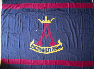 Brighton Historical Society
Flag, W. Morgan & Co, School flag, circa 1910s - 1930s
This flag was used by Rosbercon Girls Grammar School, which operated in Brighton from 1906 until 1941. The school was established in 1906 by the Tisdall family. The Tisdalls were a family of educators: Irish-born Henry Thomas Normanton Tisdall and his wife Lucy taught for many years at the Walhalla State School in Gippsland, along with Lucy's sisters Alice and Clara Weekes. Three of the Tisdall daughters, Ethel, Constance and Theodosia (Theo) followed their mother and aunts into the teaching profession. Constance in particular considered education her true calling and harboured a dream of one day being principal of her own school. After Henry's death in 1905, faced with financial uncertainty and several unmarried daughters to support, Lucy Tisdall decided to take a risk. She sold the family's Toorak home and, together with her sister Alice, leased 'Ashburnham', a large Victorian villa at 106 North Road, Brighton. The plan was to open a private school, with Ethel and Constance as co-principals and Lucy, Alice and Theo teaching and managing the household affairs. This came as a "joyful surprise" to Constance, who was only informed of the plan after it had been finalised. The school was named Rosbercon after Henry's home village in County Wexford, Ireland. The crest, designed by son Bert Tisdall around 1910, featured a crowned letter 'A' above the motto "amor vincit omnia" ("love conquers all"), both inspired by a verse in Geoffrey Chaucer's "The Prioress's Tale": "about her arm she bore/A paire of bedes gauded all in grene,/And theron heng a broche of gold full shene,/On which there was first writ a crowned 'A',/And after, Amor Vincit Omnia." It was a motto Constance held close to her heart, embodying her values as a teacher. Reflecting in 1961, she wrote, "In a school without punishments, a school with love and understanding between teacher and pupil - with a love of teaching on one side, and a desire to learn on the other, love would indeed conquer all." The school's opening day in 1906 proved less than auspicious, with no pupils arriving at all. The women persisted and by the end of the first week, five students had been enrolled. From here, the school grew steadily in size. A new schoolroom designed by architect Harold Desbrowe-Annear was built in the house's orchard to accommodate the increasing numbers, but by 1911 the Tisdalls began looking for larger premises. They leased the nearby property 'Hazeldean' at 124 North Road and, during the 1912 school holidays, the Desbrowe-Annear schoolroom was raised onto a lorry drawn by sixteen horses and moved down the road to what would become Rosbercon's new home. In 1923, Constance instituted a modified version of the Dalton Plan, an education model based on individualised learning. Girls in senior years were encouraged to work more independently, making regular use of the reference library and working to a monthly assignment schedule. The school performed well academically and in competitive sport, but over time was eclipsed by the nearby Firbank Church of England Girls' Grammar School (established 1909), whose institutional backing provided it with access to wider resources and facilities than those of the small family-run Rosbercon. At the end of 1933, Ethel and Theo retired and Constance became principal of St Anne's Church of England Girls' Grammar School (now Gippsland Grammar) in Sale. Rosbercon was sold to Miss Iris Hay, who served as principal from 1934 until the school's closure in 1941. Following her own retirement in 1947, Constance Tisdall settled in Erica Avenue, East Malvern, in a house named 'Rosbercon' after her former school. She continued teaching English literature, mostly to migrants, and enjoyed regular visits from former students. Well into the late 1960s, old Rosbercon girls continued a tradition of coming together for an annual reunion on the first Saturday in November, on which day Constance would fly the school flag at her home.Large navy blue flag with horizontal maroon stripe at top and bottom, and school crest in centre. Stylised maroon "A" topped with yellow crown. Yellow scroll below with motto in navy blue letters: "AMOR.VINCIT.OMNIA".flag, school flag, rosbercon girls grammar school -
 Bendigo Historical Society Inc.
Document - BROADCASTING STATION 3CV, MARYBOROUGH, 2 March, 1956
Broadcasting Station 3CV, Maryborough. A souvenir of the opening of the New Studios and Offices of Central Victoria Broadcasters Pty Ltd. March 2nd, 1956. Established 1956, offices in Burke Street, opening coincides with the stations 21st birthday, March 2 for the former celebration, October 26 for the latter. Coverage included Bendigo, Ballarat, Daylesford, Castlemaine and Maryborough. 3CV plays active part in assisting charities and hospitals at Maryborough, Daylesford, Maldon and Dunolly. Active Women's Radio Club with branches in country centres adds strength to station's charitable efforts. Opening 3CV's new premises will widen the scope of the station's charitable efforts, and stronger link with Australian Commercial Broadcasting stations. Writer Harold V Nunn writes history of district of Mayborough. Manager Ken J Parker, Central Victoria Broadcasters Pty. Ltd. The Souvenir brochure also covers topics such as: deep lead mining. WWI. Houses being pulled down. New settlements of Mildura. Secondary Industries. Bowenvale, Alma, Majorca, Craigie, Amherst, Adelaide Lead, Havelock, Bet Bet, Bently. Primary production and a railway staff of approximately 150. Maryborough a little town without a future. Coal fields at Wonthaggi. 1917 a public meeting was convened in an effort to stem the tide of adversity. Mayor George Frost, M.L.A., decision to form a Progress Association, a policy of secondary industry was decided upon and committees were appointed, James L Drew much credit is due. Maryborough's move for rejuvenation was revolutionary, because apart from Ballarat, Bendigo and Geelong, it was regarded as so much presumption that industry could be expected to function with success in a country town. Governments were unsympathetic. Maryborough & district people showed determination to succeed and their faith in their town. Employment and economic security provided by the industries outweighed the debt. Maryborough's general position is that it is no longer dependent upon one particular phase of activity. The first of the industries to be formed in 1918 was the Butter Factory. The nearer dairy companies did not take kindly to the prospect of another opposition company taking supplies from their districts, and in the first few years of establishment completion made the going hard for the management. But adopting a conservative policy and placing all profits to reserve I the first six years of operation headway was gradually made. Thus it was a red letter day for the company in 1925 when the first dividend of 5 percent was paid.1955 dividend of 10 per cent. Operating it's own trucks the dairy serviced local dairymen up to 40 miles. Maryborough Knitting mills est. 1923, having transferred from Clunes. Out bid Ballarat and Bendigo to the industry. The mill has what is probably the largest circular underwear plant in the Commonwealth, which is conservatively valued at 198,913 pounds. It produces between four and five million garments each year, worth over one million pounds. The company has established subsidiary mills at Dunolly, Talbot and Avoca. The company also assisted in the establishment of the Interknit Hosiery Co. Ltd., Clunes. The Maryborough Flour Mills is the second oldest of Mayborough's industries. It was built by Mr Cadwallader over 70 years ago. It was later sold to Mr. A Land and then to Jas. Minifie & Co. It had a somewhat 'in-and -out' existence until purchased in 1923 by Messrs. Willersdorf and Forbes, of Eddington. In 1939 the firm began to build silos for the storage of bulk wheat and the present storage capacity is 100,000 bushels. 1944 power was changed from steam to electricity. The mill has an out put of 20 sacks an hour. 1938 a chaff mill was built, and now is regarded as one of the best in Victoria. Its output in one year of approximately 6,800 tons is a State record for a single cutter. During this 30 year period Patience and Nicholson Limited has grown with Maryborough and is now one of the major key industries of Australia. The P&N brand covers precision tools - taps, dies and twist drills - indispensable to the country's economy, and quality is acknowledged equally by an air craft factory in Canada, a dockyard in Thailand, a railway workshop in New Zealand, no less than by our own Australian industries. Maryborough can be proud of the part played by P&N in war when, geared to the needs of the times, it poured countless millions of tools into defence factories and to the armed forces of the Allies, and now in peace when it is providing, hydro-electric undertakings and the manufacture of cars and tractors. From 1858, W Phelan & Sons Pty Ltd has made phenomenal and spectacular growth, becoming incorporated as a private company in 1929. It is without doubt the greatest private development in the history of Maryborough. 1940 joinery manufacture was commenced. The company entered the Ready Built Housing field in `950 - and in 1951 established a factory at Cairns, Northern Queensland to overcome the manufacturing difficulties being experienced due to the shortage of plywood in Victoria. Present activities include: Ready Built Housing Factory, on-site building, a modern joinery, timber yard, drying kilns, etc., and plumbing & electrical & engineering services, a door and panel factory at Cairns, retail hardware store, Melbourne Sales Depot. Hedges & Bell Pty Ltd were est 1945, with a staff of 40 employees are the largest printing firm outside the metropolitan area. The branch of Premier Wireworks is a contribution made by the decentralisation policy of the State.event, official, celebration, broadcasting station 3cv, maryborough. a souvenir of the opening of the new studios and offices of central victoria broadcasters pty ltd. march 2nd, 1956. established 1956, offices in burke street, 21st birthday. coverage bendigo, ballarat, daylesford, castlemaine maryborough. assisting charities and hospitals maldon and dunolly. women's radio club opening 3cv's new premises australian commercial broadcasting stations. writer harold v nunn writes history of district of mayborough. manager ken j parker, central victoria broadcasters pty. ltd. souvenir brochure: deep lead mining. wwi. houses pulled down. new settlements. primary production railway staff. coal fields wonthaggi. 1917 a public meeting was convened in an effort to stem the tide of adversity. mayor george frost, m.l.a., form a progress association, policy of secondary industry, james l drew rejuvenation was revolutionary, employment and economic security. the first of the industries to be formed in 1918 was the butter factory. thus it was a red letter day for the company in 1925 when the first dividend of 5 percent was paid.1955 dividend of 10 per cent. operating it's own trucks serviced local dairymen. maryborough knitting mills est. 1923 largest circular underwear plant in the commonwealth. established subsidiary mills at dunolly, talbot, avoca. interknit hosiery co. ltd., clunes. the maryborough flour mills it was built by mr cadwallader. mr. a land jas. minifie & co. messrs. willersdorf and forbes, build silos for wheat storage capacity is 100, 000 bushels. 1944 power was changed from steam to electricity. 20 sacks an hour. 1938 a chaff mill was built, best in victoria. patience and nicholson limited the p&n precision tools - taps, dies and twist drills. war, geared to the needs of the times, countless millions of tools into defence factories the armed forces of the allies, hydro-electric undertakings and the manufacture of cars and tractors. from 1858, w phelan & sons pty ltd, incorporated 1929. 1940 joinery manufacture. ready built housing field in 1950 - 1951 established a factory at cairns, northern queensland to overcome the manufacturing difficulties being experienced due to the shortage of plywood in victoria. present activities: ready built housing factory, on-site building, a modern joinery, timber yard, drying kilns, etc., and plumbing & electrical & engineering services, a door and panel factory at cairns, retail hardware store, melbourne sales depot. hedges & bell pty ltd were est. 1945, with a staff of 40 employees are the largest printing firm outside the metropolitan area. the branch of premier wireworks is a contribution made by the decentralisation policy of the state. -
 Flagstaff Hill Maritime Museum and Village
Instrument - Clock
This wall clock originated from the Bank of Australasia. The label on the base matches other items from the same donor. It was spring powered by winding the key mechanism with the clock's key through the hole in the clock face. The hinged door on the base of the clock's case allows access to the clock's working mechanism. James Murray (son of James Murray 1780-1847) was a maker of clocks and chronometers. He worked at No. 1, Royal Exchange, London and from 1861 at 107 Great Bourke Street, Melbourne. In 1854 William Kerr ordered a clock from James Murray and erected it on the Albert Street frontage of the National Model & Training School in Spring Street Melbourne. It was Melbourne's first turret clock and remained there for 80 years before it was transferred to the Public Library in Melbourne in 1934 (now Museum Victoria). The Bank of Australasia was incorporated by Royal Charter of England in March 1834. It had its Australian beginning on 14th December 1835, opening in Sydney. The Acting Superintendent of the bank at that time was David Charters McArthur. He was Superintendent from 1867-to 1876. The Melbourne branch opened on 28th August 1838 in a two-roomed brick cottage on the north side of Little Collins Street, where two huge mastiff dogs were used at night to guard the bank. The government also provided an armed military sentinel. Due to the bank's rapid growth, a new building for the Melbourne branch was opened in 1840 at 75 Collins Street West. By 1879 the bank had been upgraded to a magnificent two-storey building on the corners of Collins and Queens Streets, with the entry on Collins Street. In 1951 the Bank of Australasia amalgamated with the Union Bank to form the Australia and New Zealand Bank, now known as the ANZ. Then in 1970, the ANZ merged with both the ES&A and the London Bank of Australia to form the ANZ Banking Group Limited. The ANZ Banking Group Ltd kindly donated a variety of historic items from the Bank of Australasia. BANK of AUSTRALASIA, WARRNAMBOOL – In 1854 Warrnambool had two banks, the Union Bank and the Bank of Australasia. Later, completely different bank businesses opened; in 1867 the National Bank of Australasia, then in 1875 the Colonial Bank of Australasia. The original Warrnambool branch of the Bank of Australasia was established in July 1854, and operated from a leased cottage on Merri Street, close to Liebig Street. The bank next bought a stone building previously erected by drapers Cramond & Dickson on the corner of Timor and Gibson Streets. Samuel Hannaford was a teller and then Manager at the Warrnambool branch from 1855 to 1856 and the Warrnambool Council chose that bank for its dealings during 1856-57. In 1859 Roberts & Co. was awarded the contract to build the new Bank of Australasia branch for the sum of £3,000. The land was on a sand hill on the northeast corner of Timor and Kepler Streets and had been bought in 1855 from investor James Cust. The new building opened on May 21, 1860. The bank continued to operate there until 1951 when it merged with the Union Bank to form the ANZ Bank, which continued operating from its Liebig Street building. Warrnambool City Council purchased the former Bank of Australasia building in 1971 and renovated it, then on 3rd December 1973 it was officially opened as the Art Gallery by Cr. Harold Stephenson and Gallery Director John Welsh. The Gallery transferred to the purpose-built building in Liebig Street in 1986 and the old bank building is now the Gallery club. Staff at the Bank of Australasia in Warrnambool included the following men but others were also involved: Samuel Hannaford, Teller then Manager from 1855-1856; W H Palmer, Manager from January 1857 until November 1869 when the Teller Basil Spence was promoted to Manager; H B Chomley, Manager from April 1873 and still there in 1886; A Butt, Manager in 1895-1904; J R McCleary Accountant and Acting Manager for 12 months, until 1900; A Kirk, Manager 1904; J Moore, staff until his transfer to Bendigo in December 1908; J S Bath was Manager until 1915; C C Cox, Manager until April 1923; Richard C Stanley, Manager 1923 to April 1928. The clock has significance through its association with the Bank of Australasia. The early Australian bank was established in 1834 by Royal Charter and opened in Sydney, Australia, in Sydney in 1835. The bank had many Australian offices in November 1877, particularly on the east and south coasts. Victoria had 45 percent of all Offices. The clock is significant for its connection with the quality clockmaker James Murray, originally from Royal Exchange London with a branch that opened in Melbourne in 1861. James Murray is renown for making the first turret clock to be installed in Melbourne. The clock is locally significant for its association with the Warrnambool Bank of Australasia, which was established in 1854. It was Warrnambool Council’s first bank. The bank continued to operate until the organisation's merger in 1951 when it became the ANZ Bank Group today. The Bank was an integral part of the growth of local commerce and the community.Wall clock with a round face behind glass in a wooden case. The painted brass face has Roman numerals, two decorative hands, divisions for minutes and a keyhole. The curved base of the case has a hinged access door with a keyhole and adhesive label. The back of the clock's case has metal mounting brackets. Inscriptions on the rectangular white label. Made by James Murray, Melbourne.Face: "JAMES MURRAY / - GT. BOURKE ST. / MELBOURNE / & / ROYAL EXCHANGE / LONEON" Label: "A M / 40"flagstaff hill, warrnambool, shipwrecked coast, flagstaff hill maritime museum, maritime museum, shipwreck coast, flagstaff hill maritime village, great ocean road, bank of australasia, boa, union bank, australia & new zealand bank, anz bank, james murray, clock, wall clock, great bourke street melbourne, royal exchange london, william kerr, turret clock, old model school, national model & training school, access door, winding key -
 Flagstaff Hill Maritime Museum and Village
Container - Ink Bottle & Case, 1934 – Mid 1950’s
Pens, nib pens and later fountain pens, with suitable inks, were commonly used for writing communications from the 18th century to the mod 20th century. Fountain pens continue to be used and enjoyed. Dip pens with a wide variety of nibs are used for calligraphy writing, a hobby enjoyed by many people. The quality of the pen handle, the nib and the ink all work together to produce fine handwriting that expresses the character and mood of the writer. This Bakelite ink case has been specifically moulded to snugly contain an ink bottle, with just enough room to wrap the bottle with a padding or card or blotting paper. The screw top lid fits the case well and this container would be a good way to travel with ink because any spillage would be kept within the waterproof case. The Bakelite material is lightweight and strong. Ink bottle cases, or travelling cases, have been made as an accessory for nib pen writers. The first patent for a “pocket-case for bottles”, a wooden case, was applied for in the US in 1891. Other materials such as steel, pewter and aluminum as well as Bakelite have also been used. The British Museum has an elaborately decorated bronze ink pot holder that is inlaid with turquoise. Today ink bottle cases are even available in fabric with loops to attach to a belt. Bakelite, the material used for this ink bottle case, is made from synthetic materials and is an early form of plastic, developed in 1907 and used extensively until the 1940’s. It is still in used today for specific applications but has been largely replaced by more modern forms of plastics. This ink bottle case carries the imprint of Mabie, Todd & Co. (Aust.) Pty. Ltd. This form of company name was used from 1938 to the mid 1950’s. The Swan ink bottle’s information says it was made by Mabie, Todd & Co. Ltd., London and Sydney, so dates the ink bottle from about 1908 until 1934. (Australian newspapers display advertisements dated 1908 until 1934 for Sydney wholesalers and agents for Mabie, Todd & Co. Ltd.) ABOUT PERSONAL FOUNTAIN PENS (FOUNT PENS) A 1917 newspaper advertisement recommends that the owner of a “Swan” doesn’t lend it to anyone else to use due to its qualities of it personalised to the owner. It reads “Don’t lend your “Swan” fountpen, recommend it, but don’t let other people use it. You see, a good pen doesn’t wear, but its “tamper” (or spring) works into the writer’s pressure and manner of holding. Another person with a dashing style of writing may strain it do that it will no longer feel just like your own.” This personalisation of nib pens may be the reason that legal documents in the past being acceptable only if they were signed using a ‘wet ink’ pen. Forgeries of signatures could be easily detected as the nib takes on the character of the pen’s owner. A ballpoint pen was not acceptable. This is a strong contrast to modern times when a digital signature is widely accepted. ABOUT MABIE TODD Pty Ltd. The American company Mabie Todd began by making pencil cases in New York in the 1860’s. The Bard Brothers, makers of Gold nibs, joined Mabie Todd and the company was established in the 1870’s as Mabie Todd and Bard. In 1878 the company filed a patent for the design of a fountain pen and in 1884 the first Swan fountain pen was released. In 1884 a Mabie Todd and Bard office and showroom was established in London. In 1906 the company’s name changed to Mabie Todd & Co, New York. The UK offices also used this new name and in 1907 the UK began producing their own Swan pens. Manufacturing was going so well in England that New York sold their rights to European and Colonial business to the new Mabie Todd & Company Ltd of England. By the end of the 1930’s all components for the pens were being made in the UK; the pens in the London factory, the gold nibs in Birmingham and the ink in Liverpool. Newspaper articles from 1934 stated that Mabie Todd were large buyers of Tasmanian iridium, which had been welded with gold and used since 1834 for the tips of nib and fountain pens. Fountain pen points were the largest market buyers for Tasmanian iridium, which was classed as “the best in the world”. Production growth continued up until WWII times, when the headquarters and main factory were destroyed. Mabie Todd & Company Ltd of England rebuilt out of the inner city and by 1946 pen production began again. The market for nib and fountain pens was diminishing by this time, with people beginning to use the new ballpoint ‘Biro’ pens. The Mabie Todd bought shares in Biro Pens and in 1952 became Biro Swan. They went on to make more ballpoint pens than any other manufacturer in Britain. The ink refills that Biro-Swan produced came in five different viscosity or thickness xhoices, depending on the season and location of where the pen would be used . Along with the ballpoint pens, Biro-Swan also introduced a range of Calligraph pens to attract those following the new trend for italic writing. In 1948 Mr. T. Burke, a director for Mabie Todd & Co. (Aust.) Pty Ltd., announced that there would be a £40,000 factory built in Sydney in 1949 for the manufacture of ink. The plant for the factory would be imported from overseas. Sadly the company struggled against competition and in 1956 Mabie Todd closed business and no more Swan pens were produced. The ink bottle and container was donated to Flagstaff Hill Maritime Village by the family of Doctor William Roy Angus, Surgeon and Oculist. It is part of the “W.R. Angus Collection” includes historical medical equipment, surgical instruments and material once belonging to Dr Edward Ryan and Dr Thomas Francis Ryan, (both of Nhill, Victoria) as well as Dr Angus’ own belongings. The Collection’s history spans the medical practices of the two Doctors Ryan, from 1885-1926 plus that of Dr Angus, up until 1969. ABOUT THE “W.R.ANGUS COLLECTION” Doctor William Roy Angus M.B., B.S., Adel., 1923, F.R.C.S. Edin.,1928 (also known as Dr Roy Angus) was born in Murrumbeena, Victoria in 1901 and lived until 1970. He qualified as a doctor in 1923 at University of Adelaide, was Resident Medical Officer at the Royal Adelaide Hospital in 1924 and for a period was house surgeon to Sir (then Mr.) Henry Simpson Newland. Dr Angus was briefly an Assistant to Dr Riddell of Kapunda, then commenced private practice at Curramulka, Yorke Peninsula, SA, where he was physician, surgeon and chemist. In 1926, he was appointed as new Medical Assistant to Dr Thomas Francis Ryan (T.F. Ryan, or Tom), in Nhill, Victoria, where his experiences included radiology and pharmacy. In 1927 he was Acting House Surgeon in Dr Tom Ryan’s absence. Dr Angus had become engaged to Gladys Forsyth and they decided he further his studies overseas in the UK in 1927. He studied at London University College Hospital and at Edinburgh Royal Infirmary and in 1928, was awarded FRCS (Fellow from the Royal College of Surgeons), Edinburgh. He worked his passage back to Australia as a Ship’s Surgeon on the on the Australian Commonwealth Line’s T.S.S. Largs Bay. Dr Angus married Gladys in 1929, in Ballarat. (They went on to have one son (Graham 1932, born in SA) and two daughters (Helen (died 12/07/1996) and Berenice (Berry), both born at Mira, Nhill ) According to Berry, her mother Gladys made a lot of their clothes. She was very talented and did some lovely embroidery including lingerie for her trousseau and beautifully handmade baby clothes. Dr Angus was a ‘flying doctor’ for the A.I.M. (Australian Inland Ministry) Aerial Medical Service in 1928 . Its first station was in the remote town of Oodnadatta, where Dr Angus was stationed. He was locum tenens there on North-South Railway at 21 Mile Camp. He took up this ‘flying doctor’ position in response to a call from Dr John Flynn; the organisation was later known as the Flying Doctor Service, then the Royal Flying Doctor Service. A lot of his work during this time involved dental surgery also. Between 1928-1932 he was surgeon at the Curramulka Hospital, Yorke Peninsula, South Australia. In 1933 Dr Angus returned to Nhill and purchased a share of the Nelson Street practice and Mira hospital (a 2 bed ward at the Nelson Street Practice) from Dr Les Middleton one of the Middleton Brothers, the current owners of what previously once Dr Tom Ryan’s practice. Dr Tom and his brother had worked as surgeons included eye surgery. Dr Tom Ryan performed many of his operations in the Mira private hospital on his premises. He had been House Surgeon at the Nhill Hospital 1902-1926. Dr Tom Ryan had one of the only two pieces of radiology equipment in Victoria during his practicing years – The Royal Melbourne Hospital had the other one. Over the years Dr Tom Ryan had gradually set up what was effectively a training school for country general-practitioner-surgeons. Each patient was carefully examined, including using the X-ray machine, and any surgery was discussed and planned with Dr Ryan’s assistants several days in advance. Dr Angus gained experience in using the X-ray machine there during his time as assistant to Dr Ryan. When Dr Angus bought into the Nelson Street premises in Nhill he was also appointed as the Nhill Hospital’s Honorary House Surgeon 1933-1938. His practitioner’s plate from his Nhill surgery is now mounted on the doorway to the Port Medical Office at Flagstaff Hill Maritime Village, Warrnambool. When Dr Angus took up practice in the Dr Edward and Dr Tom Ryan’s old premises he obtained their extensive collection of historical medical equipment and materials spanning 1884-1926. A large part of this collection is now on display at the Port Medical Office at Flagstaff Hill Maritime Village in Warrnambool. In 1939 Dr Angus and his family moved to Warrnambool where he purchased “Birchwood,” the 1852 home and medical practice of Dr John Hunter Henderson, at 214 Koroit Street. (This property was sold in1965 to the State Government and is now the site of the Warrnambool Police Station. and an ALDI sore is on the land that was once their tennis court). The Angus family was able to afford gardeners, cooks and maids; their home was a popular place for visiting dignitaries to stay whilst visiting Warrnambool. Dr Angus had his own silk worm farm at home in a Mulberry tree. His young daughter used his centrifuge for spinning the silk. Dr Angus was appointed on a part-time basis as Port Medical Officer (Health Officer) in Warrnambool and held this position until the 1940’s when the government no longer required the service of a Port Medical Officer in Warrnambool; he was thus Warrnambool’s last serving Port Medical Officer. (Masters of immigrant ships arriving in port reported incidents of diseases, illness and death and the Port Medical Officer made a decision on whether the ship required Quarantine and for how long, in this way preventing contagious illness from spreading from new immigrants to the residents already in the colony.) Dr Angus was a member of the Australian Medical Association, for 35 years and surgeon at the Warrnambool Base Hospital 1939-1942, He served with the Australian Department of Defence as a Surgeon Captain during WWII 1942-45, in Ballarat, Victoria, and in Bonegilla, N.S.W., completing his service just before the end of the war due to suffering from a heart attack. During his convalescence he carved an intricate and ‘most artistic’ chess set from the material that dentures were made from. He then studied ophthalmology at the Royal Melbourne Eye and Ear Hospital and created cosmetically superior artificial eyes by pioneering using the intrascleral cartilage. Angus received accolades from the Ophthalmological Society of Australasia for this work. He returned to Warrnambool to commence practice as an ophthalmologist, pioneering in artificial eye improvements. He was Honorary Consultant Ophthalmologist to Warrnambool Base Hospital for 31 years. He made monthly visits to Portland as a visiting surgeon, to perform eye surgery. He represented the Victorian South-West subdivision of the Australian Medical Association as its secretary between 1949 and 1956 and as chairman from 1956 to 1958. In 1968 Dr Angus was elected member of Spain’s Barraquer Institute of Barcelona after his research work in Intrasclearal cartilage grafting, becoming one of the few Australian ophthalmologists to receive this honour, and in the following year presented his final paper on Living Intrasclearal Cartilage Implants at the Inaugural Meeting of the Australian College of Ophthalmologists in Melbourne In his personal life Dr Angus was a Presbyterian and treated Sunday as a Sabbath, a day of rest. He would visit 3 or 4 country patients on a Sunday, taking his children along ‘for the ride’ and to visit with him. Sunday evenings he would play the pianola and sing Scottish songs to his family. One of Dr Angus’ patients was Margaret MacKenzie, author of a book on local shipwrecks that she’d seen as an eye witness from the late 1880’s in Peterborough, Victoria. In the early 1950’s Dr Angus, painted a picture of a shipwreck for the cover jacket of Margaret’s book, Shipwrecks and More Shipwrecks. She was blind in later life and her daughter wrote the actual book for her. Dr Angus and his wife Gladys were very involved in Warrnambool’s society with a strong interest in civic affairs. He had an interest in people and the community They were both involved in the creation of Flagstaff Hill, including the layout of the gardens. After his death (28th March 1970) his family requested his practitioner’s plate, medical instruments and some personal belongings be displayed in the Port Medical Office surgery at Flagstaff Hill Maritime Village, and be called the “W. R. Angus Collection”. The ink bottle case is significant for its association with writing methods commonly used during the colonisation of Australia until the mid-20th century. The protective Bakelite case demonstrates the value placed on caring for the user’s supply of ink and protecting other belongings of the user, enabling writers to easily carry and safely transport their ink without the concern of spilling it. The case’s design is a good example of the use of new technology. The properties of Bakelite have enabled its moulded design and make it waterproof and lightweight, easily cleaned, closely fitted to the shape of the ink bottle within and lid and base join together using a smooth screwing action. The maker’s marks have also been moulded into the Bakelite, therefore not distracting from the simple but elegant design. This ink bottle case also represents the period of early to mid-20th century when handwriting materials for writers using ink and nib pens were imported into Australia and developed for the Australian market and sold by wholesalers on behalf of overseas companies. Vintage brown Bakelite travelling ink bottle case (or holder, pot, well) containing glass ink bottle and original textured cardboard liner, made by Swan Ink, Mabie, Todd & Co. (Aust) Pty.. Ltd. The Bakelite container is shaped to fit snugly around the ink bottle. It still retains its original shiny finish, the lid screws on and off perfectly. The maker’s name is embossed on lid and base of the Bakelite container. The inkwell contains a glass Ink bottle with a tiny amount of dried up ink Swan triple filtered ink inside. The bottle is cylindrical with curved shoulders tapering to a neck of around 2cm. The white metal screw-on lid and the white and red paper label on the side of the bottle both have a printed description of the ink and maker. Circa 1934-1950’sBAKELITE INK CASE - embossed on either side of the lid “ “SWAN” INK / ”SWAN” INK “ - embossed into base, written in a circle “MABIE TODD & Co (Aust.) PTY. LTD.” GLASS BOTTLE – printed on lid “SWAN”/ [corporate logo combining letters ‘M, T, co’]/TRIPLE FILTERED/ INK.” - printed on label “SWAN” INK /FOR FOUNTAIN & / STEEL PENS / A BLUE BLACK INK OF/ THE FINEST QUALITY/ MADE IN ENGLAND/ MABIE. TODD & CO LTD …….. LONDON. SYDNEY/ Makers of “SWAN” Pens, Gold Pens & Ink“ - moulded into the base of the ink bottle and written around the bottom outside edge of the bottle are the words “THIS BOTTLE ALWAYS REMAINS THE PROPERTY OF/ MABIE TODD/AUST”flagstaff hill, warrnambool, shipwrecked coast, flagstaff hill maritime museum, maritime museum, shipwreck coast, flagstaff hill maritime village, great ocean road, ink bottle holder, ink bottle case, ink bottle pot, travelling inkwell, portable inkwell, travelling ink pot, travelling ink bottle case, ink bottle, inkwell, ink well, swan ink, bakelite, dip pen ink, nib pen ink, fountain pen, fontpen, writing methods, stationery, mabie todd & co, swan fountain pens, biro-swan -
 Flagstaff Hill Maritime Museum and Village
Instrument - Optical, Binoculars, 1878 (estimated)
This pair of brass binoculars was presented to Tom Pearce in recognition of his heroic efforts at the wrecking of the Loch Ard and saving Eva Carmichael. They were presented to him by the Lady Mayoress of Sydney on 27th July 1878 on behalf of the colonists of New South Wales "In recognition of his gallant conduct on the occasion of the wreck of the Loch Ard". Tom (Thomas) Pearce was born in Ireland in 1859 and arrived in Melbourne two years later; he considered himself as Australian. Before sailing on the Loch Ard he had been at sea for three years as an apprentice sailor and had already experienced one shipwreck. Tom was on the deck of the Loch Ard with Captain Gibb throughout the night of May 31st 1878. It was mistakenly thought they were 150 miles (240 km) southwest of Cape Otway. By 2:00 am on June 1st, the wind was blowing "pretty fresh" but a thick haze remained and, when it eventually cleared, the land was so close the unsuccessful battle to save the Loch Ard began. After the ship struck Mutton Bird Island Tom and five others were sent to the lifeboats. Conditions were very dangerous as waves broke over the decks and they were all washed away. Tom found himself in the stormy waters and under a lifeboat, which had also been washed into the sea. After being swept into the gorge Tom left the boat and swam into shore; he was alone. Eva Carmichael, a passenger on the ship, had been snatched from her bed just before dawn and into the chaos, confusion and terror of the shipwreck, with rigging and rocks raining down. Thrown into the sea, she afterwards said: "God taught me to swim in my distressful plight, for I never swam before". Clinging to a spar, she was swept into the gorge and saw Tom Pearce walking along the beach. Upon hearing the cries of Eva, Tom swam out and with great difficulty brought her to the shore and placed her safely in a cave where he made a bed of grass and shrubs and gave her brandy to revive her. She sank into exhausted unconsciousness. Tom then scrambled to the top of the high cliff and after walking for some time he stumbled upon workers from Glenample Homestead. They rode back to the homestead for help but Tom insisted on returning to Eva. When Eva awoke she found herself alone, "cold, weak and terrified with the wild waves before me, and caves and cliffs around me" and upon hearing strange noises, which she imagined to be made by the local indigenous people, she hid. The noises were made by the rescue party from Glenample Homestead. After eventually discovering Eva they hauled her up the cliff in the darkness of night, “a work of great difficulty and danger” and took her to Glenample. Sadly, Tom and Eva were the only survivors of the 54 people on board the Loch Ard. Tom’s rewards for his bravery included the Gold Medal of the Humane Society, a gold watch and £1000 from the Victorian Government, a set of nautical instruments, (which included the binoculars) from the people of Sydney and £60 from the people of Warrnambool. He was also presented with a Bible by a “Friend of the Loyal Orange Institution of Victoria, Protestant Hall Melbourne” in August 1878. Coleman Jacobs composed the music "The Young Hero Schottische" and dedicated it, by permission, to Mr Thomas R. (Tom) Pearce. The sheet music was published in 1878 by Mr Roberts, professor of dancing and was on sale for 3/- (3 shillings) in aid of the "Loch Ard" fund. Tom Pearce went on to join the Loch Sunart on her return to England, only to be wrecked again off the Irish coast in January 1879. Tom left the Loch Line in 1883 and the following year married Edith Gurney Strasenbergh, the sister of his friend Robert who had died on the Loch Ard. They had three children, unfortunately, two of the male children were to die at sea. In 1895 Tom obtained his first command as Master of The Larne, a vessel with the Royal Mail Steam Packet Company. He remained with the company until he died in Southampton, England, on 14th December 1908. Tom Pearce never saw Eva Carmichael after he had fare welled her some 30 years before. Eveline Victoria Berta Carmichael was born in 1859 in Mountrath, Queens County, Ireland. After recovering from her ordeal in August 1878 Eva returned to Ireland and in 1884 married Thomas Achilles Townshend, a Civil Engineer. They had three sons, all of whom had successful military careers, and when Eva’s death notice appeared in the Melbourne Argus It read. "Townshend on 8th April 1934 aged 74 at her residence in Bedford, England, Evaline Victoria, widow of the late Thomas Archilles Townshend, C.E. of Co. Cork, Ireland. Mrs Townshend was the Eva Carmichael who, with the late Tom Pearce, were the only two survivors of the ship Loch Ard, which was wrecked near Port Campbell on June 1st 1878." The binoculars are significant for their association with the wreck of the Loch Ard and the only two surviving members of that wreck Tom Pearce and Eva Carmichael. Flagstaff Hill’s collection of artefacts from Loch Ard is significant for being one of the largest. The shipwreck of the Loch Ard is of significance for Victoria and is registered on the Victorian Heritage Register ( S 417). Flagstaff Hill has a varied collection of artefacts from Loch Ard and its collection is significant for being one of the largest accumulation of artefacts from this notable Victorian shipwreck. The collections object is to also give us a snapshot into history so we can interpret the story of this tragic event. The collection is also archaeologically significant as it represents aspects of Victoria's shipping history that allows us to interpret Victoria's social and historical themes of the time. The assemblage of items from the wreck is of historical significance in that they are associated with the worst and best-known shipwreck in Victoria's history. Pair of brass marine binoculars in a wooden box On the left hand eye piece, on the underside, is an engraved inscription and another engraved word. On the right hand eye piece there is another small inscription and on the underside there is a small green mark. The binoculars have a pattern of embossed tiny circles on the outside. Some of the patterning is very shiny due to wear and rubbing, there is a brass ring on the underside of the binoculars for the attachment of a lanyard. The wooden box has a hinged lid and on the front of the box in the centre is a lock, and at either end are two hooks and eyes. The box is split across the top for about 3/4 of the length. Marking on the left underside reads, 'Presented on behalf of the Colonists of New South Wales By the Mayoress of Sydney on 27th. July 1878 to Mr Thomas B Pearce. In recognition of his gallant conduct on the occasion of the wreck of the "Loch Ard"'. Underneath this inscription is engraved 'Sydney'. On the other eye piece is engraved what looks like 'Mac Donnell & Co' binoculars, flagstaff hill, warrnambool, shipwrecked coast, flagstaff hill maritime museum, maritime museum, shipwreck coast, flagstaff hill maritime village, loch ard shipwreck, tom pearce, thomas r pearce, eva carmichael, mutton bird island, loch ard survivor, loch ard hero, coleman jacobs, the young hero schottische, photograph of tom pearce, glenample homestead -
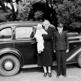 Melton City Libraries
Photograph, Ian and Wendy with Grandma Barrie, c.1943
Jessie May born on 30th November 1883, Jessie, known as Ma Barrie to her grandchildren, was the daughter of schoolteacher, Thomas John Lang and Mary Elizabeth Coates. In 1896 Thomas and Mary Elizabeth moved to Melton. Mr Lang’s previous school was Coliban SS No 1920. Mr Lang was the Head Teacher at Melton until 1917. In 1910 he was a Committee Member Melton Mechanics Institute and Public Library at its establishment. He was a Life Member of the Melton Mechanics Institute Jessie lived in various locations around Central Victoria, particularly Pastoria and Melton. When her father was Head Teacher at Melton State School no 430, she met her future husband, Charles Ernest Barrie. The couple were married at the Methodist Church Melton on the 23rd August in 1906. They lived in the newly built house beside the Chaff Mill on the corner of Station and Brooklyn Road Melton South. Their eldest child was Mary Ena was born on the 7th of October 1907. IN 1909, Ernest Wesley (Bonnie) was born 29th April (Ascot Vale). In 1910 the family moved to a farm in Trundle NSW. The Chaff Mill was sold to Glover Onians – HSK Ward. Later the original mill was burnt and replaced, and in 1977 a fire destroyed it again and it was not rebuilt. In 1911, the family returned to Melton buying the “Darlingsford” farm in May. The weather was too at Trundle for Jessie. Their address was Elizabeth Street Moonee Ponds. William Cecil was born on the 23rd of February 1912 and Charles Edgar was born on 1st June 1913. In 1916 they lived in Moonee Ponds where the children attend Bank Street School, Ascot Vale. The children developed diphtheria Mary and Bon were transferred to Fairfield Hospital. March 1919 the family returned to live at Melton at the time of the outbreak of the Spanish influenza. Mary, Bon, and Edgar returned to Melton School. Following the death of CEB in a car accident in 1931 she was left to bring up her children on her own; the youngest Jim, aged 9 and eldest Mary, aged 24. Jessie left ‘Darlingsford’ in 1946 when her sons had safely returned from WW II. She stayed at Yarram for a time where her married twin daughters lived when more grandchildren were born and spent the remainder of her life living with various family members. SUMMARY - Dr Ian Robinson OAM Born 26th June 1931 Parents – Keith John Robinson of “Creighton” Melton Mary nee Barrie of “Darlingsford” Melton The family lived at “Heatherdale” Toolern Vale. Their 3 children, Ian the first followed by daughters, Ena May and Mary Elizabeth (Beth) Ian and Ena attended Toolern Vale State School. No 946 The family later moved to Columban Ave Strathmore. During 1942 the children stayed their grandmother’s house at “Darlingsford” Melton. They enrolled at Melton State School No 430 on the 13/3/42 after attending State School No 483 Raleigh Street Essendon. They left Melton School on the 31/7/42 returning to Essendon. Ian attended Geelong College as a boarder after completing his schooling he entered University to study Medicine. His early General Practice was in Melbourne. In 1972 he joined the Royal Flying Doctor at Mount Isa, North West Region of Queensland. The region covered an area larger than the British Isles. He was on call 24 hours for emergencies. He spent three weeks away with calls and in the fourth week attended Aboriginal Reserves. Ian took two Queensland Governors and their wives to spend three nights at the Clinic. Sir Colin and Lady Hannah are still their friends. Area Co-ordinator Ian was awarded the Royal Humane Society Medal along with his pilot when they risked their lives landing on flooded land to save a patient. Ian remained a loyal contributor to the Royal Flying Doctor Service until 1997 He met Queen Elizabeth 2nd in Cairns, and also met Prince Phillip and Prince Andrew in Brisbane. Townsville – Locum Beenleigh – General Practice Open 7 Days 198? -2002 Aspects of his work covered the following – Police Work State Commonwealth Medical Officer TEYS COMPANY Q FEVER. Q Fever presents with flu like symptoms. The 1st Test always came back Negative BUT 2nd Test always positive. Ian lectured other Medicos re Q Fever Council Immunization in schools Covered boxing bouts Large Practice In 2002 Ian retired but continued house calls for older patients. Information from Anne to Beth received by Wendy October 2013 Wendy Elizabeth Barrie Jessie May Lang [Barrie] and Ian Keith Robinson standing in front of a carlocal identities -
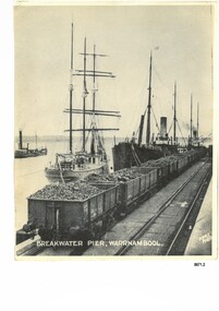 Flagstaff Hill Maritime Museum and Village
Photograph - Vessels at Breakwater Pier, Warrnambool, Foyle Photographic Studio, circa 1906
This photograph was one of ten photographs donated to Flagstaff Hill Maritime Museum and Village by Fred Trewartha. Frederick John Fox Trewartha (Fred) was a well-known Warrnambool businessman. He was born in Beeac near Geelong in 1920 and came to Warrnambool with his family as a very young child. He was apprenticed to his father John, as a saddler and later opened his own shop on Raglan Parade. He then moved into working with tarpaulins and canvases for the trucking industry. Fred was keenly interested in photography (and was a member of the Warrnambool Cine Club), yachting and boat building. He kept his yacht moored at Port Fairy for many years and participated in sailing events locally and interstate. He also built boats with his sons. He had the opportunity to meet many older sailors and it's thought this photo (and others in the set) may have been given to him by one of these men. Fred Trewartha died in 2016 in Warrnambool. The three identifiable ships in this picture are the "Speculant", the "S. S. Barrabool" and the "S. S. Flinders" - coastal trading vessels that regularly came and went from Warrnambool. The steamer on the left hasn't been identified. The barquentine SPECULANT was a steel, three-masted sailing ship built in 1895 in Inverkeithing, Scotland, registered in Warrnambool, Victoria and wrecked at Cape Paton, Victoria, 10th February 1911. The SPECULANT had been involved in the timber trade between the United Kingdom and Russia, until sold to its Warrnambool owners and timber merchants Messrs. P.J. McGennan & Co. (Peter John McGennan) in 1902 for 3000 pounds and had her sailed to Warrnambool as her new port. Peter John McGennan was born in 1844 and worked as a builder and cooper in Holyhead, Anglesea, Wales. He immigrated to Australia in 1869 as a free settler and arrived in Warrnambool in 1871 and undertook management of a property in Grassmere for Mr. Palmer. Peter met his wife Emily in South Melbourne and they married in 1873. They had ten children including Harry who lived to 1965, and Andrew who lived until 1958. (The other children were their four brothers - John who was killed in the Dardenalles aged 35, Frederick who died aged 8, Peter who died aged 28, Frank who died aged 5 weeks - and four sisters - Beatrice who died age 89, Edith who died aged 49, Blanche who died aged 89 and Eveline who died aged 48.) In 1874 Peter starting a boating establishment on the Hopkins River. In 1875 he opened up a Coopers business in Kepler Street next to what was Bateman, Smith and Co., moving to Liebig Street, next to the Victoria Hotel, in 1877. In 1882 he then moved to Lava Street (which in later years was the site of Chandlers Hardware Store). He was associated with the establishment of the Butter Factory at Allansford. He started making Butter Boxes to his own design and cheese batts for the Butter Factory. In 1896 established a Box Factory in Davis Street Merrivale, employing 24 people at its peak, (it was burnt down in 1923); and in Pertobe Road from 1912 (now the Army Barracks building). Peter was a Borough Councillor for Albert Ward from 1885 to 1891, he commenced the Foreshore Trust (including the camping grounds along Pertobe Road), and he was an inaugural Director of the Woollen Mill in Harris Street, buying an extensive share-holding in 1908 from the share trader Edward Vidler. They lobbied the Town Hall to have a formal ‘Cutting’ for the waters of the Merri River to be redirected from its natural opening south of Dennington, to its existing opening near Viaduct Road, in order to have the scourings from the wool at the Woollen Mill discharged into the sea. He sold Butter Boxes around the state, and had to ship them to Melbourne by rail. Peter’s purchase of the SPECULANT in 1902 enabled him to back-load white pine from Kaipara, New Zealand to Warrnambool to make his butter boxes then, to gain profitability, buy and ship potatoes and other primary produce bound to Melbourne. (McGennan & Co. had also owned the LA BELLA, which had traded in timber as well, until she was tragically wrecked with the loss of seven lives, after missing the entrance channel to Warrnambool harbour in 1905. It appears that the SPECULANT was bought to replace the LA BELLA.) In 1911 the SPECULANT had been attempting to depart Warrnambool for almost the entire month of January to undergo docking and overhaul in Melbourne. A month of east and south-easterly winds had forced her to remain sheltered in Lady Bay, Warrnambool apart from one morning of northerlies, when an attempt was made to round Cape Otway; she had to return to shelter in Portland after failing to make any headway. With only 140 tons of sand ballast aboard, the ship would not have been easy to handle. Captain Jacobsen and his crew of nine, mainly Swedes, decided to make for Melbourne, leaving Portland Harbour on 5th February 1911. By the 9th they had reached Cape Otway, where they encountered a moonless night, constant heavy rain, and a heavy sea with a south-easterly wind blowing. After safely rounding Cape Otway the course was changed to east, then north-east to take the vessel to a point six miles off Cape Patton, following the orders of Captain Jacobsen, who told the crew to be very careful with the steering, as the wind and sea was running to leeward. The patent log (used to measure speed) had been out of order for the last four months as no-one in Warrnambool was able to fix it: it was intended to have it repaired in Melbourne. In the meantime the crew measured the vessel's speed by looking over the side and estimating wind strength. This compounded the difficulties of imprecise positioning, as the strong cross wind and sea were acting on the lightly laden vessel to steadily drive it towards the shore. At 3.30am on Friday 10 February 1911 Captain Jacobsen and the first mate were looking over the side of the vessel when they heard the sound of breakers and suddenly struck the rocks. The crew immediately knew they had no chance of getting the SPECULANT off, and attempted to rescue themselves by launching the lifeboat, which was instantly smashed to pieces. One of the crew then volunteered to take a line ashore, and the rest of the crew were all able to drag themselves to shore, some suffering hand lacerations from the rocks. Once ashore they began to walk along the coast towards Lorne, believing it was the nearest settlement. Realising their mistake as dawn broke they returned westwards to Cape Patton, and found a farm belonging to Mr C. Ramsden, who took them in and gave them a change of clothes and food. After resting for a day and returning to the wreck to salvage some of their personal possessions, at 10am on Saturday they set out for Apollo Bay, a voyage that took six hours, sometimes wading through flooded creeks up to their necks. The Age described the wreck as "listed to starboard. All the cabin is gutted and the ballast gone. There is a big rock right through the bottom of her, and there is not the slightest hope of getting her off". A Board of Marine inquiry found that Captain Jacobson was guilty of careless navigation by not taking steps to accurately verify the position of the vessel with respect to Cape Otway when the light was visible and by not setting a safe and proper course with respect to the wind and sea. It suspended his certificate for 6 months and ordered him to pay costs. The location of the wreck site was marked for a long time by two anchors on the shoreline, until in 1970 the larger of the two anchors was recovered by the Underwater Explorers' Club and mounted on the foreshore at Apollo Bay. The bell from the wreck was also donated to the Apollo Bay Surf Lifesaving Club but is recorded to have been stolen. Rusting remains of the wreck can still be found on the shoreline on the southern side of, and directly below Cape Patton. Parts of the SPECULANT site have been buried by rubble from construction and maintenance works to the Great Ocean Road, as well as by naturally occurring landslides. Peter J McGennan passed away in 1920. The Gates in the western wall of the Anglican Church in Henna Street/Koroit St are dedicated to him for his time of community work, which is matched with other prominent Warrnambool citizens; Fletcher Jones, John Younger, J.D.E (Tag) Walter, and Edward Vidler. After Peter J McGennan's death Harry, Andrew and Edith continued to operate the family business until July 11th 1923 when the company was wound up. (Andrew lived in Ryot Street Warrnambool, near Lava Street.) Harry McGennan (Peter and Emily’s son) owned the Criterion Hotel in Kepler Street Warrnambool (now demolished). His son Sid and wife Dot lived in 28 Howard Street (corner of Nelson Street) and Sid managed the Criterion until it was decided by the family to sell, and for he remained Manager for the new owners until he retired. Harry commenced the Foreshore Trust in Warrnambool around 1950. The McGennan Carpark in Pertobe Road is named after Harry and there are Memorial-Stone Gates in his memory. (The Gates were once the original entrance to the carpark but are now the exit.). The Patent Log (also called a Taffrail log) from the SPECULANT, mentioned above, and a number of photographs, are now part of the Collection at Flagstaff Hill Maritime Village.. The S. S. Flinders was built by A. J. Inglis, Ltd, Pointhouse, Glasgow in 1878 for the "Tasmanian Steam Navigation Company', Hobart which merged with the "Union Steamship Company" of New Zealand and it was later sold to the firm "McIlwraith, McEacham and Company". It was built of iron and was 1000 tons and 227 feet, 1 inch long. It was described as "splendidly fitted up for the carriage of passengers and her cargo space was also very large". In the saloon about 130 passengers could be accommodated while the second class had sufficient room for one hundred passengers. In 1890, the S. S. Flinders would leave Melbourne on Mondays and Thursdays at 5 pm and reach Warrnambool the following morning at 8 am. On the return it would leave Warrnambool on Wednesdays and Saturdays at 5 pm and reach Melbourne the following morning. In 1896, the Weekly Times described the "steamer Flinders (otherwise known as "the Warrnambool mailboat") as "as good a sample of a seagoing steamer as there is trading on the Victorian Coast at the present time". In April 1896 newspaper reports noted the S. S. Flinders took 2915 bags of potatoes from Warrnambool to Melbourne (the largest shipment of that season) as well as 50 tons of tinned rabbits from the Hamilton Preserving Factory. It was also noted that particularly during the Christmas period, there were excessive demands for berths from holiday makers wanting to enjoy a holiday in Warrnambool. In May 1903, the S. S. Flinders narrowly escaped destruction when an explosion and subsequent fire occurred during the passage from Melbourne to Warrnambool. A drum (which apparently contained carbide of calcium) exploded and blew off a hatch cover. As the steamer got to within a mile or two of Warrnambool, smoke was seen coming out of the hold and (unknown to the passengers) flames had taken hold. The crew quickly got to work - closing down all the hatches and pumping water into the hold through a hole in the saloon floor. There were 30 or 40 cases of kerosene on board. The Flinders continued on to Warrnambool and berthed at the Breakwater. The passengers all went ashore - many unaware of the danger they had been in. A telephone message was sent to the local Fire Brigade Station however the fire was extinguished before the firemen and their equipment arrived. After the hold was checked, the Flinders was certified as seaworthy and left for Portland. The Flinders continued to transport Western District produce as well as passengers from Warrnambool to Melbourne until 1906 when (due to a decrease in shipping trade during the Winter and the availability of train services) the Flinders was replaced by the smaller steamer "Dawn" and in 1907 when it was sold to the "Adelaide Steamship Company" for use in the Western Australia coastal trade, it was replaced by the "S. S. Barrabool". The S. S. Barrabool was a coastal steamer built by "Palmer Shipbuilding and Iron Company Limited" in Jarrow, Durham in 1874. It was bought by "Howard Smith Ltd" who was a pioneer in the coal trade between Melbourne and Newcastle. Howards Smith's early fleet contained ships named after local hills and mountains -"You Yangs", "Macedon", "Dandenongs" and "Barrabool". Later they extended their fleet to include ships that were well known in Warrnambool including the "Dawn" and the "Edina". The S. S. Barrabool had a chequered start and was nicknamed the "Great Australian Ram" because of the numerous accidents it was involved in. Between 1875 and 1883 it collided with three other vessels - sinking the "Queensland" on August 3rd, 1876, near Wilson's Promontory and sinking the "Bonnie Dundee" on 10th March 1879 off Lake Macquarie, New South Wales (with the loss of five lives). In August 1884 the Barrabool collided with the steamer "Birksgate" in Port Jackson causing considerable damage to "Birksgate". However in a newspaper article published in the "Truth" in March 1899 the S. S. Barrabool was described as "one of the fine old type of vessels" and "still a stout a craft as ever". The article was describing the practice of a "two-mate" system on board many ships (the Barrabool being one) whereby the company only employs two men (a first and second mate who must alternate watches of four hours each) rather than three mates who work four hours on and eight hours off. It was suggested that ships employing the "two-mate" system may find their insurance policies "null and void" should an accident occur. However the writer did note that the Barrabool was "officered by a captain and first and second mates .. whom it would be impossible to find more capable officers amongst the maritime fleet of the colonies". Between 1900 and 1909 the Barrabool was making regular trips along the east coast of Australia, carrying coal to Hobsons Bay (Melbourne) from Newcastle, Bellambi and Sydney. In 1907 it was brought in as a temporary replacement on the Melbourne to Warrnambool route for the S.S. Flinders. In 1912 the S. S. Barrabool ran aground off the Fitzroy River in Queensland and was found to be uneconomic to repair. It was brought back to Sydney and converted into a hulk. In August 1952 it was towed 17 miles off Sydney and scuttled. “Foyle” written on the photograph is the name of Foyle’s Photographic studio - originally owned by James Charles Foyle. He owned “Foyle’s Photo Card Studios” in Liebig St, Warrnambool, which operated between 1889 – 1919 At the time of the photograph the studio was owned by both Charles and Lilian Foyle (sometimes known as Lillian or Lily), either of whom could have taken this photograph. They also worked together at a later date on the photographs, sketches and paintings of the famous and historical Pioneers’ Honour Board.This photograph is a significant record of three of the well-known coastal traders (the "Speculant", the "S. S. Barrabool" and the "S. S. Flinders") that sailed along the southwest coast of Victoria for many years - transporting goods and passengers between Melbourne and Warrnambool.A black and white photograph titled "Breakwater Pier, Warrnambool". A line of coal trucks on rails are on the Breakwater. There are three ships (one sailing ship and two steamers) moored at the pier. In the left side of the picture is another ship. The name of the photographer is printed in the lower right corner. On the back of the photograph are the handwritten names of the moored ships written in blue pen. It also has the handwritten name, town and telephone number of the donor. In the bottom right hand corner is an upside down stamped number in black ink.Front of photograph - "BREAKWATER PIER, WARRNAMBOOL." "FOYLE PHOTO" Back of photograph - "Sailing Ship" "Speculant sail ship" "Barrabool coal ship" "Flinders Passenger ship" Name of donor W'Bool (and telephone number) "K-7148 M" (stamped upside down)flagstaff hill maritime museum and village, warrnambool, great ocean road, shipwreck coast, speculant, barque speculant, p. j. mcgennan, peter john mcgennan, speculant wreck, captain jacobsen, s. s. flinders, steamer flinders, a. j. inglis ltd, tasmanian steam navigation company, mcilwraith mceacham and company, warrnambool mailboat, coastal steamer, s. s. barrabool, howard smith ltd, two-mate system, coal ship, dawn, edina, lady bay, breakwater, warrnambool breakwater, foyle, foyle photographic studio warrnambool -
 Melbourne Legacy
Letter, Intermediate Legacy Club, 1975
A letter written by Norm Smith and addressed to Kem Kemsley on 21 July 1975. It outlines recollections compiled by Norm Smith about the Intermediate Legacy Club (ILC) and individual members. His letter mentions 'Looking back over those years, recalling old time, old faces and places, we as Junior Legatees have a lot to be thankful for and I, for one, have always been exceedingly grateful to you, and those like you in legacy, who helped us so much.' Graham Billiet's letter dated 23 Mar 1974, mentions taking Frank Doolan to the reunion in 1974. Graham felt the ILC was winding down and was only running on half steam. He gives ILC members' addresses. Norm Smith's letter includes: Ted Kennedy, was the first president of the ILC, he was 'tall rangy lad with fiery red hair' who worked for United Distillers Ltd for 40 years (mostly in Brisbane where he joined Brisbane Legacy). Had been a keen junior legatee and taken part in Literary and Debating group and the Dramatic group where he met his future wife, Florence Pittard - which was the first marriage between junior legatees. He had been a naval cadet in the 1928 compulsory training and later joined the CMF where he was closely associated with L/ Stan Savige. He rose to rank of Major in AIF. Jack and Tom Kennedy, his brothers were in the Lacrosse team and his sister Molly in the JLC for years. G Billiet, a first nighter, very well known to legatees of the time. Bill Johnston, a studious type, went to MHS and university, became a Solicitor. Served in the RAAF as a Flight Lieut. Frank Corrie, prominent Junior Legatee in the Literary and Debating group, a fitter and turner by trade, was on JLC cricket and lacrosse teams, joined the AIF. Fred Hollingsworth, a motor mechanic, he joined CIG. He joined the AIF and served in the Middle East, and was one of the Rats of Tobruk as a sergeant. Bert Hollingsworth (brother of Fred) also in AIF and rank of Lieut. Is a past president of ILC. Bert Wood, a past president, worked for Victorian Railways, moved to Coolangatta. Dan Fitzgerald, active in the Drama group of JLC, worked as an announcer at the ABC. Alan Davidson, keen gymnast - particularly wrestling, helped with Alan Beattie (instructor of boys classes). Roy Davidson (brother of Alan) joined the AIF, afterwards joined M&MTB as a driver, married a Junior Legacy girl. Their younger brother Arthur was also in the lacrosse team. Roy Gilbert, keen junior legatee took part in Literary and Debating group and the Dramatic group and lacrosse team. Worked for Vacuum Oil Co., a past president of ILC and also married a Junior Legatee, Miss Lil Edmunds. Served in the AIF and was a Lieutenant in the Middle East. 'Jimmy' MacGregor, a colourful and handsome Junior Legatee, born in Collingwood, was one of L/ Stan Savige original contacts. Keen JLC gymnast and member of the football team. Worked at the Ret. Soldiers Woollen Mills in Geelong and was in the Geelong ILC. Frank 'Happy' Holliday, was in the lacrosse team, foundation member of ILC and past president. Served with the RAAF as an air frame fitter. Worked for L/ Con Fahle in the printing workshop for 40 years. Howard Auterey, joined the RAAF during the war and returned work for the State Saving bank before retiring in Warrnambool. Norman Smith, was working as an apprentice with M&MTB, took interest in Literary and Debating group and was in the lacrosse team. Was ILC president in 1946. Enliseted in the RAAF as airframe fitter. Retired from M&MTB after serving 50 years, married for 40 years to a daughter of an original Anzac who has also been an active member of the Ladies ILC for many years. Background: The ILC was formed in 1929. The idea of the club sprang from those boys who had outgrown the Junior Legacy Club. In the early days it fielded a lacrosse team and it was this that mainly held the members together (formed under guidance of L/ Jimmy Downing). Enthusiasm wained after a few years as it lacked a solid objective. The answer came from one of its members and in 1938 they founded the Don Esses Club. This was a club for the children of incapacitated ex-servicemen which met every Thursday night at 7.30 run by the ILC members. The name came from the signallers' code Disabled Servicemen's Sons. During the second world war 80% of the members of the ILC enlisted in the services. Leaving only 8 members that could not join due to ill health or reserved occupations. They continued the Don Esses and whatever aid they could to Legacy. ILC members had always helped Legacy where possible including being camp leaders or camp staff, with the annual demonstrations, and coffee stalls at the ANZAC dawn service. Post second world war some ILC members were nominated into Legacy, others drifted away in civil occupations. It was found difficult to recruit new blood into the ILC and eventually membership waned when the boys from the Don Esses clubs found other youth activities to join. The ILC ceased to meet regularly in the mid fifties. However a strong comradeship still existed between members and they would meet in one anothers homes. Members were always ready to help the senior Legacy Club in any way in their power and still helped at Christmas parties and summer camps. ILC was a service rendering organisation and was self governing. Non-sectarian and non-political, the members were ex-junior legatees over 18 years of age. After serving in World War 2 members were eligible to become members of Legacy. Was in a folder of material collated about the ILC by an early archive committee. A record of a Junior Legatee recording what he knew about ILC members and their life outside of Legacy in response to a request from L/ Kem Kemsley. It could have been part of the early archive committee working to capture Legacy history.White note paper x 18 pages handwritten by Norm Smith about the ILC members and a handwritten letter x 3 pages from Graham Billiet about ILC members with addresses.ilc, membership, junior legatee -
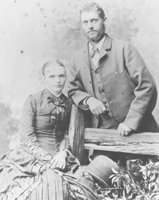 Ringwood and District Historical Society
Archive - Biographical material, Maggs Family of Ringwood and District (Parent Record)
Transcript of the Maggs Family History, given by Joan Walker, former member of RDHS:- Pioneer Family - Maggs • James Maggs and wife Harriet Banfield migrated to Melbourne on the “Ticondergoa” which sailed from Birkenhead on 4th August 1852 with 812 assisted immigrants. • In 1856 James purchased 7 acres of land, part of section 75, in the parish of Nunawading where he developed an orchard. • Three children died young – Emma (before 1862), Jemima at Ticonderoga Bay and Mary Jane aged 3 weeks at Koonung Creek. Three sons and a daughter survived them. Harriet died in 1875, James in 1888 both buried in Box Hill cemetery. • Their sons Joseph, Samuel and James all established orchards in the Ringwood/Croydon district. Samuel Maggs • Born 11 May 1851, Somerset, England and grew up on his fathers property in Springfield Road, Blackburn, one block east of Surrey Road. • On 4 October 1876 Sam married Eliza Ann Barnes. • 1881 purchased a block, Allot. 39 Parish of Warrandyte and developed an apple and cherry orchard. The orchard occupied the area between White Horse Road and Mullum Mullum Creek from Oban Rd east to where White Horse Road takes a slight turn to the right, near Burnt Bridge. • Son George b.28 December 1876 Warrandyte married Annie Smith d.9 May 1947. • Daughter Eliza Jane b.27 July 1878 Ringwood married William Dobbin, d.31 May 1946 Camberwell. • Son James b.15 May 1880, Lilydale married Catherine Atkins d.28 July 1940 Ringwood buried Box Hill. • Daughter Jemima b.16 December 1881 Warrandyte married Edward Lindsay in 1905, d.2 November 1955 and buried in Box Hill. • Daughter Jane b.22 May 1884 Warrandyte married Thomas S Knee in 1912 d.31 January 1971, buried at Box Hill. • Son Samuel William b.1 Jan 1889 Ringwood married Mina Lillian Schuhkraft in 1911 d.15 Jan 1955 Ringwood. Joseph Maggs • Born 5 June 1845, Somerset England. • Married Mary Ann Reid in April 1867 at Templestowe. • Bought Sec. 26a, in Ringwood on the corner of Eastfield Road an Mt Dandenong Road in February 1870. Planted 4 acres with fruit trees. Was also a wood carter. During the 1880s white clay was mined here, which he carted for the Victorian Porcelain Clay Coy. • Daughter Emma b.8 Jan 1868 Templestowe d. 3 August 1939, Richmond married May 1890 Fredrick W. McGinnis. • Daughter Agnes b.16 June 1869 Templestowe married John D Miller c.1894. d.3 February 1912 Heathmont, buried Box Hill. • Son Albert b.1 May 1871 Nunawading d.15 Nov 1893. • Son Hubert b.10 May 1873 Nunawading married Isabella Atkins in 1898 Ringwood d.11 August Wagga Wagga and buried there. • Daughter Harriet Annis b.13 August 1875 Box Hill d.21 Sept 1875. • Son Joseph b.25 September 1876 Box Hill d.3 Oct 1900 Mitcham. • Daughter Harriet Annis b.18 Aug 1879, Ringwood married James R Miller d.8 May 1945. • Son William b.3 Sep 1881 married Mary E Hardidge. D.6 April 1950 South Melbourne. • Daughter Dora Jane Dulcie b.13 December 1883 Ringwood d.1973. • Daughter Delia Rose b.20 February 1886, Ringwood married William J Sharkie d.30 October 1914 James Maggs • Youngest (born 28 April 1862, Blackburn) and only Australian born son was also an orchardist. • Married Marianne Hardidge in 1880 (divorced in 1906) purchased land in what is now Kalinda Road, adjoining Sam’s land. • James lived with Teresa Shanks in the Hawthorn and Prahran districts and became a taxi driver. Died in 1925, buried at Box Hill. Marianne became a midwife who delivered over 500 babies in the area – was known as Nurse Polly Maggs, died in 1941 aged 81. • Daughter Mary Ann Hase Polly b.5 July 1881 Ringwood married Thomas Lawford d.9 November 1961 buried at Box Hill. • Daughter Jane Emma b.9 May 1883 Ringwood married Frederick Bloom 1910 d.28 July 1954. • Daughter James John b.17 Jan 1885 Ringwood married Johanna Ida Edith Bloom in 1912 d.24 August 1962 buried at Box Hill. • Daughter David Joseph b.31 Jan 1887 Ringwood married Violet Lepp married 1916, d.11 July 1966. • Son Samuel Arthur b.11 March 1888 Ringwood married Bertha Anna Pump in 1913 d.7 August 1957. • Son John William b.16 April 1890 Ringwood married Lillian Mabel May Smith in 1909 d.18 February 1959 Cobram. • Daughter Eliza Anne b.6 March 1892 Ringwood d.April 18 1892. • Son Robert Thomas b.7 March 1893 Ringwood married Edith E Britnell in 1919 d.12 March 1981 buried Box Hill. • Son Albert Edward b.12 April 1895 Ringwood married Florence Sarah Pearce in 1918 d.30 January 1976 buried at Springvale. • Daughter Evaleen Victoria b.28 Aug 1897, Ringwood married Sydney Till married 1920 d.5 September 1989 buried at Box Hill. • Daughter Harriet Banfield Chrissy b.14 December 1899 Ringwood d.28 Dec 1979 buried Box Hill. Jane Maggs • Born 19 December 1858 in Blackburn. Died 5 July 1926 buried at Box Hill. Married William Cook and had one child, Harriet Amy Cook who never married and lived in Whitehorse Road, Mitcham until her death in 1962. Details, extract from Family Tree Maker family tree:- Descendants of James Maggs Generation No. 1 1. JAMES5 MAGGS (JOSEPH4, WILLIAM3, WILLIAM2, SAMUEL1)1 died 24 Sep 18881. He married (1) HARRIET MARTHA BANFIELD1 23 Dec 1841 in Bristol, Somerset, England1. She was born 19 Jun 1817 in Clutton, Somerset, England1, and died 12 May 1875 in Nunawading, Victoria, Australia1. He married (2) ROSENA MAHON1 09 Dec 1875 in Fitzroy, Victoria, Australia1. She was born in Deptford, London, England1. Notes for JAMES MAGGS: JAMES MAGGS, and his wife HARRIET BANFIELD, migrated to Melbourne on the "Ticonderoga", which sailed from Birkenhead 4th Aug 1852 with 812 assisted immigrants aboard. In the close confines of the ship fever broke out and by the time she arrived off Port Phillip Heads on or about 2nd Nov, 100 deaths had been recorded in the log and hundreds were too weak to help themselves. Captain Wylie of the coastal trader "Champion", informed Captain Ferguson, the harbourmaster at Williamstown, of the tragic plight of the passengers and crew, and he came with two doctors, in the "Empire", to their aid. They anchored just inside Port Phillip Heads on 5 Nov. at the "Sanatory Station", declared but not yet established by the local authorities. Those who were well enough were put ashore in tents made of spars and sails. The "Lysander" was despatched from Melbourne to act as a hospital ship, and 2 houses, built of the local limestone, were commandeered as a quarantine station. For six weeks the survivors were held near Point Nepean at a place still known as Ticonderoga Bay while the fever, propably typhus, a louse borne epidemic disease, ran its course and a further 68 passengers, 2 crew members and 4 newborn babes succumbed to the scourge. Among them was Jemima Maggs, 3 year old daughter of James and Harriet. The dead were buried at the waters edge, in a grove of titree, a site now marked by Heaton's monument. The remainder of the family, including Samuel, just one year old, lived through the ordeal to make a new life in Australia. James obtained work with Robert Wilson of Bulleen for a period of 3 months at a wage of 52 pounds per annum with rations. By 1856 he was able to purchase 7 acres of land, part of section 75, in the parish of Nunawading at 5 pounds per acre. Here he developed an orchard by means of various mortgages including one taken out 17 July 1872 for 50 pounds from the Victorian Permanent Property Investment & Building Society. Three of their seven children died young, Emma before 1862, Jemima at Ticonderoga Bay, and Mary Jane, the first of their three Australian born children, aged 3 weeks at Konung Creek.Three sons and a daughter survived them. Harriet died in 1875, James lived until 1888 and both are buried at the Box Hill Cemetery. Their sons, Joseph, Samuel, and James all established orchards in the Ringwood/Croydon district. Bur Reg 308 Box Hill Grave #64 Presbyterian More About JAMES MAGGS: Ancestral File Number: LN0V-G01 Burial: 26 Sep 1888, Box Hill, Victoria, Australia1 Christening: 20 Oct 1816, Clutton, Somerset, England1 Record Change: 03 Oct 20041 More About HARRIET MARTHA BANFIELD: Ancestral File Number: LN0V-N11 Burial: 14 May 1875, Box Hill, Victoria, Australia1 Christening: 31 Aug 18171 Record Change: 29 Nov 20041 More About ROSENA MAHON: Record Change: 01 Dec 20011 Children of JAMES MAGGS and HARRIET BANFIELD are: i. EMMA6 MAGGS1, b. 13 Nov 1843, Clutton, Somerset, England1. More About EMMA MAGGS: Record Change: 08 Jul 20031 2. ii. JOSEPH MAGGS, b. 05 Jun 1845, Clutton, Somerset, England; d. 24 Jun 1886, Ringwood, Victoria, Australia. iii. JEMIMA MAGGS1, b. 25 Oct 1848, Clutton, Somerset, England1; d. 1852, Ticonderoga Bay, Victoria, Australia1. More About JEMIMA MAGGS: Record Change: 24 Jan 20031 3. iv. SAMUEL MAGGS, b. 11 May 1851, Clutton, Somerset, England; d. 30 Aug 1942, Croydon, Victoria, Australia. v. MARY JANY MAGGS1, b. 03 Dec 1855, Konung Creek, Victoria, Australia1; d. 27 Dec 18551. More About MARY JANY MAGGS: Record Change: 23 Jan 20051 4. vi. JANE MAGGS, b. 19 Dec 1858, Blackburn, Victoria, Australia; d. 05 Jul 1926, , Victoria, Australia. 5. vii. JAMES MAGGS, b. 1862, Nunawading; d. 1925, Fitzroy. Generation No. 2 2. JOSEPH6 MAGGS (JAMES5, JOSEPH4, WILLIAM3, WILLIAM2, SAMUEL1)1 was born 05 Jun 1845 in Clutton, Somerset, England1, and died 24 Jun 1886 in Ringwood, Victoria, Australia1. He married MARY ANN READ1 01 Apr 1867 in Templestowe, Victoria, Australia1. She was born Abt. 1847 in of Templestowe, Victoria, Australia1, and died 1925 in Ringwood, Victoria, Australia1. Notes for JOSEPH MAGGS: Joseph Maggs born 5 Jun 1845 at Clutton, Somerset, England, arrived in Australia age 7 years. He married Mary Ann Read, in Apr 1867 at Templestowe, selected land, Lot 26a,in Ringwood on the corner of Eastfield Road and Mt.Dandenong Road, approx 114 acres, at 11 o'clock 2 Feb 1870. He planted 4 acres with fruit trees valued at 80 pounds and by Sep 1874 his occupation was farmer and wood carter. A 4 room house of lathe and plaster with a paling roof, a kitchen, a slab and bark stable and a pigsty had been errected to a value of 71 pounds. A well, 3 dams, clearing and fencing valued at 96 pounds are also listed. He notes "from the nature of the land, being very poor and heavily timbered, I have not been quite able to clear the complement required, not having means sufficient to do so, neither will the land pay when cultivated." Traces of antimony were found on the land but not in commercial quantities, however during the 1880s white clay was mined here, which he carted for the Victoria Porcelain Clay Coy. In Mar 1880 he was granted freehold title at a price of one pound per acre. More About JOSEPH MAGGS: Burial: Box Hill, Victoria, Australia1 Record Change: 18 Feb 20011 More About MARY ANN READ: Burial: Box Hill, Victoria, Australia1 Record Change: 21 Jul 20021 Children of JOSEPH MAGGS and MARY READ are: 6. i. EMMA7 MAGGS, b. 08 Jan 1868, Templestowe, Victoria, Australia; d. 03 Aug 1939, Richmond, Victoria, Australia. ii. ALBERT MAGGS1, b. 01 May 1871, Nunawading, Victoria, Australia1; d. 15 Nov 1893, Ringwood, Victoria, Australia1. More About ALBERT MAGGS: Record Change: 12 Oct 19971 7. iii. HUBERT MAGGS, b. 10 May 1873, Ringwood, Victoria, Australia; d. 11 Aug 1956, Wagga Wagga, N.S.W., Australia. iv. HARRIET ANNIS MAGGS1, b. 13 Aug 1875, Box Hill, Victoria, Australia1; d. Ringwood, Victoria, Australia1. More About HARRIET ANNIS MAGGS: Burial: 21 Sep 1875, Box Hill, Victoria, Australia1 Record Change: 18 Feb 20011 v. JOSEPH MAGGS1, b. 25 Sep 1876, Box Hill, Victoria, Australia1; d. 03 Oct 1900, Mitcham, Victoria, Australia1. More About JOSEPH MAGGS: Record Change: 18 Feb 20011 8. vi. HARRIET ANNIS MAGGS, b. 18 Aug 1879, Ringwood, Victoria, Australia; d. 08 May 1945. vii. WILLIAM MAGGS1, b. 03 Sep 18811; d. 06 Apr 1950, South Melbourne, Victoria, Australia1; m. MARY ELIZA HARDIDGE1, 24 Dec 1912, Goulburn, N.S.W., Australia1; b. Abt. 1884, , of Victoria, Australia1; d. 1956, Lilydale, Victoria, Australia1. More About WILLIAM MAGGS: Record Change: 18 Feb 20011 More About MARY ELIZA HARDIDGE: Record Change: 18 Feb 20011 viii. DORA JANE DULCIE MAGGS1, b. 13 Dec 1883, Ringwood, Victoria, Australia1; d. 1973, Mitcham, Victoria, Australia1. More About DORA JANE DULCIE MAGGS: Record Change: 21 Jan 20021 9. ix. DELIA ROSE MAGGS, b. 20 Feb 1886, Ringwood, Victoria, Australia; d. 30 Oct 1914. 10. x. AGNES MAGGS, b. 16 Jun 1869, Templestowe, Victoria, Australia; d. 03 Feb 1912, Heathmont, Victoria, Australia. 3. SAMUEL6 MAGGS (JAMES5, JOSEPH4, WILLIAM3, WILLIAM2, SAMUEL1)1 was born 11 May 1851 in Clutton, Somerset, England1, and died 30 Aug 1942 in Croydon, Victoria, Australia1. He married ELIZA ANN BARNES1 04 Oct 1876 in Nunawading, Victoria, Australia1. She was born 19 Sep 1848 in St Lukes, London, England1, and died 17 Feb 1923 in Croydon, Victoria, Australia1. Notes for SAMUEL MAGGS: SAMUEL MAGGS grew up on his father's property in Springfield Road, Blackburn, one block east of Surrey Road. West of Surrey Road and fronting to White Horse Road was James Barnes' property, so by walking through the Maggs land and crossing Surrey Road, one might enter the back of the Barnes land, an easy way to visit ELIZA ANN BARNES. On the 4 Oct 1876 Sam and Eliza were married at her father's house. Sam wrote to the Secretary for Lands on the 29 Sep 1880, requesting that Allot. 39 Parish of Warrandyte be made available for selection. This block had been refused for selection earlier on the objection of the Mines Department as it was believed that the area was auriferous. When told that the block was available, Sam marked it at 5 o'clock December 3rd and applied for a lease of 12 acres 3 rods and 34 perches on the 6th December. On the application it is noted that he already had leasehold of 104 acres. His license was approved 7 Mar 1881 at a rate of 6 shillings and 6 pence per halfyear. Previously paid fees and rental came to 3 pounds 18 shillings, and he paid another pound for a certificate fee, a pound lease fee, plus the first half years rental, then proceeded to develop the land into an apple and cherry orchard.In 7 Mar 1898 he had succeeded in securing the freehold grant of the area by paying 2 pounds 18 shillings 6 pence fees due,plus a 1 guinea grant fee and assurance fund contribution of 7 pence, a total of 4 pounds and 1 penny. The orchard occupied the area between White Horse Rd and Mullum Mullum Creek,from Oban Rd east to where White Horse Road, now the Maroondah Highway, takes a slight turn to the right, near the Burnt Bridge. Sam and Eliza built a house on Sec38 and planted Fivecrown apples grafted on a Maggs Seedling stock at 24 ft spacing. Trees put in about 1875 were yielding up to twenty bushells 30 years later. He didn't approve of regulations which required spraying for codlin moth and was reputed to have said when denied coolstorage space until he sprayed his trees, "No one is going to tell me how to grow apples and anyway a bit of codlin is good for you". More About SAMUEL MAGGS: Ancestral File Number: LN0V-8X1 Record Change: 20 Aug 19971 Notes for ELIZA ANN BARNES: ELIZA ANN BARNES married SAMUEL MAGGS, son of neighbouring land owner, James Maggs, 4 Oct 1876 and had 6 children. She had a stroke about 1921 but was able to attend her seventyfourth birthday party held at her daughter Jane Knee's home in Sep 1922 when over forty family members gathered for the celebration(see photo). She died 17 Feb 1923 at Croydon. More About ELIZA ANN BARNES: Ancestral File Number: LN0V-2W1 Record Change: 20 Aug 19971 Children of SAMUEL MAGGS and ELIZA BARNES are: 11. i. GEORGE7 MAGGS, b. 28 Dec 1876, Warrandyte, Victoria, Australia; d. 09 May 1947, Ringwood, Victoria, Australia. 12. ii. ELIZA JANE MAGGS, b. 27 Jul 1878, Ringwood, Victoria, Australia; d. 31 May 1946, Camberwell, Victoria, Australia. 13. iii. JAMES MAGGS, b. 15 May 1880, Lilydale, Victoria, Australia; d. 28 Jul 1940, Ringwood, Victoria, Australia. iv. JANE MAGGS1, b. 22 May 1884, Warrandyte, Victoria, Australia1; d. 31 Jan 19711; m. THOMAS SAMUEL KNEE1, 1907, , Victoria, Australia1; b. 07 Aug 1881, Lilydale, Victoria, Australia1; d. 19 Apr 19601. More About JANE MAGGS: Burial: Box Hill, Victoria, Australia1 Record Change: 18 Feb 20011 More About THOMAS SAMUEL KNEE: Burial: 21 Apr 1960, Box Hill, Victoria, Australia1 Record Change: 22 Aug 20031 14. v. SAMUEL WILLIAM MAGGS, b. 01 Jan 1889, Ringwood, Victoria, Australia; d. 15 Jan 1955, Ringwood, Victoria, Australia. 15. vi. JEMIMA MAGGS, b. 16 Dec 1881, Warrandyte, Victoria, Australia; d. 02 Nov 1955. 4. JANE6 MAGGS (JAMES5, JOSEPH4, WILLIAM3, WILLIAM2, SAMUEL1)1 was born 19 Dec 1858 in Blackburn, Victoria, Australia1, and died 05 Jul 1926 in , Victoria, Australia1. She married WILLIAM COOK1 1880 in , Victoria, Australia1. He was born Abt. 1859 in Wickliffe, Victoria, Australia1, and died 09 Aug 19391. Notes for JANE MAGGS: Jane Maggs, the only surviving daughter of James and Harriet, married William Cook and had one child, Harriet Amy Cook, known to her relatives as Cousin Amy. She never married and lived in the house inWhitehorse Road, Mitcham built by her parents, for many years until her death in 1962. She took a keen interest in family history and was a great source of information and memorabilia about the early days of the Ringwood area. More About JANE MAGGS: Burial: Box Hill1 Record Change: 18 Feb 20011 More About WILLIAM COOK: Burial: 10 Aug 1939, Box Hill, Victoria, Australia1 Record Change: 05 Nov 20011 Child of JANE MAGGS and WILLIAM COOK is: i. HARRIET AMEY7 COOK1, b. 1881, Box Hill, Victoria, Australia1; d. 13 Sep 1962, Surrey Hills, Victoria, Australia1. More About HARRIET AMEY COOK: Burial: 17 Sep 1962, Box Hill, Victoria, Australia1 Record Change: 18 Feb 20011 5. JAMES6 MAGGS (JAMES5, JOSEPH4, WILLIAM3, WILLIAM2, SAMUEL1)2,3 was born 1862 in Nunawading4, and died 1925 in Fitzroy4. He married (1) THERESA BROWN4 in Christchurch, New Zealand5. She was born 1869 in Clunes, Victoria, Australia5, and died 1930 in Prahran, Victoria, Australia5. He married (2) MARIANNE HARDIDGE6 1880 in Kew6. She was born 1860 in Doncaster6, and died 1941 in Mitcham6. He married (3) ADA JANE CROY7 19127. She was born 1883 in ,Victoria, Australia7. Notes for JAMES MAGGS: James Maggs, the youngest child and only Australian born son of James and Harriet, was an orchardist like his older brothers. He married Marianne Hardidge in 1880 and selected an area in what is now Kalinda Road, adjoining Sam's land. They constructed a four roomed house measuring 26 feet square valued at fifty pounds and stables valued at forty pounds. The buildings were made of palings with an iron roof. Here they raised ten children and lost a little girl, Eliza, aged three weeks. In 1900 James became seriously ill with a kidney disease and was visited during his illness by a wide section of his neighbours, including Mrs Theresa Shanks. He and Theresa became attracted to each other and broke up their marriages, with James and Marianne being divorced in 1906. James and Theresa lived in the Hawthorn and Prahran districts and he became a taxi driver. He contributed to the upkeep of his children although the divorce was a bitter affair. He died in 1925 in Fitzroy and Theresa only survived him by five years. They are buried in the same grave at Box Hill. Marianne became a midwife who delivered over 500 babies in the neighborhood. She was known as Nurse Polly Maggs and the people of Ringwood presented her with a wireless set in appreciation of her service to the community. She died at the age of 81 years in 1941. More About JAMES MAGGS: Burial: Box Hill Cemetery8 Record Change: 01 Sep 20018 Notes for THERESA BROWN: [Ringwood.ged] Theresa had a son Jim Shanks born1902 (father was James Maggs) Reg No 12243R More About THERESA BROWN: Burial: 05 Feb 1930, Box Hill, Victoria, Australia9 Record Change: 01 Sep 200110 More About MARIANNE HARDIDGE: Burial: Box Hill Cemetery10 Record Change: 01 Sep 200110 Marriage Notes for JAMES MAGGS and MARIANNE HARDIDGE: [Ringwood.ged] divorced in 1906 More About ADA JANE CROY: Burial: 15 Apr 1932, Geelong, Victoria, Australia11 Record Change: 10 Aug 200211 Child of JAMES MAGGS and THERESA BROWN is: i. JIM7 MAGGS12, b. 190212. More About JIM MAGGS: Record Change: 01 Sep 200112 Children of JAMES MAGGS and MARIANNE HARDIDGE are: ii. MARY ANN HASE7 MAGGS12, b. 188112. More About MARY ANN HASE MAGGS: Record Change: 01 Sep 200112 16. iii. JANE EMMA MAGGS, b. 1883; d. 28 Jul 1954. 17. iv. JAMES JOHN MAGGS, b. 1885; d. 24 Aug 1962, Parkville, Victoria, Australia. v. DAVID JOSEPH MAGGS12,13, b. 188714; d. 11 Jul 1966, Mt. Waverley, Victoria, Australia15; m. VIOLET ADELINE LEPP15, 1916, , Victoria, Australia15; b. 1888, Ballarat, Victoria, Australia15; d. 26 Mar 1966, ,Victoria, Australia15. More About DAVID JOSEPH MAGGS: Record Change: 01 Sep 200116 More About VIOLET ADELINE LEPP: Record Change: 21 Jan 200217 18. vi. SAMUEL ARTHUR MAGGS, b. 1888; d. 07 Aug 1957, Doncaster, Victoria, Australia. 19. vii. JOHN WILLIAM MAGGS, b. 1890; d. 18 Feb 1959, Cobram, Victoria, Australia. viii. ELIZA ANN MAGGS18, b. 189218; d. 189218. More About ELIZA ANN MAGGS: Burial: Box Hill Cemetery18 Record Change: 01 Sep 200118 20. ix. ROBERT THOMAS MAGGS, b. 1893; d. 12 Mar 1981. 21. x. ALBERT EDWARD MAGGS, b. 1895; d. 1976. 22. xi. EVALEEN VICTORIA MAGGS, b. 1897; d. 05 Sep 1989. xii. HARRIET BANFIELD MAGGS18, b. 189918. More About HARRIET BANFIELD MAGGS: Record Change: 01 Sep 200118 23. xiii. MARY ANN HASE POLLY MAGGS, b. 05 Jul 1881, Ringwood, Victoria, Australia; d. 09 Nov 1961. xiv. HARRIET BANFIELD CHRISSY MAGGS19, b. 14 Dec 1899, Ringwood, Victoria, Australia19; d. 28 Dec 1979, Blackburn, Victoria, Australia19. More About HARRIET BANFIELD CHRISSY MAGGS: Burial: Box Hill19 Record Change: 18 Feb 200119 Children of JAMES MAGGS and ADA CROY are: xv. CLENCIE JOAN7 MAGGS19, m. ARTHUR RODERICK PITTER19. xvi. CLYDE MAGGS19, b. 1917, Collingwood, Victoria, Australia19; d. 1917, Collingwood, Victoria, Australia19. More About CLYDE MAGGS: Record Change: 10 Aug 200219 Generation No. 3 6. EMMA7 MAGGS (JOSEPH6, JAMES5, JOSEPH4, WILLIAM3, WILLIAM2, SAMUEL1)19 was born 08 Jan 1868 in Templestowe, Victoria, Australia19, and died 03 Aug 1939 in Richmond, Victoria, Australia19. She married FREDRICK WILLIAM MCGINNIS19 May 1890 in , Victoria, Australia19. He was born in , of Victoria, Australia19. More About EMMA MAGGS: Record Change: 18 Feb 200119 More About FREDRICK WILLIAM MCGINNIS: Record Change: 18 Feb 200119 Children of EMMA MAGGS and FREDRICK MCGINNIS are: i. RENIRA EDDA8 MCGINNIS19. ii. FREDRICK HENRY MCGINNIS19, b. 1894, , of Victoria, Australia19; d. 195819. More About FREDRICK HENRY MCGINNIS: Record Change: 18 Feb 200119 7. HUBERT7 MAGGS (JOSEPH6, JAMES5, JOSEPH4, WILLIAM3, WILLIAM2, SAMUEL1)19 was born 10 May 1873 in Ringwood, Victoria, Australia19, and died 11 Aug 1956 in Wagga Wagga, N.S.W., Australia19. He married ISABELLA ATKINS19 09 Mar 1898 in Ringwood, Victoria, Australia19. She was born Abt. 1875 in St Arnaud, Victoria, Australia19. More About HUBERT MAGGS: Burial: Wagga Wagga, N.S.W., Australia19 Record Change: 23 Jan 200519 More About ISABELLA ATKINS: Record Change: 23 Jan 200519 Children of HUBERT MAGGS and ISABELLA ATKINS are: i. HUBERT CARLYLE8 MAGGS19. ii. ANNE THORA MAGGS19. iii. RAYMOND MAGGS19, b. 09 Jun 1905, Ringwood, Victoria, Australia19; d. 20 Jul 190519. More About RAYMOND MAGGS: Record Change: 18 Feb 200119 8. HARRIET ANNIS7 MAGGS (JOSEPH6, JAMES5, JOSEPH4, WILLIAM3, WILLIAM2, SAMUEL1)19 was born 18 Aug 1879 in Ringwood, Victoria, Australia19, and died 08 May 194519. She married JAMES RICHARD MILLER19 26 Sep 1910 in Ringwood East, Victoria, Australia19. He was born 1878 in Collingwood, Victoria, Australia19. More About HARRIET ANNIS MAGGS: Record Change: 18 Feb 200119 More About JAMES RICHARD MILLER: Record Change: 18 Feb 200119 Children of HARRIET MAGGS and JAMES MILLER are: i. DUDLEY8 MILLER19. ii. IRENE DOROTHY MILLER19, b. 10 Nov 1913, , of Victoria, Australia19; d. 29 Sep 199019. More About IRENE DOROTHY MILLER: Burial: Lilydale, Victoria, Australia19 Record Change: 18 Feb 200119 iii. CYRIL MILLER19, b. 26 Sep 1915, , of Victoria, Australia19; d. 05 Apr 197319. More About CYRIL MILLER: Burial: Springvale, Victoria, Australia19 Record Change: 18 Feb 200119 9. DELIA ROSE7 MAGGS (JOSEPH6, JAMES5, JOSEPH4, WILLIAM3, WILLIAM2, SAMUEL1)19 was born 20 Feb 1886 in Ringwood, Victoria, Australia19, and died 30 Oct 191419. She married WILLIAM JAMES SHARKIE19. More About DELIA ROSE MAGGS: Burial: Box Hill, Victoria, Australia19 Record Change: 18 Feb 200119 Child of DELIA MAGGS and WILLIAM SHARKIE is: i. RONALD8 SHARKIE19, b. Abt. 1914, , of Victoria, Australia19; d. Abt. 1964, , N.S.W., Australia19. More About RONALD SHARKIE: Record Change: 15 Oct 200119 10. AGNES7 MAGGS (JOSEPH6, JAMES5, JOSEPH4, WILLIAM3, WILLIAM2, SAMUEL1)20,21 was born 16 Jun 1869 in Templestowe, Victoria, Australia21, and died 03 Feb 1912 in Heathmont, Victoria, Australia21. She married (1) JOHN DOMONIC MILLER22 189423,24, son of FRANK MILLER and KATE MADDEN. He was born 187025,26, and died 194227,28. She married (2) JOHN DOMINIC MILLER29 1894 in , Victoria, Australia30,31. He was born 1870 in Box Hill, Victoria, Australia31. More About AGNES MAGGS: Burial: Box Hill, Victoria, Australia31 Record Change: 11 Sep 200132 More About JOHN DOMONIC MILLER: Record Change: 11 Sep 200132 More About JOHN DOMINIC MILLER: Record Change: 18 Feb 200133 Children of AGNES MAGGS and JOHN MILLER are: i. ALBERT JOHN8 MILLER33, b. 1894, , of Victoria, Australia33. More About ALBERT JOHN MILLER: Record Change: 18 Feb 200133 ii. LOUIS NICHOLAS MILLER33, b. 1901, , of Victoria, Australia33; d. 197433; m. LILA MERTON33. More About LOUIS NICHOLAS MILLER: Record Change: 18 Feb 200133 iii. LESLIE DOMINIC MILLER33, b. 1904, , of Victoria, Australia33; d. 198933. More About LESLIE DOMINIC MILLER: Record Change: 18 Feb 200133 11. GEORGE7 MAGGS (SAMUEL6, JAMES5, JOSEPH4, WILLIAM3, WILLIAM2, SAMUEL1)33 was born 28 Dec 1876 in Warrandyte, Victoria, Australia33, and died 09 May 1947 in Ringwood, Victoria, Australia33. He married ANNIE GRACE SMITH33 26 Mar 1902 in , Victoria, Australia33. She was born Abt. 1878 in of Ringwood, Victoria, Australia33, and died 1967 in Box Hill, Victoria, Australia33. More About GEORGE MAGGS: Record Change: 18 Feb 200133 More About ANNIE GRACE SMITH: Record Change: 21 Jan 200233 Children of GEORGE MAGGS and ANNIE SMITH are: i. CLYDE8 MAGGS33, m. VIOLET OXENBURY33. 24. ii. GEORGE ALBERT MAGGS, b. 17 Jul 1902, Ringwood, Victoria, Australia; d. 1974, Heidelberg, Victoria, Australia. iii. HILDA GLADYS BILLIE MAGGS33, b. 05 Sep 1903, Ringwood, Victoria, Australia33; d. 15 Oct 198733; m. LENARD DRYSDALE REID33. More About HILDA GLADYS BILLIE MAGGS: Burial: Springvale, Victoria, Australia33 Record Change: 18 Feb 200133 iv. MYRTLE OLIVE MAGGS33, b. 24 Dec 1905, Kew, Victoria, Australia33; d. 02 Jan 198333; m. ROBERT SAMUEL BOB HEAD33, 1924, , Victoria, Australia33; b. 1898, , of Victoria, Australia33; d. 15 Oct 1980, Mermaid Beach, Queensland, Australia33. More About MYRTLE OLIVE MAGGS: Record Change: 18 Feb 200133 More About ROBERT SAMUEL BOB HEAD: Burial: 17 Oct 1980, Nerang, Queensland, Australia33 Record Change: 18 Feb 200133 v. FREDERICK STANLEY MAGGS33, b. 10 Jul 1907, of, Victoria, Australia33; d. 26 Jan 1975, Box Hill, Victoria, Australia33; m. (1) RUBY EMILY BRIERLEY33; m. (2) SARAH MRS FREDERICK MAGGS33; m. (3) ISABEL WOOD33. More About FREDERICK STANLEY MAGGS: Record Change: 21 Jul 200233 vi. ALFRED FRANCIS MAGGS33, b. 19 Jun 1909, Ringwood, Victoria, Australia33; d. 06 Feb 198733; m. FRANCES ESTELLE WILLOUGHBY33. More About ALFRED FRANCIS MAGGS: Record Change: 18 Feb 200133 vii. ERIC RAYMOND MAGGS33, b. 29 Nov 1910, Ringwood, Victoria, Australia33; d. 29 Jan 198633; m. THELMA THOMPSON33. More About ERIC RAYMOND MAGGS: Record Change: 18 Feb 200133 viii. MARJORIE FLORENCE MAGGS33, b. 21 Jun 1912, Ringwood, Victoria, Australia33; d. 20 Aug 197433; m. COLIN ADDISON33. More About MARJORIE FLORENCE MAGGS: Record Change: 18 Feb 200133 ix. CLARICE MAGGS33, b. 20 Dec 1913, , Victoria, Australia33; m. RONALD STONE33. More About CLARICE MAGGS: Burial: , Queensland, Australia33 Record Change: 18 Feb 200133 12. ELIZA JANE7 MAGGS (SAMUEL6, JAMES5, JOSEPH4, WILLIAM3, WILLIAM2, SAMUEL1)33 was born 27 Jul 1878 in Ringwood, Victoria, Australia33, and died 31 May 1946 in Camberwell, Victoria, Australia33. She married WILLIAM NEWCOMB DOBBIN33 14 Mar 1900 in Ringwood, Victoria, Australia34,35. He was born 02 Aug 1878 in Bendigo, Victoria, Australia35, and died 12 May 1960 in Brighton, Victoria, Australia35. More About ELIZA JANE MAGGS: Ancestral File Number: LN0T-NV35 Record Change: 20 Aug 199735 Notes for WILLIAM NEWCOMB DOBBIN: WILLIAM NEWCOMB DOBBIN, the second child of William Edward Jones Dobbin and Amelia Matilda Shoman, was born at Bendigo in the state of Victoria, on the 2 August 1878. He spent his early childhood years in the goldfields towns of Bendigo and Ballarat but by the time he was of age to start school his family had moved to Melbourne and he commenced his education at the Richmond State school. His first job as a baker's boy in Ringwood included delivering bread by bicycle to homes in that area, and that was how he met ELIZA JANE MAGGS. By the time he turned 17 he had decided to go to Western Australia so in 1895 he embarked on a ship named the "Inaminka" which carried a deck cargo of draught horses. While crossing the Great Australian Bight a severe storm was encountered and three of the fifteen horses on deck were killed. He found work in a timber camp in the south west,near Albany, and lived in a hut made of palings for a time with five other men. While he was there an itinerant Indian photographer named S.Bhan took a picture of the hut with its inhabitants standing outside. Approaching the turn of the century his mind turned to thoughts of marriage. He returned to Victoria and proposed to Eliza Jane. They were married on the 14 March 1900 at Lilydale Road Ringwood according to the rites of the Church of Christ by Thomas Hagger in the presence of George Maggs,the brother of the bride and Elizabeth Frances Bell. He and his bride returned to Western Australia on a ship called the "Oruba" and when their first child was born at Denmark, on the 18 January 1901 he named her VERA ORUBA DOBBIN. Eliza Jane found the living conditions very rough and because of poor health she returned to Victoria when Vera was three months old. William followed on a ship called the "Suvic". Their second child, Cyril William Dobbin was born at Ringwood in October 1902 where William worked an orchard owned by his father-in-law, Sam Maggs. He purchased from Sam an area in Wonga Park Rd, (now Kalinda Rd) north of the creek which had been planted as a cherry orchard and part of the area on the corner of Oban Road He also worked in a pottery and in the 1905 Sands and McDougall directory he is listed as a brick and tile maker. In 1917 he rented premises in Main Street (Whitehorse Road), Ringwood, then newly built by J.B.McAlpin, the estate agent, on the corner of Melbourne Street. The shop between A.C.Beilby's store and McAlpin's office on the corner was opened as "The Railway Fruit and Confectionary Palace" and a shop in Melbourne Street, which adjoined the Main Street shop at the rear, became "The Fernery Refreshment Rooms". Three more children were born at Ringwood, Leonard Suvic in 1905, Clarence Newcomb in 1907, and the youngest child, a daughter named Elvie Olive in 1909. A fruit shop in Melrose Street, Sandringham, "The Covent Garden Fruit Palace" was purchased in 1921 and later taken over by his son Cyril. During the early 1930's his marriage failed and he went to Williamstown and opened a florist shop in the name of Walter Dobson which did very well. He married again and settled down to a life of retirement in Prahran, but his second wife, Elsie Fritzlaff (formerly Mrs Wilson) died unexpectedly and he was left alone once more. His eyesight deteriorated badly in his later years and he eventually entered the Mair Street Home for the Blind in Brighton where he died on the 12 May 1960. More About WILLIAM NEWCOMB DOBBIN: Ancestral File Number: LN0S-PW35 Record Change: 31 Mar 200135 Children of ELIZA MAGGS and WILLIAM DOBBIN are: i. ELVIE OLIVE8 DOBBIN35, m. ROY STEWART35; b. 1904, Landsborough, Victoria, Australia35; d. 30 Jun 1992, , Victoria, Australia35. More About ROY STEWART: Record Change: 18 Feb 200135 ii. VERA ORUBA DOBBIN35, b. 18 Jan 1901, Denmark, W.A., Australia35; d. 16 May 1995, Warwick, W.A., Australia35; m. ALEXANDER FRANCIS LAIRD35, 16 May 1923, Hampton, Victoria, Australia35; b. 24 Sep 1898, Collingwood, Victoria, Australia35; d. 21 Jul 1981, Kallaroo, W.A., Australia35. More About VERA ORUBA DOBBIN: Record Change: 02 Sep 200435 More About ALEXANDER FRANCIS LAIRD: Ancestral File Number: LN0Q-QS35 Record Change: 02 Sep 200435 iii. CYRIL WILLIAM DOBBIN35, b. 22 Oct 1902, Ringwood, Victoria, Australia35; d. 10 Aug 1989, Frankston, Victoria, Australia35; m. FLORENCE CONSTANCE DAVIDSON35, 22 Mar 1925, Brighton, Victoria, Australia35; b. 08 Mar 1903, South Melbourne, Victoria, Australia35; d. Jun 1987, Australia35. More About CYRIL WILLIAM DOBBIN: Record Change: 18 Feb 200135 Notes for FLORENCE CONSTANCE DAVIDSON: Notes: written by Carol Humphrey (daughter) 2001 Florence Constance Davidson, born in South Melbourne, was the second eldest child in her family. Her father worked for the Victorian railways and while stationed in Hamilton, Victoria, had met and married her mother. The family moved to the city from Hamilton, in 1903. They spent a brief period in South Melbourne before taking up residence in Ringwood. Throughout her life Florence answered to many different versions of her name. When she was small could never manage to say her full name, the best she could come up with was “Wonnie Connie Davie”. All of her life her immediate family called her “Won” (a shortened version of “Wonnie”). Her husband, Cyril, called her Florrie and her close friends called her Flo. She attended State School 2997, at the corner of Whitehorse Road and Ringwood Street, Ringwood. In the later stages of her schooling, each Wednesday, she travelled to Glenferrie Technical College (now Swinburne College) in Burwood Road, to attended cooking and laundry classes. She travelled by train to attend these classes and was given 1/- (one shilling) to cover the expenses for the day. A three course meal, which she helped to prepare, cost 3d. (three pence), her train fare cost 8d. (eight pence), leaving her one penny. Depending on the family finances for that week, sometimes she was allowed to spend the change. After leaving school she signed up as an apprentice tailoress. She began her apprenticeship on 9th May 1919, with Charles Lane & Co., whose workroom was in Flinders Lane Melbourne, between Elizabeth and Market Streets; the shop was on the corner of Flinders Lane and Elizabeth Street. Her wages for the first six months were 7 shillings and 6 pence and they increased gradually over the four year period of the apprenticeship to 35 shillings. After completing her apprenticeship she worked at Jimmy Oliver’s workroom at the back of Melbourne Town Hall, in Little Collins Street. She left this position when she married Cyril Dobbin in 1925. During her married life Florence worked in the family business in Melrose Street, as well as raising a family of 6 children. She sewed and knitted for her children, was a great cook and she was very meticulous with her laundry, which was probably a reflection of her lessons in cooking and laundry taken years earlier. In later life, when she had more time to herself, she loved to read and was a wizard at crossword puzzles, cryptic crossword puzzles and Scrabble (a word game). More About FLORENCE CONSTANCE DAVIDSON: Record Change: 18 Feb 200135 iv. LEONARD SUVIC DOBBIN35, b. 04 Jan 1905, Ringwood, Victoria, Australia35; d. Jan 194435; m. ALMA WEBSTER35. More About LEONARD SUVIC DOBBIN: Record Change: 18 Feb 200135 v. CLARENCE NEWCOMB DOBBIN35, b. 17 Mar 1907, Ringwood, Victoria, Australia35; d. 22 Jun 1977, Prahan, Victoria, Australia35; m. ELLEN PEARL ISELIN35, 04 Jul 1936, Camberwell, Victoria, Australia35; b. 17 Nov 1910, Richmond, Victoria, Australia35; d. 24 Aug 1979, Burwood, Victoria, Australia35. More About CLARENCE NEWCOMB DOBBIN: Record Change: 18 Feb 200135 More About ELLEN PEARL ISELIN: Record Change: 18 Feb 200135 13. JAMES7 MAGGS (SAMUEL6, JAMES5, JOSEPH4, WILLIAM3, WILLIAM2, SAMUEL1)35 was born 15 May 1880 in Lilydale, Victoria, Australia35, and died 28 Jul 1940 in Ringwood, Victoria, Australia35. He married CATHERINE ATKINS35 24 Apr 1901 in , Victoria, Australia36,37. She was born 04 Nov 1882 in St Arnaud, Victoria, Australia37, and died 11 Oct 1960 in Ringwood, Victoria, Australia37. More About JAMES MAGGS: Burial: 30 Jul 1940, Box Hill, Victoria, Australia37 Record Change: 23 Jan 200537 More About CATHERINE ATKINS: Burial: 18 Oct 1960, Box Hill, Victoria, Australia37 Record Change: 18 Feb 200137 Children of JAMES MAGGS and CATHERINE ATKINS are: i. RUBY ISABEL GENIVEVE8 MAGGS37, m. (1) RODERICK CASSIDY37; m. (2) CHARLES BRUCE37. ii. BEULAH LEAH DRUCILLA DAPHNE MAGGS37, m. HERBERT BOPPEL37. iii. OLIVER SAMUEL JAMES MAGGS37, b. 10 Jan 1903, Ringwood, Victoria, Australia37; d. 1974, Box Hill, Victoria, Australia37; m. RITA MARGUERITE PICKETT37; b. Abt. 1903, of, Victoria, Australia37; d. 1971, Ringwood, Victoria, Australia37. More About OLIVER SAMUEL JAMES MAGGS: Record Change: 22 Jul 200237 More About RITA MARGUERITE PICKETT: Record Change: 21 Jan 200237 iv. DOUGLAS LINDSAY GORDON MAGGS37, b. 30 Dec 1904, Ringwood, Victoria, Australia37; d. 1977, ,Victoria, Australia37; m. EDITH EMMA ANNE MEYLAND37, Abt. 1930, , Victoria, Australia37; b. 01 Oct 1905, of, Australia37; d. 1980, ,Victoria, Australia37. More About DOUGLAS LINDSAY GORDON MAGGS: Record Change: 21 Jul 200237 More About EDITH EMMA ANNE MEYLAND: Record Change: 21 Jul 200237 v. LAURENCE REGINALD VIVIAN MAGGS37, b. 26 Jun 1906, Ringwood, Victoria, Australia37; d. 04 Jul 1955, Ashburton, Victoria, Australia37; m. DOROTHY CLAIRE SKURRIE37. More About LAURENCE REGINALD VIVIAN MAGGS: Record Change: 18 Feb 200137 vi. BASIL RODERICK SYLVESTER MAGGS37, b. 06 Sep 191037; d. 04 Oct 1969, Aspendale, Victoria, Australia37; m. DOROTHY BURLOCK37. More About BASIL RODERICK SYLVESTER MAGGS: Record Change: 21 Jan 200237 vii. LEWIS KEVIN MAXWELL MAGGS37, b. 30 May 1912, , of Victoria, Australia37; d. 11 Nov 1948, Ringwood, Victoria, Australia37. More About LEWIS KEVIN MAXWELL MAGGS: Record Change: 13 Jul 200037 viii. RONALD ALBURY RUSSEL MAGGS37, b. 25 Sep 1914, , Victoria, Australia37; d. 20 Mar 1960, St Kilda, Victoria, Australia37; m. ELVIE MARY IRENE MAGGS37, Abt. 1946, , Australia37; b. 02 Jun 1920, , of Victoria, Australia37; d. 04 Feb 196837. More About RONALD ALBURY RUSSEL MAGGS: Burial: 23 Mar 1960, Springvale, Victoria, Australia37 Record Change: 18 Feb 200137 More About ELVIE MARY IRENE MAGGS: Record Change: 18 Feb 200137 ix. JAMES RALPH MCKENNA MAGGS37, b. 17 Nov 1921, , Victoria, Australia37; d. 18 Aug 1973, Ashwood, Victoria, Australia37; m. SYLVIA GRACE MAGGS37, Abt. 194237; b. 1925, of, Victoria, Australia37; d. 22 May 200237. More About JAMES RALPH MCKENNA MAGGS: Burial: 22 Aug 1973, Templestowe, Victoria, Australia37 Record Change: 18 Feb 200137 More About SYLVIA GRACE MAGGS: Record Change: 24 Mar 200337 14. SAMUEL WILLIAM7 MAGGS (SAMUEL6, JAMES5, JOSEPH4, WILLIAM3, WILLIAM2, SAMUEL1)37 was born 01 Jan 1889 in Ringwood, Victoria, Australia37, and died 15 Jan 1955 in Ringwood, Victoria, Australia37. He married MINA LILLIAN SCHUHKRAFT37 21 Jun 1911 in , Victoria, Australia37. She was born 21 Jun 189037, and died 1974 in Leongatha, Victoria, Australia37. More About SAMUEL WILLIAM MAGGS: Record Change: 18 Feb 200137 More About MINA LILLIAN SCHUHKRAFT: Record Change: 21 Jan 200237 Children of SAMUEL MAGGS and MINA SCHUHKRAFT are: i. BRIAN LESLIE8 MAGGS37, m. JEAN AIRD37. ii. CLIVE LIONEL MAGGS37, m. ALBERTA HARRIS37. iii. DONALD FREDERICK MAGGS37, m. PAULEEN HIGGS37. iv. RUSSELL IAN MAGGS37, m. VINA ANDERSON MILLAR37; b. 21 Jan 1928, Kew, Victoria, Australia37; d. 04 Nov 199437. More About VINA ANDERSON MILLAR: Record Change: 10 Jul 200237 v. MINA LYLA MAGGS37, m. WILLIAM ERNEST MATTHEWS37. vi. NANCY ELIN MAGGS37, m. ROBERT JOHN BRUCE37. vii. KEITH ALAN MAGGS37. 15. JEMIMA7 MAGGS (SAMUEL6, JAMES5, JOSEPH4, WILLIAM3, WILLIAM2, SAMUEL1)38,39 was born 16 Dec 1881 in Warrandyte, Victoria, Australia39, and died 02 Nov 195539. She married EDWARD LINDSAY40,41 190542, son of JAMES LINDSAY and HELEN CORMLEY. He was born 188242, and died 194243,44. More About JEMIMA MAGGS: Burial: 04 Nov 1955, Box Hill, Victoria, Australia45 Record Change: 16 Jul 200146 Notes for EDWARD LINDSAY: [Ringwood.ged] See Borough Visitors Book 14 Borough Voters Roll 1924 Borough of Ringwood Voters List 12,13 More About EDWARD LINDSAY: Burial: Box Hill Cemetery46 Record Change: 15 Aug 200146 Children of JEMIMA MAGGS and EDWARD LINDSAY are: i. MYRTLE IVY8 LINDSAY46,47, b. 190648; d. 197948; m. BERT QUICK49. More About MYRTLE IVY LINDSAY: Record Change: 15 Aug 200150 ii. EUNICE EVELYN LINDSAY50,51, b. 190952; d. 197552; m. ROY LONG53. More About EUNICE EVELYN LINDSAY: Record Change: 15 Aug 200154 iii. CLUTHA BRUCE LINDSAY54,55, b. 191156; d. 198156. More About CLUTHA BRUCE LINDSAY: Record Change: 15 Aug 200156 16. JANE EMMA7 MAGGS (JAMES6, JAMES5, JOSEPH4, WILLIAM3, WILLIAM2, SAMUEL1)56,57 was born 188358, and died 28 Jul 195459. She married FREDERICK ALFRED BLOOM59 14 Oct 1910 in , Victoria, Australia59. He was born 1882 in Doncaster, Victoria, Australia59. More About JANE EMMA MAGGS: Record Change: 01 Sep 200160 More About FREDERICK ALFRED BLOOM: Record Change: 18 Feb 200161 Child of JANE MAGGS and FREDERICK BLOOM is: i. HAROLD GRIFFITHS8 BLOOM61, b. 25 Nov 191161; d. 18 Jun 200061; m. MARJORIE HORSBURGH61. More About HAROLD GRIFFITHS BLOOM: Burial: 23 Jun 2000, Anderson's Creek, Victoria, Australia61 Record Change: 13 Jul 200061 17. JAMES JOHN7 MAGGS (JAMES6, JAMES5, JOSEPH4, WILLIAM3, WILLIAM2, SAMUEL1)62,63 was born 188564, and died 24 Aug 1962 in Parkville, Victoria, Australia65. He married JOHANNA IDA EDITH BLOOM65 23 Oct 1912 in , Victoria, Australia65. She was born 1880 in Doncaster, Victoria, Australia65, and died 22 Sep 1964 in Box Hill, Victoria, Australia65. More About JAMES JOHN MAGGS: Burial: Springvale, Victoria, Australia65 Record Change: 01 Sep 200166 More About JOHANNA IDA EDITH BLOOM: Record Change: 18 Feb 200167 Children of JAMES MAGGS and JOHANNA BLOOM are: i. MERLE ADRIENNE8 MAGGS67, m. EDWARD BARNFATHER67. ii. LINTON DAVID MAGGS67, b. 31 Jan 1915, , Victoria, Australia67; d. 28 Nov 198667; m. DOROTHY JEEVES67. More About LINTON DAVID MAGGS: Burial: , Queensland, Australia67 Record Change: 26 Feb 199967 iii. RALPH LINDSAY MAGGS67, b. 05 May 1921, , Victoria, Australia67; d. 1960, , N.S.W., Australia67; m. MAVIS HYLAND67. More About RALPH LINDSAY MAGGS: Record Change: 15 Oct 200167 iv. BETTINA MIRIAM MAGGS67, b. 30 Apr 1923, , Victoria, Australia67; d. 12 Feb 194967. More About BETTINA MIRIAM MAGGS: Burial: Box Hill, Victoria, Australia67 Record Change: 05 Mar 199967 18. SAMUEL ARTHUR7 MAGGS (JAMES6, JAMES5, JOSEPH4, WILLIAM3, WILLIAM2, SAMUEL1)68,69 was born 188870, and died 07 Aug 1957 in Doncaster, Victoria, Australia71. He married BERTHA ANNA PUMP71 01 Oct 1913 in , Victoria, Australia71. She was born 1887 in Doncaster, Victoria, Australia71, and died 13 Nov 1963 in Box Hill, Victoria, Australia72,73. More About SAMUEL ARTHUR MAGGS: Record Change: 01 Sep 200174 More About BERTHA ANNA PUMP: Record Change: 18 Feb 200175 Children of SAMUEL MAGGS and BERTHA PUMP are: i. NELLIE8 MAGGS75, m. THOMAS WHITMORE75. ii. MARY MAGGS75, m. (1) HECTOR WHITMORE75; m. (2) THOMAS BAKER75. iii. LESLIE JOHN MAGGS75, m. PATRICIA BONNEY75. 19. JOHN WILLIAM7 MAGGS (JAMES6, JAMES5, JOSEPH4, WILLIAM3, WILLIAM2, SAMUEL1)76,77 was born 189078, and died 18 Feb 1959 in Cobram, Victoria, Australia79. He married LILLIAN MABEL MAY SMITH79 20 Nov 1909 in Fitzroy, Victoria, Australia79. She was born 1888 in Walhalla, Victoria, Australia79, and died 18 Jul 1969 in Fitzroy, Victoria, Australia79. More About JOHN WILLIAM MAGGS: Record Change: 01 Sep 200180 More About LILLIAN MABEL MAY SMITH: Record Change: 21 Jan 200281 Children of JOHN MAGGS and LILLIAN SMITH are: i. BASIL ROBERT BOB8 MAGGS81, m. (1) FRANCES MAY CUNNINGHAM81; b. 05 May 1907, North Melbourne, Victoria, Australia81; d. 21 Jan 1947, Lilydale, Victoria, Australia81; m. (2) MARGARET JESSIE PEG LINCOLN81. More About FRANCES MAY CUNNINGHAM: Record Change: 21 Jul 200281 ii. RONALD JNO. MAGGS81. iii. GLADYS ELLA MAGGS81, m. CHARLES KEATING81. iv. EDNA LILLIAN MAGGS81, m. ALBERT ROWE81. v. CLIFFORD HENRY MAGGS81, m. SHIRLEY SMITH81. vi. EVELYN CHRISTINA MAGGS81, m. (1) FREDERICK HENRY CROSS81; b. 18 Aug 1928, of, Australia81; d. 25 Aug 196881; m. (2) LEONARD LLEWELYN HUGHES81; m. (3) RONALD FRANK BOLLARD81. More About FREDERICK HENRY CROSS: Record Change: 18 Feb 200181 vii. IVOR CYRIL EDWARD MAGGS81, b. 03 Mar 1910, Ringwood, Victoria, Australia81; d. 09 Mar 1992, Lilydale, Victoria, Australia81; m. ISABELLA CUNNINGHAM81. More About IVOR CYRIL EDWARD MAGGS: Record Change: 18 Feb 200181 viii. LORNA AGNES MAGGS81, b. 31 Jul 1915, , Victoria, Australia81; d. 1981, Ararat, Victoria, Australia81; m. ALBERT HUNTER81. More About LORNA AGNES MAGGS: Record Change: 18 Feb 200181 ix. EDWARD WILLIAM TINY MAGGS81, b. 08 Feb 1918, , Victoria, Australia81; d. 24 Aug 198281; m. MURIEL EMILY MORELAND81, 23 Jan 194381; b. 07 Dec 1917, of, Australia81; d. 27 Dec 2001, Bega, N.S.W., Australia81. More About EDWARD WILLIAM TINY MAGGS: Record Change: 07 Jan 200281 More About MURIEL EMILY MORELAND: Record Change: 07 Jan 200281 x. JOHN DAVID JACK MAGGS81, b. 05 Jun 192281; d. 04 Feb 1942, Rabaul, New Guinea, Ww281. More About JOHN DAVID JACK MAGGS: Record Change: 18 Feb 200181 xi. MAUREEN LESLEY MAGGS81, b. 12 Jul 1929, , Victoria, Australia81; d. 05 Jul 1989, Melbourne, Victoria, Australia81; m. STEPHEN BELL81. More About MAUREEN LESLEY MAGGS: Record Change: 18 Feb 200181 20. ROBERT THOMAS7 MAGGS (JAMES6, JAMES5, JOSEPH4, WILLIAM3, WILLIAM2, SAMUEL1)82,83 was born 189384, and died 12 Mar 198185. He married EDITH ELLEN BRITNELL85 30 Mar 1919 in , Victoria, Australia85. She was born 1893 in , of Victoria, Australia85, and died 07 Sep 1973 in Box Hill, Victoria, Australia85. More About ROBERT THOMAS MAGGS: Burial: Box Hill, Victoria, Australia85 Record Change: 01 Sep 200186 More About EDITH ELLEN BRITNELL: Record Change: 18 Feb 200187 Children of ROBERT MAGGS and EDITH BRITNELL are: i. GRACE ANNIE8 MAGGS87, m. JACOB BENNETT87. ii. BERYL ELLEN MAGGS87. iii. DOROTHY OLIVE PAT MAGGS87, m. ARTHUR BRYAN87; b. 08 May 1928, of, Australia87; d. 06 Jun 2004, ,Victoria, Australia87. More About ARTHUR BRYAN: Record Change: 08 Jun 200487 iv. GORDON ROBERT MAGGS87, m. MARY ELIZABETH BETTY GRAHAM87; b. , , of Victoria, Australia87; d. 28 Oct 1995, Swan Hill, Victoria, Australia87. More About MARY ELIZABETH BETTY GRAHAM: Record Change: 18 Feb 200187 v. WINIFRED FLORENCE MAGGS87, m. FRANK MCMILLAN87. vi. ELVIE MARY IRENE MAGGS87, b. 02 Jun 1920, , of Victoria, Australia87; d. 04 Feb 196887; m. (1) JAMES ANDERSON87; m. (2) RONALD ALBURY RUSSEL MAGGS87, Abt. 1946, , Australia87; b. 25 Sep 1914, , Victoria, Australia87; d. 20 Mar 1960, St Kilda, Victoria, Australia87. More About ELVIE MARY IRENE MAGGS: Record Change: 18 Feb 200187 More About RONALD ALBURY RUSSEL MAGGS: Burial: 23 Mar 1960, Springvale, Victoria, Australia87 Record Change: 18 Feb 200187 vii. ALEXANDER NORMAN MAGGS87, b. 19 Jan 192787; d. 199387. More About ALEXANDER NORMAN MAGGS: Record Change: 18 Feb 200187 viii. ARTHUR THOMAS MAGGS87, b. 22 Jun 1936, , Victoria, Australia87; d. 15 Apr 1945, Ringwood, Victoria, Australia87. More About ARTHUR THOMAS MAGGS: Record Change: 21 Jan 200287 21. ALBERT EDWARD7 MAGGS (JAMES6, JAMES5, JOSEPH4, WILLIAM3, WILLIAM2, SAMUEL1)88,89 was born 189590, and died 197690. He married FLORENCE SARAH PEARCE91 06 Jul 1918 in Box Hill, Victoria, Australia91. She was born Abt. 1898 in , of Victoria, Australia91, and died 1973 in Ringwood, Victoria, Australia91. More About ALBERT EDWARD MAGGS: Burial: Springvale, Victoria, Australia91 Record Change: 01 Sep 200192 More About FLORENCE SARAH PEARCE: Record Change: 21 Jul 200293 Children of ALBERT MAGGS and FLORENCE PEARCE are: i. JEAN EVELYN8 MAGGS93, b. 31 Oct 1918, Mitcham, Victoria, Australia93; d. 31 Mar 199093; m. ALBERT ERNEST BENNETT93. More About JEAN EVELYN MAGGS: Record Change: 18 Feb 200193 ii. STANLEY EDWARD MAGGS93, b. 17 Mar 1920, Ringwood, Victoria, Australia93; d. 26 Mar 1980, Ringwood, Victoria, Australia93. More About STANLEY EDWARD MAGGS: Record Change: 22 Jul 200293 iii. RUTH FLORENCE MAGGS93, b. 20 Dec 1923, , Victoria, Australia93; d. 15 Aug 197193; m. THOMAS BOYCE93. More About RUTH FLORENCE MAGGS: Record Change: 18 Feb 200193 22. EVALEEN VICTORIA7 MAGGS (JAMES6, JAMES5, JOSEPH4, WILLIAM3, WILLIAM2, SAMUEL1)94,95 was born 189796, and died 05 Sep 198997. She married SYDNEY NORMAN TILL97 12 Jun 1920 in , Australia97. He died 10 Mar 193197. More About EVALEEN VICTORIA MAGGS: Burial: Box Hill, Victoria, Australia97 Record Change: 01 Sep 200198 More About SYDNEY NORMAN TILL: Record Change: 18 Feb 200199 Children of EVALEEN MAGGS and SYDNEY TILL are: i. ALISON8 TILL99. ii. ALWYN TILL99, b. 09 May 192199; d. 28 Aug 1944, , Ww299. More About ALWYN TILL: Record Change: 18 Feb 200199 23. MARY ANN HASE POLLY7 MAGGS (JAMES6, JAMES5, JOSEPH4, WILLIAM3, WILLIAM2, SAMUEL1)99 was born 05 Jul 1881 in Ringwood, Victoria, Australia99, and died 09 Nov 196199. She married THOMAS CAREY LAWFORD99 1906 in , Victoria, Australia99. He was born 1883 in Box Hill, Victoria, Australia99. More About MARY ANN HASE POLLY MAGGS: Burial: Box Hill, Victoria, Australia99 Record Change: 18 Feb 200199 More About THOMAS CAREY LAWFORD: Record Change: 18 Feb 200199 Children of MARY MAGGS and THOMAS LAWFORD are: i. LINDA ISOBEL8 LAWFORD99, b. 14 May 190799; d. 08 Mar 199699. More About LINDA ISOBEL LAWFORD: Record Change: 26 Feb 199999 ii. MELBA LAWFORD99, b. 08 May 190899; d. 199599. More About MELBA LAWFORD: Record Change: 26 Feb 199999 iii. OLIVE LAWFORD99, b. 30 Apr 190999; d. 24 Mar 198799; m. ERIC BLANCHFLOWER99. More About OLIVE LAWFORD: Record Change: 26 Feb 199999 Generation No. 4 24. GEORGE ALBERT8 MAGGS (GEORGE7, SAMUEL6, JAMES5, JOSEPH4, WILLIAM3, WILLIAM2, SAMUEL1)99 was born 17 Jul 1902 in Ringwood, Victoria, Australia99, and died 1974 in Heidelberg, Victoria, Australia99. He married THELMA LILIAN SMITH99 17 Oct 1923 in , Australia99. She was born Abt. 1906 in of, Victoria, Australia99, and died 1974 in Melbourne, Victoria, Australia99. More About GEORGE ALBERT MAGGS: Record Change: 21 Jan 200299 More About THELMA LILIAN SMITH: Record Change: 22 Jul 200299 Child of GEORGE MAGGS and THELMA SMITH is: i. SYLVIA GRACE9 MAGGS99, b. 1925, of, Victoria, Australia99; d. 22 May 200299; m. JAMES RALPH MCKENNA MAGGS99, Abt. 194299; b. 17 Nov 1921, , Victoria, Australia99; d. 18 Aug 1973, Ashwood, Victoria, Australia99. More About SYLVIA GRACE MAGGS: Record Change: 24 Mar 200399 More About JAMES RALPH MCKENNA MAGGS: Burial: 22 Aug 1973, Templestowe, Victoria, Australia99 Record Change: 18 Feb 200199 This is the parent record for the archives collection of the Maggs family in the Ringwood area. -
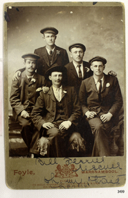 Flagstaff Hill Maritime Museum and Village
Postcard - People, Bill Ferrier - rescuer, 11th November, 1905
The postcard shows a photograph of William Ferrier, the 25-year-old Warrnambool fisherman from South Warrnambool whose rescue of two sailors from the wrecked La Bella made him an overnight National hero, quoted as “one of the most heroic rescues in Victoria’s shipwreck history”. The La Bella was wrecked on 10th November 1905 and the photograph was taken on the next day. In the photograph, William Ferrier is seated in the centre, with four of the five survivors beside him: (from left to right) Leonard Robertson, R. Payne, Oscar Rosenholme and Jack Noake. The photograph was taken by Foyle Photography Studio in Warrnambool, originally owned by James Charles Foyle. He previously had a photographic studio in Melbourne 1882 1887, then opened “Foyle’s Photo Card Studios” in Liebig St, Warrnambool. James Foyle died on 13th July 1905 and his son and daughter, Charles and Lilian Foyle continued on with the business until 1945. This photograph was most likely taken by either Charles or Lilian Foyle. The story of William Ferrier’s brave act follows on below … The ship from which the sailors were rescued was the three-masted, iron and steel barquentine the La Bella, built in Norway in 1893. She was one of two iron and steel ships by Johan Smith, the company was one of the leading shipping families in Tvedestrand, Norway. She was significant to Norwegian shipping, being one of only 27 iron and steel ships ever built in Norway. She was registered in New Zealand and engaged from 1902 in inter-colonial trading of timber in the Pacific, between New Zealand and Australia and was often in Port Phillip Bay, Victoria. On 5th October 1905, the twelve-year-old La Bella left Lyttleton, New Zealand carrying a cargo of timber bound for Warrnambool, Australia. She was manned by a crew of twelve: the Master, (Captain Mylius, previously 1st Mate of La Bella, appointed Captain to La Bella on 6th February 1903) 2 Mates, Cook, six able seamen, one ordinary seaman and a boy. Bad weather en route caused her to shelter at Burnie on Tasmania's North West coast. On November 10th, the 37th day of her journey, La Bella approached Warrnambool. Captain Mylius steered her towards Lady Bay Channel in heavy south-west seas and evening mist. He ordered the helmsman to steer for the light. As the ship came round, a tremendous sea struck her on the port quarter, causing her to breach broadside in a northwesterly direction into breakers. The helm was brought round twice more, but each time heavy seas broke over her, the third time throwing the La Bella on to a submerged reef in Lady Bay now known as La Bella Reef (about 100 yards from the Warrnambool breakwater). The sea was so rough that it even wrenched a one-and-a-half ton anchor from its fastenings and into the sea. As Captain Mylius headed to the steel wheelhouse, intending to send up a rocket flare, a huge sea slammed the steel door into him (resulting in massive bruising front and back) Despite his injuries he still managed to set off a blue light, which he held up in his hands. La Bella’s lifeboats were filled with seawater and broke up on their chocks. The blue light was the first indication to people on the shore that there was a ship in distress. The Harbour Master, Captain Roe (who lived in the Harbour Master’s House opposite Flagstaff Hill), organised a group of volunteers to crew the lifeboat because the trained crew was unavailable; the crewmen were working on a steamer in Port Fairy at the time. He then poured oil onto the water to try and smooth the sea. At around 11 pm three of the crew took shelter in the steel forecastle but the sea crashed into it and broke it up. While the rest of the crew and onlookers watched helplessly in the moonlight the bodies were washed away into the sea, never to be seen again. Some of the crew lashed themselves to the weather rail to keep from being washed away. Watson, the ordinary seaman, became tangled in the rigging lines and was too weak to move, so the 2nd Mate, Robertson, put a line onto him so that he wouldn’t wash off. Around 11 pm three of the crew were unconscious from exhaustion. The situation on La Bella was becoming dangerous. The 2nd Mate moved to the ‘house’ and soon afterwards the ship slipped in the heavy sea. The lashings of the 1st Mate and the ‘boy’ Denham had kept them safe until about 2 am when they were washed overboard; no one was able to help. One by one, the exhausted crew were being washed overboard, too weak to hold on any longer. During the night the La Bella had broken into two and the deckhouse ran out towards the sea. Two more men drowned when trying to reach the lifeboat. By sunrise, the only survivors of the twelve were the Master, 2nd Mate and three seamen. Early in the morning, Captain Roe used the rocket apparatus on shore to try and shoot a line to the ship for a safer rescue but each attempt fell short of the target. Several attempts were made by the lifeboat to rescue the stricken sailors, but the rough conditions made this difficult for the boat to get close enough to the ship and the lifeboat had to return to shore. During a final attempt to reach the ship Captain Mylius ordered his men to jump into the sea. Leonard Robertson, 2nd mate, jumped and swam towards the lifeboat, taking hold of the boat hook offered to him. Oscar Rosenholme managed to reach the boat floating on a piece of timber from the ship’s load and a third survivor, Noake, also made the boat. Along with the lifeboat rescue crew, 25-year-old William Ferrier rowed his small dingy through the heavy seas and managed to rescue the Captain, whom he landed on the breakwater. Ferrier then returned to the ship to attempt a final rescue, losing his oars and rowlocks into the high sea. Using just a spare paddle he skulled towards the La Bella, reaching her stern in time to cut loose the lone surviving sailor, Payne, from the lashing that held him to the ship; the terrified sailor dropped from the ship and into the dingy. Shortly after the last man was rescued, the La Bella was lifted by a huge wave and crashed back down on the reef; she broke up and sank. The ordeal had lasted ten hours. The survivors were taken to the nearby Bay View Hotel and gratefully received warm food and clothing, medical attention and a place to sleep. In the following days, an unidentified body of a young person had washed ashore; it was either Watson or Denham. The body was buried in the Warrnambool cemetery with an appropriate gravestone and inscription. William Ferrier became a national hero as news of the daring rescue spread. In recognition of his bravery in the two daring rescues, he was awarded the Silver Medal for Bravery by the Royal Humane Society and was honoured in the letter from the Prime Minister and the Parliament of the Commonwealth, telegrams and a cheque for £20 from the Governor-General, over £150 subscribed by the public, including Warrnambool and district and readers of The Argus, and a gold medal from the Glenelg Dinghy Club of South Australia. Ferrier’s rescue efforts are one of the most heroic in Victoria’s shipwreck history. (William Ferrier’s son, Frank, received a similar award almost fifty years later when he helped rescue four members of the crew on the yacht Merlan after it ran on to a reef near the Point Lonsdale Lighthouse. ) The wreck of La Bella now lies on her port side in 13 metres of sheltered water inside the reef she struck. The bow section is relatively intact and part of the stern has drifted north-easterly towards the mouth of the Hopkins River. The reef the La Bella struck now bears its name. Those five rescued from the La Bella were Captain George Mylius, Leonard Robertson (2nd Mate, 21 years old), R. Payne, Oscar Rosenholme and Jack Noake. Those seven who lost their lives were Mr Coulson (1st mate), Charles Jackman (cook) Gustave Johnson, Pierre Johann and Robert Gent (all able seamen), Harry Watson (ordinary seaman) and Jack Denham (ship’s boy), Captain Mylius was found guilty of careless navigation; he had sailed into the bay without the services of a pilot. His Master Certificate was suspended for twelve months. Later he was also charged with manslaughter of one of the crew who had died when the La Bella was wrecked but found not guilty. The event’s adverse publicity and damage to his career took a toll on his health and he died of a heart attack six months after the wreck; he was only thirty-seven. His body was buried in the Melbourne General Cemetery. The La Bella was “the best documented of all sailing ships owned in New Zealand”. Her record books, ship logs, correspondence and supporting papers are still available. At the time of the tragedy, she was owned by Messers David C.Turnbull and Co. of Timaru, New Zealand timber merchants and shipping agents, who had purchased her on 13th December 1901. A detailed account of the last journey of La Bella can be read in “Leonard Robertson, the Whangaroa & La Bella” written by Jack Churchouse, published in 1982 by Millwood Press Ltd, Wellington, NZ. As well as this postcard, Flagstaff Hill’s La Bella Collection includes a photograph of the wrecked La Bella, a brass rail holder and the letter from the Prime Minister and other Members of Parliament that was sent to William Ferrier to commend him for his bravery. Some 15 – 17 ships are believed to have sunk in Lady Bay, but only two have been discovered on the seafloor; the “La Bella” and the “Edinburgh Castle”. Both wrecks are popular diving sites and are preserved as significant historical marine and marine archaeological sites. This postcard is part of the La Bella Collection and is significant at both a local and state level. Its connection to the La Bella shipwreck and the rescue of five survivors highlights the dangers of Victoria’s Shipwreck Coast. The photograph of William Ferrier and four of the five survivors demonstrates the bravery of ordinary Australians who risked their lives to save victims of shipwrecks along the coast. The postcard is significant to the history of Warrnambool as it portrays William Ferrier, a local fisherman whose descendants continue to live in the area. It highlights the way of life of people who lived in coastal towns in 19th century Victoria and the effects of shipwrecks upon them. The postcard connects to the congratulatory letter which was sent to William Ferrier by the Prime Minister and Government of Australia and demonstrates the importance they attached to his efforts for Victoria and to Australia. The postcard is also an example of the photography of Foyle Photographers who were in the town of Warrnambool from the late 1800’s. Charles and Lillian Foyle took over the business when their father James died in 1905. Lillian Foyle is significant as the first woman photographer in Warrnambool. It is not known whether Charles of Lillian took this photograph. This postcard is significant because of its association with the sailing ship “La Bella”. The “La Bella” is of local and state and national significance. It is one of the only two shipwrecks discovered in Lady Bay, Warrnambool, out of the 15-17 shipwrecks in the bay. Sepia photograph of William (Bill) Ferrier (seated in the middle), heroic rescuer of two crew members of the La Bella, wrecked at Warrnambool. The photograph is a postcard and shows five men dressed formally in suits and hats. Printed below the photograph are the name and place of the photographer, a royal crest and the details of two patrons of the photographer. Also below the photograph are some handwritten words in black pen. On the back of the postcard is a handwritten message in the same writing as the front.Printed on the front of the card is “Foyle, WARRNAMBOOL” “PATRONS: / HIS ROYAL HIGHNESS THE DUKE OF CORNWALL & YORK. / HIS EXCELLENCY LORD BRAS_ EY, R.O.B.” Handwritten on the front of the card is “Bill Ferrier / rescuer / Oh my hero _ _ _ “ Handwritten on the back of the card is a message. “La Bella” Wrecked off W.Bool Breakwater Nov. 1906 (_ _ _ _ show night) Payne Noake Rosenholme Robertson and Capt Mylius (saved) (moonlight bright) Watson (_ _ _ _ boy) Richwoud [possibly Richmond] drowned” and signed “Desdewoua [possibly Desdemona] Slogos”la bella, foyle, william ferrier, bill ferrier, lady bay, 1905, 10th november 1905, 11th november 1905, parliament of the commonwealth, royal humane society medal, flagstaff hill, warrnambool, shipwrecked coast, flagstaff hill maritime museum, maritime museum, shipwreck coast, flagstaff hill maritime village -
 Ballarat Heritage Services
Photograph - Digital photographs, L.J. Gervasoni, St Brigid's Crossley - stained glass window, 2016
"LARGE GATHERINGNG AT - CROSSLEY DEDICATION AND OPENING SERVICES. SERMON BY DR. MANNIX. Yesterday was an important and historic day for the Roman Catholic community of Crossley and Koroit, in as much as it will be always associated in the memories of all con cerned with the opening of the new St. Brigid's Church, Crossley. This building is far above the average standard of sacred edifices in country towns, and is certainly superior to any ercted in this district outside the churches in the two larger centres - Warrnambool and Koroit. The style of architecture chosen is a free treatment of the Romanesque, which is something quite original in the Western District. This noble style, from which, with its near re lative the Byzantine, spring the great Gothic school of architecture, is characterised by a special charm of its own, one of its chief features being graceful and sweeping circular curves in roof, window heads and in the ar rangenent of the ground plan. The building is of brick finished off with true Romanesqiue pillared pinnacles in concrete and plaster, the brick and concrete producing a pleasing contrast. The main characteristic of the front is a large rose window filled with Romlanesque circular tracery, and below a bold porch and entrance. The two sides are pierced with long circular-headed windows between graceful buttresses and the wall line is pleasingly broken by the projecting bays of the confessionals and also by the vestries. The main building is 80 feet by 30 feet' and the Sanctuary is spacious and semi-circular in shape, and lighted by three windows. The interior of the church is most artistic. The ceiling is semi-circular and of fibrous plaster in ornate designs. All the windows are lead lighted, throwing a rich and mellow harmony of' color throughout the interior and the white wails, mouldings, architraves and other fibrous plaster decorations: are further relieved by the rich coloring: in the stations of.the Cross arrranged around the nave. The central window of the Sanctuary contains a splendidly executed stained glass representation of St. Brigid. At.the western end is a room gallery. The altar is a choice piece of Gothic woodwork, in light, soft coloring, and there are two altars on either side of the Sanctuary in oak, and above whlch are very fine colored figures of Christ; and the Madonna. On either side of the altar are life-size figures of angels holding high brass candalabra. The whole of the furnishings of the church are on a sumptuous scale, and the edifice reflects credit on all concerned. The church can seat nearly 500 people. The architect was Mr. A. A. Fritsch. of Melbourne, and the contractors Messrs F. and E. Deagne, of North Fitzroy. The contract price for the building was £5,500. THE OPENING SERVICE. After the cereimony of solemnly blesssing the church was performed by His Lordship the Bishop of the Diocese, Dr. Higgins, assisted by His Grace the Coadjutor Archbishop of Melbourne. Dr. Mannix, the great gatheiring from all parts of the district entered the church, which was soon completely filled. The members of the H.A.C.B.S. attended wearing their green and gold regalia, and acted as a 'guard of honor' to the Co-adjlutor Arclhbishop and Bishop. Mass was celebrated by the Rev. Father Phelan, of Koroit, and a feature of the solemn service was the singing of a choir which consisted of picked voices from St. Carthage's choir, with friends from Warrnam bool and assisted by some of the mem bers of the Koroit choir, with Miss Logan as organist and Mr. Arthur H. Renwick as conductor. They rendered the music in splendid style throghonut. The "Kyrie," "Gloria." "Agnus Dei' and Dona Nobis" were from Farmer's Mass in B flat, and the "Credo" and "Sanctus" from Webbe's Mass in G. The soloists in the Mass were Mrs. Ryan, the Misses McEntee. Miss Katie O'Brien. and Messrs. J. M. Crowley, W. J. Callaghan; B. McEntee and W. Mahony. The chorus sang with great precision, special attention being paid to at tack. At the offertory Mrs. Dan Ryan gave a beautiful rendering of Gounod's "Ava Maria." After the Elevation that fine duet "Tantum Ergo." by Rossi, was sung by Messrs. Crowley and Renwick in an artistic manner, their fine voices blending splendidly. During the collection, Mr. Renwick sang with much feeling that devotional solo, "Lead Thou Me On,", after which Mr Crowley gave .an ex cellent rendering of Weissi's "0 Salu taris Hostia;" and the choir sang several hymns." It might here be mentioned that at the request of Fa ther Kerin, the same choir will repeat the music.at the Koroit Church on Sunday next, on the occasion of the ceremnly of laying the foundation stone of the cormpletion of the church. Dr. Mannix preachled the sermon for the occasion, taking his text from St. Luke first 11 verses. He re viewed the Gospel story of Christ preaching to the multitude from a boat on Lake Gennesaret and the miraculous draught of fish. The obedi ence of the poor fishermen in casting their nets at Christ's bidding was richly rewarded, and the miraculous occurrence was a striking example of what was to happen when Christ established His Church and built it up on those twelve apostles. When they came to think of it, nothing so re markable and marvellous had happened before or since in the history of mankind. The world at that time was for the most part a Pagan world steeped in iniquity and sin. The chosen people of God had God's re velation, but they worshipped with their lips and not with their hearts. When Christ was to establish His Church upon earth and leave an or gantisation that would continue His work, did He select learned men, powerful men, rich men, or a time that would seem propituous? No. He selected twelve poor, igorant simple fishermen, without money, power, learning or anything calculated to enable them to do anything striking in the world's history. The success of the first morning after pentecost was not confined to those first days when the plentitude of the Holy Ghost sat upon the .Apostles, but it continued age after age until the whole world was brought within the sphere of ac tion of the Church. Greece, Rome Europe Asia and America, and now Australia had been brought into the net. This must be a consolation to them all as well as it was to him (the preacher), when they remembered that they came from a land which of all others had been faithful to the Gospel of Jesus Christ. It was a consolation to them that in that great work that had been accomplished in bringing men into the meshes of the Church, and bringing them to God the nation to which they belontged had taken so great a part. Their religion flourished in England, Scotland, America and Australia. Surely it was due to the sons of St. Patrick, the sons and daughters of Ireland to find consolation in these great facts might It might seem hard that so many had to leave their native-land for England, Scotland, America and Australia. But if hard it was the means of keeping the Catholic faith living in England and Scotland. If to-day the Irish Catholics and Catholics of Irish de scent were taken out of the English and Scotch population there would be little left of the true Church of God. It seemed hard to emigrate to distant lands, but the result had been the new magnificent church in the United States, the flourishing churches in Canada and South Africa. Those Irish emigrants were a cornparatively small band. Perhaps they had not the learning of other nations. Certainly they had not the wealth and it did not fall to their lot to have the power of the sword, but God was with them, and the faith they took from Ireland flourished in those distant lands. In this fair land of Australia they had a glorious herit age handed down from the pioneer Irish Catholics, who came to this fair Austral land. There was a time when those who were opposed to God and God's Church,thought that Australia should be a wholly Protestant land. They had lived to see whether God or His enemies were the stronger. They had lived to see that those who in distant days would have stamped out the Catholic religion in Australia, had not prevailed. Their names had been forgotten because of their persecution of the Catholic Church, and they had lived - to see the glorious success that now, in every part of the Common wealth, rested upon the Catholic Church in Australia. Might God bless that Church and those Irish people, and the people of Irish descent, who had built it up. In that locality, and there was no place in.the Common wealth where the Catholic Church was held in higher esteem, the people would always be faithful to God and His Church. That beautiful building, and all it signified in loyalty and faithfulness, was a credit and a consolation to the Bishop and people of the diocese, to the architect who had done his work so artistically and skil fully. to the priests and the zealous administration of the parish. There was surely hope and inspiration in that day's celebration, that as time went on the Catholic faith would sink deeper and deeper into ther coming generation, and that the Catholic progress of the past 50 years would be small in comparison to the great progress of the future. He congratulated the Bishop priests and people who had raised that temple. He congratulated the people of Crossley; upon their generosity and self-sacrifice, and he prayed that God's blessing and the blessing of St. Brigid would rest upon them; their children and children's children. And when those who had received the sacraments and had been instructed in that Church were called before the Judgment Seat he pray ed that not one would be missing, and St. Peter aind St. Brigid would be able to count them all into the en joyment .of Eternal bliss. THE CELEBRATION The Rev. Father Kerin, Adninistra tor of the Parish, after the collection, read a lengthy list of the principal donations, headed by the Bishop, Dr. Higgins, with £250. All the furnish ings of the Church were also donations, and the Coadjutor-Archbishop added £5 to the list. The Rev. Father Kerin stated that the total to hand was £1245/10/7, which was an other proof of the generosity of the Crossley and district people. The amount previously received in donations was £1077/3. They started buildiing with a credit balance of £262 10/5 and ther now had a debit balance of £2,728/18/5. The total cost of the Church was £6,250, so that they would see the greater part of the indebtedness had already been wiped out. The Bishop (Dr. Higgins) delivered a brief address, in the course of which he congratulated the priests and people upon the completion of their magnificent Church. He congratulated the people on their magnificent generosity. He expressed his of deep indebtedness to the Coadjutor Archbishop of Melbourne for the services he had rendered to them. He had attended at considerable sacrifice to himself, and they were extremely grateful for the presence of so distinguished a champion who had shown such zeal and interest in their Church in this new land. He (the Bishop) trusted that his splendid talents would long be devoted to the defence of the Church." (Warrnambul Standard, 02 July 1914)Digital images of the stained glass windows at St Brigid's, Crossley.victoria, crossley, st brigid's crossley, st brigid's, catholic church, catholic, church, religion, stained glass, window -
 Ballarat Heritage Services
Digital photographs, St Brigid's Crossley - Christmas Carols, 2016, Christmas 2016
"LARGE GATHERINGNG AT - CROSSLEY DEDICATION AND OPENING SERVICES. SERMON BY DR. MANNIX. Yesterday was an important and historic day for the Roman Catholic community of Crossley and Koroit, in as much as it will be always associated in the memories of all con cerned with the opening of the new St. Brigid's Church, Crossley. This building is far above the average standard of sacred edifices in country towns, and is certainly superior to any ercted in this district outside the churches in the two larger centres - Warrnambool and Koroit. The style of architecture chosen is a free treatment of the Romanesque, which is something quite original in the Western District. This noble style, from which, with its near re lative the Byzantine, spring the great Gothic school of architecture, is characterised by a special charm of its own, one of its chief features being graceful and sweeping circular curves in roof, window heads and in the ar rangenent of the ground plan. The building is of brick finished off with true Romanesqiue pillared pinnacles in concrete and plaster, the brick and concrete producing a pleasing contrast. The main characteristic of the front is a large rose window filled with Romlanesque circular tracery, and below a bold porch and entrance. The two sides are pierced with long circular-headed windows between graceful buttresses and the wall line is pleasingly broken by the projecting bays of the confessionals and also by the vestries. The main building is 80 feet by 30 feet' and the Sanctuary is spacious and semi-circular in shape, and lighted by three windows. The interior of the church is most artistic. The ceiling is semi-circular and of fibrous plaster in ornate designs. All the windows are lead lighted, throwing a rich and mellow harmony of' color throughout the interior and the white wails, mouldings, architraves and other fibrous plaster decorations: are further relieved by the rich coloring: in the stations of.the Cross arrranged around the nave. The central window of the Sanctuary contains a splendidly executed stained glass representation of St. Brigid. At.the western end is a room gallery. The altar is a choice piece of Gothic woodwork, in light, soft coloring, and there are two altars on either side of the Sanctuary in oak, and above whlch are very fine colored figures of Christ; and the Madonna. On either side of the altar are life-size figures of angels holding high brass candalabra. The whole of the furnishings of the church are on a sumptuous scale, and the edifice reflects credit on all concerned. The church can seat nearly 500 people. The architect was Mr. A. A. Fritsch. of Melbourne, and the contractors Messrs F. and E. Deagne, of North Fitzroy. The contract price for the building was £5,500. THE OPENING SERVICE. After the cereimony of solemnly blesssing the church was performed by His Lordship the Bishop of the Diocese, Dr. Higgins, assisted by His Grace the Coadjutor Archbishop of Melbourne. Dr. Mannix, the great gatheiring from all parts of the district entered the church, which was soon completely filled. The members of the H.A.C.B.S. attended wearing their green and gold regalia, and acted as a 'guard of honor' to the Co-adjlutor Arclhbishop and Bishop. Mass was celebrated by the Rev. Father Phelan, of Koroit, and a feature of the solemn service was the singing of a choir which consisted of picked voices from St. Carthage's choir, with friends from Warrnam bool and assisted by some of the mem bers of the Koroit choir, with Miss Logan as organist and Mr. Arthur H. Renwick as conductor. They rendered the music in splendid style throghonut. The "Kyrie," "Gloria." "Agnus Dei' and Dona Nobis" were from Farmer's Mass in B flat, and the "Credo" and "Sanctus" from Webbe's Mass in G. The soloists in the Mass were Mrs. Ryan, the Misses McEntee. Miss Katie O'Brien. and Messrs. J. M. Crowley, W. J. Callaghan; B. McEntee and W. Mahony. The chorus sang with great precision, special attention being paid to at tack. At the offertory Mrs. Dan Ryan gave a beautiful rendering of Gounod's "Ava Maria." After the Elevation that fine duet "Tantum Ergo." by Rossi, was sung by Messrs. Crowley and Renwick in an artistic manner, their fine voices blending splendidly. During the collection, Mr. Renwick sang with much feeling that devotional solo, "Lead Thou Me On,", after which Mr Crowley gave .an ex cellent rendering of Weissi's "0 Salu taris Hostia;" and the choir sang several hymns." It might here be mentioned that at the request of Fa ther Kerin, the same choir will repeat the music.at the Koroit Church on Sunday next, on the occasion of the ceremnly of laying the foundation stone of the cormpletion of the church. Dr. Mannix preachled the sermon for the occasion, taking his text from St. Luke first 11 verses. He re viewed the Gospel story of Christ preaching to the multitude from a boat on Lake Gennesaret and the miraculous draught of fish. The obedi ence of the poor fishermen in casting their nets at Christ's bidding was richly rewarded, and the miraculous occurrence was a striking example of what was to happen when Christ established His Church and built it up on those twelve apostles. When they came to think of it, nothing so re markable and marvellous had happened before or since in the history of mankind. The world at that time was for the most part a Pagan world steeped in iniquity and sin. The chosen people of God had God's re velation, but they worshipped with their lips and not with their hearts. When Christ was to establish His Church upon earth and leave an or gantisation that would continue His work, did He select learned men, powerful men, rich men, or a time that would seem propituous? No. He selected twelve poor, igorant simple fishermen, without money, power, learning or anything calculated to enable them to do anything striking in the world's history. The success of the first morning after pentecost was not confined to those first days when the plentitude of the Holy Ghost sat upon the .Apostles, but it continued age after age until the whole world was brought within the sphere of ac tion of the Church. Greece, Rome Europe Asia and America, and now Australia had been brought into the net. This must be a consolation to them all as well as it was to him (the preacher), when they remembered that they came from a land which of all others had been faithful to the Gospel of Jesus Christ. It was a consolation to them that in that great work that had been accomplished in bringing men into the meshes of the Church, and bringing them to God the nation to which they belontged had taken so great a part. Their religion flourished in England, Scotland, America and Australia. Surely it was due to the sons of St. Patrick, the sons and daughters of Ireland to find consolation in these great facts might It might seem hard that so many had to leave their native-land for England, Scotland, America and Australia. But if hard it was the means of keeping the Catholic faith living in England and Scotland. If to-day the Irish Catholics and Catholics of Irish de scent were taken out of the English and Scotch population there would be little left of the true Church of God. It seemed hard to emigrate to distant lands, but the result had been the new magnificent church in the United States, the flourishing churches in Canada and South Africa. Those Irish emigrants were a cornparatively small band. Perhaps they had not the learning of other nations. Certainly they had not the wealth and it did not fall to their lot to have the power of the sword, but God was with them, and the faith they took from Ireland flourished in those distant lands. In this fair land of Australia they had a glorious herit age handed down from the pioneer Irish Catholics, who came to this fair Austral land. There was a time when those who were opposed to God and God's Church,thought that Australia should be a wholly Protestant land. They had lived to see whether God or His enemies were the stronger. They had lived to see that those who in distant days would have stamped out the Catholic religion in Australia, had not prevailed. Their names had been forgotten because of their persecution of the Catholic Church, and they had lived - to see the glorious success that now, in every part of the Common wealth, rested upon the Catholic Church in Australia. Might God bless that Church and those Irish people, and the people of Irish descent, who had built it up. In that locality, and there was no place in.the Common wealth where the Catholic Church was held in higher esteem, the people would always be faithful to God and His Church. That beautiful building, and all it signified in loyalty and faithfulness, was a credit and a consolation to the Bishop and people of the diocese, to the architect who had done his work so artistically and skil fully. to the priests and the zealous administration of the parish. There was surely hope and inspiration in that day's celebration, that as time went on the Catholic faith would sink deeper and deeper into ther coming generation, and that the Catholic progress of the past 50 years would be small in comparison to the great progress of the future. He congratulated the Bishop priests and people who had raised that temple. He congratulated the people of Crossley; upon their generosity and self-sacrifice, and he prayed that God's blessing and the blessing of St. Brigid would rest upon them; their children and children's children. And when those who had received the sacraments and had been instructed in that Church were called before the Judgment Seat he pray ed that not one would be missing, and St. Peter aind St. Brigid would be able to count them all into the en joyment .of Eternal bliss. THE CELEBRATION The Rev. Father Kerin, Adninistra tor of the Parish, after the collection, read a lengthy list of the principal donations, headed by the Bishop, Dr. Higgins, with £250. All the furnish ings of the Church were also donations, and the Coadjutor-Archbishop added £5 to the list. The Rev. Father Kerin stated that the total to hand was £1245/10/7, which was an other proof of the generosity of the Crossley and district people. The amount previously received in donations was £1077/3. They started buildiing with a credit balance of £262 10/5 and ther now had a debit balance of £2,728/18/5. The total cost of the Church was £6,250, so that they would see the greater part of the indebtedness had already been wiped out. The Bishop (Dr. Higgins) delivered a brief address, in the course of which he congratulated the priests and people upon the completion of their magnificent Church. He congratulated the people on their magnificent generosity. He expressed his of deep indebtedness to the Coadjutor Archbishop of Melbourne for the services he had rendered to them. He had attended at considerable sacrifice to himself, and they were extremely grateful for the presence of so distinguished a champion who had shown such zeal and interest in their Church in this new land. He (the Bishop) trusted that his splendid talents would long be devoted to the defence of the Church." (Warrnambul Standard, 02 July 1914)Digital images of the interior of St Brigid's, Crossley.st brigid's crossley, st brigid's, catholic church, catholic, church, religion, celebrations, christmas, christmas carols, carols, stained glass, window