Showing 1180 items matching "victoria point"
-
 Glen Eira City Council History and Heritage Collection
Booklet, "AVENUES OF HONOUR The Councils of the Municipalities of the CITY OF CAULFIELD TOWN OF BRIGHTON acting in conjunction PUBLIC DEMONSTRATION SAT 3rd AUG. 1918 AT 3oCLOCK"
Souvenir Programme from the Councils of the Municipalities of the City of Caulfield and the Town of Brighton for a Public Demonstration to be held on Sat 3rd August 1918 at 3 o'clock for the proposed Avenues of Honour to be planted in memory of fallen WWI soldiers. From Honour Roll Display 2019 interpretation panel - Brighton-Caulfield Avenue of Honour It is hard to imagine but a grand arboreal Avenue of Honour once lined parts of North Road, McMillan Street and Point Nepean Road (now Nepean Highway). The Avenue of Honour was a distinctly Australian phenomenon with hundreds being constructed throughout Australia during and following World War One, most of these in Victoria. Consisting of tree lined streets with each tree representing a solider, the Avenue of Honour signalled a more egalitarian approach to commemoration where rank was not a consideration. Arguably the most famous Avenue of Honour in Victoria still exists at Ballarat. Stretching for nearly 22 kilometres, the entrance to the Avenue is marked by the imposing Arch of Victory. Smaller in scale, the Brighton-Caulfield Avenue of Honour was dedicated to the ‘memory of (Brighton and Caulfield’s) kith and kin who came from (the) district and who died in the Great War’. A joint project between the neighbouring Councils, the idea was first reported in The Argus on 1 July 1918. Plans moved along quickly and on 3 August 1918 the Governor of Victoria Arthur Stanley planted the first Australian flowering gum. The next of kin were then invited to plant trees for lost sons, brothers, uncles, nephews and husbands. In all, over 400 trees were planted. Intensely personal, the Avenue also acted as a focus of grief and remembrance for the wider community. For many years, the annual civic Anzac Day service was held at the Avenue on Point Nepean Road, near Glen Huntly Road, Elsternwick. The service was moved to Caulfield Park upon the completion of the Cenotaph in 1930. Due to road widening and disease the last original tree was replaced in the 1980s, however a plaque in Caulfield Park records the Avenue’s plantation. Commemorative booklet, grey cover with text printed on the grey textured paper cover and an image of four trees and a wreath. Image of a kookaburra on the back. Inside, 28 numbered pages with b/w text and photographic images including a transparent paper representation of the proposed Avenues of Honour on Brighton Road and Point Nepean Road. Souvenir programme for a Public Demonstration for the Avenues of Honour as detailed on the front.city of caufield, world war one, first world war, anzac, remembrance, town of brighton, brighton, caulfield, avenue of honour -
 Glen Eira City Council History and Heritage Collection
Booklet, D. W. Paterson Co. Pty. Ltd, "AVENUES OF HONOUR The Councils of the Municipalities of the CITY OF CAULFIELD TOWN OF BRIGHTON acting in conjunction PUBLIC DEMONSTRATION SAT 3rd AUG. 1918 AT 3oCLOCK SOUVENIR"
Souvenir Programme from the Councils of the Municipalities of the City of Caulfield and the Town of Brighton for a Public Demonstration to be held on Sat 3rd August 1918 at 3 o'clock for the proposed Avenues of Honour to be planted in memory of fallen WWI soldiers. One of two known copies, this copy has "Town Clerk" stamped in the upper corner, rhs.Commemorative booklet, grey cover with text printed on the grey textured paper and an image of four trees and a wreath. Image of a kookaburra on the back. Inside, 28 numbered pages with b/w text and photographic images including a transparent paper representation of the proposed Avenues of Honour on Brighton Road and Point Nepean Road. Souvenir programme for a Public Demonstration for the Avenues of Honour as detailed on the front. From Honour Roll Display 2019 interpretation panel - Brighton-Caulfield Avenue of Honour It is hard to imagine but a grand arboreal Avenue of Honour once lined parts of North Road, McMillan Street and Point Nepean Road (now Nepean Highway). The Avenue of Honour was a distinctly Australian phenomenon with hundreds being constructed throughout Australia during and following World War One, most of these in Victoria. Consisting of tree lined streets with each tree representing a solider, the Avenue of Honour signalled a more egalitarian approach to commemoration where rank was not a consideration. Arguably the most famous Avenue of Honour in Victoria still exists at Ballarat. Stretching for nearly 22 kilometres, the entrance to the Avenue is marked by the imposing Arch of Victory. Smaller in scale, the Brighton-Caulfield Avenue of Honour was dedicated to the ‘memory of (Brighton and Caulfield’s) kith and kin who came from (the) district and who died in the Great War’. A joint project between the neighbouring Councils, the idea was first reported in The Argus on 1 July 1918. Plans moved along quickly and on 3 August 1918 the Governor of Victoria Arthur Stanley planted the first Australian flowering gum. The next of kin were then invited to plant trees for lost sons, brothers, uncles, nephews and husbands. In all, over 400 trees were planted. Intensely personal, the Avenue also acted as a focus of grief and remembrance for the wider community. For many years, the annual civic Anzac Day service was held at the Avenue on Point Nepean Road, near Glen Huntly Road, Elsternwick. The service was moved to Caulfield Park upon the completion of the Cenotaph in 1930. Due to road widening and disease the last original tree was replaced in the 1980s, however a plaque in Caulfield Park records the Avenue’s plantation. Inkstamp upper corner rhs: "TOWN CLERK" -
 Hand Tool Preservation Association of Australia Inc
Point
This item is part of the Thomas Caine Tool Collection, owned by The National Trust of Australia (Victoria) and curated by the Hand Tools Preservation Association of Australia.point, marker / scraper ? -
Hand Tool Preservation Association of Australia Inc
Compass
This item is part of the Thomas Caine Tool Collection, owned by The National Trust of Australia (Victoria) and curated by the Hand Tools Preservation Association of Australia.compass, arm, lead or point holder -
Hand Tool Preservation Association of Australia Inc
Saw
This item is part of the Thomas Caine Tool Collection, owned by The National Trust of Australia (Victoria) and curated by the Hand Tools Preservation Association of Australia.saw, rip, 3 1/2 point -
Hand Tool Preservation Association of Australia Inc
Saw
This item is part of the Thomas Caine Tool Collection, owned by The National Trust of Australia (Victoria) and curated by the Hand Tools Preservation Association of Australia.saw, rip, 3 1/2 point -
 Sunbury Family History and Heritage Society Inc.
Photograph, Bulla Primary School, Hanging Rock, 1995
In 1995, the upper school students from Bulla Primary School attended a camp at Hanging Rock Reserve which is part of the Macedon Ranges. At this camp the students were shown basic rock climbing skills and explored the rock for its interesting geological formations. Hanging Rock, also known as Mount Diogenes, is the traditional land of the Dja Dja Wurrung, Woi Wurrung and Taungurung people. It is a mamelon formed when magma poured from a vent and congealed. There are interesting rock functions at the site such as the Colonnade, the Eagle and the UFO. The highest point on the rock is 718metres above sea level and 105 meters above the land at its base.Hanging Rock is an important geological and volcanic structure in the Macedon Ranges area and in central Victoria. A non-digital coloured photograph of three holiday cabins and a barbecue in a bushland setting. A red car is parked outside one of the cabins as well as two permanent picnic tables.hanging rock, mount diogenes, mamelons, volcanoes, school camps, bulla primary school -
 Williamstown Botanic Gardens- Hobsons Bay City Council
Postcard - Williamstown Botanic Gardens, circa 1900-1924
The original postcards in this series (2013.002 to 2013.018) were generously loaned to Williamstown Botanic Gardens by a private collector for copying. The postcards are evidence of the interest the gardens held as a subject for postcard publishers. The text and images provide a snapshot into fashions, social interests and concerns of the time. The professionally produced images provide a pictorial history of Gardens including changing planting styles, various structures and features of the Gardens eg the aviary, cannons, the fountain, the second Curator’s Lodge and gates. The images offer an opportunity to compare garden vistas with the present day. This postcard is evidence of the placement of two of the cannons relocated from Fort Gellibrand in 1906 and that they were in place in the Gardens in 1924. They were removed from the Gardens in the 1960s. These same cannons remain a feature on the Williamstown waterfront in 2013. The image also shows the original Elm Avenue plantings. A sepia scene looking west towards statue of Alfred Thomas Clark, with cannons on either side of statue pointing east down what is known as the Palm Avenue. The statue is surrounded by a white fence consisting of posts and a top rail. The top of the statue is hidden by the branches of the elm trees. It appears that the elms are in the process of either losing their leaves or new leaf growth. A cactus plant can be seen beneath the lower branches of the elm tree of the right closest to the camera. The cannons were moved from Fort Gellibrand to the Gardens in 1906.Front: VALENTINE’S, M.356 ELM AVENUE WILLIAMSTOWN GARDENS MELBOURNE, VICTORIA. REAL PHOTO. Reverse: vertical on left side of card and underlined: ‘Published by the Valentine & Sons Publishing Co. Ltd. / Melbourne, Sydney & Brisbane’. Top centre of card: Contains logo of ‘VALENTINES / REAL PHOTO SERIES / POSTCARD’. Top right hand corner is stamped ‘BRANCHES (enclosed in a scroll) / SYDNEY / LONDON / DUNDEE / DUBLIN / CAPETOWN / MONTREAL / TORONTO’ The card is dated ‘29/12/24’ and addressed to ‘Dear Leah Alf & Dad’ signed by ‘Margaret’. postcard, gardens, post-card, williamstown-botanic-gardens, hobsons-bay-city-council, statue, clarke, alfred-thomas-clarke, cannon, elm, cactus, 1924, fort-gellibrand, 1906, armstrong, clark -
 Brighton Historical Society
Clothing - Dress, Day dress, circa 1878
This dress is of uncertain provenance. BHS records indicate that it was owned by Marion Jane Ellen Devlin, nee Stokes (1845-1936), who married Oliver Devlin on 2 April 1877 in Victoria. The dress is believed to have been worn on the Bendigo goldfields circa 1878. It may have been worn as a wedding dress. However, additional documentation discovered in August 2019 suggest that the dress belonged to Margaret Cocking, nee Carr (1850-1936), who married Gustavus Cocking in Bendigo in 1877.A grey-green circa 1878 dress comprising a matching jacket and skirt. The jacket (.1) features a standing collar that gathers to a low point at the throat. This point is concealed behind a bow with raw edges which may not be original. The centre front of the jacket has been secured with nineteen concealed metal hook and button holes. The centre front features fifteen sets of single fabric covered glass buttons secured in a diagonal pattern and appearing as double headed buttons. From the shoulder through the body the jacket is shaped with decorative panels with grey silk detail. Beside these panels shaping into the waist and under the arm are a further two pleats. On the left side waist is a small pocket with decorative flap, grey silk trim and button. The base line of the jacket features a decorative horizontal panel that wraps around the jacket. The sleeve head is small and sits on the natural shoulder line with a slim fitting, curved, full length sleeve. At the base of the sleeve, there is a decorative panel reminiscent of a formal cuff, with a decorative turn back and two buttons. Secured underneath this turn back is a bow like decoration. From the back the jacket features a V shaped decoration, an extension of the front two decorative panels. From the shoulders the jacket is shaped by four panels curving tight into the waist and flaring out again to fullness of the bustle. These seams are also finished with decorative binding. This peplum-like shape features two decorative flaps and six covered buttons. The skirt (.2) is shaped to the waist with pleats and secures on the front left hand side, the original waistband and fastenings have been replaced. The skirt front features a large decorative panel of the same fabric that curves from the front at approximately shin length, upwards towards the back securing underneath the bustle decoration. A second panel, plus a pleated panel finish the hem of the skirt continuing around to the back. At the back the skirt features two deep pleats with a large decorative bow that would sit out over the bustle. The skirt is long featuring a small train at the back. The dress is lined in a brown waxed cotton.wedding dress, 1870s fashion, marion jane ellen stokes, oliver devlin, margaret carr, gustavus cocking, bendigo -
 Brighton Historical Society
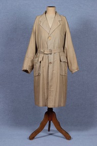
Coat, Dustcoat, c.1948
Dust coat worn by Mr Frederick Alister Jennings when he managed a family grocery store circa 1948 at 510 Point Nepean Road, East Brighton. Frederick was born at Nagambie, Victoria in 1909 and died in Brighton in 1979. He was the son of Hugh Edwin Jennings and Alice Constance Warren. He married Margaret Jean Hughes in 1934 and served in the Second World War. He lived at 1 Valda Grove Brighton. Frederick was a commercial traveller as well as his time spent managing the store in Point Nepean Road. It is believed this coat dates from his time at the store c1948 - 1955. The store was owned for many years by his father-in-law W. G. Hughes and was one of a group of shops near the corner of Centre Road. In 1944-45 the group of shops included Fletcher’s fuel merchants, a haberdasher, butcher, fruiterer, grocer, Brighton East post office, a ladies’ hairdresser and Hughes’ grocer. In 1950 Hughes’ grocery store was between a service station and the Commercial Bank on what had been renamed Nepean Highway. The business was sold to G. S. Maynard, grocer, sometime before 1960.Unlined dustcoat of beige cotton. Fastens centre front with three brown plastic buttons. Two large patch pockets. Separate cloth belt with metal buckle. Signs of wear and mending. .1 - coat .2 -beltGarment label reads: APEX (RLG.) Dust Coat DEPT. MYER STORE for MEN. MELBOURNE & ADELAIDEdustcoat, occupational dress, grocer, hughes grocery store, brighton, frederick alister jennings -
 Federation University Art Collection
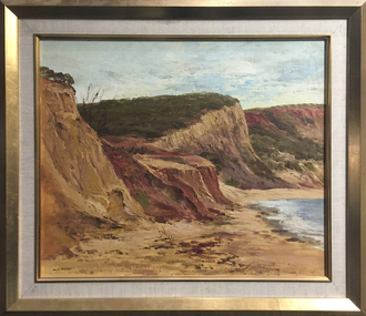
Painting - Oil on canvas board, 'Cliff Face' by R. Clayton Skate
... Framed landscape showing the cliffs at Point Addis near...) Born Newstead, Victoria This item is part of the Federation ...Ron SKATE (1913- 1991) Born Newstead, Victoria This item is part of the Federation University Art Collection. The Art Collection features over 1000 works and was listed as a 'Ballarat Treasure' in 2007.Framed landscape showing the cliffs at Point Addis near Anglesea, Victoria. signed l.l. 'Skate'art, artwork, ron skate, skate, r. clayton skate, landscape, available -
 National Communication Museum
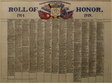
Memorabilia - Honour board, Roll of Honour 1914 - 1918, 1920
This honour board commemorates Victorian Postmaster General's Department workers who served in the First World War. A total of 3,726 employees of the Postmaster General's Department enlisted in the Australian Imperial Force during the First World War. This represented about one in every five of the total number of men employed by the Department. Many other employees volunteered, but were rejected for health or other reasons, whilst men in key positions could not be spared. This board was displayed at the Spirit of ANZAC Centenary Experience, Melbourne, in February 2016.This honour board was produced by the Postmaster-General's Department and passed through its successor entities until donation to the National Communications Museum in 2018. Its provenance is further supported by the supplementary photograph (VH256) held by the Museum which shows the board in production. The board provides a comprehensive list of the names of Postmaster-General staff across various departments, constituting an important resource for genealogical or social history researchers and a focal point for remembrance by fellow communications workers. The style of the board itself is rare, as it was an unusual practice for honour boards to be hand-lettered on paper.Handpainted paper on linen honour board, perspex glazed with a wooden frame."POSTMASTER GENERAL'S DEPARTMENT / VICTORIA" "ROLL OF HONOR / 1914 1918" "FOR / GOD / KING / AND / EMPIRE"|Headings that precede list of names: "CORRESPONDENCE / BRANCH" "CENTRAL EXCHE" "SUBURBAN AND COUNTRY / POST OFFICES" "TELEGRAPH / BRANCH" "ELECTRICAL ENGINEER'S BCH" "MAIL / BRANCH"pmg, postmaster general's department (pmg), world war 1, ww1, postal workers, honour boards, first world war -
 Vision Australia
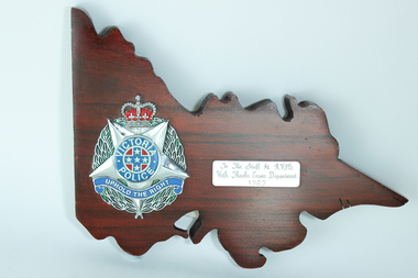
Photograph - Image, Victoria Police plaque, 1989
Wooden plaque in the shape of Victoria with the Victorian Police symbol (5 point star, surrounded by green leaves, topped with a red crown, round circle in the middle of the star containing the words 'Victorian Police' around a blue cross on a red background with 5 stars on the cross, and 'Uphold the Right' under the circle), to the left. The inscription to RVIB is on the right.Wooden plaque in shape of Victoria with police emblem on left sideTo the Staff of RVIB With Thanks Crime Department 1989royal victorian institute for the blind, nameplates -
Friends of Ballarat Botanical Gardens History Group
Work on paper - Victoria Park, Ballarat, A Brief Chronology 1861-1929, Unknown
A brief though useful chronology of Victoria ParkVictoria Park has featured in the history of Ballarat since 1861.1 page of large print in point form with a bullet for each point.Nonevictoria park, ballarat council, mining companies, arbor day, trees, clegg and nicholls, guilfoyle, f.w.niven, pinus radiata, friends of ballarat botanical gardens, john garner, doctor john garner, john garner collection, gardens, ballarat -
 Royal District Nursing Service (now known as Bolton Clarke)
Photograph - Photograph, black and white, c.1967
Mr. Bralsford,the Transport Manager at Royal District Nursing Service (RDNS), is instructing RDNS staff in the responsibilities of driving an RDNS vehicle. The Sisters were undergoing a Post Basic Course given by RDNS Educators, Car maintenance was necessary from 1937 when a car was donated by the Rotary Club to Melbourne District Nursing Society, (MDNS). Another car was donated, by General Motors-Holden, via the Duchess of Gloucester, in 1947, and the fleet began to grow from 1950 with seven Ford Prefects being provided by the Hospital and Charities Commission. For many years Melford Motors in South Melbourne maintained the MDNS fleet, until the fleet grew to the point of, the now named, Royal District Nursing Service (RDNS) providing its own Car Maintenance Division to service the cars regularly. The Royal Automobile Club of Victoria, (RACV), attended any breakdowns which occurred when nursing staff were on the road. Each new Sister employed by the Service was taken out for a driving test before she drove a District car. Royal District Nursing Service (RDNS) has had various modes of transport over the last 130 plus years. At first, from 1885 as Melbourne District Nursing Society (MDNS), their Trained nurses (Nurses) walked the streets and lane ways amid the slums of central Melbourne. As the Society expanded public transport was used; bicycles were bought by the Society in 1903 and used in inner areas until 1945. During the Spanish flu epidemic, in 1919, MDNS appealed for assistance to procure Motor vehicles so the Nurses could visit an influx of cases. Through trusts, grants and donations four 'Ford T Model' cars were procured which enabled the Nurses to triple their visits. Through constant use the cars were in such a poor state they were sold in 1927. A Motor Auxiliary was formed in 1929 to take Sisters to patients, and some Sisters used their own cars; even a motorcycle was used by one Sister in 1933. All these forms of transport were intermingled until, having received Royal patronage; the now Royal District Nursing Service (RDNS) had its own full fleet of vehicles by the mid 1960s. In many areas there were unsealed roads, in various conditions, which the Sisters negotiated to reach their patients to give care. Seat-belts had been introduced to Victoria in 1959 and District fitted them to their cars from 1962, even though they did not become compulsory until 1970. The Melways Directory of maps was introduced in 1966 which was a boon to the Sisters, though it was a few years before it went beyond Seville, so those that did the Warburton and Powelltown area worked off a large paper map. By 2009 there were 598 cars in the fleet and the Sisters travelled 9 million 200,000 kilometres – this is equivalent to 12 trips to the moon and back. Black and white photograph showing Mr. Bralsford instructing RDNS staff. In the left foreground is Sister (Sr) Liz Thomson who has her dark hair drawn back, is looking down at a piece of white paper resting on the arm of the wooden chair on which she is sitting. In front of her are the back views of Sr. Betty McDonald with curled dark hair and to her right is Sister Joanne Wilkinson. Mr. Bralsford, who has short dark hair; is wearing glasses, and wearing a grey coat, is standing in front of them pointing to a blackboard with his extended left arm and hand. He is looking down, and has his right hand on a piece of white paper on a desk. A strip heater is high on the left hand wall.Photographers stamp and Quote No. GW 101royal district nursing service, rdns, rdns transport, rdns education, melford motors, racv, sister liz thomson, sister betty mcdonald, sister joanne wilkinson, mr bralsford -
 Royal District Nursing Service (now known as Bolton Clarke)
Photograph - Photograph, black and white, Barry Sutton, 24.06.1971
Miss Evans, the Director of Nursing of Royal District Nursing Service (RDNS) is holding a meeting with some RDNS Sisters in a room at RDNS Headquarters, 452 St. Kilda Road, Melbourne. Mary Evans was born in Adelaide in 1915. She completed her General Nursing Training at the Royal Adelaide Hospital and her Midwifery Certificate at the Queen Victoria Memorial Hospital in Melbourne. Mary worked in the Midwifery section of Melbourne District Nursing Society from 1943–1945, and then qualified as a Maternal and Child Health Nurse. Gaining a Scholarship from MDNS in 1959, she studied and investigated District Nursing practices in England, Sweden, Denmark, Norway, Finland, Canada and the USA, which had a profound impact on the planning of MDNS. As Deputy Matron, then Matron from 1963, she began implementing her 5 point plan of - Education, Liaison, Ancillary Services, MDNS Centres in strategic areas and Home Health Aides. Miss Mary Evans retired as Director of Nursing of, the now, Royal District Nursing Service in 1978 and became an adviser to the Australian Council of Community Nursing Services. In 1981 she was awarded an O.B.E. for services to District Nursing, and as recognition for her leading role in Community nursing in Australia. From 1986-1990 she was heavily involved in the running of the Baxter Retirement Village. She was also Vice President of the Airdrie Retirement place for nurses in Canterbury. Mary Evans was placed on the Honour Roll of Victorian Women in 2001. Miss Mary Evan, O.B.E. died in early 2004.Black and white photograph of Miss Mary Evans, Director of Nursing of the Royal District Nursing Service (RDNS), with a group of RDNS staff. Miss Evans is sitting in a floral patterned lounge chair on the far right hand side. The other staff are sitting in a semi-circle in matching lounge chairs and couches. In attendance are Sisters: P. Holdsworth, B. Harris, E. Holland, M. Campbell, H. Beckett, J. Wilkinson, J. Tarn, E. Anderson. Some are partly hidden. Miss Evans has short dark curled hair and is wearing her grey uniform skirt and jacket. The rdns insignia can be seen on her upper left sleeve. The Sisters are wearing their grey short sleeve uniform frocks; some are wearing cardigans. The RDNS Insignia can be seen on the upper sleeve of some Sisters. A small round table with papers on it, sits beside Miss Evans and a rectangular coffee table in front of some of the Sisters. A plain carpet is on the floor and in the background two windows with long side curtains can be seen.Photographer Stamp. Quote No. 5 Aroyal district nursing service, rdns, rdns matron, miss mary evans, sister pat holdsworth, sister betty harris, sister e. holland, sister m. campbell, sister h. beckett, sister joanne wilkinson, sister joan tarn, sister ellen anderson -
 Carlton Football Club
Scrap Book, Dedicated to Carlton Player John Goold
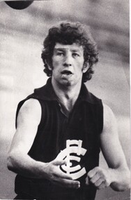
John Goold double Premiership PlayerA scrap Book dedicated to twice Premiership Player 1968 - 1970 John Goold Career : 1963 - 1970 Debut : Round 7, 1963 vs Footscray, aged 21 years, 338 days Carlton Player No. 754 Games : 108 Goals : 3 Last Game : Grand Final, 1970 vs Collingwood, aged 29 years, 90 days Guernsey No. 11 Height : 184 cm (6 ft ½ in.) Weight : 76 kg (12 stone, 0 lbs.) DOB : June 27, 1941 Premiership Player 1968, 1970 Carlton Hall of Fame All Australian 1966 A brilliant, flamboyant, two-time Premiership player for Carlton during the Barassi years in the ‘swingin’ sixties,’ John William Crosbie Goold became almost as famous for his dapper appearance off the field, as for his exploits on it. At the height of his football career, he was also a prominent ladies fashion designer – which led to him being dubbed ‘Mr Elegance’ by leading football commentator Lou Richards. Supporters and team-mates however, called him ‘Rags’ or ‘Ragsy,’ because of his involvement in the clothing, or ‘rag’ trade. Goold first came under notice as an outstanding junior athlete at Melbourne Grammar School. A true all-round sportsman, he shone at tennis, athletics, football and cricket. He was also a keen horseman who loved the game of polo and the rough and tumble of fox hunting. While at school he was a fervent Melbourne supporter, but strangely, never had much confidence in his football ability. “If I thought I was good enough, I would certainly have gone to Melbourne,” he said many years later. “But I honestly didn’t think I would ever amount to anything in this game. Cricket and tennis were the games that really interested me.’ However, after graduating from MGS, Goold went home to Healesville to star in the Bloods’ 1962 Yarra Valley Football Association Premiership team – an achievement that brought tempting offers from more than one VFL club. “Incentives were offered elsewhere,” he recalled, “but I gravitated to Carlton – partly because the deep blue of their guernsey attracted me, but mostly because of the good advice I got from people who even then were longsighted enough to predict that big things were ahead for this club.” The Blues were confident enough in Goold’s potential to offer him the guernsey number 11 previously worn with distinction by the likes of Jack Hale, Jim Knight, Ron Hines and Laurie Kerr, and his first senior game came in round 7, 1963 against Footscray at the Western Oval. He played on a half-forward flank alongside Brownlow Medallists Gordon Collis and John James on that Saturday afternoon, and kicked his first career goal in an 8-point win. Little did he know though, that it would be another six seasons before he would again experience the thrill of sending a football spinning between the big posts, because his future lay in defence. By his own admission, Goold struggled to find his feet in VFL football during his first two seasons, until the shock appointment of Ron Barassi as captain-coach of Carlton in 1965 began steering his career back on track. “I think you could say that 1965 was my first year of League football,” he said, “That’s the way I felt - that’s the way I reacted to Barassi.” Under Barassi, Goold rapidly developed into a superb running half-back flanker. Tenacious, and an often freakish high mark, he was unmistakable on the field thanks to his mane of dark hair, his loping running style and somewhat awkward kicking action. Furthermore, he had boundless courage. There is no doubt that he would have played many more games had he not been regularly pole-axed under the high ball – a fact he later freely admitted. “I was always getting knocked out,” he said, “and spent half my bloody time in hospital.” In the second half of 1965, an injury to centre half-back Gordon Collis forced Barassi to use Goold in the key defensive post. While it curtailed his rebounding instincts somewhat, ‘Ragsy’ rose to the challenge and rarely lowered his colours. Testament to his improvement, he finished third behind John Nicholls and Sergio Silvagni in Carlton’s 1965 Best and Fairest award, and followed up by being selected in the Victorian team for the 1966 Hobart Carnival. There, he had a superb series in which he was runner-up to West Australian Barry Cable in voting for the Tassie Medal, and capped it off by being named on a half-back flank in the All Australian team. Barassi’s influence at Carlton bore fruit in his third year, when the Blues returned to finals football at last. Richmond, Carlton, Geelong and Collingwood fought out the 1967 Premiership, and Ragsy Goold won the hearts of the Carlton faithful with two lion-hearted performances. Although Carlton was knocked out of contention by successive losses to Richmond and Geelong, Goold was tireless throughout both games, and it was obvious that he thrived on the added pressure of finals football. Precisely twelve months later, the bitter taste of those defeats was washed away when Barassi’s Blues edged out Essendon by 3 points in the 1968 Grand Final, and ended 21 years of despair at Princes Park. To win Carlton’s ninth VFL flag, the Blues had had to defeat the minor premier Bombers twice during the finals – and did so, thanks to a watertight defence led by Goold, and a dominant ruck division headed by John Nicholls. In round 5, 1969, Carlton hosted South Melbourne at Princes Park in a match significant for a number of reasons. As he regularly did, Ron Barassi swung his team around prior to the opening bounce, and Goold found himself in the unaccustomed role of ruck-rover. While the Blues set about establishing a good break on the scoreboard, Ragsy relished the freedom to kick two first half goals - his first majors for 78 games. Just before half-time however, he was flattened in a pack, concussed again, and replaced during the long break by Barry Gill. Alex Jesaulenko was substituted at the same time – by a shy, ambitious youngster named Bruce Doull, making his senior debut for Carlton in guernsey number 4. In September, 1969 the Navy Blues began their third straight finals campaign with an impressive 6-goal Semi Final win over Collingwood in front of more than 108,000 fans at the MCG. A fortnight later, Richmond stunned the flag favourites with a withering last quarter in the Grand Final, and knocked Carlton out of the Premiership race again at the last hurdle. Half-way through the year, Carlton's club doctor discovered that Goold had been playing with shin splints in both of his lower legs. The pain they caused was considerable, but Ragsy soldiered on and held down centre half-back throughout the season. John Goold’s VFL career at Carlton culminated in the fabled 1970 Grand Final triumph over Collingwood. What is not so well known is that Ragsy was only cleared to play in that game on the morning of the match. After narrowly losing to Collingwood in the second Semi Final, the Navy Blues destroyed St Kilda by 62 points in the Preliminary Final, and earned another shot at the Magpies in the decider. But one of Carlton’s problems was that Goold had been kicked on a shin against St Kilda, causing a burst blood vessel and serious swelling. Despite the best efforts of the club medical staff, Ragsy had only a slim chance of playing in the Grand Final right up until game day, when his worried coach reluctantly allowed him to take his place in the side. Later, Barassi justified his decision by saying that in his opinion, a less than fully fit Goold was still worth his place in the team. By half time in the Grand Final however, he was probably questioning that judgement - because Carlton had been totally outplayed, and trailed an impressive, cohesive Collingwood by 44 points. Therefore, Carlton’s magnificent comeback – orchestrated by Barassi, and sparked by the fairytale exploits of 19th man Ted Hopkins – is one of the greatest of all football stories. Against enormous odds, the Navy Blues fought their way back into the contest, and eventually, rolled over the top of the frantic Magpies to snatch victory by 10 points in the last few minutes of the match. Hopkins ended up with four goals, Barassi was hailed a genius, and Ragsy Goold was carted off to hospital immediately after the game to have further urgent treatment. While there, he decided that there was no better time to end his VFL career – especially because his burgeoning business interests were demanding more and more of his time. In the years after his football career ended, John Goold created a remarkably successful business empire. In 1971 he sold his fashion label and took up farming at Mortlake in western Victoria, where he coached the local football team for three seasons. Later, he formed a diversified pastoral company, and purchased a magnificent complex called Ballangeich Run at nearby Ellerslie. While his passion for farming and livestock grew, he began breeding top quality polo ponies, and represented Australia in international competition. During the 1997 and 1998 seasons, John's son Ed Goold played reserve grade football for Carlton. MEMORIES.... Ragsy Goold; the name stirs memories form my long ago childhood. Ragsy, with his unique kicking style, where he'd hold the ball (always a drop punt - in a time when the drop kick and the torpedo punt still reigned supreme) at the point of the ball, elbows bent and he'd lavishly drop the ball, his right arm then flinging back and up dramatically. That was the thing about Ragsy (so named because he worked in the clothing, or 'rag' trade), he was always dramatic. He always ensured his ankle guards and wrist guard were glowing white to match the great white CFC monogram he wore proudly on his chest, and with his long flowing locks, cut a dynamic figure through a young boy's mind. Ragsy was my idol. I loved his dashes from half back, his long accurate drop punts, most of all I loved his flair for the game. Ragsy played the game as an entertainer as well as a sportsman - he leapt high to punch or mark, and always seemed to have a bit of the thoroughbred about him - which is probably why after he retired, he took up fox chasing, polo, and riding his beloved thoroughbreds across the paddocks and over the fences of his property, I think he may have even represented Australia at the sport – really, that’s sort of how he played as a footballer. All sinewy muscle, long legs and famous leaps for the saving punch. Ragsy was part of the great backline that helped revive Carlton's fortunes. Legendary players Wes Lofts, Ian Collins, Kevin 'Racehorse' Hall, Vinnie Waite among them. All great teams have a great defence and the defence that Ragsy was an integral part of was no different. Where others provided the biffo, the muscle or the defensive pressure, Ragsy provided the dash, the flair, the sense of adventure that all great backlines must have. AND MORE.... I have had many favourite players while following the Blues, but there will always be a special spot for Ragsy Goold - running the lines, all long hair and flashing white guards. As a young man I moved to Carlton and began acting in a place called one-c-one. One night after a play, I was walking home. It was winter, and I was wearing my favouritte overcoat, a genuine ankle length tweed affair I had picked up in an Op Shop in Oakleigh for three dollars. As I strutted across Lygon Street, a deep male voice behind me called, 'hey laddie, how much for the overcoat?' I turned, and there was my childhood idol, Ragsy Goold, two beautiful women in tow, smiling and waiting for my answer. I loved that coat too much to part with it, even to Ragsy, so I shook my head - and he smiled, then walked off. I stood for a moment in the middle of the street shaking my head in disbelief. Ragsy bloody Goold had just offered to buy my overcoat! I knew at that point, as a young man of about twenty three, that life was going to be full of surprises and very entertaining - a bit like John ‘Ragsy’ Goold. ONE MORE.... A cold, wet day in the mid 1960's at the MCG and Victoria were playing South Australia (?) The ball that day was like a piece of soap, with players finding it impossible to mark. Just before half time a long kick sailed toward the mud heap that was the centre of the ground, and the pack rose to meet it. From this group of players an arm shot straight up, and the ball instantly came to a dead stop. The footy stuck in the player's palm as if the hand was coated in Tarzan's Grip. After all these years, it's the only recollection I have of that match, and that player was 'Mr. Elegance' John Goold. HUMOROUS HUNGRY.... Former opponent Richmond's Kevin Bartlett on Radio SEN in 2012 received a phone call from John. After the call Kevin told his listeners how "Mr Elegance" would always be dressed in a nice suit, shirt-tie and highly polished shoes. He then cracked a joke saying something like; "You know, John was so 'posh' that he used to play football wearing a cravat!" Milestones 50 Games: Round 15, 1967 vs Melbourne 100 Games: Round 13, 1970 vs Geelong Career Highlights 1965 - Percy Bentley Trophy - 3rd Best & Fairest 1966 - 5th Best & Fairest 1967 - Maurie Sankey Memorial Trophy - 4th Best & Fairest (on count back) 1968 - Premiership Player 1970 - 7th Best & Fairest 1970 - Premiership PlayerFoolscap Scrap Book -
 Carlton Football Club
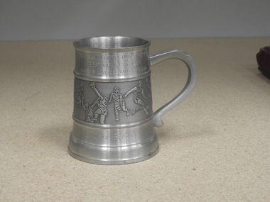
Pewter Mug, TOM ALVIN PERPETUAL TROPHY Presented Latrobe Valley Hyundai, 1997
Yarra Valley Hyundai presentation to Carlton B&F winner 1997A perpetual Trophy presented by a major sponsor Hyundai in the guise of "TOM ALVIN PERPETUAL TROPHY". In 1997 it was presented to Craig Bradley Carlton Best & Fairest winner 1997. Career : 1986 - 2002 Debut : Round 1, 1986 vs Hawthorn, aged 22 years, 159 days Carlton Player No. 931 Games : 375 Goals : 247 Last Game : Round 19, 2002 vs Port Adelaide, aged 38 years, 291 days Guernsey No. 21 Height : 182 cm (5 ft. 11 in.) Weight : 81 kg (12 stone, 11 lbs.) DOB : 23 October, 1963 Premiership Player 1987, 1995 Carlton Legend Carlton Hall of Fame (1995) Best and Fairest 1986, 1988, 1993 All Australian 1986, 1993, 1994, 1995, 1997 Captain 1998-2002 Team of the Century: Wing International Rules Series vs Ireland : 2000, 2001 (captain), 2002 Off the field, Craig Bradley was a somewhat quiet, unassuming character who never hungered for the spotlight. But when the umpire’s whistle blew for a game of Australian football, he became a consummate professional whose outstanding ball-winning ability, accurate disposal, punishing non-stop running and longevity in the game made him one of the all-time greats. “Braddles” captained the Blues for three years, won two AFL Premierships, and picked up almost every possible honour in a stellar career that spanned 17 seasons and a record 375 games for the Carlton Football Club. He began his football journey at Pooraka in outer-suburban Adelaide, where his father was coach of the Under-19 team. Craig was a stand-out junior footballer, and in 1981 he was recruited by SANFL club Port Adelaide. At the same time, Essendon also made a big pitch for his signature. The Bombers were very intent on getting him to Windy Hill, but Bradley wasn’t then ready to make the big move interstate. Essendon redoubled their efforts after Bradley’s sensational debut year for Port Adelaide, which culminated in the Magpies’ 51-point demolition of Glenelg in the Grand Final. Playing on a wing, but roaming the length of the ground, 17 year-old Bradley was one of his team’s best. He followed up by winning Port’s Best and Fairest in 1982, before departing for England later that year, as a member of the Australian Under-19 cricket team. Cricket was Braddles’ other great sporting passion, and he would eventually play two Sheffield Shield games each for South Australia and Victoria, before giving the game away to further his football ambitions. Because of his cricketing commitments, Bradley missed most of the 1983 pre-season with Port, but it made little difference, because he had another dominant season for the Magpies and was named All Australian for the first time. Two more Port Adelaide Best and Fairests followed in 1984 and '85 – with the latter complemented by All Australian honours again. In that year of 1985, four South Australians were named as All Australians; Bradley, Stephen Kernahan, Peter Motley and John Platten – and to the chagrin and envy of every other VFL club (especially Essendon) the first three all signed to play with Carlton. In the following year that trio of stars took to VFL football like they were born to it, and a time of bubbling confidence began for the Old Dark Navy Blues. Braddles wasted little time in announcing his arrival into the upper echelons of our national game by playing in the 1986 Grand Final in his debut season at Princes Park; the same year he won his first Carlton Best and Fairest award in a tie with Wayne Johnston. The Blues lost heavily to Hawthorn on Grand Final day, but twelve months later bounced back to snatch the 1987 flag from the Hawks in Bradley’s 47th senior match. By then, he was already a budding champion whose amazing stamina was too much for almost every opponent. He simply ran his taggers into the ground, and he was as effective in the last minutes of a game as he was at the start. He won two more Carlton Best and Fairest awards in 1988 and 1993, and by the end of his superb career had been an All Australian six times. Aged 32, he picked up his second Premiership winner’s medallion in 1995 when the unstoppable Kernahan-led Blues demolished Geelong in a one-sided Grand Final, but those who thought he might retire after that triumph were right off the mark. He still had his zip, his footy smarts and his brilliant foot skills, and he had transformed himself from a purely attacking weapon into an equally-effective sweeper across half-back. And to cap off a memorable season, he became one of only a handful of players to be inducted into the Carlton Hall of Fame while still playing out their career. In 1997, at the age of 34, Bradley won the Sunday Age Footballer of the Year award. ”It’s not the end of the world when you reach 30,” he said in a blunt response to those who kept asking how long he intended going on – to his considerable annoyance. After being named All Australian yet again that year, he answered all those sorts of questions when he was appointed captain of his beloved Blues in 1998 – after the retirement of his great mate ‘Sticks’ Kernahan. Braddles led the Blues into another Grand Final in 1999, but the Wayne Carey-inspired Kangaroos proved just too good. Further indication of Craig Bradley’s enduring ability was his record in the often controversial and passionately-contested International Rules Series against Ireland. He first played for his country in 1984, and was recalled again in 2000. He was appointed captain of Australia in 2001, and played a fourth round of matches in 2002 at the age of 38 – a truly amazing achievement. In the millennium year of 2000, the honours kept rolling in for Braddles when he was included in both Carlton and Port Adelaide’s Team of the Century. In turn this raised the usual debate over why he had never won the game’s most prestigious individual award, the Brownlow Medal. The answer was apparently found when former field umpire Peter Cameron was interviewed, and he revealed that during most games, Bradley regularly back-chatted the men with the whistle. “He’s in the umpire’s ear all the time,’ said Cameron. By circumstance, Braddles wore his iconic number 21 guernsey for the last time against Port Adelaide at Princes Park in round 19, 2002. Carlton lost the match by 9 points, and Bradley suffered broken ribs and a punctured lung in a heavy collision. Even so, he was an almost unanimous choice as Best on Ground and was given three Brownlow Medal votes by the umpires. A few weeks later, Bradley’s farewell was typical of his nature. There was no big press conference, no stage-managed extravaganza. Instead, he issued a written statement through the AFL that caught everyone – including the Carlton Football Club by complete surprise. It read (in part); I have many people to thank and will do so in the coming weeks. I would however like to thank the Carlton Football Club and the Port Adelaide Football Club for many wonderful times and for their influence in helping to shape my life. To leave the game with a bit left in the tank and in good personal form makes me feel good. Since the foundation of the VFL in 1897, only three men (Michael Tuck, Kevin Bartlett and Simon Madden) have played more senior games than Craig Edwin Bradley of Carlton. A true Blue champion, he is one of only ten official Carlton Legends, and in 2006 was Carlton’s 17th inductee into the AFL Hall of Fame. In October 2006, it was announced that Bradley would return to the club for season 2007 as an assistant to senior coach Brett Ratten – a role he filled with the same intensity as he showed on the field. Bradley holds the club record for most career disposals, kicks, handballs, & Brownlow votes with totals of 8776, 5876, 2900 & 144 respectively.Pewter MugTOM ALVIN PERPETUAL TROPHY Presented Latrobe Valley Hyundai Best & Donated 1997 Craig Bradley -
 Carlton Football Club
Black & White Photos x 2, John O'Connell
Two Pictures of 1972 Premiership Player John O'ConnellCareer : 1970 - 1976 Debut : Round 3, 1970 vs Richmond, aged 18 years, 361 days Carlton Player No. 818 Games : 111 Goals : 0 Guernsey Nos. 50 (1970-71) and No. 19 (1972-76) Last Game : Preliminary Final, 1976 vs North Melbourne, aged 25 years, 149 days Height : 183 cm (6 ft. 0 in.) Weight : 82 kg (12 stone, 13 lbs.) DOB : April 22, 1951 Premiership Player 1972 After starting his career at Carlton as a centreman or ruck-rover at Under-19 and Reserves level, John Michael “Jack” O’Connell found his niche in defence for the Blues and was a creative back pocket in Carlton’s record-breaking 1972 Grand Final victory over Richmond. A dasher who loved to take off on bouncing runs, Jack spent much of his career alongside champion full-back Geoff Southby, with either Vin Waite or David McKay in the opposite pocket. Together, they created a full-back line regarded as among the best in club history. O’Connell’s journey to Premiership glory began during his school days at St Mark’s in Melbourne’s outer north, then at Glenroy YCW and Fawkner. In 1967, aged 17, he joined Carlton’s Under-19s, and by midway through 1969 he was playing Reserves football in guernsey number 50. Early in the following year, a couple of strong showings saw him banging on the door of senior selection, and he was duly rewarded by being named on the bench for his senior debut against Richmond at the MCG in round 3, 1970. For the Blues and their supporters, the game was a forgettable one, because Carlton surrendered a big half-time lead to be beaten by 13 points, and O’Connell wasn’t called on until the dying minutes. Sent back to the Reserves after that one brief taste if the big time, Jack honed his skills and bided his time - for more than a year – while Carlton went on to win the 1970 Premiership. Eventually, he earned a recall midway through 1971, but with a bevy of stars standing in his way, he was a regular reserve until late in the year, when coach John Nicholls – aware that incumbent Ian Collins intended to retire – offered O’Connell a chance in the back pocket. Jack grasped his opportunity with both hands. At 183 cm and 82 kg he was bigger than the average specialist back-pocket of that era, but he gave nothing away in agility. An excellent mark and an accurate kick off either foot, he had settled in beside Southby by the end of that season, playing the last ten games straight. As season 1972 dawned and Collins retired, O'Connell inherited the Blues’ number 19 guernsey and began marking his mark in the Carlton defence. Inspired by Southby’s creativity and Waite’s aggression, Jack was soon a headache for every opposition club. An ankle injury sustained in round 5, 1972 against Collingwood cost him five matches, but he was back to top form by finals time, when Carlton finished the regular season on top of the ladder. In their first final together – the Second Semi Final - O’Connell, Southby and Waite were resolute in a thrilling draw. Richmond won the replay, then Carlton conquered St Kilda in the Preliminary Final to earn another crack at the Tigers in the Grand Final. Opting for a strategy of all-out attack in the flag decider, the Blues blasted off the blocks to kick 8 goals in the first quarter, 10 in the second and 7 in the third to put the game right out of Richmond’s grasp with a full quarter remaining. After coasting to the final siren, the Blues collected their eleventh VFL Premiership by 27 points. Waite was missing from the match, having been injured in the Preliminary Final, but David McKay was a more than adequate replacement, and all three defenders on the last line completed an excellent final series. On the way to another consistent season in 1973, O’Connell strained a thigh in Carlton’s surprise loss to Fitzroy at the Junction Oval in round 16, and wasn’t recalled to the senior side until the Grand Final, when Carlton and Richmond met once more in the 48th match of Jack’s career. A few days beforehand, Barry Armstrong had been ruled out when he was hit by appendicitis, so O’Connell took over Armstrong’s assigned role of negating the Tigers’ star centreman Ian Stewart. Jack stuck to his task all match, but neither he nor his team could hold back a ferocious Richmond side that crashed and bashed its way to victory. O’Connell went on to play in two more finals campaigns in 1975 and ’76 but was denied the joy of another September victory. He brought up game number 100 at Princes Park in June 1976, when Carlton ended a five-game losing sequence to beat Essendon, before calling time on his VFL career after the Blues suffered a heart-breaking 1-point loss to North Melbourne in that season’s Preliminary Final. In 1977 O'Connell was cleared to WAFL club Subiaco. Later he came back to Victoria and coached Diamond Creek to a Premiership in the Diamond Valley League. Then in 1987, the football world was rocked by the news that Jack had been diagnosed with a virulent form of cancer. He fought hard for 18 months, but tragically passed away on the 5th November, 1989 aged just 38. Career Highlights 1971 - 3rd Reserves Best & Fairest 1971 - Reserves Most Improved Player 1972 - Premiership Player Milestones 50 Games : Round 2, 1974 vs Geelong 100 Games :Round 13, 1976 vs Essendon Footnotes Off the field, O’Connell was a quiet, reserved character who, by 1973 had struck a warm friendship with another man of few words in his champion team-mate Bruce Doull. The pair could often be seen together sharing a beer after Sunday morning recovery sessions, and club folklore has it that the only regular conversation to be heard between them was, “it’s your shout.” In 1997, John's son Luke O'Connell joined Carlton, playing eight Reserves games and kicking three goals.2 x Black & White PhotosThe Sun Articles pasted on back of each photo -
 Melton City Libraries
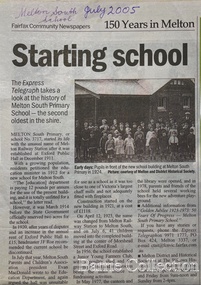
Newspaper, Melton Schools-150 years in Melton, 2005
Melton South "The establishment of a settlement of Melton South was induced by the opening of the railway in 1884. This subsequently prompted a number of industries, initially sawmills, and in the early twentieth century, chaff mills. This development coincided with the Exford ‘Closer Settlement’ estate at the beginning of the new century, boosting local population and produce, and the development of the chaff industry which employed many people in the Melton area. (Around 1912 the government had brought out English migrants to settle the Exford estate.) By c.1912 the small Melton Railway Station settlement had a boarding house (probably for chaff or sawmill employees), store, a small church and a hall. The Melton Valley Golf Club originated near the railway station in 1927 (in 1931 it moved to the present Melton links). In 1910 the community had built the large timber ‘Victoria Hall’, which became the focus of community life for several generations. In August of that same year AR Robertson MP and D McDonald applied for the establishment of a school on land set aside for that purpose by the Closer Settlement Board, near the Melton Railway Station settlement. District Inspector McRae recommended that a school for classes up to Grade 3 be established as an adjunct to the Melton State School. And so SS3717, ‘Melton Railway School’, was established in the leased Victoria Hall on 1st December 1911. Thomas Lang, head master at Melton since 1896, was in charge of both schools. As a ‘prep’ school only, it was necessary that the older Melton Railway Station settlement students travel to Melton SS430 at Unitt Street. Since 1912 local residents had been petitioning for the establishment of a separate school at Melton Railway Station on the grounds that it would be better if all children from the one home could attend the same school, and that the Victoria Hall was unsuitable as a school building. As a result an area of 2 acres - Allotment 8, Parish of Djerriwarrh, Exford Estate - was reserved for a State School on 4th March 1914. However the Department wrote that a school would not be established there in the near future, as ‘there is no likelihood in sight that the Railway Station settlement will increase in importance’. Parents persisted with their petitions to the Education Department, claiming that the Victoria Hall was too large, had no fireplace, that teachers were unable to use the wall for teaching aids, and that, being less than 20 metres away from a chaff mill employing 30 men, was too noisy. The turning point came when in 1920 the Hall Committee decided to increase its rent for the hall. In 1920 Head Teacher Lang advised the Education Department to discontinue SS3717 as an adjunct. The District Inspector supported this recommendation, and the schools separated in 1923. In April of that year 41 children, comprising Grades 1-8, moved into an almost completed brick building on the present site. On the 6th July 1923 the official opening of the school took place; after a ceremonial journey from the Hall to the school, speeches were given by the Hon AR Robertson and the Chief Inspector of Education. Everyone then journeyed back to Victoria Hall for a ‘bountiful repast’. (These dates are at odds with the date of 5th March 1925 given in Blake as the date the children occupied the new SS3717 brick school building. ) A teacher’s residence had been purchased for ₤500 in 1923, and the school’s name was changed to ‘Melton South’ in the same year. Even though the older Melton South pupils would no longer have to travel to the Unitt Street school, an additional brick room was still required at the Melton SS430 in that same year. In 1961 a new room was added to the school. In 1972, at the beginning of Melton’s boom as a satellite town, the number of enrolments was 224. The school has since shared in the exponential growth of the town of Melton, and at the time of its jubilee celebration (1983), 524 pupils were enrolled. Victoria Hall, neglected and vandalised, was demolished in 1992. It had been handed back to the Council on condition that it be replaced by a new hall, with the same name, and was commemorated by a plaque. Apart from the 1923 brick school building, and the railway station, none of the principal early Melton South public sites survive. Few early residential sites remain. (Further research will establish whether the house on the corner of Station Street and the railway line was the original teacher’s residence.)" Melton State School "On 17th May 1858 a State subsidised, combined Denominational School was opened by HT Stokes, with an attendance of about 30 children. This school was conducted in the wooden Melton Combined Protestant Church, situated on ‘a creek flat’ thought to be on the north side of Sherwin Street between Pyke and Byran Streets. It is likely that the Church had been established by 1855 and that the first minister was the Rev. Hampshire, who lived in Cambridge House on the Exford Estate. Ministers of the Protestant denominations were invited to hold services there. As there was only one resident Minister in the town (Presbyterian Mr J Lambie), laymen of the various denominations often spoke on Sundays. In 1863 this building was declared a Common School with the number 430. One of its first and most prominent headmasters was John Corr, who served from 1860 to 1864. Most of Mr Corr’s children also became teachers, including Joseph Corr, at the Rockbank school, and J Reford Corr and WS Corr, headmasters and teachers at numerous prestigious private secondary schools around Australia. John Corr purchased land alongside the school and elsewhere in and near Melton, became secretary and treasurer of the new Cemetery Trust, and by July 1861 was deputy registrar of births, deaths and marriages. He walked three miles every Sunday to teach at the Weslyan Sunday School he had established. Despite good reports from the Education Department Inspector, and burgeoning enrolments, the local school committee recommended the dismissal of, firstly, his wife (from the work mistress position), and then him from the headmaster position. Corr saw his dismissal as an attempt to redirect state aid for education from the Combined Protestant school to the support of the Free Presbyterian Minister Rev James Lambie (by one account the owner of the land on which the Common School was erected), whose son-in-law James Scott subsequently assumed responsibility for the school. Rev Lambie failed in his efforts to keep the existing school, which the Education Department Inspector and the majority of Melton citizens regarded as badly situated and badly built. Following a conditional promise of state aid, local contributors in 1868-69 raised ₤72.10.6 towards the cost of an iron-roofed bluestone rubble building 43 ft x 12 ft. This was erected on a new site of 1.5 acres (the present site). The State contributed ₤120 to the new school, which opened in 1870. A very early (c.1874) photograph of the school shows its headmaster and work mistress / assistant teacher (probably James Scott and his wife Jessie) and its (very young) scholars. Similar photos show pupils in front of the school in c.1903, and 1933. In 1877 a second bluestone room costing ₤297 was added and further land acquired from the Agricultural Society (who only needed it two days a year) to enlarge the schoolground to 3 acres. In the early 1880s an underground tank augmented the school water supply and in 1919 a five-roomed wooden residence was added. During this period the school correspondents often compained that the walls of the bluestone buildings were damp, affecting the plaster. In 1923 a brick room 26 ft 6 in by 24 ft with a fireplace and four rooms facing south, was added, and a corridor built to link the three buildings. This served adequately for the next 40 years. The school bell probably dates to 1883. The school also has a memorial gate (1951) to World War One ex-students, and an honour board to the 64 ex-students who served in the First World War. The school roll fell to 42 in the early post war-years, but was boosted by an influx of migrants, mainly from the UK, from the late 1960s. This presaged the boom in Melton’s development, and the corresponding growth of the school, with timber and temporary classrooms added to the previous masonry ones. An endowment pine plantation established in 1930 augmented the school’s fundraising activities when it was harvested in 1968. Part of the site was planted with eucalyptus trees in 1959. Famous ex-students of the early twentieth century included Hector Fraser (internationally successful shooter) and cyclist Sir Hubert Opperman". The Express Telegraph articles about the history of Melton South and Melton State Schoolseducation -
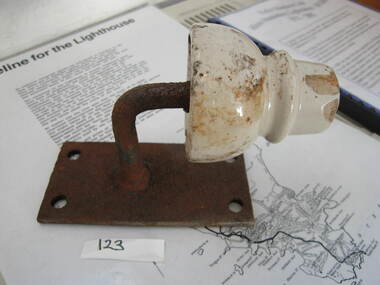
 Parks Victoria - Wilsons Promontory Lightstation
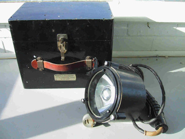
Lamp, Aldis
The lamps were pioneered by the British Navy in the late nineteenth century and introduced by the Royal Australian Navy after 1918, and continue to be used to the present day. Manufactured in 1960, the Wilsons Promontory lamp was provided to the lighthouse by the Department of Shipping for signalling ships but was also used for communicating with Cliffy Island, 18 nautical miles away. This type of lamp was renowned for its brilliant light, and lightkeepers from the two lightstations ‘used to practice their signalling with each other, as its effective use was reliant on precise positioning of the scope which is located on top of the lamp’. The inside of the case is imprinted with ‘RAN (Royal Australian Navy), and details on the lamp include a serial number, the date of 1960 and the initials of the Department of Transport, which at that time incorporated the Commonwealth Lighthouse Service. Another Aldis lamp and case with a date of 1960 is held at Cape Nelson and third lamp and case is at Point Hicks; (date unconfirmed but possibly 1943). A fourth lamp and case formerly at Cape Schanck disappeared from the collection sometime between 1995 and 2003.Aldis lamp and case (WPLS 0003.2; likely provenance) The lamps are not rare in museum collections however the Wilsons Promontory example has a confirmed provenance to the lightation and has first level contributory significance as a fine example of the Aldis lamps that were distributed to lightstations throughout Victoria and Australia.1. Handheld black signaling lantern with trigger mechanism. Glass front with inner reflective disc. Black electrical cord is attached with a two pronged plug at the end. 2. Black painted wooden box for transporting lantern. brass catch, leather handle. Grey electrical cord inside plus transformer. Hinged lid. The Aldis lamp is portable, hand held visual signalling lamp with trigger mechanism and inner reflective disk used for optical communication via Morse code. The concave mirror is tilted to focus the light into pulse signals. Larger versions of the lamp are fixed on ships or pedestals and have shutters in front of the device that are opened and closed to transmit signals. Wilsons Promontory’s black metal Aldis lamp and attached electrical cord has a black painted wooden carrying case with metal clasp and leather hand grip.1. On trigger;"AP16413" Around V shaped protrusion attached to lamp "AP197873 / AEI .LTD 59" Beneath screw on face;"AD16415" Inside lamp, under glass;"ADMIRALTY PATTERN 16409 / 5 INCH HAND SIGNALING LANTERN SERIAL No. 212 Year 1960 / AEI PTY LTD SYDNEY" •2. Box. On brass plate below handle."ADMIRALTY PATTERN 16409 / BOX FOR TRANSPORTING LANTERN / PATTERN 16409" Inside box on side of metal insert attached to inside of box;"EXTRA LOW VOLTAGE TRANSFORMER / MADE BY / M.Brodribb, Melbourne/ cat & APP / No v/QR / 1811A / 50 / 60 va / CONT. 55 c / RATIO 240, 12 V TAPS " Top of metal box on sticker;"C of A / D.O.T 143076 / 12 V 5A" On Bakelite plug on metal box;"EXTRA LOW VOLTAGE" -
 Parks Victoria - Wilsons Promontory Lightstation
Muslin & Wick
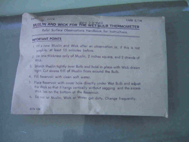
This item, which dates to 1988, is contained in the original supply packet and survives in good condition. It was commonly used by lightkeepers for both wet and dry bulb thermometers, with the muslin going into the bottom of the dry bulb where it was held in place by the wick and ‘end of the wick was then placed in a jar of deep water to keep the bulb cool’. The difference in temperatures between the dry and wet bulb thermometers could then be worked out to establish the dew point in the air.They were common in lightstations, but this intact item remains in the original packaging and is a fine representative example of its kind. It was acquired from the Bureau of Meteorology. Recording and communicating weather readings was an important facet of lightstation work and a number of different but related items of meteorological equipment survive at the six lightstations managed by parks Victoria. The Cape Nelson collection includes a pair of Australian-made thermometers in their original box, both in Fahrenheit, with one recording the minimum, the other the maximum temperature and a barometer table with instructions for correcting readings. Cape Otway has a Beaufort Scale, a table of wind forces which lists 12 types on a scale of 1 to 12, and provides associated speed in knots and travel time per minute or hour. Gabo Island has an anemometer, wind speed indicator and a wind speed recorder.Muslin and wick for a wet bulb thermomenter in unopened white paper packaging with directions for use printed on the package on the front.On front of package,"MUSLIN AND WICK FOR WET BULB THERMOMETER......." -
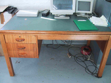 Parks Victoria - Wilsons Promontory Lightstation
Desk
This fairly substantial wooden desk with vinyl top was issued to Wilson’s Promontory Lightstation by the Department of Public Works in the 1960’s. Primarily the desk was used for correspondence purposes, and now has the Bureau of Meteorology computer stationed on it. Although the design and make of this desk is common to many lightstations across Victoria, it is a good example of the kind of furniture that was provided to Victorian lightstations in the 1960’s. The solidly constructed desk was used in the lightstation office. It is made of honeycoloured hardwood and has a green vinyl top and three drawers on the left side. The style suggests that it may date to the 1960s. Gabo Island Lightstation has two identical desks, and all were probably standard issue from the Commonwealth Lighthouse Service or Public Works Office. Another twentieth century vinyl topped desk at Gabo is manufactured with a steel frame. Cape Nelson, Cape Schanck, Point Hicks and Gabo Island retain nineteenth century cedar desks. The desk at Wilsons Promontory has second level significance as a good example of the style of office furnishing provided to lightstations in the 1960s.Wooden desk with square legs and green vinyl top. It has three drawers with wooden handles on the left . The top drawer has a keyhole. -
 Parks Victoria - Wilsons Promontory Lightstation
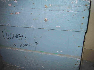
Box
The grey painted heavy wooden, homemade box has a freehand inscription in black on outside, which reads ‘LEVINGS To MAAT IS’. The writing refers to Alan and Marlene Levings, who began their twenty-two year career in lightkeeping with a posting to Tasman Island, off Port Arthur, in the 1960s. After four years they moved to Maatsukyer Island off south-west Tasmania, Australia’s southern-most lightstation, followed by postings to South Bruny, Eddystone Point and Wilsons Promontory. The robust box journeyed with the Levings through their postings to five lightstations and came to rest at Wilsons Promontory when Alan retired. It is not known whether the box was used in an office or domestic context. The movement of people and objects is a significant and unique theme that runs through the history of Australia’s lightstations. This historical process relates Victoria to the much bigger story of Australia’s network of lightstations. Alan Levings has been described as an extremely interesting character and artist. When Levings was a lightkeeper at Wilson’s Promontory, delivery of goods was by boat, then off the boat by a winch and onto the back of a truck. For this reason, packing boxes in earlier years had to be extremely robust. Today, anything that is not carried into Wilson’s Promontory Lightstation by foot, comes by helicopter, eradicating the need for heavy packing boxes such as Levings’. This humble box has first level contributory significance for its reliable provenance which traces its journey through five lightstations; for its association with a former lightkeeping family; and for contributing to an understanding of the pattern of lightstation life.Wooden box, light blue/grey painted. Made of horizontal pieces of timber with some tin reinforcment on the sides. Writing in black on side of box.On side of box in freehand,"LEVINGS To MAAT IS" -
 Parks Victoria - Wilsons Promontory Lightstation
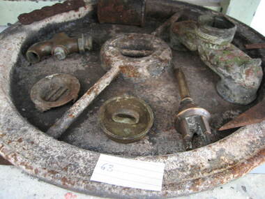
Tank lid
Lid for ship's tanks used for early domestic water storage (1860's) at the lightstation The water tank and lid are probably from the same unit that was used for transporting drinking water or perishable dry goods on ships. The unit comprised a large, riveted metal tank which was fitted with a heavy cast iron round lid to form a hermetically sealed container. It had a rubber sealing ring ‘which was screwed tight with the aid of lugs cast into the lid and wedges cast into the rim of the loading hole’. A raised iron rod welded across the outer face of many lids allowed for screwing the lid tight. Ship tanks were invented in1808 by notable engineer, Richard Trevithick and his associate John Dickinson. Their patent obtained the same year described the tank’s superior cubic shape that allowed it to fit squarely as a container in ships and thus use space efficiently, while its metal fabric preserved and secured its contents, whether liquid or solid, from damage. The containers revolutionised the movement of goods by ship and made wooden casks redundant. Research by Michael Pearson has determined that they were carried on passages to Australia from at least the 1830s, conveying ships’ victuals and water storage as well as general goods heading for the colonies, and by the 1870s they were in common use. Once in the colonies, the tanks were often recycled and adapted for many resourceful uses such as water tanks, packing cases, dog kennels, oil containers and food stores and this invariably led to the separation of the lid and tank. Raised lettering on the lids indicates that nearly all of the ship tanks transported to Australia came from London manufacturers, and it was usual also for the brand name to feature as a stencil on the associated square tank but in most cases this eventually wore off. It is not known if the Wilsons Promontory tank retains its stencil, and the heavy lid will need to be turned over to reveal its manufacturer’s name. How it came to the lightstation is also not known, but it was either brought to the site as a recycled tank or salvaged from a shipwreck. Pearson writes that Ship tanks show up at a wide range of sites, many of them isolated like lighthouses. They were, I think, usually taken there for the purposes they filled, usually water storage, as they were readily available, relatively light to transport, and probably very cheap to buy as second‐hand goods containers. In rural areas they may have been scavenged for their new uses from local stores, to whom goods were delivered in them. Recycled to serve as a water tank, the Wilsons Promontory tank is the last surviving example of several that were used at the site to hold water for domestic consumption. The tank has had its lid removed and a tap fitted to the one of the sides. It stands on concrete blocks next to a building to receive water running off the roof via a metal pipe. Wilsons Promontory is the only lightstation managed by Parks Victoria with a tank container, although Cape Otway and Point Hicks have lids. Parks Victoria has identified four other lids which include two at Point Hicks, one manufactured by Lancaster and Co. the other by Bellamy. Cape Otway also has two, one unidentified and the other by the Bow Tank Works, East London, which produced tanks between 1910 and 1930. Pearson notes that ‘surviving lids are far less numerous than the tanks themselves, presumably because the uses to which the tanks were put did not require the lid to be retained’. The tank and lid, which are possibly part of the same unit, have first level contributory significance for their historic values and rarity. Round ship's tanks lid, iron. -
 Parks Victoria - Wilsons Promontory Lightstation
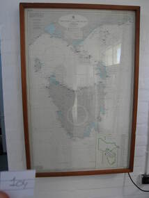
Nautical chart
Used as display in AMSA workshop foyer, Moorabbin, Vic. Nautical charts x 2 , The framed and glazed chart identifies strategic points in the notorious Bass Strait passage, which in the nineteenth century was known as the ‘Eye of the Needle’. It covers the whole of Tasmania, Bass Strait and the islands, and the lower part of Victoria with its coastline between Cape Otway and Gabo Island. The chart has an electric cord connecting it to a wall switch which enables a series of small lights to flash on strategic geographical locations.. While it is not known if it is original to Wilsons Promontory, it certainly elates to its location. A similar chart at Cape Otway shows less of Tasmania and is not electrified. Gabo Island Lightstation has two large framed charts; one is the same as the Wilsons Promontory example but without the lights and the other is entirely different, focussing on the east coast between Point Hicks and Montague Island. The Wilsons Promontory chart is unique as an illuminated version of the other charts and has first level significance if its provenance to the lightstation can be confirmed.The framed and glazed chart has an electric cord connecting it to a wall switch which enables a series of small lights to flash on strategic geographical locations.Yes -
 Parks Victoria - Wilsons Promontory Lightstation
insulator & metal support
The ceramic insulators were used by the PMG to insulate telephone lines connecting to the lightstation accommodation. The installation of a single galvanised wire telegraph line in 1873 provided the lightstation with a vital link to the outside world via Morse code. In 1875, the Australasian Sketcher reported on the new facility, writing that ‘the lighthouse on the extreme point of the promontory is connected with Melbourne by a line of telegraph, and as a large number of vessels pass in sight of the lighthouse, useful information is gained respecting their movements’.The system was immobilised in 1885 when a thunderstorm caused some of the poles to explode and connection wires to fuse and turn into molten metal. During WWII the lighthouse line was upgraded to four copper wires, and in 1971 a radio link replaced the line. The lines required constant maintenance. Some poles remain along the length of the promontory’s Telegraph Track as reminders of this former communication link. Insulators can also be found in the collections at Cape Schanck; Cape Otway and Gabo Island. Comprises a white ceramic insulator attached to a rectangular metal plate. -
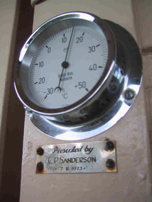 Parks Victoria - Mount Buffalo Chalet
Gauge, temperature
Appears to be original to Mt Buffalo Chalet. "A number of specific items, which have been useful in the day to day operations of the Chalet, remain in the building with each complementing the other to provide context, meaning and character to their setting. Items such as the hall porter bell, the many signs providing information to the guests, the wall clock, barometer and dinner bell point to the Chalet being a well-run social institution with a pleasant environment for rest, recreation and congenial company." (Pg 81 Historica, MBCC) This temperature gauge has a plaques inscribed "Presented by C.P Sanderson 7/08/1973. It is not known who this person was. Listed in Draft Inventory of significant Collection items. A.3 Fixtures and fittings. (Pg165 Historica Cultural Heritage Projects. Mount Buffalo Chalet collection. Prepared for Parks Victoria, 2011)Listed in Draft Inventory of Significant Collection ItemsSmall circular silver coloured temperature gauge mounted to wall. Plaque attached below temperature gauge. Face is white and has a glass cover.Plaque below barometer: "Presented by C P Sanderson / 7 - 8- 1973" -
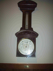 Parks Victoria - Mount Buffalo Chalet
Barometer
"A number of specific items, which have been useful in the day to day operations of the Chalet, remain in the building with each complementing the other to provide context, meaning and character to their setting. Items such as the hall porter bell, the many signs providing information to the guests, the wall clock, barometer and dinner bell point to the Chalet being a well-run social institution with a pleasant environment for rest, recreation and congenial company." (Pg 81 Historica, MBCC) "The barometer mounted on an ornately carved backing was presented by flour miller John Spencer Brunton (1861-1937), son of Thomas Brunton who founded the Brunton & Co. flourmills. John had responsibility for the New South Wales arm of the company and lived in Sydney.' (Pg 82 Historica MBCC) " Fig 80. It was presented by John Spencer Brunton on 9 December 1930."(Pg83, Historica. MBCC) Listed in Draft Inventory of Significant Collection items A.3.. Fixtures and Fittings (Pg 165.Historica, MBCC)Barometer and thermometer with carved decorative leaf pattern wooden surround.On plaque below barometer:"PRESENTED BY / JOHN SPENCER BRUNTON / 9.12.30" (further inscriptions on face) -
 Parks Victoria - Mount Buffalo Chalet
Signs
Original directional signs from Chalet interior. Dated to pre 1960's. "A number of specific items, which have been useful in the day to day operations of the Chalet, remain in the building with each complementing the other to provide context, meaning and character to their setting. Items such as the hall porter bell, the many signs providing information to the guests, the wall clock, barometer and dinner bell point to the Chalet being a well-run social institution with a pleasant environment for rest, recreation and congenial company." (Pg 81 Historica, MBCC) Listed in Draft Inventory of Significant Collection Items. Appendix A.3 Fixtures and Fittings. (Pg 165 Historica MBCC) Varnished wooden directional signs with painted gold lettering to direct guests through the chalet to the cafe and the guests drying room. Signs have rounded edges and are attached to a vertical post.1. "Cafe, fruit, drinks, souvenirs, confectionary, tabacco, photographs, suppers etc." 2. "GUESTS DRYING ROOM"