Showing 11618 items matching " maps"
-
 Bacchus Marsh & District Historical Society
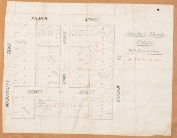
Map, Bacchus Marsh Estate sold 30th June 1888 and sold 28 December 1895
Blocks of land in this area of Bacchus Marsh were sold in lots between 1888 and the late 1890s. This map shows sales made in 1888 and 1895.Single page map showing allotments of land bounded by Pilmer Street, Graham Street, Sydney Street and Maddingley Road (Grant Street) in Bacchus Marsh.The area is dissected by Como Street down the central area. 43 blocks of land are shown with the names of buyers or sellers in 1888 written in black in. Buyers or sellers for December 1895 are written in red ink. Part of a set of maps which are pasted into a bound volume containing 76 maps or plans in total. High resolution digital image stored on BMDHS computer network. bacchus marsh victoria maps, land sales bacchus marsh, pilmer street bacchus marsh, graham street bacchus marsh, sydney street bacchus marsh, como street bacchus marsh, maddingley road bacchus marsh, grant street bacchus marsh -
 Whitehorse Historical Society Inc.
Document, Fromelles, 2012
Transcription of talk on the Battle of Fromelles.Transcription of talk on the Battle of Fromelles by Lambos Englezos to Whitehorse Historical Society 14 April 2012. With map of battle area. Tape at NP 3908Transcription of talk on the Battle of Fromelles.world war 1914-1918, fromelles -
 Orbost & District Historical Society
map/brochure, Discovering Marlo & The Snowy River Estuary, December 1988
In 1983 the Department of Conservation, Forests and Lands replaced the Department of Crown Lands and Survey, the Department of State Forests and the Ministry for Conservation. This brochure/map was used as tourist information in Orbost.This item is a useful research tool.A folded map/brochure titled "DISCOVERING MARLO & THE SNOWY RIVER ESTUARY". On the front is a photograph of Marlo and the title in yellow print. There is a locality map for access to Corringle beach and the brochure Includes a key to fishing sites and various tourist locations. On the back of the brochure are notes on fishing, wildlife and a boating guide, map brochure snowy-river marlo -
 Melbourne Tram Museum
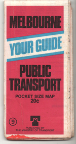
Ephemera - Map, Ministry of Transport, "Melbourne Your Guide PUblic Transport Pocket size map", 1979
Provided a detailed map of Melbourne's public transport, route number list and brief description. Has contact details for bookings and lost property etc. Priced 20c, published 1979 as map No. 9Demonstrates the methodology of providing map and transport information at the time.Fold out map (27 sections 9 across x 3 deep), coloured of Melbourne's Tram and Bus routes, route numbers, rail lines, detailed for the central part of Melbourne and insert section for Frankston. melbourne, map, tram and bus services, railways, mmtb, ministry of transport -
 Bendigo Military Museum
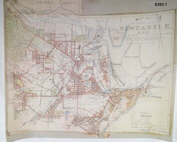
Map - Map of Newcastle NSW 4 Inch - 1 Mile 1910, Australian Intelligence Corps, Nov 1910
In 1909 the Australian Army Headquarters realized that mapping in Australia was either non existent or inadequate for Military use. It was requested that Australia borrow Survey personnel from the UK Royal Engineers (RE) for a two-year detachment. On 11 April 1910 four RE NCOs arrived in Melbourne comprising CPL J Lynch, and LCPLs AH Barrett, EF Davies and R Wilcox. LCPL Barrett had 12yrs experience with RE. They were aiming at producing eight map sheets per year covering about 7,000 square miles (18,000 square Km) This map sheet of the Newcastle area was produced using plane table methods and was surveyed and hand drawn by LCPL A Barrett Oct - Nov 2010. It was unique because it was now produced on an accurate gridded base and included contouring. Lynch and Davies transferred to the Royal Australian Engineers (RAE) whilst Barrett and Wilcox returned to the UK in June 1913. Barrett returned to Australia in 1915 and also enlisted in the RAE and served until 1919.A gridded Map of Newcastle NSW area scale four inches to one mile with 25 feet interval contouring. Coloured hand drawn map produced in 1910. Signed by " A Barrett LCPL Royal Engineers"royal australian survey corps, rasvy, fortuna, army svy regt, army survey regiment -
 City of Kingston
Pamphlet - Colour, H. R. Hill & Co, Walker's Estate, Cheltenham for sale by public auction, c. 1923
Sales plan for land in the suburb of Cheltenham, encompassing both sides of Walker Grove, a section of Centre Dandenong Rd and Axelton St. The developing urban area of Cheltenham within the City of Kingston. This land sale pamphlet illustrates the subdivision of land within the municipality and the changing demographic of the district as new houses are constructed.Black and white pamphlet advertising for private sale the Station Entrance Estate, Highett. Incorporates a map of the estate bordered by Wickham Road, Railway Parade, Highett Road and Point Nepean Road.Handwritten in black pen on subdivision map: 'x' written on subdivisions 2, 3, 8-11, 15-17, 19. Potentially indicating that these properties did not sell at auction. Handwritten in black pen on subdivision map: assumed sale price on subdivisions 1, 4-7, 12-14, 18, 20-31. land sales, cheltenham, estate -
 Glen Eira City Council History and Heritage Collection
Event Run-sheet and Map, "Booran Reserve Official Opening"
This run-sheet and map were used for the opening of Booran Reserve at the corner of Booran and Glenhuntly Roads on Tuesday 11 April 2017. The Reserve was officially opened by the Mayor, Cr. Mary Delahunty and The Hon. Philip Dalidakis, MP, Minister for Innovation. The run-sheet contains information about the Order of Proceedings of the opening ceremony. The map notes the locations of reserved parking, the route taken by Mayor Mary Delahunty and Minister Philip Dalidakis through the Reserve, and the speech and smoking ceremony site. The site of the Reserve was previously the Caulfield Service Reservoir.Black and white printed run-sheet, and green, teal, red, yellow, blue and khaki colour printed map -
 Ballarat Tramway Museum
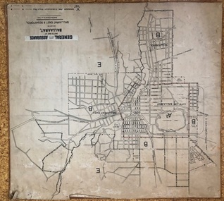
Map, General Accident Fire and Life Assurance, "Sketch Map of Ballaarat including Ballaarat East and Sebastopol", c1940
... Maps ...Yields information about Ballarat c1940 and how the area was rate for insurance purposes.Map - paper mounted onto a heavy card backing titled "Sketch Map of Ballaarat including Ballaarat East and Sebastopol" with a printed label "General Accident Fire and Life Assurance" pasted to the top of the title. Drawn at 30chains to the inch. Map shows the boundaries between the carious insurance classifications in the district, which relates partly to the local government areas at the time. Shows the Yarrowee, Gong Gong Creeks, rail lines, stations, Black Hill and some other features. Includes the Explosives factory area. Does not show the tram lines.trams, tramways, ballarat, maps, insurance, sebastopol -
Tatura Irrigation & Wartime Camps Museum
Folder - survey maps
Maps of no 14 A, B, C and D internment camps and documents on Loveday Camp, South Australia. Donated by Gerhard Meinke concerning Loveday Camp. Brief outline of camps life, release and repatriation, list of deaths, of POW's and internees.Blue back clear plastic folder containing maps of No 14 camp and documents on Loveday Camp.gerhard meinke, loveday camp, camp 14, south australian internment camps, japanese internees -
Hume City Civic Collection
Print - Street Directory, Gregory"s Melbourne Street Directory, c1972
... Maps ...This street directory was published by Gregory's Guides & Maps Pty Ltd of 142 Clarence Street, Sydney NSW in c1972. It was used by the donor's family for many years to navigate their way around Melbourne and the metropolitan area. A street directory enclosed in a black leather detachable cover with gold embossing of a car on the front cover.Gold embossed vintage car on front of detachable cover.joan houston, streets, roads, maps, street directory -
 Melbourne Tram Museum
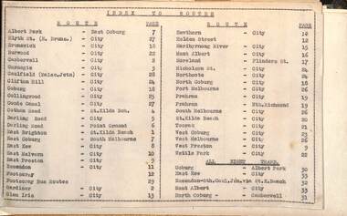
Administrative record - Tram fare route diagrams or maps, Melbourne & Metropolitan Tramways Board (MMTB), 1930s
... maps ...The route maps give for each tram, including cable trams, and bus routes, a map of the fare structure, sections, all-night routes, details of transfers and tickets such as combined tickets. Not dated as such but sheet 1 has a note regarding the East Brighton - St Kilda route that it was out of date from 16/10/1938.Yields information about the MMTB fare structure for tram, and bus routes during the 1930s.Album brown card heavy card coves, secured with two interscrews containing a type index, 33 cartridge paper sheets with ink drawings and six loose sheets. Hand drawn in black, red and green ink.mmtb, tramways, fares, maps, routes, buses, cable trams -
 Warrnambool and District Historical Society Inc.
Map - An Angler's map of the Hopkins River Estuary, Angler's map Hopkins River, 1980s
This is a map of the Hopkins River Estuary prepared by Dr John Sherwood for the benefit of anglers. The information on the sheet includes the location of sand banks, the water depths, boat ramp facilities and public access facilities. Some of the information has been gathered from aerial photographs. The map has been produced by the Warrnambool Institute of Advanced Education which was developed in the late 1960s from the tertiary section of the Warrnambool Technical College and with all its departments established by 1984 at the Sherwood Campus five kilometres from Warrnambool on the Princes Highway. Today the site is occupied by Deakin University, Warrnambool campus. The Warrnambool Anglers’ Club has its headquarters on the banks of the Hopkins River near the mouth of the river and the Lyndoch Aged Care facility.This map is of interest as a specialist one, providing fishermen with detailed information on all aspects of the Hopkins river estuary. Fishing has been both a profession and a popular recreational pursuit for Warrnambool residents since the early days of the city’s settlement. The Hopkins River Estuary has been a focal point for fishermen throughout Warrnambool’s history. This is a sheet of paper folded three times to produce a folded map. The front cover has a black and white photograph of two fishermen with a large fish. The map of the Hopkins River Estuary is in yellow, blue and black and covers the side of one sheet and three quarters of the other side. There is an advertisement for the Hopkins River Boathouse with a black and white sketch of the boathouse and notes on the map written by Dr John Sherwood. There are several diagrams showing the water depths. The map has some silverfish damage and some tearing at the folds. warrnambool anglers’ club, history of warrnambool, hopkins river, hopkins river estuary, john sherwood -
 Bendigo Military Museum
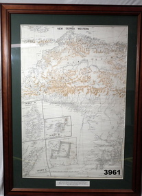
Map - MAP, NEW GUINEA FRAMED, 1941 onwards
Map of Western section of New Guinea. Black print on white background with mountain ridges in tan. Mounted with green border & brown wooden frame, glass front & white cardboard backing with wire hanging strap on back. Inset LHS bottom: A: Aroe Island B: KIA Island C: Taniimba IslandPrinted in black at top centre: “NEW GUINEA WESTERN’ Printed on border under map: “These escape maps were carried in the zip pockets of life jackets by fighter pilots in WW2. This map was presented to A.S.R. on the 12/7/79 by Councillor Ian McKenzie, Mayor of Eaglehawk, who served as a fighter pilot in 78th SQN in S.W. Pacific area during 1943-44.”map, new guinea, western, raaf -
 Federation University Historical Collection
Map, Ballaarat Gold Field, 1861, 21/10/1861
A party of surveyors camped by Yuille's Swamp (later Lake Wendouree) and surveyed the countryside for a map to be produced by the Geological Survey of Victoria. In November 2004 the Central Highlands Regional Library presented a special edition of 200 copies of the 1861 map reproduced from a copy in their collection. Original geological map of Ballarat showing property, waterways, mines, churches, schools, water races, and garden reserves. It was compiled and drawn from the surveys of Mining Surveyors Davidson, Fitzpatrick and Cowan.Compiled & Drawn from the Survey of Mining Surveyors Davidson, Fitzpatrick and Cowan & the Plans in the Surveyor General's Office by J. Brahe, 21st October 1861. R. Brough Smyth, Secretary for Mines. The Honourable J.B. Humffray, M.L.A. Commr of Mines.ballarat, map, davidson, robert brough-smyth, fitzpatrick, cowan, yuille's swamp, public garden reserve, manure depot, black hill, ballarat east, old post office hill, pennyweight hill, claytons hill, golden point, mining, railway, cricket ground, swamp creek, cemetery, sludge reserve, bakery hill, gaelic church, juvenile reformatory, orphanage, specimen hill, eureka lead, cattle yard hill, dalton's flat, chinese village, poverty hill, railway reserve, little bendigo diggings, pound reserve, allied armies, flour mill, agricultural reserve, marsh, survey reserve, survey corps, white flat, yarrowee, yarrowee creek, brache, j. brache, survey, ballaarat gold field 1861 -
 Victorian Aboriginal Corporation for Languages
Book, Bunj Consultants, Snapshots of Aboriginal Fitzroy, 2004
Features artwork by VACL Project Officer Mandy Nicholson.maps, photographswurundjeri, carlton gardens, alexandria gardens, maysar, batman treaty, oral histories -
Victorian Aboriginal Corporation for Languages
Conference proceedings, Marleen Haboud, Endangered languages : voices and images, 2011
Linguistic and Sociolinguistic properties; sociolinguistics and endangered languages; Rights, identities and new technologies; New media cultures and endangered languages; Rebuilding peoples in Ecuador and revitalizing their languages Documentation - successful experience; Language rights of endangered languagesMaps, graphslanguage endangerment, worrorra, language technologies, documentation -
 Victorian Aboriginal Corporation for Languages
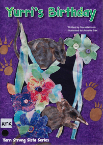
Book, Sue Atkinson, Yurri's birthday, 2013
Tonight would be a very special night for Yurri, it is her birthday. At midnight each of Yurri's friends arrive with a basket. Inside each basket is a gift for Yurri. Each illustrated basket has been made by women who live in Victoria and are passionate about the revival of basket coiling! Yurri's Birthday written by Sue Atkinson (Yorta Yorta) and illustrated by Annette Sax (Taungurung). This is the third book in the YSS series, giving young children insight into Indigenous Victorian culture. The Yarn Strong Sista series is supported by background notes and ideas for related activities.Illustrations, mapsyorta yorta, barmah forest, basket weaving, educational activities, language list -
 Victorian Aboriginal Corporation for Languages
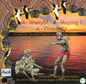
Book, Palibu Patrick Nudjulu, A-wanybi, A-muying i A-vilimindji = the mud crab, the magpie goose and the pied cormorant: ancestral knowledge of the Magati Ke Rak Naninh people, 2006
Story in Language and English with illustrationsillustrations, mapsmagati ke rak naninh people, storytelling, animals -
 Victorian Aboriginal Corporation for Languages
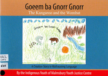
Book, Indigenous Youth of Malmsbury Youth Justice Centre, Goeem ba Gnorr Gnorr : the Kangaroo and the Wombat : a Creation story in Wathaurong Language, 2009
Creation story with word listmaps, illustrationswathaurong, yorta yorta, storytelling, word list -
 Victorian Aboriginal Corporation for Languages
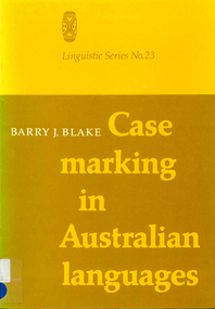
Book, Barry J Blake, Case marking in Australian languages, 1977
Linguistic study using case markings. Glossary.Maps, tableslinguistics, case relations in languages, pama-nyungan languages -
 Victorian Aboriginal Corporation for Languages
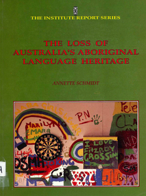
Book, Annette Schmidt, The loss of Australia?s Aboriginal Language heritage, 1993
Overviews Aboriginal language situation; examines attitudes to language; analyses language maintenance and revival programs, bilingual education, effectiveness of funding and National Aboriginal Languages Program; availability of linguistic training, characteristics of language loss and the place of creoles in language programs.Maps, chartslanguage loss, language maintenance, reports -
 Victorian Aboriginal Corporation for Languages
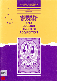
Book, Julie Bishop, Aboriginal students and English language acquisition, 1993
Assisting educators in South Australia to respond to specific language and literacy needs and goals of Aboriginal students.maps, tablesnepabunna, raukkan, coober pedy, education, resource-based learning, literacy, carlton primary school, english language acquisition -
 Victorian Aboriginal Corporation for Languages
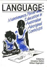
Book, Christine Walton, Language : maintenance, power and education in Australian Aboriginal contexts, 1990
Conference themes of language and power, language maintenance and language in education raised in an Aboriginal context; papers separately annotated.maps, tablesyolngu, yirrkala school, language maintenance, bilingualism, vernacular language -
 Victorian Aboriginal Corporation for Languages
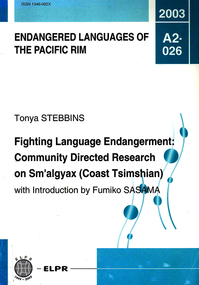
Book, Tonya Stebbins, Fighting language endangerment : community directed research on Sm'algyax (Coast Tsimshian), 2003
Based on studies of the language of the Tsimshian people, who live on the northwest coast of British Colombia, Canada. It describes the peocess of community directed documentation for an endangered language based on the dictionary project.Maps, tableslanguage endangerment, tsimshian -
 Victorian Aboriginal Corporation for Languages
Book, Aboriginal and Torres Strait Islander Commission Broadcasting, Languages, Arts and Culture Section, Needs survey of community languages 1996, 1996
The survey aims to document the Indigenous language situation and to establish the extent of Indigenous language needs so as to provide a sound basis for further program planning.maps, surveyeducation policy, language policy -
 Victorian Aboriginal Corporation for Languages
Book, Implementation Review Team on behalf of the Victorian Aboriginal Justice Forum, Victorian implementation review of the recommendations from the Royal Commission into Aboriginal Deaths in Custody : review report, 2005
maps, tablesaboriginal deaths in custody, criminal justice system -
 Victorian Aboriginal Corporation for Languages
Book, Board of Studies NSW, Aboriginal languages : advice on programming and assessment for stages 4 and 5, 2003
Includes Advice on Planning and Assessment, Samples on each stage, Sample Units of Work, useful Resources.maps, tableseducation, curriculum development -
 Victorian Aboriginal Corporation for Languages
Book, Victorian Curriculum and Assessment Authority, Aboriginal languages, cultures and reclamation in Victorian schools : standards P-10 and protocols, 2009
maps, diagramseducation, language revival, bilingual education -
 Victorian Aboriginal Corporation for Languages
Book, Australian Indigenous Languages Framework Project, Australian Indigenous languages framework support materials, 1994
maps, tableskaurna, education, bilingual education, lote, languages other than english, language revival, aboriginal english, language ecology -
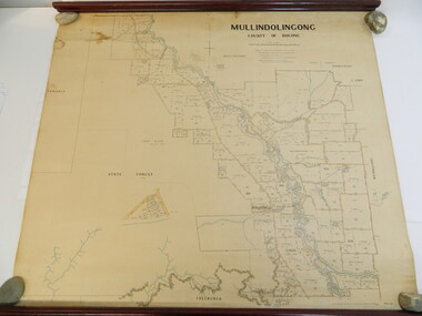 Kiewa Valley Historical Society
Map - Kiewa Valley, Parish Map of Mullindolingong, 12/10/1906
The map shows the names of people living in the parish of Mullindolingong in 1906. These people had leases or licences giving the reader an insight into the number of people in the area and an understanding of the size of their holdings. Infrastructure is also given including shops, schools, churches etc. Presumably it was used by the Ryder family.This map gives an historical insight into the parish of Mullindolingong as it names people and the infrastructure - roads, buildings etc. as it was in 1906. This enables the reader to compare the area at the time with other times and other places and to have an understanding of the early settlers in the area.This is a very old paper or parchment map with wooden rods top and bottom. The top rod has ribbons attached to enable hanging. The map shows the current leases and licences and when they were held by during this period, circa 1906.Mullindolingong County of Bogong. This plan has been prepared by The Most Reliable Data in the Possession of the Department up to the date of its Compilation. Information respecting Leases or Licences which await Final Completion is not recorded.parish of mullindolingong map; ryder family; early settlers;