Showing 1230 items
matching information board
-
 Kew Historical Society Inc
Plan, Melbourne & Metropolitan Board of Works : Borough of Kew : Detail Plan No.1571, 1904
The Melbourne and Metropolitan Board of Works (MMBW) plans were produced from the 1890s to the 1950s. They were crucial to the design and development of Melbourne's sewerage and drainage system. The plans, at a scale of 40 feet to 1 inch (1:480), provide a detailed historical record of Melbourne streetscapes and environmental features. Each plan covers one or two street blocks (roughly six streets), showing details of buildings, including garden layouts and ownership boundaries, and features such as laneways, drains, bridges, parks, municipal boundaries and other prominent landmarks as they existed at the time each plan was produced. (Source: State Library of Victoria)This plan forms part of a large group of MMBW plans and maps that was donated to the Society by the Mr Poulter, City Engineer of the City of Kew in 1989. Within this collection, thirty-five hand-coloured plans, backed with linen, are of statewide significance as they include annotations that provide details of construction materials used in buildings in the first decade of the 20th century as well as additional information about land ownership and usage. The copies in the Public Record Office Victoria and the State Library of Victoria are monochrome versions which do not denote building materials so that the maps in this collection are invaluable and unique tools for researchers and heritage consultants. A number of the plans are not held in the collection of the State Library of Victoria so they have the additional attribute of rarity.Original survey plan, issued by the MMBW to a contractor with responsibility for constructing sewers in the area identified on the plan within the Borough of Kew. The plan was at some stage hand-coloured, possibly by the contractor, but more likely by officers working in the Engineering Department of the Borough and later Town, then City of Kew. The hand-coloured sections of buildings on the plan were used to denote masonry or brick constructions (pink), weatherboard constructions (yellow), and public buildings (grey). This plan is the other half of Plan No.1571 representing the constructions to the west of Wellington Street before and in 1903/4. This plan represents the built environment in Edgevale Road, Wellington Street, Atkins Street, Annadale Street, Mortimer Street, and Cotham Road. Whereas there are smaller allotments and more modest housing stock facing Edgevale Road, larger blocks and more substantial houses are represented facing Cotham Road.melbourne and metropolitan board of works, detail plans, mmbw 1571, cartography -
 Kew Historical Society Inc
Plan, Melbourne & Metropolitan Board of Works : Borough of Kew : Detail Plan No.1572, 1905
The Melbourne and Metropolitan Board of Works (MMBW) plans were produced from the 1890s to the 1950s. They were crucial to the design and development of Melbourne's sewerage and drainage system. The plans, at a scale of 40 feet to 1 inch (1:480), provide a detailed historical record of Melbourne streetscapes and environmental features. Each plan covers one or two street blocks (roughly six streets), showing details of buildings, including garden layouts and ownership boundaries, and features such as laneways, drains, bridges, parks, municipal boundaries and other prominent landmarks as they existed at the time each plan was produced. (Source: State Library of Victoria)This plan forms part of a large group of MMBW plans and maps that was donated to the Society by the Mr Poulter, City Engineer of the City of Kew in 1989. Within this collection, thirty-five hand-coloured plans, backed with linen, are of statewide significance as they include annotations that provide details of construction materials used in buildings in the first decade of the 20th century as well as additional information about land ownership and usage. The copies in the Public Record Office Victoria and the State Library of Victoria are monochrome versions which do not denote building materials so that the maps in this collection are invaluable and unique tools for researchers and heritage consultants. A number of the plans are not held in the collection of the State Library of Victoria so they have the additional attribute of rarity.Original survey plan, issued by the MMBW to a contractor with responsibility for constructing sewers in the area identified on the plan within the Borough of Kew. The plan was at some stage hand-coloured, possibly by the contractor, but more likely by officers working in the Engineering Department of the Borough and later Town, then City of Kew. The hand-coloured sections of buildings on the plan were used to denote masonry or brick constructions (pink), weatherboard constructions (yellow), and public buildings (grey). Plan No. 1572 represents the built environment bordered by Barkers Road, Wrixon Street, Edgevale Road and Fitzwilliam Street. Other streets identified on the plan include Stansell Street. Plan 1572 shows that by 1903-05, there was only patchy development in this area of Kew, mainly on Edgevale Road and Fitzwilliam Street. Only two named houses are identified: the quaintly named ‘Tweed Cottage’, and ‘Mendip’. The earliest reference to Treed Cottage in Australian newspapers is to the death of Walter Thompson, aged 74 who was a resident there in 1885. His youngest daughter was to die there in 1908. Mendip to the north of Tweed Cottage was owned by Henry Thompson; he was to die in 1901; his wife in 1932. At this period of time, Malin Street and Clivedon Court did not extend to Barkers Road.melbourne and metropolitan board of works, detail plans, mmbw 1572, cartography -
 Kew Historical Society Inc
Plan, Melbourne & Metropolitan Board of Works : Borough of Kew : Detail Plan No.1573, 1905
The Melbourne and Metropolitan Board of Works (MMBW) plans were produced from the 1890s to the 1950s. They were crucial to the design and development of Melbourne's sewerage and drainage system. The plans, at a scale of 40 feet to 1 inch (1:480), provide a detailed historical record of Melbourne streetscapes and environmental features. Each plan covers one or two street blocks (roughly six streets), showing details of buildings, including garden layouts and ownership boundaries, and features such as laneways, drains, bridges, parks, municipal boundaries and other prominent landmarks as they existed at the time each plan was produced. (Source: State Library of Victoria)This plan forms part of a large group of MMBW plans and maps that was donated to the Society by the Mr Poulter, City Engineer of the City of Kew in 1989. Within this collection, thirty-five hand-coloured plans, backed with linen, are of statewide significance as they include annotations that provide details of construction materials used in buildings in the first decade of the 20th century as well as additional information about land ownership and usage. The copies in the Public Record Office Victoria and the State Library of Victoria are monochrome versions which do not denote building materials so that the maps in this collection are invaluable and unique tools for researchers and heritage consultants. A number of the plans are not held in the collection of the State Library of Victoria so they have the additional attribute of rarity.Original survey plan, issued by the MMBW to a contractor with responsibility for constructing sewers in the area identified on the plan within the Borough of Kew. The plan was at some stage hand-coloured, possibly by the contractor, but more likely by officers working in the Engineering Department of the Borough and later Town, then City of Kew. The hand-coloured sections of buildings on the plan were used to denote masonry or brick constructions (pink), weatherboard constructions (yellow), and public buildings (grey). This plan has detailed annotations written in red or blue ink, showing prices, which may be the annual valuations of the properties, and some owners’ names, a most unusual feature on contractor's maps. Some areas, such as the buildings of Methodist Ladies’ College (MLC), include the school’s tennis court and swimming pool, but are not coloured to show building materials – did the draftsman just run out of time, or ink, or enthusiasm, before his plan had to be submitted? MLC had been founded in 1882 as a ‘modern school of the first order’ with buildings that formed ‘a collegiate institution for girls unsurpassed in the colonies’. The goal of its founders was to provide a high-class Christian education for girls, comparable with that provided elsewhere for boys. Some shops are shown along Edgevale Road, though they are not designated as commercial premises. Larger houses are depicted, including ‘Fairlawn’ in Barkers Road, and ‘Clevedon’ and ‘Rosehill’ (now demolished) in Fitzwilliam Street.melbourne and metropolitan board of works, detail plans, mmbw 1573, maps - borough of kew, cartography -
 Kew Historical Society Inc
Plan, Melbourne & Metropolitan Board of Works : Borough of Kew : Detail Plan No.1574, 1905
The Melbourne and Metropolitan Board of Works (MMBW) plans were produced from the 1890s to the 1950s. They were crucial to the design and development of Melbourne's sewerage and drainage system. The plans, at a scale of 40 feet to 1 inch (1:480), provide a detailed historical record of Melbourne streetscapes and environmental features. Each plan covers one or two street blocks (roughly six streets), showing details of buildings, including garden layouts and ownership boundaries, and features such as laneways, drains, bridges, parks, municipal boundaries and other prominent landmarks as they existed at the time each plan was produced. (Source: State Library of Victoria)This plan forms part of a large group of MMBW plans and maps that was donated to the Society by the Mr Poulter, City Engineer of the City of Kew in 1989. Within this collection, thirty-five hand-coloured plans, backed with linen, are of statewide significance as they include annotations that provide details of construction materials used in buildings in the first decade of the 20th century as well as additional information about land ownership and usage. The copies in the Public Record Office Victoria and the State Library of Victoria are monochrome versions which do not denote building materials so that the maps in this collection are invaluable and unique tools for researchers and heritage consultants. A number of the plans are not held in the collection of the State Library of Victoria so they have the additional attribute of rarity.Original survey plan, issued by the MMBW to a contractor with responsibility for constructing sewers in the area identified on the plan within the Borough of Kew. The plan was at some stage hand-coloured, possibly by the contractor, but more likely by officers working in the Engineering Department of the Borough and later Town, then City of Kew. The hand-coloured sections of buildings on the plan were used to denote masonry or brick constructions (pink), weatherboard constructions (yellow), and public buildings (grey). This plan shows several very large houses, particularly along Glenferrie Road, and the area now occupied by Ruyton Girls’ School. ‘Tarring’ (incorrectly spelled here as ‘Karring’) was built for Henry Henty in 1872, on part of his original allotment of 20 acres, and ‘Mount View’, which retains its original building and the fountain in the front garden, is part of Ruyton’s Junior School. The most significant change to Tarring and its grounds since 1903, involve the removal of a number of the outbuildings, including a Burmese temple, bought by Henty from the Burmese Exhibit at the Great Exhibition of 1880. It is shown on the plan as a summerhouse. The two-storey mansion, on the corner of Glenferrie Road and Wellington Street, was built in 1891 by leading architect Alfred White as his own home. Having an initial N.A.V. of £160, the house was purchased by a warehouseman Henry Lister, by 1900, when the N.A.V. was recorded at £111. By the turn of the century the house was known as ‘Comaques’. By contrast, much smaller houses are shown in Scott and Byron Streets, including a tiny Mission Hall in Byron Street, which belonged to the Anglican Church from at least 1903 to 1917.melbourne and metropolitan board of works, detail plans, maps - borough of kew, mmbw 1574, cartography -
 Kew Historical Society Inc
Plan, Melbourne & Metropolitan Board of Works : Borough of Kew : Detail Plan No.1575, 1905
The Melbourne and Metropolitan Board of Works (MMBW) plans were produced from the 1890s to the 1950s. They were crucial to the design and development of Melbourne's sewerage and drainage system. The plans, at a scale of 40 feet to 1 inch (1:480), provide a detailed historical record of Melbourne streetscapes and environmental features. Each plan covers one or two street blocks (roughly six streets), showing details of buildings, including garden layouts and ownership boundaries, and features such as laneways, drains, bridges, parks, municipal boundaries and other prominent landmarks as they existed at the time each plan was produced. (Source: State Library of Victoria)This plan forms part of a large group of MMBW plans and maps that was donated to the Society by the Mr Poulter, City Engineer of the City of Kew in 1989. Within this collection, thirty-five hand-coloured plans, backed with linen, are of statewide significance as they include annotations that provide details of construction materials used in buildings in the first decade of the 20th century as well as additional information about land ownership and usage. The copies in the Public Record Office Victoria and the State Library of Victoria are monochrome versions which do not denote building materials so that the maps in this collection are invaluable and unique tools for researchers and heritage consultants. A number of the plans are not held in the collection of the State Library of Victoria so they have the additional attribute of rarity.Original survey plan, issued by the MMBW to a contractor with responsibility for constructing sewers in the area identified on the plan within the Borough of Kew. The plan was at some stage hand-coloured, possibly by the contractor, but more likely by officers working in the Engineering Department of the Borough and later Town, then City of Kew. The hand-coloured sections of buildings on the plan were used to denote masonry or brick constructions (pink), weatherboard constructions (yellow), and public buildings (grey). Plan No.1575 shows that in the area bounded by Wellington Street, Edgevale Road, Glenferrie Road, and Cotham Road, there had already been significant subdivision of land and houses constructed. As one of the highest points in Kew, as expected, there were already some significant mansions built on large allotments of land. Many of these mansions are identified by name on the plan such as ‘Kelso’, ‘Abbotsford’, ‘Clarendon’ and ‘Ashlyn’ in Cotham Road. Other houses of equal size are unnamed on the plan.melbourne and metropolitan board of works, detail plans, maps - borough of kew, mmbw 1575, cartography -
 Kew Historical Society Inc
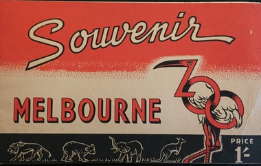
Booklet - Pictorial Souvenir of the Melbourne Zoo
Pictorial Souvenir listing Zoological Board Members, description of gardens and their history, general information, map, and profiles with photos of particular animals.Pictorial Souvenir listing Zoological Board Members, description of gardens and their history, general information, map, and profiles with photos of particular animals. Tourist booklet costing 1/-, Cover in red, black and white includes graphic design of flamingo and kangaroos. non-fictionPictorial Souvenir listing Zoological Board Members, description of gardens and their history, general information, map, and profiles with photos of particular animals. washfold family, melbourne zoo, melbourne -- tourist publications, christian-washfold collection -
 Kew Historical Society Inc
Map, MMBW, MMBW Town of Kew, 1910-21
The Melbourne and Metropolitan Board of Works (MMBW) was established by an act of the Victorian Parliament in 1890 to prepare for and to implement a sewerage and water reticulation system across what was then inner Melbourne, its surrounding and middle distance suburbs, including Kew. The MMBW was disbanded in 1991.The map collection of the Kew Historical Society has at its core the historic maps assembled and originally stored in the City Engineer's Department of the City of Kew. These include maps in a number of scales. The vast majority of maps were produced by the MMBW in the first two decades of the twentieth century, and are solid working maps, backed by linen for durability. These maps are historically significant to Kew, the City of Boroondara and to the history of the development of state utilities in Victoria. A number of the Kew maps have additional details added by former municipal officers, including the levels reached by various floods. As these were working documents, information was added to them long after the period of their initial production and distribution.Early map of the Town of Kew, created after 1910, at a scale 440 ft to 1 inch. The 'assembled' map by the City of Kew Engineer's Department includes scaled down copies of The Melbourne and Metropolitan Board of Works maps, Nos. 39, 40, 64, 65, 66, 67, 68, and 117. The map covers the entirety of the Town of Kew, bordered on its north and west by the River Yarra, by Burke Road in the East and Barkers Road in the south. The map shows the extent of urban development by that time, prominent institutions and the outlines of built structures in the municipality. TOWN OF KEW / SCALE 400 FEET TO 1 INCHmelbourne & metropolitan board of works, mmbw maps, mmbw plans, town of kew, cartography -
 Kew Historical Society Inc
Map, MMBW, MMBW Plan No.39 Kew & Heidelberg, 1900-1910
The Melbourne and Metropolitan Board of Works (MMBW) was established by an act of the Victorian Parliament in 1890 to prepare for and to implement a sewerage and water reticulation system across what was then inner Melbourne, its surrounding and middle distance suburbs, including Kew. The MMBW was disbanded in 1991.The map collection of the Kew Historical Society has at its core the historic maps assembled and originally stored in the City Engineer's Department of the City of Kew. These include maps in a number of scales. The vast majority of maps were produced by the MMBW in the first two decades of the twentieth century, and are solid working maps, backed by linen for durability. These maps are historically significant to Kew, the City of Boroondara and to the history of the development of state utilities in Victoria. A number of the Kew maps have additional details added by former municipal officers, including the levels reached by various floods. As these were working documents, information was added to them long after the period of their initial production and distribution.Early map of part of the Borough of Kew, created in the first decade of the twentieth century, at a scale 160 ft to 1 inch. The map covers what was then the north western section of Kew, bordered on its north by Wills Street and the Kew Lunatic Asylum, in the west by the River Yarra [and the later added Yarra Boulevard] , by Princess Street in the East and Holroyd Street in the south. The map shows the extent of urban development by that time, prominent institutions and the outlines of built structures in the municipality. Contour lines were added in ink to the map at a later stage.MELBOURNE AND METROPOLITAN BOARD OF WORKS / PLAN NO. 39 / KEW & HEIDELBERGmelbourne & metropolitan board of works, mmbw maps, mmbw plans, borough of kew, cartography -
 Kew Historical Society Inc
Map, MMBW, MMBW Plan No.40 Collingwood & Kew, 1900-1910
The Melbourne and Metropolitan Board of Works (MMBW) was established by an act of the Victorian Parliament in 1890 to prepare for and to implement a sewerage and water reticulation system across what was then inner Melbourne, its surrounding and middle distance suburbs, including Kew. The MMBW was disbanded in 1991.The map collection of the Kew Historical Society has at its core the historic maps assembled and originally stored in the City Engineer's Department of the City of Kew. These include maps in a number of scales. The vast majority of maps were produced by the MMBW in the first two decades of the twentieth century, and are solid working maps, backed by linen for durability. These maps are historically significant to Kew, the City of Boroondara and to the history of the development of state utilities in Victoria. A number of the Kew maps have additional details added by former municipal officers, including the levels reached by various floods. As these were working documents, information was added to them long after the period of their initial production and distribution.Early map of part of the Borough of Kew, created in the first decade of the twentieth century, at a scale 160 ft to 1 inch. The map covers what was then the south western section of Kew, bordered on its north by Studley Park Road, in the west by Walmer Street and the River Yarra, by High Street South and Princess Street in the East and Barkers Road in the south. The map shows the extent of urban development by that time, prominent institutions and the outlines of built structures in the municipality. Contour lines and historic flood levels were added in ink to the map at a later stage.MELBOURNE AND METROPOLITAN BOARD OF WORKS / PLAN NO. 40 / COLLINGWOOD & KEWmelbourne & metropolitan board of works, mmbw maps, mmbw plans, borough of kew, cartography -
 Kew Historical Society Inc
Map, MMBW, MMBW Plan No.64 Kew & Heidelberg, 1900-1910
The Melbourne and Metropolitan Board of Works (MMBW) was established by an act of the Victorian Parliament in 1890 to prepare for and to implement a sewerage and water reticulation system across what was then inner Melbourne, its surrounding and middle distance suburbs, including Kew. The MMBW was disbanded in 1991.The map collection of the Kew Historical Society has at its core the historic maps assembled and originally stored in the City Engineer's Department of the City of Kew. These include maps in a number of scales. The vast majority of maps were produced by the MMBW in the first two decades of the twentieth century, and are solid working maps, backed by linen for durability. These maps are historically significant to Kew, the City of Boroondara and to the history of the development of state utilities in Victoria. A number of the Kew maps have additional details added by former municipal officers, including the levels reached by various floods. As these were working documents, information was added to them long after the period of their initial production and distribution.Early map of part of the Borough of Kew, created in the first decade of the twentieth century, at a scale 160 ft to 1 inch. The map covers what was then the northern most part of Kew, bordered on its north and west by the Yarra River, in the East by Connor's Creek and by the Asylum in the south. The map shows the extent of urban development by that time, prominent institutions and the outlines of built structures in the municipality. Contour lines and historic flood levels were added in ink to the map at a later stage.MELBOURNE AND METROPOLITAN BOARD OF WORKS / PLAN NO. 64 / KEW & HEIDELBERGmelbourne & metropolitan board of works, mmbw maps, mmbw plans, borough of kew, cartography -
 Kew Historical Society Inc
Map, MMBW, MMBW Plan No.65 Kew & Heidelberg, 1900-1910
The Melbourne and Metropolitan Board of Works (MMBW) was established by an act of the Victorian Parliament in 1890 to prepare for and to implement a sewerage and water reticulation system across what was then inner Melbourne, its surrounding and middle distance suburbs, including Kew. The MMBW was disbanded in 1991.The map collection of the Kew Historical Society has at its core the historic maps assembled and originally stored in the City Engineer's Department of the City of Kew. These include maps in a number of scales. The vast majority of maps were produced by the MMBW in the first two decades of the twentieth century, and are solid working maps, backed by linen for durability. These maps are historically significant to Kew, the City of Boroondara and to the history of the development of state utilities in Victoria. A number of the Kew maps have additional details added by former municipal officers, including the levels reached by various floods. As these were working documents, information was added to them long after the period of their initial production and distribution.Early map of part of the Borough of Kew, created in the first decade of the twentieth century, at a scale 160 ft to 1 inch. The map covers what was then the south central part of Kew, bordered on its north by Malmsbury Street, in the west by Florence Avenue, in the south by Barkers Road, and in the east by Princess Street. The map shows the extent of urban development by that time, prominent institutions and the outlines of built structures in the municipality. Contour lines were added in ink to the map at a later stage.MELBOURNE AND METROPOLITAN BOARD OF WORKS / PLAN NO. 65 / KEW & HEIDELBERGmelbourne & metropolitan board of works, mmbw maps, mmbw plans, borough of kew, cartography -
 Kew Historical Society Inc
Map, MMBW, MMBW Plan No.66 Kew, 1900-1910
The Melbourne and Metropolitan Board of Works (MMBW) was established by an act of the Victorian Parliament in 1890 to prepare for and to implement a sewerage and water reticulation system across what was then inner Melbourne, its surrounding and middle distance suburbs, including Kew. The MMBW was disbanded in 1991.The map collection of the Kew Historical Society has at its core the historic maps assembled and originally stored in the City Engineer's Department of the City of Kew. These include maps in a number of scales. The vast majority of maps were produced by the MMBW in the first two decades of the twentieth century, and are solid working maps, backed by linen for durability. These maps are historically significant to Kew, the City of Boroondara and to the history of the development of state utilities in Victoria. A number of the Kew maps have additional details added by former municipal officers, including the levels reached by various floods. As these were working documents, information was added to them long after the period of their initial production and distribution.Early map of part of the Borough of Kew, created in the first decade of the twentieth century, at a scale 160 ft to 1 inch. The map covers what was then the south eastern part of Kew, bordered on its north by Adeney Avenue, in the west by Sackville Street, in the south by Barkers Road, and in the east by Burke Road. The map shows the extent of urban development by that time, prominent institutions and the outlines of built structures in the municipality. Contour lines were added in ink to the map at a later stage.MELBOURNE AND METROPOLITAN BOARD OF WORKS / PLAN NO. 66 / KEW melbourne & metropolitan board of works, mmbw maps, mmbw plans, borough of kew, cartography -
 Kew Historical Society Inc
Map, MMBW, MMBW Plan No.67 Kew, 1900-1910
The Melbourne and Metropolitan Board of Works (MMBW) was established by an act of the Victorian Parliament in 1890 to prepare for and to implement a sewerage and water reticulation system across what was then inner Melbourne, its surrounding and middle distance suburbs, including Kew. The MMBW was disbanded in 1991.The map collection of the Kew Historical Society has at its core the historic maps assembled and originally stored in the City Engineer's Department of the City of Kew. These include maps in a number of scales. The vast majority of maps were produced by the MMBW in the first two decades of the twentieth century, and are solid working maps, backed by linen for durability. These maps are historically significant to Kew, the City of Boroondara and to the history of the development of state utilities in Victoria. A number of the Kew maps have additional details added by former municipal officers, including the levels reached by various floods. As these were working documents, information was added to them long after the period of their initial production and distribution.Early map of part of the Borough of Kew, created in the first decade of the twentieth century, at a scale 160 ft to 1 inch. The map covers what was then the north central part of Kew, bordered on its north by the Outer Circle Railway Spruzen and Beresford Avenues, in the west by Princess Street, in the south by High Street, and in the east by (about) Belford Road. The map shows the extent of urban development by that time, prominent institutions and the outlines of built structures in the municipality. Contour lines were added in ink to the map at a later stage.MELBOURNE AND METROPOLITAN BOARD OF WORKS / PLAN NO. 67 / KEW melbourne & metropolitan board of works, mmbw maps, mmbw plans, borough of kew, cartography -
 Kew Historical Society Inc
Map, MMBW, MMBW Plan No.68 Kew, 1900-1910
The Melbourne and Metropolitan Board of Works (MMBW) was established by an act of the Victorian Parliament in 1890 to prepare for and to implement a sewerage and water reticulation system across what was then inner Melbourne, its surrounding and middle distance suburbs, including Kew. The MMBW was disbanded in 1991.The map collection of the Kew Historical Society has at its core the historic maps assembled and originally stored in the City Engineer's Department of the City of Kew. These include maps in a number of scales. The vast majority of maps were produced by the MMBW in the first two decades of the twentieth century, and are solid working maps, backed by linen for durability. These maps are historically significant to Kew, the City of Boroondara and to the history of the development of state utilities in Victoria. A number of the Kew maps have additional details added by former municipal officers, including the levels reached by various floods. As these were working documents, information was added to them long after the period of their initial production and distribution.Early map of part of the Borough of Kew, created in the first decade of the twentieth century, at a scale 160 ft to 1 inch. The map covers what was then the north central part of Kew, bordered in the north by Oak Avenue, in the west by the Yarra River and Connor's Creek, in the south by Beresford and Carnegie Avenues, and in the east by Glass's Creek and Burke Road. The map shows the extent of urban development by that time, prominent institutions and the outlines of built structures in the municipality. Contour lines and the levels of historic floods were added in ink to the map at a later stage.MELBOURNE AND METROPOLITAN BOARD OF WORKS / PLAN NO. 68 / KEW melbourne & metropolitan board of works, mmbw maps, mmbw plans, borough of kew, cartography -
 Kew Historical Society Inc
Map, MMBW, MMBW Plan No.117 Heidelberg & Kew, 1900-1910
The Melbourne and Metropolitan Board of Works (MMBW) was established by an act of the Victorian Parliament in 1890 to prepare for and to implement a sewerage and water reticulation system across what was then inner Melbourne, its surrounding and middle distance suburbs, including Kew. The MMBW was disbanded in 1991.The map collection of the Kew Historical Society has at its core the historic maps assembled and originally stored in the City Engineer's Department of the City of Kew. These include maps in a number of scales. The vast majority of maps were produced by the MMBW in the first two decades of the twentieth century, and are solid working maps, backed by linen for durability. These maps are historically significant to Kew, the City of Boroondara and to the history of the development of state utilities in Victoria. A number of the Kew maps have additional details added by former municipal officers, including the levels reached by various floods. As these were working documents, information was added to them long after the period of their initial production and distribution.Early map of part of the Borough of Kew, created in the early twentieth century, at a scale 160 ft to 1 inch. The map covers what was then the north eastern part of Kew showing the natural landscape and limited development on the south side of the Yarra River. In the Kew section, south of the river, the land is occupied currently by the Greenacres and Kew Golf Clubs. The map shows the extent of urban development by that time and the outlines of the few built structures in the municipality. The height above sea level of all parts of the landscape are indicated numerically in feet. Contour lines and the levels of historic floods were added in ink to the map at a later stage. MELBOURNE AND METROPOLITAN BOARD OF WORKS / PLAN NO. 117 / HEIDELBERG & KEW melbourne & metropolitan board of works, mmbw maps, borough of kew, cartography, mmbw plan no. 117, kew (vic.) -- maps, heidelberg (vic.) -- maps -
 Kew Historical Society Inc
Map, MMBW, River Yarra Beautification Schemes, c.1913
The Melbourne and Metropolitan Board of Works (MMBW) was established by an act of the Victorian Parliament in 1890 to prepare for and to implement a sewerage and water reticulation system across what was then inner Melbourne, its surrounding and middle distance suburbs, including Kew. The MMBW was disbanded in 1991.The map collection of the Kew Historical Society has at its core the historic maps assembled and originally stored in the City Engineer's Department of the City of Kew. These include maps in a number of scales. The vast majority of maps were produced by the MMBW in the first two decades of the twentieth century, and are solid working maps, backed by linen for durability. These maps are historically significant to Kew, the City of Boroondara and to the history of the development of state utilities in Victoria. A number of the Kew maps have additional details added by former municipal officers, including the levels reached by various floods. As these were working documents, information was added to them long after the period of their initial production and distribution.Map of the City of Kew showing part of the River Yarra Beautification Schemes. The map shows development to date and the flood levels reached in 1923 and 1924. This map may have been adapted from an earlier map, as most development in central Kew and Studley Park had occurred by this date yet numerous streets are not represented. Public buildings and institutions are clearly represented and named on the map as are significant public transport infrastructure (eg the Outer Circle railway).MELBOURNE AND METROPOLITAN BOARD OF WORKS / RIVER YARRA BEAUTIFICATION SCHEMES / SCHEME / SCALE 10 CHAINS TO AN INCHmelbourne & metropolitan board of works, mmbw maps, mmbw plans, city of kew, flood levels -- kew (vic.), cartography -
 Kew Historical Society Inc
Archive (series) - Subject File, Manchester Unity International Order of Foresters (MUIOOF)
Kew Historical SocietySince its foundation in 1958, members of the Kew Historical Society have been compiling and storing information about subjects relating to the history of Kew and its environs, of which this file is an example. Arranged by Secondary Values (value of records to users) Subject file created by researchers of the Kew Historical Society containing information about the Kew Branch of the MUIOOF. The file contains a number of primary and secondary sources, including a trifold syllabus for the first half of 1908 with accompanying advertisements for tradespeople in Kew. There are also newspaper articles from the 'Kew Mercury', items of correspondence, an invitation to a Ladies Night and a Report on the MUIOOF Yarra Yarra Lodge Honour Roll (Board?). The MUIOOF Yarra Yarra Lodge Honour Board is part of the physical collection of KHS. muioof -- kew (vic.), honour boards -- kew (vic.), friendly societies -- kew (vic.), union street -- kew (vic.), manchester unity international order of forestersmuioof -- kew (vic.), honour boards -- kew (vic.), friendly societies -- kew (vic.), union street -- kew (vic.), manchester unity international order of foresters -
 Sunbury Family History and Heritage Society Inc.
Photograph
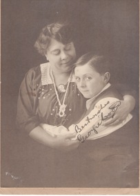
The following information is written on then back of the photograph - 'Wee Georgie Wood, English tutor'.A sepia studio photograph backed onto a light brown board of a lady and a young boy.Handwritten across the lower RHS: BEST WISHES/GEORGIE BOY. -
 Vision Australia
Photograph - Object, Lorna Lodge, 2004
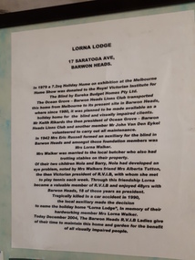
This board was constructed to provide information about the history of Lorna Lodge and to display some photographs and a newspaper cutting relating to this. The photographs are (clockwise): Photograph of Lorna Lodge on December 26, 1969 with a man standing outside and three children on the ramp leading to the front door. Photograph of Miss Elizabeth Skene, oldest member, at the 60th anniversary of the Barwon Heads auxiliary. Newspaper cutting: Ocean Grove News. Luncheon to help the blind. Ocean Grove has its fair share of fundraising groups. And the Royal Victorian Institute for the Blind, Ocean Grove Auxiliary is up there with the most hardworking. Pictured at the auxiliary's recent meeting are president Lorna Walker, secretary Vera Montgomery and treasurer Grace Brown. Talking of fundraising, the auxiliary will hold a casserole luncheon at the Ocean Grove Bowling Club on Monday, June 6 at noon. Tickets are available at the door at $5. Photograph of 60th anniversary in 2002 of RVIB Barwon Heads Mrs Grace Brown President and Yvonne Conners of Geelong West with a cake marking the occasion. Photograph of Bonnie Cameron and Vera Montgomery, RVIB Members holding a picture of the boat shed at Barwon Heads. Photograph of RVIB Life Members Achievement Award, awarded in recognition of support from Barwon Heads Auxiliary. Presented by Governor of Victoria John Landy at Government House on March 26th, 2003. L-R: Lorraine Gleeson, Jill Smith, Bonnie Cameron, Alice Donally, Wyn O'Brian, Una Harding and Dawn White. Photograph of Mrs Lorna Walker. In 1979 a 7.2 sq holiday home on exhibition at the Melbourne Home Show was donated to the Royal Victorian Institute for the Blind by Eureka Budget Homes Pty Ltd. The Ocean Grove - Barwon Heads Lions Club transported this home from Melbourne to it's present site in Barwon Heads, where since 1980, it was planned to be made available as a holiday home for the blind and visually impaired clients. Mr Keith Rikards the then president of Ocean Grove - Barwon Heads Lions Club and another member Mr John Van Den Eykel volunteered to carry out all maintenance. In 1942 Mrs Eric Russell formed an auxiliary for the blind in Barwon Heads and amongst these foundation members was Mrs Lorna Walker. Mrs Walker was married to the local butcher who also had trotting stables on their property. Of their two children, Nola and Barry, Nola had developed an eye problem, noted by Mrs Walker's friend Mrs Alberta Tutton, the then Victorian President of RVIB, with whom she met to play tennis with each week. Through this friendship Lorna became a valuable member of the RVIB and enjoyed 48 years with Barwon Heads, 18 of those years as President. Tragically killed in a car accident in 1990, the local auxiliary made the decision to name the holiday home 'Lorna Lodge', in memory of their hardworking member Mrs Lorna Walker. Today December 2004, The Barwon Heads RVIB Ladies give of their time to maintain this home and garden for the benefit of all visually impaired people.Image of board with photographs, text and newspaper cuttinglorna lodge, royal victorian institute for the blind -
 Federation University Art Collection
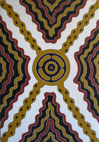
Painting - Acrylic on Board, Stuart Harradine (Wudja Waran), 'Tandurrum Jukuprrpa' by Stuart Harradine (Wudja Waran)
This item is part of the Federation University Art Collection. The Art Collection features over 2000 works and was listed as a 'Ballarat Treasure' in 2007.A stretched painting on canvas with Aboriginal motifs and colouring. If you can assist with information on this artist or artwork please make contact via the 'comments' link belowart, artwork, stuart harradine, wudja waran, aboriginal, horsham campus art collection -
 Federation University Art Collection
Artwork, A. Janczewski, Painting by A. Janczewski, 1990, 1990
This work used to hang at the entrance to the Geology Department at LaTrobe University.A colourful painting on composition board of a representation of a magnified geological specimen. If you have information on this artwork or artist please leave a message in the comment box below.artist, artwork, janczewski, geology -
 Vision Australia
Text, Sydney Industrial Blind Institution annual report (loose copies), 1903-1951
Annual reports produced by the SIBI, informing their subscribers and the general public of the good work undertaken by the Institute and the ongoing need for funding. Information provided included income, expenditure, fund raising, staff, services, etc. Below is a summary of other information contained in the reports. 1902 - Trades at which the blind are employed, extracts from visitors books, balance sheets, supplementary catalogue of books in library, subscription and donation lists by town, constitution of the institution and rules, sick fund rules and balance sheet. Also noted were the impending installment of a printing press for books, the development of blind distributors of tea beverages and that instead of a blind boys home, boys would instead be sent to board with suitable families. 1933 - A list of braille transcribers and the amount of braille produced, a brief report on the Floral Festival organised by the Women's Auxiliary Committee and the donation of a shop in George Street for 12 months for the selling of articles made by the Blind was provided by a SIBI committee member. 1934 - A brief report on the hostels at William Street and Woollahra, a detailed listing of all functions which raised money through the auspics of the auxiliaries, and a visit by Superintendent Hedge and Librarian Mr Thompson to the Croydon Ladies Social Club. 1938 - A radio show called the 'Glow Worm Session' on 2GB with home teacher Roy Kippax, the 150th anniversary of Sydney celebration and a 16 millimetre film that was made to publicise the Institute's work. 1939 - A record amount raised through the sale of goods made by Blind Workers, the refurbishment of "The Haven' at Woollahra and transfer of residents from William Street, and free admission by the Trocadero and Metro-Goldwyn-Mayer to swing concerts and 'Broadway Serenade'. 1940 - Incorporation of the Institute's Women's Magazine into Boomerang Magazine, the enlistment of two Board members Cohen and Meeks for active service, and a brief report from each of the branch auxiliaries. 1941 - The difficulty of obtaining stereotype Braille items from London and the passing of the editoress of the Women's Magazine Miss L.E. Hudson who had just completed the final edition. 1942 - Employment of 60 blind men and women in war related industries, the purchase of an air raid shelter and the small size of the report due to the shortage of paper. 1943 - Closure of the Basket department due to government regulations on cane stock, the provision of a lunch hour news service provided by visitors and individual reports from each of the Ladies Auxiliaries. 1944 - Presentation of a revolving chair to Honorary Librarian Mr H.W. Thompson for 35 years of service, the filling in of air raid trenches due to the improvement of the wartime situation and that SIBI had been supplying the Royal Australian Navy with mats, brushware and other products. 1945 - Continued placement of blind workers in outside industries, the compilation of a register of blind citizens and the election of the Hon. Justice Maxwell as President. 1946 - The successful application for Royal assent and the subsequent name change of the insitution, the intervention of Hon. Member C.R. Evatt Minister for Housing regarding the building of a new hostel for blind women and the establishment of an Honour Roll with a description of inductees Mrs K.L. Barry, Mrs J. Ayre, Mrs E. Vance . 1947 - Establishment of an occupational therapy department, the acceptance of Helen Keller to visit the society and the induction of Mrs Rivis Mead to the Honour Roll. 1951 - Passing of Librarian Miss Jean Currie and the use of prisoners to transcribe materials into Braille.Single volumes with various pagings, illustrations -
 Vision Australia
Administrative record (item) - Text, National Information Library Service, 79th Annual Report 1972-73 Braille and Talking Book Library, 1973
Annual report of the Braille & Talking Book Library including Minutes of the AGM, Board of Director's Report, President's report and financial statements. Items also included are: the name change from the Braille Library of Victoria, the passing of Neil Westh and Mary Mitchell, the retirement of Miss Anderson and funds raised by the Sixty Niners, Reservoir and Altona auxiliaries.corporation records, braille and talking book library -
 Vision Australia
Document - Text, Neil Maxwell 11th July 2001 - tributes
Hand written testimonies to Neil's work at AFB and VAF. The card reads: Dear Neil, Thank you for showing us the way. We look forward to working with you in all the Kooyong Committee's future endeavors. (Signed by) Margaret Deane, Judith Williams, Bette MacSween, Don Lee, Eve Lustig, Greg ?, Mavis ? The paper reads: Neil Maxwell has always been a very special person over the years he has been at Kooyong. He has been on the board of the Association for the blind from 1984-1993 and became a Director. Neil also became a Tour Guide on the 1st February 1989 and he was tutored by Marjory Lane, and he became very adept in learning new information very quickly. He worked with the Guides until the 7th April 1997. He has also joined the Kooyong Committee and became Chairman in 1998. Neil has given a lot of years to Vision Australia Foundation. He has always been a giver not a taker. Thank you Neil from The Kooyong Committee.Collection of cards paying tribute to Neil Maxwellnon-fictionelizabeth maxwell, neil maxwell -
 University of Melbourne, Burnley Campus Archives
Photograph - Black and white prints, Information Branch Victorian Department of Agriculture, Graduation 1974-1975, 1974-1975
(1) Graduation Day speeches, Tom Kneen, Eric Littlejohn seated. Ref. No. 1974(120-1. (20 Student receiving award Ref. No. 1974(120-22). (3) Student holding up Tennis Award Board Ref. No. 1974(120-24). (4) 7 "Rejects" not scanned. (5) Handwritten correspondence from L.T. Metzeling to J.T. Wilcox re photographs..Photograph by Information Branch Victorian Department of Agriculture.graduation day, speeches, t.h kneen, eric littlejohn, students, awards, tennis award, l.t. metzeling, j.t. wilcox -
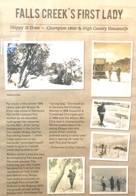 Falls Creek Historical Society
Poster - Falls Creek's First Lady
Skippy St Elmo - Champion Skier and High Country Housewife. For much of the winter 1945 newly married Skippy St Elmo was alone in Wallace's Hut while her husband Toni worked as an assistant hydrographical observer for the SEC. During her first two weeks Skippy had her first ski lesson and promised herself that someday she would be able to ski. Before winter's end she was accompanying Toni around the snow gauges. The following year, Skippy and Toni became the first full time residents of Falls Creek. Along with a group of other SEC workers they built the first lodge at Falls Creek, “Skyline” in 1947. Not only did Skippy fulfill her promise to be able to ski but also went on to become the Victorian Women's 1949 Downhill & Combined Champion and in 1954 won the Albury Ski Club Men's championship. While modest about her skiing success, Skippy was very proud of her domestic skills and cooking prowess using a camp oven. She also was spent time sewing ski wear for both Toni and herself. Skippy definitely earned the title of “Falls Creek’s First Lady”.This item is significant because it documents a pioneering figure of Victorian skiing.Poster composed of photos and text explaining basic information about Skippy St. Elmo mounted on display board.skippy st elmo, key figures of falls creek, skyline -
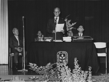
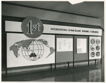 Royal District Nursing Service (now known as Bolton Clarke)
Photograph - Photograph, black and white, Barry Sutton, 05.02.1970
This sign was displayed at the 1st International Domiciliary Nursing Congress which was hosted by the Royal District Nursing Service (RDNS).The 1st International Domiciliary Nursing Congress was hosted by Royal District Nursing Service (RDNS). Mrs. D.(Elsa) Hallenstein, President of RDNS, presided over the opening ceremony with the Prime Minister of Australia, the Hon John Gorton opening the Congress. It was held in Melbourne and ran from the 1st to the 8th of February 1970. Many delegates came from around Australia and overseas; from the World Health Organisation; from the North American continent; from Europe, from Asia and from the Pacific. Black and white photograph showing the sign displayed at the 1st International Domiciliary Nursing Congress. Across the photograph is a long black metal stand, with eight legs, which holds a large board. On the upper quarter can be seen to the left a medium sized black circle which has the lettering '1st' outlined in white on it. To the right of this is the black lettering "International Domiciliary Nursing Congress" in capital letters on a white background. Below the black circle, on a white background, is a large round white globe outlined in black and with black spaced vertical and horizontal grids on it. In the lower centre of this is the black coloured land mass of Australia. Over the left hand top section, and above and to each side of the white globe are different land masses of the world displayed in grey. To the right of this there are two grey sections which are divided vertically with a black line,.and contain information on white sheets. To the right of that is a white section with round photographs in three pairs running down the board.Photographer stamp. Quote No. JE 4royal district nursing service, rdns, mrs d. (elsa) hallenstein, hon john gorton, 1st international domiciliary nursing congress -
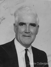 Melton City Libraries
Photograph, Tom Barrie, Unknown
Son of Jessie and Charles Ernest Barrie of Darlingsford Melton Married Marion Ferris at Christ Church Melton on 11th May 1939. They lived on the family farm at Ferris Road Melton. They had one son, Ian who has continued in farming in Melton. He served the community in the following – Shire of Melton Councillor Member for 32 years 1941 – 1970 Elected as Councillor for Melton South 1970 – 1973 Councillor for Rockbank 1943 – 1944 Shire President for three terms 1958 – 1959 ditto 1964 – 1965 ditto Council Representative: Bacchus Marsh High School and Western Suburbs Municipalities. Representative on delegation to prevent Melton post primary students being sent to Deer Park prior to the establishment of Melton High School. Melton Bush Fire Brigade 1941 Member Melton Bush Fire Brigade Registered No. 425 1942 1942 2nd Lieutenant 1943 – 1944 4th Lieutenant Country Fire Authority Rural Services Award 1963 20 Years Long Service Badge Scots Presbyterian Church Melton Member of the Board of Management 1947 – 1969 information from Annual Reports Tom farmed the family property with his father and brothers, and later the Ferris Road property which continued with his son Ian. His childhood interest in horses began with the draft horses kept at the bluestone stable and barn at Darlingsford. When the stables were empty in the late 1980s visit, he vividly recalled the names of the horses he had handled in his youth. When the draft horse became obsolete with the introduction of tractors and trucks this interest continued with the breeding and training of harness racers. Darlingsford Drafts and Ponies. Order of Stalls Clydesdales – Dick, Dolly, Flower, Nugget, Blossom, Lofty, Prince. Roger, Rose, Violet, Don, Beauty, Baldy, Diamond. Cart and Mounts Creamy, Digger, Popsy Black and white photographs of Tom Barrielocal identities -
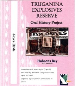 Truganina Explosives Reserve Preservation Society Inc (TERPS)
Digitised Oral History – Truganina Explosives Reserve - Tape 2 Joyce Hyde, 2018
The interviews were recorded in 2000 by Bronwen Gray and Alan Young for the production of Unreserved, Stories from Truganina Explosives Reserve, animated stories from past residents, workers and interested people of the Reserve (subject to copyright 2004). Joyce Hyde was married to Joe (Lesley) Hyde, the last Officer in Charge of the Truganina Explosives Reserve. They moved into the weather board house on 11 December 1952 when Joe was the assistant manager of the Reserve. They moved into the brick house when Joe was appointed Officer in Charge in 1956. Even though the site closed in 1962 and Joe was transferred to the head office in Spencer Street as Explosives Inspector, the Hyde family continued to live in the brick house. Joyce discusses her life at the Explosives Reserve and the early development of Altona. A primary source of information on memories of the Truganina Explosives Reserve and Altona,VictoriaDigital copy of original cassette recorded in 2000 and digitised in 2018altona, upton street altona, harrington court, coal mine, horse trough, mr piper, diggers hall, owen hyde, clive hyde, joe hyde, salt works, horse drawn explosives trucks -
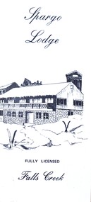 Falls Creek Historical Society
Flyer - Spargo Lodge
Ivan Spargo was a builder in Melbourne. In 1965 he and his wife Joy leased piece of land in Falls Creek and built Spargo Lodge. It was a dormitory style chalet designed to accommodate large groups and families. Their son, Rob and his wife Blanche purchased the site where the Falls Creek Hotel is today. In 1970 Rob’s sister Leonie and her husband Glenn joined the business, and they started operating in 1972. The family has been actively involved in the Falls Creek Community including the establishment of the Falls Creek Primary School and Falls Creek Search & Rescue. Rob also served as a member the Chamber and Resort Management Board. As the next generation stepped into the family business, Rob and Blanche retired to their home in Tawonga South in 2014 and Leonie and Glenn retired to Melbourne in 2017.This brochure is significant because it is linked to a prominent business and family in Falls Creek, Victoria. A small brochure publicising Spargo Lodge, Falls Creek. It is printed in brown text on buff coloured light card. When unfolded, one side shows a sketch of Spargo Lodge. The reverse side gives information about facilities and services, the tariff for regular and peak season, booking details and transport information.On front: Spargo Lodge FULLY LICENSED Falls Creekspargo lodge, falls creek accommodation, falls creek hotel