Showing 2708 items matching "demolished buildings"
-
 Eltham District Historical Society Inc
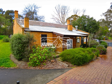
Photograph, Jim Connor, Shillinglaw Cottage, Panther Place, Eltham, 17 Aug 2015
... Shillinglaw Cottage looks stable enough now but it was the first colonial building in Australia to be pulled apart brick by brick and reconstructed on a different site. Community outrage prevented the council from demolishing the cottage in 1963 to make way for Eltham’s Shire Offices and local people paid for the cottage to be moved. ...Eltham District Historical Society Inc 728 Main Rd Eltham melbourne Shillinglaw Cottage looks stable enough now but it was the first colonial building in Australia to be pulled apart brick by brick and reconstructed on a different site. Community outrage prevented the council from demolishing the cottage in 1963 to make way for Eltham’s Shire Offices and local people paid for the cottage to be moved. ...Shillinglaw Cottage looks stable enough now but it was the first colonial building in Australia to be pulled apart brick by brick and reconstructed on a different site. Community outrage prevented the council from demolishing the cottage in 1963 to make way for Eltham’s Shire Offices and local people paid for the cottage to be moved. Originally built by respected local builder George Stebbing in 1859, the cottage is typical of European farmhouses, but is constructed of handmade local bricks in a style known as “Flemish Bond.” The chequered pattern created by the burnt “header” bricks is a unique feature of this style. The cottage’s name comes from its long association with the Shillinglaw family, who loved there for more than eighty years. The Cottage is classified by the National Trust. Tomorrow's history documented todayeltham, jim connor collection, main road, shillinglaw cottage -
 Eltham District Historical Society Inc
Photograph, Jim Connor, Main Road, Eltham, 14 Jan 2017
... The building was reportedly demolished by August 2021....The building was reportedly demolished by August 2021. Tomorrow's history documented today eltham jim connor collection main road eltham gateway Born digital Main Road, Eltham Photograph Photograph Jim Connor ...Eltham Gateway, 860 Main Road, Eltham Situated on a large block of approximately 1,442 sq metres, it was last sold for $1.4 million 30 Oct. 2016. The premises had been left in an abandoned state for some time and on the evening of 6 July 2021 it was attended by the CFA and 8 emergency vehicles due to a fire. Breathing apparatus was required due to hazardous smoke conditions. The building was reportedly demolished by August 2021.Tomorrow's history documented todayeltham, jim connor collection, main road, eltham gateway -
 Eltham District Historical Society Inc
Audio - Audio Recording, Audio Recording; 2018-06-13 Jim Connor and the history of the former Shire of Eltham office site, 13 Jun 2018
... In 1964 the then Shire of Eltham purchased the Shillinglaw property with the intention of demolishing the cottage and constructing new Shire offices on the site. However extensive community action resulted in funds being raised to have the building saved and relocated further south to the Eltham Common, where it was joined by the Eltham Library 1994. ...In 1964 the then Shire of Eltham purchased the Shillinglaw property with the intention of demolishing the cottage and constructing new Shire offices on the site. However extensive community action resulted in funds being raised to have the building saved and relocated further south to the Eltham Common, where it was joined by the Eltham Library 1994. ...June Meeting (Newsletter No. 240, Jun. 2018) Prior to Shillinglaw Cottage (c1878-80) being relocated to where it is now operated as a popular cafe near the Eltham Library, it was within Josiah Holloway’s 1850s subdivision known as Little Eltham, which later became the centre of the first Eltham township. Originally a farmer’s cottage it is historically significant because it is one of the Shire’s oldest dwellings and a fine example of the work of the well-known pioneer builder George Stebbing. In 1964 the then Shire of Eltham purchased the Shillinglaw property with the intention of demolishing the cottage and constructing new Shire offices on the site. However extensive community action resulted in funds being raised to have the building saved and relocated further south to the Eltham Common, where it was joined by the Eltham Library 1994. New Shire offices opened in 1965, but following municipal restructure in 1994 these were demolished and the land sold to a developer, which precipitated a dramatic trail of community angst, threats of legal action, the sacking of a newly elected council and several unsuccessful development proposals, by subsequent councils. After all these years the vacant site there is still guarded by the three trees that were outside the front of the Shillinglaw Cottage. At our Society meeting on Wednesday 13th June 2018 Jim Connor will speak about the dramatic tale encompassing the history of the former Eltham Shire office site and the adjoining War Memorial Buildings complex, which are now being considered for sale or redevelopment by the current Nillumbik Shire Council.1:17:57 duration Digital MP3 File 27 MB audio recording, eltham district historical society, jim connor, meeting, shire of eltham office site, society meeting -
 Eltham District Historical Society Inc
Photograph, Clearing land for Le Pine Funeral Home, cnr York Street and Main Road, Eltham, c.March 1998, 1998
... With this type of expert advice it is difficult to make a strong case for preservation of the building although, of course, it is a shame to see it demolished. The report includes details of the site itself and its history based on research carried out by Carlotta Kellaway. ...With this type of expert advice it is difficult to make a strong case for preservation of the building although, of course, it is a shame to see it demolished. The report includes details of the site itself and its history based on research carried out by Carlotta Kellaway. ...Newsletter No. 116, September, 1997 846-848 MAIN ROAD ELTHAM Nillumbik Shire Council has granted a permit for a funeral parlour on land which includes this site at the corner of Main Road and York Street. The site contains an architect's office in a building which was formerly a shop and dwelling dating from the 1920's. The proposal requires demolition of this building which is one of the few remaining old shops which formed the rather spread out "town centre" of Eltham. Prior to making its decision the Council obtained a report from Graeme Butler and Associates, the heritage consultants who carried out Stage 1 of the Nillumbik Heritage Study. The report summarized the historical significance as follows:- "This brick comer shop with associated residence has potential local historical significance as a late 1920's grocer's shop, now much altered and one of only a few shops of that era left in Eltham's Main Road. This significance is qualified by the many changes. The other examples are better preserved and still function as shops." With this type of expert advice it is difficult to make a strong case for preservation of the building although, of course, it is a shame to see it demolished. The report includes details of the site itself and its history based on research carried out by Carlotta Kellaway. The building dates from the late 1920's when it was owned by C.R. Nicholls. From the early 1930's it was Charles Cockroft's grocery shop and he also ran a grain store there. According to his daughter, Edna Brown, he delivered groceries around the district taking his truck as far as Kangaroo Ground. In 1950 he shifted to Traralgon. Since then several different businesses have operated from the site including a bottle merchant and produce store. Conversion to the present office use involved alterations to the shop front and rebuilding the galvanized iron store at the rear. Newsletter 119 March 1998 In our Newsletter No. 116 it was reported that the former shop on the comer of Main Road and York Street, Eltham was to be demolished as part of a funeral parlour development. If you have passed the site recently you will have noticed that it has now been demolished - another part of the old Eltham township has disappeared.Roll of 35mm colour negative film, 6 strips Also photographic prints 10 x 15 cmKodak Gold 200-6a.r. warren, eltham feed store, le pine funeral home, main road, york street, c.r. nicholls, charles cockcroft, grocery store -
 Eltham District Historical Society Inc
Photograph, Looking south along Main Road, Eltham near John Street, c.1970, 1970c
... The building on immediate left has since been demolished and is now the site of Goodstart Early Learning Eltham kinder...The building on immediate left has since been demolished and is now the site of Goodstart Early Learning Eltham kinder cba bank, John Street, Main Road, Pitt Street, Uniting Church 120 format 6x9 clr positive Looking south along Main Road, Eltham near John Street, c.1970 Photograph Peter Pidgeon ...Eltham Uniting Church and former CBA bank (later Opportunity Shop) in centre left. The building on immediate left has since been demolished and is now the site of Goodstart Early Learning Eltham kinder120 format 6x9 clr positivecba bank, john street, main road, pitt street, uniting church -
 Eltham District Historical Society Inc
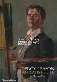
Book, Percy Leason: an artist's life by Margot Tasca, 2016
... buildings from a rundown apple orchard. Here they would build a new home. ·with financial assistance from The Herald, Leason bought the property and immediately commissioned an architectural firm to design a new house in the popular bungalow style of the time. The old farm house was demolished...buildings from a rundown apple orchard. Here they would build a new home. ·with financial assistance from The Herald, Leason bought the property and immediately commissioned an architectural firm to design a new house in the popular bungalow style of the time. The old farm house was demolished ..."Who would have thought that a boy born in 1889 from the Victorian Mallee would become a successful artist on New York’s Staten Island? This finely illustrated, exhaustively researched and beautifully written biography on Leason features the artist’s entire career as a painter and cartoonist renowned for his depictions of Australian society in the 1920s and 1930s. Leason’s story is a poignant one tracing his beginnings as a cartoonist, to the bohemian Melbourne art scene in the early 20th century, to his involvement in the artists’ camps of Eltham, to his important series of portraits of Lake Tyers Indigenous Australians, and his eventual move to the US where he has been acknowledged as making an enormous contribution to the New York arts scene. This story, as yet untold, fills a gap in the history of art in Australia and offers a new perspective on Australian art in the first half of the 20th century." - Thames and Hudson website A NEW HOME IN ELTHAM Once they had settled back into Melbourne, Perry and Belle began to look for a place to make a permanent home. Having enjoyed the bush setting of Mosman, they decided to explore the rural fringes of Melbourne. Each weekend they packed a picnic and travelled to the towns in the nearby hills - such as Ferntree Gully, Sassafras, Lilydale and, of course, Cockatoo Creek. Eventually deciding these places might be a little too far from The Herald office, they searched closer to the city. The Heidelberg and Box Hill regions that had inspired his old teacher McCubbin, had become busy, urban areas but further east, towards Warrandyte and Templestowe, there were still large tracts of bush. Finally they settled on Eltham, an area Percy knew very well, having often painted there with Jock Frater. Perry's old friend Dick McCann and his wife Margery had also settled in Eltham. The township was fifteen miles from Melbourne and serviced by an electric train that went to the central Melbourne station of Flinders Street, near where The Herald offices were located. Eltham was a small village in 1925, separated from Melbourne by the Yarra River, and surrounded by orchards and large tracts of bush. Small farms dotted the landscape and the main businesses revolved around ironmongers, blacksmiths, and farming supplies. Of particular appeal to artists was Eltham Park, a large expanse of bushland bounded by the Yarra River on the south side and the Diamond Creek on the east. The park included a playing field that was busy on weekends with cricket or football matches, but for the rest of the week it was mostly empty and an ideal place to paint. The scenery there provided the inspiration for many paintings by Leason, Meldrum and other artists such as Colin Colahan and Peter (A.E.) Newburv. The Leasons found a rundown old farmhouse on four-and-a-half acres of land in New Street, now known as Lavender Park Road. The site was splendid, at the top of a gentle slope which gave panoramic views east to the Dandenong hills, south over the Templestowe orchards and north to Kinglake. The front lawn was taken over by onion grass (or wiregrass as Leason called it) and scattered about the property were many wattles and gum trees. Aloe cacti covered much to the front of the house, while old quince and lucerne hedges separated the house and out-buildings from a rundown apple orchard. Here they would build a new home. ·with financial assistance from The Herald, Leason bought the property and immediately commissioned an architectural firm to design a new house in the popular bungalow style of the time. The old farm house was demolished but Percy saved the siding boards, bricks and corrugated iron for the outbuildings of his new home. The new house was a two storey, triple brick with a large, gabled, terracotta tiled roof. It was situated at the very top of the slope. The paint and varnish were barely dry when the family moved in during the summer of 1925-26 and the fumes were overpowering in the heat. Despite the house being wired for electricity, power poles had not yet reached the area and initially the family had to rely on kerosene lamps and candles. When electricity did arrive, Leason reflected on the community's reception of electricity at the expense of the old growth gum tree corridors in his cartoon, Electricity comes to Wiregrass. The family had now grown to seven. Jack was nearly nine, Jean was seven, Marjory was four, Nancy was two and the baby Patricia was seven months old. Jack and Jean were enrolled in the local primary school down the hill. A retired farmer, Jock McMillan, came to live on the property and help out with the general maintenance. Jock built himself a shack and Belle provided him with meals. He was kept occupied building structures around the property·, such as the garage, the outside toilet, garden beds, trellis arbours and a number of ponds. The elderly, bearded Scotsman with his old hat and baggy pants also provided the inspiration for one of the characters Leason regularly included in his cartoons. Like Leason, Jock smoked a straight stemmed pipe. A neighbour was employed to help Belle with domestic chores, and so the family settled down to live comfortably in their new Eltham house. Two dogs, Maginary and Wodger, completed the large and vibrant household. “Percy Leason; an artist’s life” by Margot Tasca, Thames & Hudson Australia Pty Ltd, Port Melbourne 2016, pp 63-64 Hardback Bookpercy leason, margot tasca, biography, artist, landscape -
 Eltham District Historical Society Inc
Photograph, George Coop, A day in Melbourne, corner of Cathedral Place and Lansdowne Street, November 1962
... demolished to make way for development of the greater Cathedral area. The preserved tower is all that remains. This is a close view of St. Patrick’s College taken from the corner of Cathedral Place and Lansdowne Street. It appears the veranda is an early addition to the main building...demolished to make way for development of the greater Cathedral area. The preserved tower is all that remains. This is a close view of St. Patrick’s College taken from the corner of Cathedral Place and Lansdowne Street. It appears the veranda is an early addition to the main building ...Adjacent to Albert Street, St. Patrick’s Cathedral College School occupied this site 1854-1968 when it was controversially demolished to make way for development of the greater Cathedral area. The preserved tower is all that remains. This is a close view of St. Patrick’s College taken from the corner of Cathedral Place and Lansdowne Street. It appears the veranda is an early addition to the main building. In time, even it appears to have had its own modifications with window ‘fill-ins’ to create more enclosed spaces.Digital TIFF file Scan of 35mm Ilford FP3 black and white transparencycathedral place, lansdowne street, melbourne, st. patrick’s cathedral college school -
 Eltham District Historical Society Inc
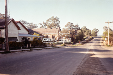
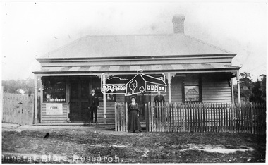
Photograph, General Store, Research, c.1900-c.1910
... A single chimney was unusual for a building like this. Store was demolished c. 1968 Cross Ref: SEPP_0501...A single chimney was unusual for a building like this. Store was demolished c. 1968 Cross Ref: SEPP_0501 This photo forms part of a collection of photographs gathered by the Shire of Eltham for their centenary project book,"Pioneers and Painters: 100 years of the Shire of Eltham" by Alan Marshall (1971). ...The original General Store at Research was also known as Doneys. It was located near where the present Main Road Research Shops are situated (opposite Ingrams Road). Charles Doney shown in front of the store. His wife Blanche is at the gate and his mother on the verandah. They had two boys Lance and Bill. The mother gave her daughter the opportunities and the graces. One of the children lived in a railway carriage behind the Church of England Research. A single chimney was unusual for a building like this. Store was demolished c. 1968 Cross Ref: SEPP_0501This photo forms part of a collection of photographs gathered by the Shire of Eltham for their centenary project book,"Pioneers and Painters: 100 years of the Shire of Eltham" by Alan Marshall (1971). The collection of over 500 images is held in partnership between Eltham District Historical Society and Yarra Plenty Regional Library (Eltham Library) and is now formally known as the 'The Shire of Eltham Pioneers Photograph Collection.' It is significant in being the first community sourced collection representing the places and people of the Shire's first one hundred years.Digital image, 18.5 x 29.5 cm print, 15.5 x 25.5 cm print and 120 format B&W negativesepp, shire of eltham pioneers photograph collection, research (vic.), general store, post office, doney family -
 Eltham District Historical Society Inc
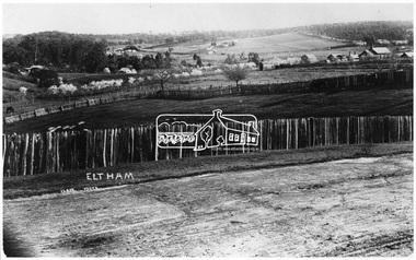
Negative - Photograph, J.H. Clark, Eltham - Looking towards High School from Pitt Street
... building on right. Photographer: J.H. Clark John Henry Clark was the youngest of three boys born to William Henry Clark (1823-1877) and Maria White (1843-1914). He and his brothers, William Charles Clark (1872-1945), Clement Kent Clark (1874-1912) operated a photography business (Clark Bros.) from 25 Thomas Street, Windsor near Prahran during the period c.1894 to 1914. Following death of Clement in September 1912 and their mother in 1914, the Clark Bros business appears to have dissolved, the premises demolished...building on right. Photographer: J.H. Clark John Henry Clark was the youngest of three boys born to William Henry Clark (1823-1877) and Maria White (1843-1914). He and his brothers, William Charles Clark (1872-1945), Clement Kent Clark (1874-1912) operated a photography business (Clark Bros.) from 25 Thomas Street, Windsor near Prahran during the period c.1894 to 1914. Following death of Clement in September 1912 and their mother in 1914, the Clark Bros business appears to have dissolved, the premises demolished ...Court House, Main Road, tallest building on right. Photographer: J.H. Clark John Henry Clark was the youngest of three boys born to William Henry Clark (1823-1877) and Maria White (1843-1914). He and his brothers, William Charles Clark (1872-1945), Clement Kent Clark (1874-1912) operated a photography business (Clark Bros.) from 25 Thomas Street, Windsor near Prahran during the period c.1894 to 1914. Following death of Clement in September 1912 and their mother in 1914, the Clark Bros business appears to have dissolved, the premises demolished, and a new house was under construction in 1915. John set up business independently in 1914 operating out of 29 Moor Street, Fitzroy where he is registered in the 1914 and 1915 Electoral Rolls. By 1916 John had relocated to Eltham where he continued his practice as a photographer and took many of the early images around the district of Little Eltham. Around 1930 John changed professions and opened a small cobbler's shop in 1931 near the pond opposite Dalton Street adjacent to the Jarrold family cottage. He never married and continued his profession as a bootmaker from this little shop, maintaining a close relationship with Mrs Jarrold for the rest of their lives. His bootmaker shop remains today beside the Whitecloud cottage and is one of only three remaining shops in the area from the early 20th century. There are a couple of images of Eltham taken by Clark Bros. in the Eltham District Historical Society collection, one such example being Hunniford’s Post Office with Miss Anne Hunniford out front (EDHS_00140 - marked on the back of the print, Clark Bros., 25 Thomas St. Windsor), which would date this image between c.1894 and 1914. Other early images of Eltham taken by John Henry Clark are marked on the face “J. H. Clark Photo” and it is assumed these are dated between 1914 and 1930. It is noted that the Grant of Probate for John H Clark of Eltham South dated 5 April !957 (513/387) records his occupation as "X Photographer". Source: Mr. L. Jarrold, Dromana, (formerly Eltham) and Mr. D. Jarrold, 74 Mark St., CoburgThis photo forms part of a collection of photographs gathered by the Shire of Eltham for their centenary project book,"Pioneers and Painters: 100 years of the Shire of Eltham" by Alan Marshall (1971). The collection of over 500 images is held in partnership between Eltham District Historical Society and Yarra Plenty Regional Library (Eltham Library) and is now formally known as the 'The Shire of Eltham Pioneers Photograph Collection.' It is significant in being the first community sourced collection representing the places and people of the Shire's first one hundred years.Digital image 4 x 5 inch B&W Neg (2 prints held by Eltham Library)sepp, shire of eltham pioneers photograph collection, eltham, main road, court house, j.h. clark photo -
 Eltham District Historical Society Inc
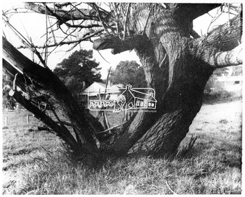
Negative - Photograph, George W. Bell, Gahan house, Main Road, Eltham, c.1964
... In 1964 the Shire of Eltham acquired the land upon which Shillinglaw Cottage stood for the purposes of building a new Shire Office. Shillinglaw Cottage was to be demolished but a campaign was managed by the local community to save Shillinglaw Cottage which was relocated to its present day site, (Panther Place, Eltham) immediately in front of the Gahan house as viewed in the photo. ...In 1964 the Shire of Eltham acquired the land upon which Shillinglaw Cottage stood for the purposes of building a new Shire Office. Shillinglaw Cottage was to be demolished but a campaign was managed by the local community to save Shillinglaw Cottage which was relocated to its present day site, (Panther Place, Eltham) immediately in front of the Gahan house as viewed in the photo. ...View of Gahan house originally known as 'Derril' framed by an old tree. Part of a collection of photos donated by George W. Bell to the former Shire of Eltham, c.1970. In 1964 the Shire of Eltham acquired the land upon which Shillinglaw Cottage stood for the purposes of building a new Shire Office. Shillinglaw Cottage was to be demolished but a campaign was managed by the local community to save Shillinglaw Cottage which was relocated to its present day site, (Panther Place, Eltham) immediately in front of the Gahan house as viewed in the photo. The Gahan house was subsequently demolished.This photo forms part of a collection of photographs gathered by the Shire of Eltham for their centenary project book, "Pioneers and Painters: 100 years of the Shire of Eltham" by Alan Marshall (1971). The collection of over 500 images is held in partnership between Eltham District Historical Society and Yarra Plenty Regional Library (Eltham Library) and is now formally known as 'The Shire of Eltham Pioneers Photograph Collection.' It is significant in being the first community sourced collection representing the places and people of the Shire's first one hundred years.Digital image 4 x 5 inch B&W Negsepp, shire of eltham pioneers photograph collection, eltham, shillinglaw cottage, gahan, gahan house, george w. bell collection, houses, main road, panther place, significant tree -
 Eltham District Historical Society Inc
Photograph, Officers in charge of Eltham Police Station (1857-2015), 22 Sep 2018
... In 1961 the Police in Eltham move into Pryor Street refurbished buildings and office. During 2001 to 2002, the Eltham Police Station was demolished and a new complex constructed on site. ...In 1961 the Police in Eltham move into Pryor Street refurbished buildings and office. During 2001 to 2002, the Eltham Police Station was demolished and a new complex constructed on site. ...The first Eltham Police Station was in the small building opposite Dalton Street rented from Mr Jarrold in 1857. In 1859 a dedicated Police Residence was built at 728 Main Road. A small weatherboard Police Station was attached to the side of the residence and a blue stone cell at the rear. Also on site were stables for the police horses. The Eltham Courthouse was built in 1860 and is the oldest public building in the district. In 1959 the Victoria Police purchased a house in Pryor Street to be refurbished as the Eltham Police Station. In 1961 the Police in Eltham move into Pryor Street refurbished buildings and office. During 2001 to 2002, the Eltham Police Station was demolished and a new complex constructed on site. The original 1859 Police residence is now home to the Eltham District Historical Society.albert frederick charles glover, allan fenton, arthur eggleston dungey, bertie stanton, charles briant, charles thomas martin, clyne harold mcphan, ebenezer williamson, eltham police station, gerard joseph o'toole, graham vincent joyce, harold shields, ian william bruce, isaac newton stevens, james boxhall, james chester draper, john scully, john stanley mcgough, john stuart bateman, john thomas cone, myles archibald lyons, peter lawlor, richard roberts, robert harry chrisfield, robert llewellyn, samuel james king, samuel o'donnell, sidney frederick little, thomas maher, victoria police, william charles sargeant, james francis fitzpatrick -
 Eltham District Historical Society Inc
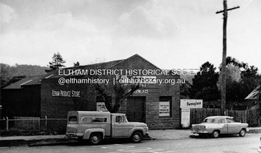
Photograph, Eltham Produce Store, c.1960
... building has signage to promote Tanox Paint and Permoglaze products. It also sold hay and grain. Operated by John McLean and Son. Situated just south from opposite Arthur Street, opposite the Eltham Village Shopping Centre. To the right was Garnet Burgess' second hand scrap metal and bottles, then the blacksmith shop, which was later taken over by Garnet with second hand furniture and next door to that was Ray Staff's grocery store. The store was demolished...building has signage to promote Tanox Paint and Permoglaze products. It also sold hay and grain. Operated by John McLean and Son. Situated just south from opposite Arthur Street, opposite the Eltham Village Shopping Centre. To the right was Garnet Burgess' second hand scrap metal and bottles, then the blacksmith shop, which was later taken over by Garnet with second hand furniture and next door to that was Ray Staff's grocery store. The store was demolished ...Two vehicles including a Holden FC Special Sedan and ca 1958 Ford 100 truck are parked outside the Eltham Produce Store, Main Road, Eltham near Arthur Street. The brick building has signage to promote Tanox Paint and Permoglaze products. It also sold hay and grain. Operated by John McLean and Son. Situated just south from opposite Arthur Street, opposite the Eltham Village Shopping Centre. To the right was Garnet Burgess' second hand scrap metal and bottles, then the blacksmith shop, which was later taken over by Garnet with second hand furniture and next door to that was Ray Staff's grocery store. The store was demolished by 1963 for the BP Evergreen Service Station. See also: Cross Ref 00161This photo forms part of a collection of photographs gathered by the Shire of Eltham for their centenary project book, "Pioneers and Painters: 100 years of the Shire of Eltham" by Alan Marshall (1971). The collection of over 500 images is held in partnership between Eltham District Historical Society and Yarra Plenty Regional Library (Eltham Library) and is now formally known as 'The Shire of Eltham Pioneers Photograph Collection.' It is significant in being the first community sourced collection representing the places and people of the Shire's first one hundred years.Digital image. Copy of original photograph. 4 x 5 inch B&W Neg 120 format B&W negative sepp, shire of eltham pioneers photograph collection, eltham, eltham produce store, main road, tanox paint, permoglaze, holden fc special sedan, ford 100 truck -
 Eltham District Historical Society Inc
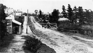
Photograph, View in Eltham looking south along Main road from Bridge Street, 1902
... building. The house on the right, 'Derril,' was purchased by Walter Gahan in 1924 and was demolished in 1968 when Main Road was widened. ...building. The house on the right, 'Derril,' was purchased by Walter Gahan in 1924 and was demolished in 1968 when Main Road was widened. ...Looking south along Main Road from the south side of the intersection of Bridge Street with Main Road. Post Office (Anne Hunniford Postmistress) on left then the Commercial Bank of Australasia building. The house on the right, 'Derril,' was purchased by Walter Gahan in 1924 and was demolished in 1968 when Main Road was widened. In the distance on the left is Watson's Hotel and on the right (opposite side of the main road, Morris's Hotel Cross Ref: 0624This photo forms part of a collection of photographs gathered by the Shire of Eltham for their centenary project book,"Pioneers and Painters: 100 years of the Shire of Eltham" by Alan Marshall (1971). The collection of over 500 images is held in partnership between Eltham District Historical Society and Yarra Plenty Regional Library (Eltham Library) and is now formally known as the 'The Shire of Eltham Pioneers Photograph Collection.' It is significant in being the first community sourced collection representing the places and people of the Shire's first one hundred years.Digital image Print 14 x 24 cm 35 mm B&W negativeanne jane hunniford (1855-1928), bridge street, commercial bank of australia, derril, eltham, gahan house, main road, morris's hotel, post office, shire of eltham pioneers photograph collection, watsons hotel -
 Eltham District Historical Society Inc
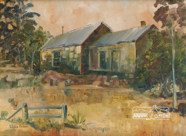
Painting, C. Lillie Brown, Briar Hill Cottage by C. Lillie Brown
... building. Frequented by children from the Briar Hill school which was opposite. House now demolished....building. Frequented by children from the Briar Hill school which was opposite. House now demolished. 25 Beaconsfield Road, Briar Hill, Miss Humphries, Lolly Shop, Briar Hill School 29.2 x 39.1 cm Oil on (Fredrix USA) linen mounted paper board 12" x 16 " (30.5 x 40.6 cm) in standard frame Signed in brown paint lower left C Lillie Brown Briar Hill Cottage by C. ...Painting by C. Lillie Brown (Caroline) of house at 25 Beaconsfield Road, Briar Hill, formnerly owned by Miss Humphries who ran a lolly shop in the left hand sode of the building. Frequented by children from the Briar Hill school which was opposite. House now demolished.29.2 x 39.1 cm Oil on (Fredrix USA) linen mounted paper board 12" x 16 " (30.5 x 40.6 cm) in standard frame Signed in brown paint lower left C Lillie Brown25 beaconsfield road, briar hill, miss humphries, lolly shop, briar hill school -
 Eltham District Historical Society Inc
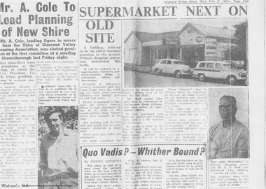
Newspaper clipping, Supermarket next on old site, Diamond Valley Mirror, Wed. Feb 17, 1965, p5, 1965
... demolished. Formerly a self-service grocery, restaurant and electrical repair shop, the building for many years housed Eltham’s only ‘family’ grocer and feed store. ...demolished. Formerly a self-service grocery, restaurant and electrical repair shop, the building for many years housed Eltham’s only ‘family’ grocer and feed store. ...In February 1965, Staffs Railway Store, the oldest business premises in the Eltham shopping district was demolished. Formerly a self-service grocery, restaurant and electrical repair shop, the building for many years housed Eltham’s only ‘family’ grocer and feed store. Earlier it had appeared to have been the town’s bakery. The building had been purchased in late March 1939 by Mr Eric N. Staff. At the time of E.N. Staff’s purchase there were huge bakers’ ovens located at the rear and the building also had a well and four toilets for employees. When the ‘pictures’ came to Eltham with the opening of the Eltham Public Hall across the road in 1941, Mr E.N. Staff extended the business and opened a milk bar and sweet shop. Further extensions re-established the tea rooms of days gone by. Mr E.N. Staff conducted business for about 15 years before handing over the reins to his son, Ray Staff. When his son Ray took over, the milk bar and tea rooms were closed for several years but the milk bar and was later re-opened and subsequently became a greengrocers and later again, a restaurant. The tea rooms section was converted to an electrical repair shop about 1955. Electoral Roll records for 1967 record Raymond Charles Staff at 929 Main Road, Eltham, grocer, and in 1968 at Lot 4, Hillcrest Avenue, Eltham, taxi truck operator. So it would appear that Ray continued to run the business for approximately two years after the original store was demolished and a new supermarket was built. Today, 929 Main Road is the Nongkhai Thai Restaurant and is precisely where the original Staffs store stood. Even though the facade has been modified at eye level with new larger windows, the upper facade is identical to that of the new Eltham Big Star Food Centre of 1965/66. But how did the original building, the oldest premises in the 1965 era shopping centre come about? On August 12th, 1902 at the Eltham Courthouse, appearing before T. Smallman, Esq,. Police Magistrate, and Messrs. W. Duncan and W.J. Taylor, Justices of the Peace is Luther Haley, baker. Wilfred Henry Johnston, by his agent Stanley Ernest Elder had applied for a warrant of ejectment under the Landlord and Tenant Act 1890 against Luther Haley from the bakery premises at the corner of Main Road and York Street. From the evidence presented we learn that Mrs Burgoyne of Eltham had purchased the property some months earlier from Mr Johnston, which consisted of a store and bakery establishment at Eltham occupied by Mr. Luther Haley, and whose lease expired some little time back, and up to the present time, Mr. Haley was not prepared to leave. He informed the court that he is unable to secure at Eltham a suitable house in which to carry on his business, but was building a place near the railway station which he expected to be done in about three weeks time, and he is then prepared to give up possession of the premises he now occupies. Mr Smallman informed the defendant, Luther Haley, that he will have to quit the premises in three weeks from the present date, and that a warrant of ejectment would be issued. However he also informed Mr Haley that he would order the warrant to lie in the office for three weeks from that date. The premises under construction referred to by Luther Haley in court were situated on the western side of Main Road, near the railway station slightly opposite present-day Arthur Street. It was opened around September 1902 as a General Store, Bakery and Tea Rooms. This was the original building in the present-day shopping precinct. At the time the only thing nearby was the railway station. Luther Haley’s business appeared to prosper and he would have catered to not only the locals abut also day visitors by train on Sundays coming up from Melbourne, offering fresh baked produce, tea rooms and summer drinks. The fields across Main Road running between present day Arthur Street and Luck Street were known as Haley’s Paddock and at times were used for community festivities and picnics. A newspaper report on the annual State schools picnic held at Haley’s Paddock on March 11, 1904 described it as “quite close to the railway station, and is quite capable of holding comfortably 10,000 people. With its ample shade and hilly surroundings, it is an ideal place for any gathering.” Luther Haley successfully ran his general store, bakery and tea rooms until 1917 when he and his family departed the district and moved to Westgarth Street in Northcote where he changed careers and became a publisher. It was then taken over by Hannah Lloyd and became known as Lloyd’s Railway General Store from 1917 to 1920. From then it had a succession of owners, one as short as two months until March 31, 1939 when the Grocery Business formerly carried on by Mr. T.K. White of Eltham for the previous eight years was purchased by Mr Eric N. Staff of Research and became known as E.N. Staff’s Railway Store. The ownership timeline for the store is as follows: Luther Haley Sep 1902-1917 Hannah Lloyd 1917-c.Feb 1920 Messrs J.R. & N.E. Lee 1920-Sep 1922 A. & E. Copeland Sep 1922-Sep 1925 Mr Price Sep 1925-Nov 1925 Mr Warren Nov 1925?-Nov 1926 A.W.J. Edwards Nov 1926-1931 T.K. White 1931-Mar 1939 Eric Staff Apr 1939-c.1954 Ray Staff c.1954-Feb 1965 then demolished Ray Staff Eltham Big Star Food Centre c.1965-1967 Digital file only from scan of copy on loan to EDHSa. copeland, a.w.j. edwards, big star food centre, e. copeland, eltham, eric staff, general store, hannah lloyd, j.r. lee, lloyd's general store, luther haley, main road, n.e. lee, price, ray staff, staffs general store, supermarket, t.k. white -
 Eltham District Historical Society Inc
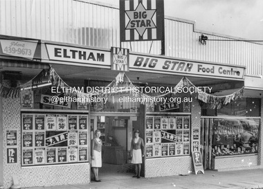
Photograph, Eltham Big Star Food Centre, Main Road, Eltham, c.1966
... demolished. Formerly a self-service grocery, restaurant and electrical repair shop, the building for many years housed Eltham’s only ‘family’ grocer and feed store. ...demolished. Formerly a self-service grocery, restaurant and electrical repair shop, the building for many years housed Eltham’s only ‘family’ grocer and feed store. ...In February 1965, Staffs Railway Store, the oldest business premises in the Eltham shopping district was demolished. Formerly a self-service grocery, restaurant and electrical repair shop, the building for many years housed Eltham’s only ‘family’ grocer and feed store. Earlier it had appeared to have been the town’s bakery. The building had been purchased in late March 1939 by Mr Eric N. Staff. At the time of E.N. Staff’s purchase there were huge bakers’ ovens located at the rear and the building also had a well and four toilets for employees. When the ‘pictures’ came to Eltham with the opening of the Eltham Public Hall across the road in 1941, Mr E.N. Staff extended the business and opened a milk bar and sweet shop. Further extensions re-established the tea rooms of days gone by. Mr E.N. Staff conducted business for about 15 years before handing over the reins to his son, Ray Staff. When his son Ray took over, the milk bar and tea rooms were closed for several years but the milk bar and was later re-opened and subsequently became a greengrocers and later again, a restaurant. The tea rooms section was converted to an electrical repair shop about 1955. Electoral Roll records for 1967 record Raymond Charles Staff at 929 Main Road, Eltham, grocer, and in 1968 at Lot 4, Hillcrest Avenue, Eltham, taxi truck operator. So it would appear that Ray continued to run the business for approximately two years after the original store was demolished and a new supermarket was built. Today, 929 Main Road is the Nongkhai Thai Restaurant and is precisely where the original Staffs store stood. Even though the facade has been modified at eye level with new larger windows, the upper facade is identical to that of the new Eltham Big Star Food Centre of 1965/66. But how did the original building, the oldest premises in the 1965 era shopping centre come about? On August 12th, 1902 at the Eltham Courthouse, appearing before T. Smallman, Esq,. Police Magistrate, and Messrs. W. Duncan and W.J. Taylor, Justices of the Peace is Luther Haley, baker. Wilfred Henry Johnston, by his agent Stanley Ernest Elder had applied for a warrant of ejectment under the Landlord and Tenant Act 1890 against Luther Haley from the bakery premises at the corner of Main Road and York Street. From the evidence presented we learn that Mrs Burgoyne of Eltham had purchased the property some months earlier from Mr Johnston, which consisted of a store and bakery establishment at Eltham occupied by Mr. Luther Haley, and whose lease expired some little time back, and up to the present time, Mr. Haley was not prepared to leave. He informed the court that he is unable to secure at Eltham a suitable house in which to carry on his business, but was building a place near the railway station which he expected to be done in about three weeks time, and he is then prepared to give up possession of the premises he now occupies. Mr Smallman informed the defendant, Luther Haley, that he will have to quit the premises in three weeks from the present date, and that a warrant of ejectment would be issued. However he also informed Mr Haley that he would order the warrant to lie in the office for three weeks from that date. The premises under construction referred to by Luther Haley in court were situated on the western side of Main Road, near the railway station slightly opposite present-day Arthur Street. It was opened around September 1902 as a General Store, Bakery and Tea Rooms. This was the original building in the present-day shopping precinct. At the time the only thing nearby was the railway station. Luther Haley’s business appeared to prosper and he would have catered to not only the locals abut also day visitors by train on Sundays coming up from Melbourne, offering fresh baked produce, tea rooms and summer drinks. The fields across Main Road running between present day Arthur Street and Luck Street were known as Haley’s Paddock and at times were used for community festivities and picnics. A newspaper report on the annual State schools picnic held at Haley’s Paddock on March 11, 1904 described it as “quite close to the railway station, and is quite capable of holding comfortably 10,000 people. With its ample shade and hilly surroundings, it is an ideal place for any gathering.” Luther Haley successfully ran his general store, bakery and tea rooms until 1917 when he and his family departed the district and moved to Westgarth Street in Northcote where he changed careers and became a publisher. It was then taken over by Hannah Lloyd and became known as Lloyd’s Railway General Store from 1917 to 1920. From then it had a succession of owners, one as short as two months until March 31, 1939 when the Grocery Business formerly carried on by Mr. T.K. White of Eltham for the previous eight years was purchased by Mr Eric N. Staff of Research and became known as E.N. Staff’s Railway Store. The ownership timeline for the store is as follows: Luther Haley Sep 1902-1917 Hannah Lloyd 1917-c.Feb 1920 Messrs J.R. & N.E. Lee 1920-Sep 1922 A. & E. Copeland Sep 1922-Sep 1925 Mr Price Sep 1925-Nov 1925 Mr Warren Nov 1925?-Nov 1926 A.W.J. Edwards Nov 1926-1931 T.K. White 1931-Mar 1939 Eric Staff Apr 1939-c.1954 Ray Staff c.1954-Feb 1965 then demolished Ray Staff Eltham Big Star Food Centre c.1965-1967 Research and copy: Peter Pidgeon (EDHS) Digital file only from scan of copy on loan to EDHSa. copeland, a.w.j. edwards, big star food centre, e. copeland, eltham, eric staff, general store, hannah lloyd, j.r. lee, lloyd's general store, luther haley, main road, n.e. lee, price, ray staff, staffs general store, supermarket, t.k. white -
 Eltham District Historical Society Inc
Slide, Maroondah Aqueduct, Research, Victoria, 22 Mar. 1981
... building of the aqueduct indicate that it was a significant construction achievement. The present Maroondah Reservoir was completed in 1927 and the aqueduct was enlarged at that time to take increased flows. About 1971 the section of the aqueduct through and north of Research was replaced by a large pipe and that section of the channel is now unused. The channel has remained largely intact (unlike sections at Greensborough and Bundoora where long lengths of the disused aqueduct have been demolished...building of the aqueduct indicate that it was a significant construction achievement. The present Maroondah Reservoir was completed in 1927 and the aqueduct was enlarged at that time to take increased flows. About 1971 the section of the aqueduct through and north of Research was replaced by a large pipe and that section of the channel is now unused. The channel has remained largely intact (unlike sections at Greensborough and Bundoora where long lengths of the disused aqueduct have been demolished ...An inspection tour of the Maroondah Aqueduct was undertaken by the Shire of Eltham Historical Society on Sunday, March 22nd, 1981, commening where the aqueduct crosses Main Rd., Research, just below Eltham College. The Maroondah Aqueduct was part of Melbourne’s water supply system. It carried water over the 66 km from the Maroondah Reservoir on the Watts River at Healesville to the Preston Reservoir. Of this length, 41 km were open channel, 10 km, tunnel through hills and 15 km in 14 inverted siphons across stream valleys. The route of the aqueduct is north of Tarrawarra and Yarra Glen, along the Yarra escarpment south of Christmas Hills and crossing Watsons Creek into the present Shire of Eltham near Henley Rd. The eastern part of the route lies entirely within the former boundaries of the shire. The aqueduct passes south of Kangaroo Ground to Research and crosses the Diamond Creek by siphon at Allendale Rd., Eltham North. It then extends to Reservoir via St. Helena, Greensborough North and Bundoora. Water first flowed through the aqueduct in February 1891 when it was fed by a diversion weir on the Watts River. Records of the building of the aqueduct indicate that it was a significant construction achievement. The present Maroondah Reservoir was completed in 1927 and the aqueduct was enlarged at that time to take increased flows. About 1971 the section of the aqueduct through and north of Research was replaced by a large pipe and that section of the channel is now unused. The channel has remained largely intact (unlike sections at Greensborough and Bundoora where long lengths of the disused aqueduct have been demolished or filled in). The M.M.B.W. relinquished control of the disused aqueduct reserve which is crown land and the Shire of Eltham took control of this section of the reserve as a linear park. The Maroondah Aqueduct is considered to be an important historic structure, not just to the local area but to the metropolitan area generally. It is considered important to preserve substantially intact long lengths of the disused aqueduct, together with its bridges and other associated structures. 35 mm colour positive transparency (1 of 5) Mount - Agfachrome Agfa CS System black 8 dotsactivities, heritage excursion, maroondah aqueduct, research (vic.), shire of eltham historical society -
 Eltham District Historical Society Inc
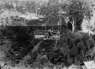
Photograph, Demolishing the Bini Shell at Diamond Creek, 1991, 1991
... Jan 2022 This was the first public building in Victoria to be erected using the Bini Shell design method of construction. 1991 diamond creek Bini Shell demolition oval Colour photograph Demolishing the Bini Shell at Diamond Creek, 1991 Photograph Photograph ...In 1978 Diamond Valley Shire recognised the need for a new public hall in Diamond Creek. Council considered the Bini shell form of construction which was in operation overseas and in use in New South Wales as libraries, gymnasiums, sports centres and multi-purpose centres. The Council gave the go-ahead. A site was chosen opposite the Hotel and close to the railway line. One day in - the following year, in 1979, activity stood still in Diamond Creek as school children and other excited spectators watched the one-hour inflation of the Bini Shell. This unusual method of construction was invented by Italian industrial designer and architect Dante Bini. The construction pneumatically raises a level of reinforced concrete from ground level which has not been set, using an internal balloon. The inner membrane inflates and compresses the mesh and concrete against the outer membrane. A net of flexible steel rods was laid on the building’s circular base, on the top of a fabric bladder. 300 tonnes of reinforced concrete were poured onto the mesh and a sealed cover laid over the concrete making a sandwich of cover, bladder and mesh. Compressed air was pumped into the bladder and the sandwich slowly began to rise and become a massive self-supporting dome. After inflation and removal of the outer membrane workmen filled in any holes. It was some days before pneumatic drills pecked out the first opening. The ceiling of the concrete dome was lined with fluffy insulating material. The dome was 36 metres in diameter at the base and 12 metres high in the centre with a usable floor space of 670 square metres. An opening night dinner was held to celebrate the new facility on March 12, 1980. Shire President Ron Pata made a speech and unveiled a plaque. It was the first public building in Victoria to be erected using the Bini Shell design method of construction The facility could cater for up to 400 people and in 1980 a fee for use was $100 for up to 200 people, $150 for up to 300 people and $200 for up to 400 people. For the next ten years or so, locals attended the hall for marital arts classes, basketball and netball games and school discoes and various other activities. After pieces of concrete fell off a Bini shell interstate due to a construction fault, the Council closed the centre. Demotion took place during the Diamond Creek Town Fair in 1991, as part of the annual Town Fair’s program. Research by L.P. Jan 2022This was the first public building in Victoria to be erected using the Bini Shell design method of construction.Colour photograph1991, diamond creek, bini shell, demolition, oval -
 Eltham District Historical Society Inc
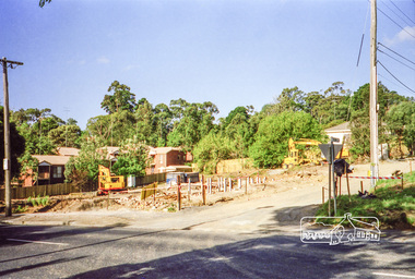
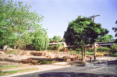
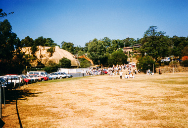
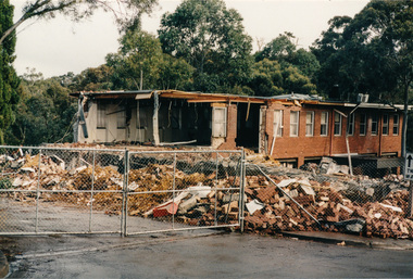
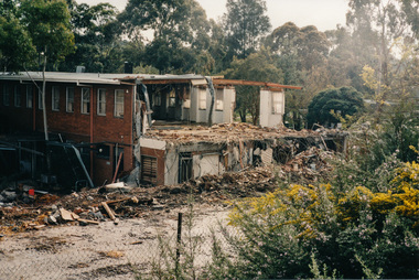
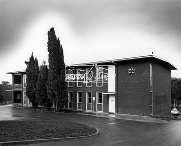
Photograph, Demolition of Eltham Shire Offices, 17 Aug 1996, 17/8/96
... demolished. 17 August, 1996. This followed Victorian Local Government re-amalgamations in 1994. This was a multi-story building which also included the Eltham Library....Eltham District Historical Society Inc 728 Main Rd Eltham melbourne shire of eltham demolition buildings Three colour photographs of the Shire of Eltham Council Offices, Main Road, Eltham being demolished. 17 August, 1996. ...Three colour photographs of the Shire of Eltham Council Offices, Main Road, Eltham being demolished. 17 August, 1996. This followed Victorian Local Government re-amalgamations in 1994. This was a multi-story building which also included the Eltham Library.shire of eltham, demolition, buildings -
 Eltham District Historical Society Inc
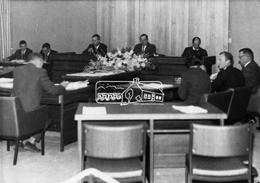
Photograph, Council Chamber. First meeting in new Shire Office, 1 May 1965, 01/05/1965
... building on 1 May 1965. The following were on Council in 1965. Cr. L.C. Docksey (President), Cr. R.N. Maskell, Cr. J. V. McConnell, Cr. Mrs E. M. Edwards, Cr. A. E.Cracknell, Cr. J.A. Lewis, Cr. F. J. Favier, Cr. D. C. O'Beirne, Cr. T.A. Collins and Cr. Charis Pelling, some of whom appear in this photograph. The Shire of Eltham Council offices were located at 895 Main Road Eltham and were demolished...building on 1 May 1965. The following were on Council in 1965. Cr. L.C. Docksey (President), Cr. R.N. Maskell, Cr. J. V. McConnell, Cr. Mrs E. M. Edwards, Cr. A. E.Cracknell, Cr. J.A. Lewis, Cr. F. J. Favier, Cr. D. C. O'Beirne, Cr. T.A. Collins and Cr. Charis Pelling, some of whom appear in this photograph. The Shire of Eltham Council offices were located at 895 Main Road Eltham and were demolished ...The first Council meeting in the brand new Eltham Shire Office building on 1 May 1965. The following were on Council in 1965. Cr. L.C. Docksey (President), Cr. R.N. Maskell, Cr. J. V. McConnell, Cr. Mrs E. M. Edwards, Cr. A. E.Cracknell, Cr. J.A. Lewis, Cr. F. J. Favier, Cr. D. C. O'Beirne, Cr. T.A. Collins and Cr. Charis Pelling, some of whom appear in this photograph. The Shire of Eltham Council offices were located at 895 Main Road Eltham and were demolished in August 1996.This photo forms part of a collection of photographs gathered by the Shire of Eltham for their centenary project book, "Pioneers and Painters: 100 years of the Shire of Eltham" by Alan Marshall (1971). The collection of over 500 images is held in partnership between Eltham District Historical Society and Yarra Plenty Regional Library (Eltham Library) and is now formally known as 'The Shire of Eltham Pioneers Photograph Collection.' It is significant in being the first community sourced collection representing the places and people of the Shire's first one hundred years.Digital imagesepp, shire of eltham pioneers photograph collection, eltham, shire president, council chamber, eltham shire office, meeting -
 Eltham District Historical Society Inc
Photograph, Hugh Fisher, Eltham - Shire Office, 1968
... They were demolished in August 1996. Note the historic Shillinglaw trees at the front of the building....They were demolished in August 1996. Note the historic Shillinglaw trees at the front of the building. ...Completion of stage one of the new Eltham Shire Office located at 895 Main Road Eltham. They were demolished in August 1996. Note the historic Shillinglaw trees at the front of the building.This photo forms part of a collection of photographs gathered by the Shire of Eltham for their centenary project book, "Pioneers and Painters: 100 years of the Shire of Eltham" by Alan Marshall (1971). The collection of over 500 images is held in partnership between Eltham District Historical Society and Yarra Plenty Regional Library (Eltham Library) and is now formally known as 'The Shire of Eltham Pioneers Photograph Collection.' It is significant in being the first community sourced collection representing the places and people of the Shire's first one hundred years.Digital imagesepp, shire of eltham pioneers photograph collection, eltham, eltham shire office, muncipal buildings -
 Eltham District Historical Society Inc
Photograph, Allwood, Hurstbridge, 1885
... demolished. Gray, a fruit grower established an orchard and Allwood Nurseries which became a very successful business growing and exporting. This is probably around the time when this photo was taken where rows of fruit trees can be seen in the foreground. A house and associated buildings...demolished. Gray, a fruit grower established an orchard and Allwood Nurseries which became a very successful business growing and exporting. This is probably around the time when this photo was taken where rows of fruit trees can be seen in the foreground. A house and associated buildings ...Allwood at Hurstbridge was named and first settled in 1837 by the Haley family. A house was built of one round of vertical slabs (red gum). Later it was the Hurst family home where Henry Hurst was shot by Burke the Bushranger on 4 October 1886. George Gray took over the property and the original home was eventually demolished. Gray, a fruit grower established an orchard and Allwood Nurseries which became a very successful business growing and exporting. This is probably around the time when this photo was taken where rows of fruit trees can be seen in the foreground. A house and associated buildings, possibly part of the nursery are behind. This photo forms part of a collection of photographs gathered by the Shire of Eltham for their centenary project book, "Pioneers and Painters: 100 years of the Shire of Eltham" by Alan Marshall (1971). The collection of over 500 images is held in partnership between Eltham District Historical Society and Yarra Plenty Regional Library (Eltham Library) and is now formally known as 'The Shire of Eltham Pioneers Photograph Collection.' It is significant in being the first community sourced collection representing the places and people of the Shire's first one hundred years.Digital imagesepp, shire of eltham pioneers photograph collection, diamond creek, hurstbridge, allwood, orchard -
 Eltham District Historical Society Inc
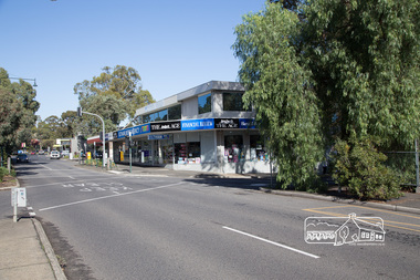
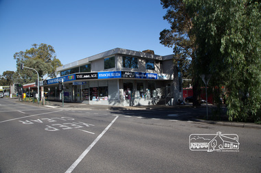
Photograph, Peter Pidgeon, Newsagency, Main Road, Eltham, 3 May 2017, 3 May 2017
... demolished. Post Office has moved up from the original location but still in same building complex. ...demolished. Post Office has moved up from the original location but still in same building complex. ...Former site of the Post Office, then Priceline and now the relocated Newsagency; the former site across Main Road being demolished. Post Office has moved up from the original location but still in same building complex. Railway Station and carpark to the right.Born Digitaleltham, railway station, eltham railway station, carparks, newsagency -
 Eltham District Historical Society Inc
Photograph, Peter Pidgeon, Newsagency, Main Road, Eltham, 3 May 2017, 3 May 2017
... demolished. Post Office has moved up from the original location but still in same building complex. ...demolished. Post Office has moved up from the original location but still in same building complex. ...Former site of the Post Office, then Priceline and now the relocated Newsagency; the former site across Main Road being demolished. Post Office has moved up from the original location but still in same building complex. Railway Station and carpark to the right.Born Digitaleltham, railway station, eltham railway station, carparks, newsagency