Showing 9551 items
matching east street
-
 Stawell Historical Society Inc
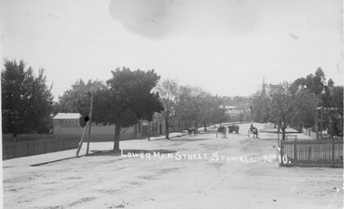
Photograph, Lower Main Street Stawell looking East c1905. Merle Photographic Studio at Left
... Lower Main Street Stawell looking East c1905. Merle...Lower Main Street looking East from Railway gates. Shows... grampians Lower Main Street looking East from Railway gates. Shows ...Lower Main Street looking East from Railway gates. Shows four horse drawn vehicles. The photo was taken from the railway gates towards the main shopping area. The Presbyterian spire can be seen in the back ground. c1905.Sepia Postcard of a street scene the roadway is central in picture featuring 4 horse drawn vehicles. Street is tree lined with picket fence on right side of photograph. 0007a taken opposite the Diamond house looking down Seaby St. toward the railway crossing.Lower Main Street Stawell No 10. is inscribed on the front and The "Merle Studio" Main Street, Stawell on the back.stawell shops business streetscape building transport -
 Melbourne Tram Museum
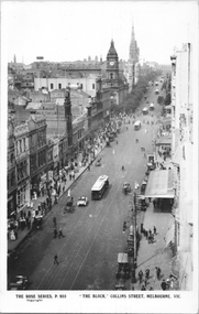
Postcard, Rose Stereograph Co, "'The Block' - Collins Melbourne ", c1910
... ' - Collins Melbourne " looking east from Elizabeth Street. Has... Melbourne " looking east from Elizabeth Street. Has at least nine ...Rose Series postcard No. P 955, titled "'The Block' - Collins Melbourne " looking east from Elizabeth Street. Has at least nine cable trams in the view, along with horse drawn vehicles and motor cars. Has signs for James Thelwell ladies Tailor and Lafayette. The verandah on the south side of Collins Street is part of the "Centreway Arcade" and building constructed in 1911-12.Yields information about Collins St, c1914.Postcard - printed real photograph with Rose Stereograph Co. name on the rear.Has the Ken Magor stamp on the rear.trams, tramways, cable trams, collins st, melbourne town hall -
 Lakes Entrance Regional Historical Society (operating as Lakes Entrance History Centre & Museum)
Photograph - Bullock Island Lakes Entrance, Holding M, 2000 c
... from western boat ramp east to Orme Street continued from 04216... western boat ramp east to Orme Street continued from 04216 number ...photographs showing view of town from across North Arm from western boat ramp east to Orme Street continued from 04216 number 04216.1 and 04216.2 size 10 x 15 cm|. Colour photograph of town from Kalimna Heights showing Hill 60 on Hummocks taken 1975 c printed from slide number 04216.3Colour photograph of western end of town taken from Kalimna Heights showing cars parked near western boat ramp and North Arm, hummocks and Bass Strait in distance, Lakes Entrance Victorialookouts, gippsland lakes, topography, buildings, bullock island -
 Wodonga & District Historical Society Inc
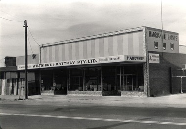
Photograph - Mann Collection Album - Wiltshire & Rattray Plumbers, C. 1968
... Bob Wiltshire and Ron Rattray built this store on the East... on the East side of High Street, next to the Railway signal box ...Elaine Mann was married to David Mann, a successful Wodonga businessman and community leader who passed away in Wodonga in June 2012. David was a member of the Mann family who began their business in Wodonga in 1920. Elaine was a teacher in Wodonga for many years and an active member of the community.This photo collection is significance as it documents how the businesses and buildings in Wodonga have evolved and contributed to community throughout the late 20th century.Bob Wiltshire and Ron Rattray built this store on the East side of High Street, next to the Railway signal box. The site had formerly been occupied by Abe Turton’s Coach building business. The building has since had several tenants, including “Lunn & Fordyce” clothingwodonga businesses, high st wodonga, wiltshire and rattray -
 Ringwood and District Historical Society
Photographs, Ringwood East House letter and photos taken from end of Coolooli Court. Exact position unknown. C1930's, c.1930s
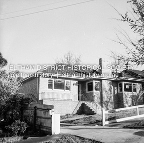
... further down the hill with a long driveway from Cleland Street... with a long driveway from Cleland Street, Ringwood East. 5 black ...Typed letter with the photos gives some of the history of the house although the exact position is unknown. The photos were taken at the end of Coolooli Court. The house was later moved further down the hill with a long driveway from Cleland Street, Ringwood East.5 black and white photos of timber home set in large garden in Ringwood East; Covering letter from photographer -
 Eltham District Historical Society Inc
Album - Photograph, J.A. McDonald, Eltham-Greensborough Road, July 1956
... looking to Main Road View looking east up Bridge Street to Main... looking to Main Road View looking east up Bridge Street to Main ...Diamond Creek Bridge (Bridge Street Bridge) General view looking to Main Road View looking east up Bridge Street to Main Road prior to widening. The Eltham Obelisk is located at the top of the hill on the left but was relocated to the Eltham RSL front garden as a reesult of road widening works and improvements to the intersection. On the immediate right is the present-day Eltham Rugby Union ovalRecord of various Shire of Eltham infrastructure works undertaken during the period of 1952-1962 involving bridge and road reconstruction projects, sometimes with Eltham Shire Council Project Reference numbers quoted. It was during this period that a number of significant improvements were made to roads and new bridges constructed within the shire that remain in place as of present day (2022). In many situations, the photos provide a tangible visible record of infrastructure that existed throughout the early days of the Shire. The album was put together by or under the direction of the Shire Engineer, J.A. McDonald.infrastructure, road construction, shire of eltham, bridge construction, bridge street bridge, eltham, eltham-greensborough road, 1956-07 -
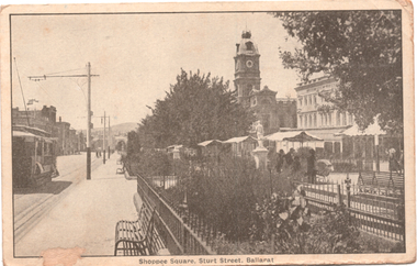 Ballarat Tramway Museum
Postcard, R.E.M Series Melbourne, "Shoppee Square Sturt Street Ballarat", c1915
... Photograph - looking east along Sturt Street between... Parade Ballarat Ballarat goldfields Photograph - looking east ...Photograph - looking east along Sturt Street between Doveton and Armstrong Streets, shows an ESCo tram eastbound. On the right is the Shoppee Square "market" place with awnings open. Wal Jack's note: "Part of the old type trams on the "up" track or north side of Sturt St from Doveton St. Date about 1914-16 period. Iron railings have long disappeared"Yields information about the streetscape of Sturt St and Lydiard Streets c1915.Postcard black and white, divided back, used, REM SeriesSee image 2 for Wal Jack's notes on the image. tramways, trams, esco, sturt st, shoppee's square -
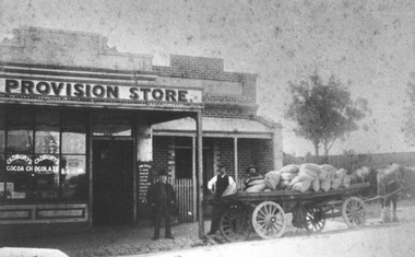 City of Ballarat Libraries
Photograph, Photos of the Anglin Family Grocery circa 1915
... Anglin Grocery was located in Eureka Street, Ballarat East... Street, Ballarat East. The photos show both Albert Anglin Senior ...Anglin Grocery was located in Eureka Street, Ballarat East. The photos show both Albert Anglin Senior and Junior, the delivery wagon loaded with bags of chaff, a gig used for deliveries with Anglin Grocery painted on the side and an advertisement for Cadbury Chocolate on the shop window.anglin grocery, albert anglin, eureka street, ballarat east, ballarat, commerical, cadbury chocolate -
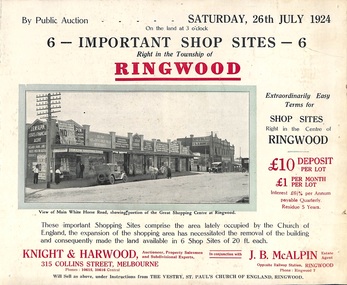 Ringwood and District Historical Society
Flyer, Shop Sites Sale By Public Auction, Ringwood, Victoria - 1924
... Locality plan highlights shop sites for auction east... sites for auction east of Pratt Street along Whitehorse Road ...Folded double-sided brochure advertising six Ringwood shop sites for sale by Public Auction at 3pm, Saturday, July, 1924, with town photographs, location map, and summary of local features and services. Includes newspaper extract from the Real Estate and Property section from "Evening Sun", 6th June, 1924.Locality plan highlights shop sites for auction east of Pratt Street along Whitehorse Road. (Agents) Knight & Harwood, 315 Collins Street, Melbourne, Phones 10615, 10616 Central, in conjunction with J.B. McAlpin, Estate Agent, Opposite Railway Station, Ringwood, Phone Ringwood 7. -
Inglewood & District Historical Society
Work on paper - Examination Certificate, The Pharmacy Board of Victoria Examination Certificate, 08/02/1922
... that Arthur James Jones of 6 Connor Street, East Geelong, has passed... Connor Street, East Geelong, has passed the final examination ...Arthur James Jones came to Inglewood in 1924 and commenced business as a chemist. He continued in this capacity until his retirement in June 1986 - retiring to live in his home at Verdon Street, Inglewood. During his time in Inglewood Arthur Jones held many positions in community life.Certificate of Practice allowing Arthur Jones to practice as a Chemist.Examnation Certificate on blue mount board mounted in dark stained wooden frame. White paper Certificate, black ink, with a red SealThe Pharmacy Board of Victoria do hereby Certify that Arthur James Jones of 6 Connor Street, East Geelong, has passed the final examination in Materia, Medica, Botany, Chemistry, and Practical Pharmacy and is a duly qualified Pharmaceutical Chemist under the Provisions of the Medical Act 1915 Part 3 arthur jones chemist inglewood -
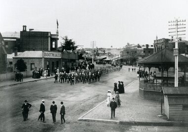 Stawell Historical Society Inc
Photograph, Bandsmen leading Senior and Junior Cadets in Main Street Stawell looking East from Memorial Area 1908
... Bandsmen leading Senior and Junior Cadets in Main Street... Street looking East from Memorial Area 1908. Boot makers shop... in Main Street looking East from Memorial Area 1908. Boot makers ...Parade of Bandsmen leading Senior and Junior Cadets in Main Street looking East from Memorial Area 1908. Boot makers shop between Town hall and Anglican Church on left Town Hall Hotel and shops on right with band rotunda to right of photo.stawell band pavillion boer war streetscape -
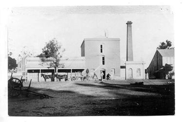 Tarnagulla History Archive
Photograph of Flour Mill complex, Tarnagulla, Flour Mill complex, Tarnagulla, circa 1882-1920
... the Flour Mill complex formerly situated on the south east corner... transport buildings commercial road main street Written on reverse ...Murray Comrie Collection. Information written by Murray Comrie: A meeting was called at the Golden Age Hotel on 11th June 1868 when it was resolved to build a flour mill. Thomas Comrie was the proprietor and was responsible for the Mill being built. Tenders were called by H.C. Bristol, in the Tarnagulla Courier of January 10, 1874, for the erection of the mill. Building of the Mill commenced in 1874. Pipes were laid to Company's Dam to obtain water for the Mill's boilers. Steam was got up for the first time on 30th March, 1882. A boiler burst about April 29th. Two men (J.H. Smith and W. Hargreaves) died as a result and two others were seriously injured. The mill commenced operations on 13th June 1882 with Mr. W. Fitzgerald as manager. The Mill operated with grinding stones until 1899 when new rollers and a considerable amount of new equipment was installed, including a new, more powerful engine to drive the Mill. In January 1901, 6,000 bags of wheat were received weekly and it was a common sight to see the streets lined with wagons. In 1913, 15,000 bags of wheat were bought at three shillings and four pence per bushell. In January 1914, wheat came in at the rate of 1500 bags a day with 20,000 bags in storage. Thomas Comrie died on 4th August 1910. The Mill was carried on by his executors, then closed for a short period prior to being sold in September 1918 to a Mr. O. Albert of Talbot. Albert operated the Mill for a few years but during the 1920s it was closed down and then pulled down. It was later re-erected at Mildura where it operated for many years. The far left section of the complex was originally John Pierce's Southern Cross General Store, a wholesale grocer and spirit merchant. It was put up for sale after Pierce's death in 1871, and later incorporated into the Mill complex. This is a poor copy of an older original. Copy probably made by Murray Comrie in the 1960s. Monochrome photograph of men, horses and a wagon outside the Flour Mill complex formerly situated on the south east corner of King Street and Commercial Road in Tarnagulla. At far left the Methodist church is partially visible in the background. At far right is part of the Mill's storage shed. Same image as THA-2019.0211Written on reverse: 'M. Comrie'tarnagulla, commerce, agriculture, food production, mill, milling, horses, transport, buildings, commercial road, main street -
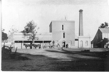 Tarnagulla History Archive
Photograph of Flour Mill complex, Tarnagulla, Flour Mill complex, Tarnagulla, circa 1882-1920
... the Flour Mill complex formerly situated on the south east corner... transport buildings commercial road main street Written on reverse ...Murray Comrie Collection. Information written by Murray Comrie: A meeting was called at the Golden Age Hotel on 11th June 1868 when it was resolved to build a flour mill. Thomas Comrie was the proprietor and was responsible for the Mill being built. Tenders were called by H.C. Bristol, in the Tarnagulla Courier of January 10, 1874, for the erection of the mill. Building of the Mill commenced in 1874. Pipes were laid to Company's Dam to obtain water for the Mill's boilers. Steam was got up for the first time on 30th March, 1882. A boiler burst about April 29th. Two men (J.H. Smith and W. Hargreaves) died as a result and two others were seriously injured. The mill commenced operations on 13th June 1882 with Mr. W. Fitzgerald as manager. The Mill operated with grinding stones until 1899 when new rollers and a considerable amount of new equipment was installed, including a new, more powerful engine to drive the Mill. In January 1901, 6,000 bags of wheat were received weekly and it was a common sight to see the streets lined with wagons. In 1913, 15,000 bags of wheat were bought at three shillings and four pence per bushell. In January 1914, wheat came in at the rate of 1500 bags a day with 20,000 bags in storage. Thomas Comrie died on 4th August 1910. The Mill was carried on by his executors, then closed for a short period prior to being sold in September 1918 to a Mr. O. Albert of Talbot. Albert operated the Mill for a few years but during the 1920s it was closed down and then pulled down. It was later re-erected at Mildura where it operated for many years. The far left section of the complex was originally John Pierce's Southern Cross General Store, a wholesale grocer and spirit merchant. It was put up for sale after Pierce's death in 1871, and later incorporated into the Mill complex. This is a reasonable copy of an older original. Copy probably made by Murray Comrie in the 1960s. Monochrome photograph of men, horses and a wagon outside the Flour Mill complex formerly situated on the south east corner of King Street and Commercial Road in Tarnagulla. At far left the Methodist church is partially visible in the background. At far right is part of the Mill's storage shed. Same image as THA-2019.0048Written on reverse: 'M. Comrie'tarnagulla, commerce, agriculture, food production, mill, milling, horses, transport, buildings, commercial road, main street -
Royal Australian and New Zealand College of Obstetricians & Gynaecologists (RANZCOG)
Sculpture - Beaver sculpture by Dr Ruth Walker, c.1980
... in Albert Street, East Melbourne. This piece was gifted to Dr Bob... in Albert Street, East Melbourne. This piece was gifted to Dr Bob ...Dr Ruth Walker was a member of the AMA Arts Group, which was founded in 1959. She contributed a number of pieces of sculpture to exhibitions during the 1980s. Copies of AMA exhibition catalogues are held by La Trobe University Library. Exhibitions were usually help in September-October at the Victorian Artists' Society in Albert Street, East Melbourne. This piece was gifted to Dr Bob Bennett, and donated to the College by his widow. Wooden sculpture of a stylised beaver, carved out of a single piece of huon pine. "R.WALKER" is engraved on the base of the sculpture."R.WALKER"sculpture -
 Bacchus Marsh & District Historical Society
Map, Maddingley Township, Parish of Parwan, County of Grant, 1856
... to the east of Franklin Street is not sub-divided and is described... to the east of Franklin Street is not sub-divided and is described ...Maddingley is a locality or township within the broader township area of Bacchus Marsh. This map is dated 1856 but is based on an earlier survey in 1843. The main area of Maddingley shown on this map is an area bounded by Bacchus Street, Moore Street, Griffith Street and Franklin Street. Other streets visible are Inglis Street, Labilliere Street, McCrae Street. The area to the east of Franklin Street is not sub-divided and is described as an 'alluvial flat. A single page paper map showing land allotments, streets, and natural watercourses in the township of Maddingley. The map is pasted into a bound volume containing 76 maps or plans in total. Two inscriptions: 1. A.J. Skene Surveyor, 1843. ; 2. Surveyor-General's Office Melbourne, Sept 6, 1856. (Lithographed by R. Meikle)bacchus marsh victoria maps, maddingley victoria maps, land use, maddingley victoria history -
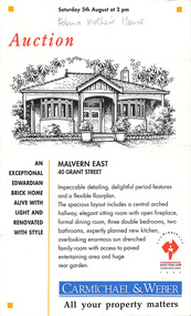 Robin Boyd Foundation
Pamphlet, Real estate, 1995
... Carmichael & Weber, Auction of 40 Grant Street Malvern East...Robin Boyd Foundation 290 Walsh Street South Yarra ...Carmichael & Weber, Auction of 40 Grant Street Malvern East, on 5th August 1995. Edith Boyd, Robin Boyd's mother, purchased this house in 1927 and called it Burdes. Edith Boyd later moved to East Burwood where she died on 31 March 1961.Robin's mother's house in pencil on the top. -
 Surrey Hills Historical Society Collection
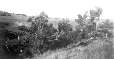
Photograph, View from Goodwood Street, Surrey Hills in 1930, 1930
... Black and white photo taken from the east end of Goodwood... from the east end of Goodwood Street, Surrey Hills in 1930 ...The Breeden family came to Surrey Hills in 1905, first to Guildford Road, then Middlesex Road where Horrie Breeden lived as a boy. He sometimes used to help with milking at the adjoining Kenneally's dairy in Highfield Road. Sometimes he and his brother drove the cows from there to Schneider's property near Florence Road on the way to Surrey Hills Primary School. The cows would graze here until the boys took them back after school. At other times he would deliver milk from the Croydon Road dairy (Isherwood's or Bovill's) to St Joseph's Boys Home before school. Horrie became an apprentice in woodwork / carpentry at Vine's timber yard before serving in World War 1. Horrie's father died in 1919 and in the same year he bought 3 cows and established his own dairy on his mother's property on the corner of Goodwood Street and Boisdale Road. In the 1920s Horrie built the first house in Goodwood Street. He went on to build others in the street including his own at No 7 Goodwood Street. He did all the joinery and internal fittings for this. [REF: Oral testimony: Horrie Breeden to Jocelyn Hall in 1979.] In the 1990s the owner of 7 Goodwood Street discovered a branding iron under the house; this is presumed to relate to Horrie Breeden's dairy. It was donated to SHNC's collection. Horrace Bruce Breeden (7 July 1898-24 January 1988) was son of Charles Henry Breeden and Lavinia Maria Darby, both born Warwickshire; buried in Box Hill Cemetery. He was one of a large family. He married Olive Mary Romey.Black and white photo taken from the east end of Goodwood Street, Surrey Hills in 1930, looking towards Elgar and Riversdale Roads. It shows an area which is rural in appearance. It is not built upon. The foreground is grassy and there is a post-and-wire fence to the right. There is a bank of eucalyptus trees behind which is hilly grassland.goodwood street, dairies, horace breeden, horrie breeden -
 Melbourne Tram Museum
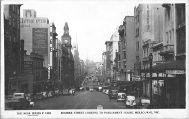
Postcard, Rose Stereograph Co, "Bourke Street looking to Parliament House, Melbourne", c1939
... Rose Series postcard No. P 3589, titled "Bourke Street... to Parliament House, Melbourne". The photo looks east from Queen Street ...Rose Series postcard No. P 3589, titled "Bourke Street looking to Parliament House, Melbourne". The photo looks east from Queen Street. There are several cable trams in the view. Has signs for Gibson, the Victoria Hotel, Osram lamps and valves, BGE, Myer, Foys, Danks, Thomas Evans, Donald Macintosh gun maker, and the Evans House, The Commercial Bank of Australia. See item 8071 for a similar image.Yields information about Bourke St c1939.Postcard - printed real photograph with Rose Stereograph Co. name on the rear.trams, tramways, cable trams, bourke st -
 Port Melbourne Historical & Preservation Society
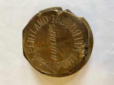
Machine - W & A PENTLAND Wheel Hub, c.1950
... between Ingles & Raglan Streets on the east side of Crockford... & Raglan Streets on the east side of Crockford Street. As well ...William PENTLAND arrived in Sandrisge in 1864 and set up his own coach building business in 1880.The firm was located between Ingles & Raglan Streets on the east side of Crockford Street. As well as coach building - and later motor body building - the firm were wheelwrights and blacksmiths.Round brass wheel hub cap from W & A PENTLAND, Port MelbourneW & A Pentland Port Melbourne Buildersw & a pentland, business & traders - manufacturing, william pentland -
 Robin Boyd Foundation
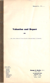
Document, George L Steele, Sworn Valuer, Valuation and Report, 14.04.1961
... east corner of Tiller Street and Burwood Road, East Burwood... at the south east corner of Tiller Street and Burwood Road, East ...This is a valuation and report on the property at the south east corner of Tiller Street and Burwood Road, East Burwood, as part of the estate of Mrs Edith Boyd, the mother of Robin Boyd. This was commissioned by John Penleigh (Pat) Boyd, Robin Boyd's brother. Edith Boyd died on 31 March 1961.Two page document plus a small black and white photograph in a thick paper folder. -
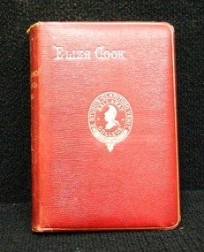 Ballarat Clarendon College
Book, Eliza Cook, The poetical works of Eliza Cook, Prior to the book prize given at Christmas, 1891
... is John S McGowan and the residence as 11 Ebden(?) Street...Ballarat Clarendon College 1425 Sturt Street Ballarat ...This book was awarded to John Geddes McGowan in 1891 for first prize in Latin. John entered the college in January of 1891 at the age of 13. He was the dux of Ballarat College in 1892. It is noted in the original register that John's parent is John S McGowan and the residence as 11 Ebden(?) Street, Ballarat East.Presbyterian educators placed great value on a classical education matched with diligence in study. Book prizes were highly regarded and academic success admired. In the school’s early years prizes were ordered direct from London and had the school crest embossed in gold on the front or back cover. Many of the prizes given in early years were returned to the school to equip the Weatherly Library when it opened in 1936.Bound in red calf with college emblem embossed on front cover and gilt bordering. Floral end papers, foxing on pages, red/gilt edges, black and white illustrations throughout. 624 p.Book plate inside front cover: Ballarat College emblem/ Latin/ IV Form./ First Prize./ Awarded to/ J.G.McGowan/ Christmas, 1891/john-geddes-mcgowan, 1891, book-prize, dux-1892, john-s-mcgowan. -
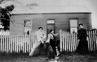 City of Kingston
Photograph - Black and white, c. 1910
... Street in East Bentleigh. It was owned by Caleb Porter... Street in East Bentleigh. It was owned by Caleb Porter ...The cottage was located on East Boundary Road, near Caleb Street in East Bentleigh. It was owned by Caleb Porter and occupied by Laura Johnson (centre). Also in the photograph are her sister Boletta Hansen Wold (left) and daughter Anna Marie Johnson (right). The dog's name has not been recordedPart of East Bentleigh was inside the original grant of land bought by English farmer and brewer, Henry Dendy, in 1841. He bought 5,120 acres (20.7 km2) which was bounded on the west by Port Phillip Bay, then North Road, East Boundary Road and South Road.Black and white image of three women and a dog standing outside a small weatherboard cottage with a picket fence. Round white sticker with black printed text: 140 Handwritten in red ink: 55%east bentleigh, caleb porter, laura johnson, boletta hansen wold, anna marie johnson -
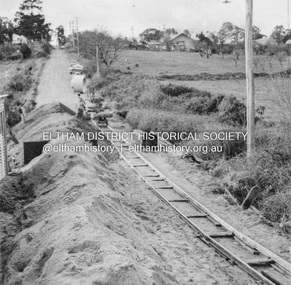
 Eltham District Historical Society Inc
Slide, Pryor Street, Eltham, 25 Jul 1973
... Looking east across Pryor Street towards the Eltham Police... melbourne Looking east across Pryor Street towards the Eltham Police ...Looking east across Pryor Street towards the Eltham Police Station. The Police purchased the residence at 23 Pryor Street in 1959 to move from the old town centre of the late 1800s to be closer to the new town centre that shifted as a result of the railway opening in 1901. The residential house was renovated to Police requirements and operations commenced from this location in 1961. Diretly opposite and to the left of the Police Station is now a busy shopping centre car park.35 mm colour positive transparency Mount - Agfacolor Service (Blue)eltham, eltham police station, pryor street, streets, houses -
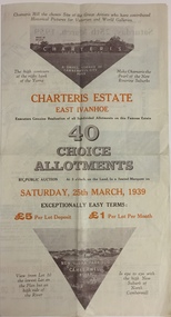 Kew Historical Society Inc
Plan - Subdivision Plan, Charteris Estate, East Ivanhoe, 1939
... Four-fold brochure advertising the Charteris Estate in East... includes lots in the Government Boulevard, Castella Street ...The Charteris Estate in Ivanhoe was sold in a number of sections. Copies of a subdivision plan of the first section is in the State Library of Victoria collection. This later section of the Charteris Estate includes lots in the Government Boulevard, Castella Street, McArthur Road, Burke Road North, Charteris Drive and Warncliff Road.Subdivision plans like that for the Charteris Estate are invaluable records for local historians identifying when lots in streets were promoted for sale.Four-fold brochure advertising the Charteris Estate in East Ivanhoe in 1939. Streets named on the plan include: the Government Boulevard, Castella Street, McArthur Road, Burke Road North, Charteris Drive and Warncliff Road. The brochure contains photos of Charterisville, the home of F De Castella Esq and also of attractive rolling hills. Annotations in pencilcharteris estate - east ivanhoe (vic), subdivision plans - east ivanhoe (vic) -
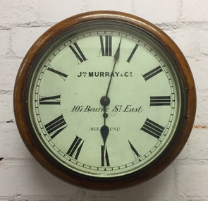 Kew Historical Society Inc
Functional object, Jas Murray & Co, Wall Clock & Key, 1860s
... Street East, Melbourne by Francis Barnard. James Murray & Co were... & Co’ is painted above the centre, with ‘107 Bourke Street East..., with ‘107 Bourke Street East’ and ‘Melbourne’ below, with the key ...The clock was purchased from Jas Murray & Co. of 107 Bourke Street East, Melbourne by Francis Barnard. James Murray & Co were well known clock and watchmakers operating from premises in London with branches in Calcutta and Melbourne. They were watchmakers and jewellers in Melbourne from 1860 to 1888. Francis Barnard established Barnard’s Pharmacy on the corner of Bulleen Road (later renamed High Street) and Cotham Road in 1857. In the early 1860s, after purchasing the clock, he placed it in his pharmacy where it could be seen by passers by. When he relocated across the road to 49 Bulleen Road (now 167 High St.) in 1880 he took the clock to the new premises. He maintained the accuracy of the clock so that local residents consulted it for the correct time, even after the Post Office building with its clock tower was opened in 1888. When Francis Barnard retired, his son took over the pharmacy. In 1925, the Barnard Pharmacy was sold to David Paton. The Paton’s were at first puzzled why people constantly peered in the door until they realised that the timepiece was the drawcard. When David Paton died in 1941, his widow sold the pharmacy but took the clock with her to her new florist shop at 145 High Street. When Mrs Paton retired in 1953, she took the clock to her home in Boronia. In 1973 her daughter donated the clock to the Kew Historical Society.Significant locally to Kew as an example of a timepiece that was used by the local community during the 19th century to tell the time.Barnard’s clock is a typical wall clock of the nineteenth century, variants of which could be seen in shops, offices, public buildings and stations. It has a mahogany case with a moulded wooden bezel encasing a hinged brass bezel housing the glass face which protects the dial and hands when working. The clock face has an off-white hand painted tin dial with black painted Roman numerals. The hands are black painted metal; the hour hand has a wide spade shaped point whilst the minute hand is much thinner. ‘Jas Murray & Co’ is painted above the centre, with ‘107 Bourke Street East’ and ‘Melbourne’ below, with the key hole in between. The clock movement is a fuse chain attached to a brass mainspring barrel which powers the pendulum for eight days. This is housed within a rectangular wooden casing with a convex curved base housing a hinged door giving access to the pendulum which is attached to the back of the clock by four wooden pegs.Jas Murray & Co / 107 Bourke St East / Melbournefrancis barnard, f g a barnard, high street - kew (vic), pharmacies - kew (vic), clocks, paton's pharmacy --- kew (vic.), bulleen road -- kew (vic.) -
 Eltham District Historical Society Inc
Negative - Photograph, J.A. McDonald, Newly built home, Sep. 1955
... ) indicating street runs east west direction and camera view...) indicating street runs east west direction and camera view ...Street and location unidentified, possibly not Eltham though next immediate frame is Pryor Street and sun position appears to be similar indicating street (ealrly to mid afternoon) indicating street runs east west direction and camera view is to the south. Streets in Eltham are all even numbered on the south sideRecord of various Shire of Eltham infrastructure works undertaken during the period of 1952-1962 involving bridge and road reconstruction projects, sometimes with Eltham Shire Council Project Reference numbers quoted. It was during this period that a number of significant improvements were made to roads and new bridges constructed within the shire that remain in place as of present day (2022). In many situations, the photos provide a tangible visible record of infrastructure that existed throughout the early days of the Shire. The album was put together by or under the direction of the Shire Engineer, J.A. McDonald.1955-09, houses, shire of eltham -
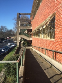 Federation University Historical Collection
Photograph - black and white, Clare Gervasoni, Ballarat School of Mines M.B. John Buildings, 2016, 08/09/2016
... framed, round‐arched entrance and stair wells on the east (Albert... entrance and stair wells on the east (Albert Street) elevation ...The M.B. John Building (Building K), a three storey, face red brick, restrained Late Twentieth Century International styled building with an elongated, cuboid form (defined by the parapeted facades) that is offset by projecting exposed concrete framed, round‐arched entrance and stair wells on the east (Albert Street) elevation (the centrally located entrance breaking the brick façade with glazing). The facades are also characterised by banks of aluminium framed, horizontal ribbon windows, which wrap around the building corners. Metal shades project beyond the windows, while post‐supported bullnosed verandahs and hoods and projecting concrete stairs are other features. On the west elevation, the cuboid façade is punctuated by projecting curved concrete and glazed, elongated bays at first floor level. (David Rowe/Wendy Jacobs)Colour photograph of a red brick building on Albert Street. It was build to house trade workshops and Ceramics at the Ballarat School of Mines. m.b. john, m.b. john building, ballarat school of mines -
Coal Creek Community Park & Museum
Bottle, glass, Between 1872-1916 ref: bottle manufacturers mark
... Collins Street, East.' source TROVE. Also at 228 Collins Street... Collins Street, East.' source TROVE. Also at 228 Collins Street ...Advertisement. 'The Argus' newspaper (Melbourne, Victoria 1848-1957) Saturday 4 November 1882, page 8. 'Simpson & Davenport Pharmaceutical Chemists, (14 years with Mr. W. Bowen, successors to Mr. John Ross, formerly the business of Mr. R Hill, 63 Collins Street, East.' source TROVE. Also at 228 Collins Street, Melbouren at some date ref: cream pot lids with Simpson & Davenport Chemists advertisement, offered for auction.Rectangular pale blue tinted clear glass bottle with angled corners. Embossed text on one side and base.'SIMPSON & DAVENPORT CHEMISTS MELBOURNE' on side. 'M' on base. -
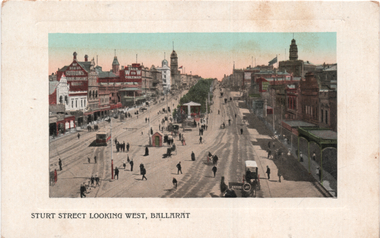 Ballarat Tramway Museum
Postcard, "Sturt Street looking west, Ballarat", c1906
... Photograph - looking east along Sturt Street from Grenville... Parade Ballarat Ballarat goldfields Photograph - looking east ...Photograph - looking east along Sturt Street from Grenville St showing the various buildings on both sides of Sturt St. One ESCo tram in the view along with many people and one horse-drawn vehicle. The photo was taken before the construction of the large office/waiting room shelter at the tram terminus - possibly c1906. This photo is used in item 2688 - same image but more defined colours within a gold background flowery oval.Yields information about the streetscape of Sturt St.Postcard coloured, divided back, unused, Valentine & Sons.Has marking "55393 JV" along the bottom edge. tramways, trams, esco, sturt st