Showing 1838 items
matching inches
-
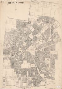 Ringwood and District Historical Society
Map, City of Ringwood - Rateable Properties Layout - c.1966
A0-size (approx) map of named streets, lot-numbered properties and locality features within City of Ringwood boundary. Scale: 8 chains to 1 inch. City Engineer's signature in bottom right corner - Alan Robertson (City Engineer 1958-1987) -
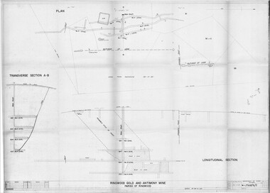 Ringwood and District Historical Society
Plan - Department of Mines, Victoria, Ringwood Gold and Antimony Mine - 1921
Technical drawings of Antimony Mine - Plan view, Transverse Section view, and Longitudinal Section view. Includes Main Shaft, No.1 Level 184', No.2 Level 244', No.3 Level 304', No.4 Level 372'. Multiple copies, including copy with overlay of Civic Centre.Scale 40 feet to 1 inch. Surveyed 20-12-21. Traced 1-7-66. W-2568/B/1. -
 Ringwood and District Historical Society
Map - State Aerial Survey, Dandenong Ranges Area, Parts of Parishes of Nunawading, Warrandyte and Ringwood - 1956
Map of Ringwood North and parts of Mitcham, Donvale, Park Orchards and Ringwood East compiled by Dept of Lands and Survey, July 1956, from aerial photographs and Cadastral Survey information. Sheet 1, Ringwood A2D or 849 A2D Zone 7. Scale: 4 chains to 1 inch. Contour interval 20 feet. -
 Clunes Museum
Drawing - DRAWINGS, UNKNOWN
FITTINGS PROPOSED FOR WATER SUPPLY TO CLUNES, VICTORIA, AUSTRALIAWORKING DRAWINGS IN PEN AND INK ON PAPER OF PIPE FITTINGSON FRONT: CLUNES WATER SUPPLY, DRAWING 1, CONTRACT 1, STRAIGHT PIPES AND IRREGULAR CASTINGS AS ARRANGED FOR SCHEME WITH 21 INCH MAINclunes water supply, technical drawings -
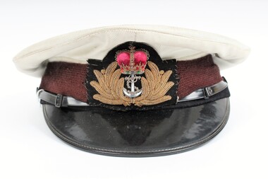 Ringwood RSL Sub-Branch
Memorabilia - Headgear, Hills Hats PTY. LTD, Naval Cap, 1981
White Cap, black rimmmed with gold laurel containing crown and anchor.Halls hats pty ltd Sydney 1981. RAN No. Name and “Made in NewZealand”; and indicates 6 and 7/8 inches hat size.ran, royal australian navy, naval headgear, navy cap -
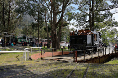 Puffing Billy Railway
Narrow Gauge Turntable ex 5'3" gauge newport
This Victorian railways constructed turntable is used for turning around locomotives. It is 16.2 meters long and is hand pushed either direction. Originally broad gauge (5 foot 3 inches) and located in the Newport Locomotive workshop area it was relocated to emerald and 2-foot 6-inch railway track fitted to it and is used by the Puffing Billy Railway to turn their locomotives and carriages Historic - Victorian Railways - Turntable used at Newport Narrow Gauge Turntable made of metal and steelturntable, victorian railways, puffing billy, emerald, newport -
Clunes Museum
Map, Township of Clunes - Parish of Clunes - County of Talbot
Map of Clunes Township in 19511 X PHOTOCOPY OF MAP, (COMPRISING A NUMBER OF A4 SHEETS TAPED TOGETHER) SHOWING LOT NUMBERS AND NAMES OF LANDHOLDER. REFERENCE GAZ 1951.1480. SCALE 30 CHAINS = 1 INCH 1 X PHOTOCOPY OF MAP, (COMPRISING A NUMBER OF A4 SHEETS TAPED TOGETHER) SHOWING LOT NUMBERS AND NAMES OF LANDHOLDER. REFERENCE: G76359 GENERAL FILE TOWNSHIP RESIDENTIAL ALLOTMENTS SCALE 30 CHAINS = 1 INCHNOTATED IN PURPLE CRAYON ON SECOND MAP: AS AT LATE 1984 COPY OF MAP FROM LAND TITLES OFFICE BALLARATtownship of clunes map, 1951 -
 Bendigo Historical Society Inc.
Map - HUSTLER'S REEF & HUSTLER'S REEF NO 1 MINES - PLAN OF THE HUSTLER'S REEF & HUSTLER'S REEF NO 1 MINES
Plan of the Hustler's Reef & Hustler's Reef No 1 Mines on the Hustler's Line of Reefs, Bendigo Bulletin No 33, Plate No XVI. Plan shows the two shafts and the levels in relation to it. No 9 Level 896 feet 9 inches connecting No 10 Level at 867 feet 2 inches. Plan shows depth of levels and geographical features. Signed by H A Whitelaw, Underground Survey Office, Bendigo. Geographical Survey of Victoria emblem.mining, parish map, hustler's reef & hustler's reef no 1 mines, hustler's line of reefs, h a whitelaw, underground survey office bendigo, geographical survey of victoria -
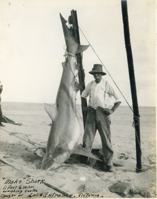 Lakes Entrance Historical Society
Photograph, 1930 c
Mako shark 11 ft 6 inch long, weighing 540 pounds, caught at Lakes Entrance, VictoriaBlack and white photograph of a mako shark on display on entrance pier, man standing beside shark. Lakes Entrance Victoriafishing, people -
 Ballan Shire Historical Society
Map - Map. Moorarbool East and West, Country Lands in the Parishes of Moorarbool East and Moorarbool West. Counties of Bourke and Grant
This is a map of "Country Lands" around the Werribee River, north of Ballan in the Counties of Bourke and Grant.A relatively small map, paper on a material backing. Shows topographical features, roads and property divisions. Scale of forty chains to one inch. The map is dated March 31st, 1859.There is a small inscription under the chain scale that reads "No 58/364 John Phillips ? Survey 1st August 1858". The name Dugald McPherson is hand written on one of the blocks of land.moorarbool west, moorarbool east, dugald mcpherson, county of bourke, county of grant, werribee river, ballan -
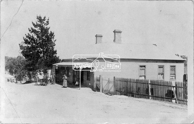 Eltham District Historical Society Inc
Negative - Photograph, West's Research Hotel, Main Road, Research, c.1910
Photo shows Tom Scarce and pony that won 1st Prize over jumps, ridden by jockey Jimmy Johnson against his own horse in the same race (Diamond Creek Show). Tom remembered Mrs Thornton and Bert Frim(?) Built by William West, the hotel destroyed by fire Sunday, 15 March 1931This photo forms part of a collection of photographs gathered by the Shire of Eltham for their centenary project book,"Pioneers and Painters: 100 years of the Shire of Eltham" by Alan Marshall (1971). The collection of over 500 images is held in partnership between Eltham District Historical Society and Yarra Plenty Regional Library (Eltham Library) and is now formally known as the 'The Shire of Eltham Pioneers Photograph Collection.' It is significant in being the first community sourced collection representing the places and people of the Shire's first one hundred years.Digital image 4 x 5 inch B&W Neg B&W Print 20 x25 cm B&W Print 9 x 14 cmPrint originally inscribed Kangaroo Ground hotel but crossed out and replaced with Research Hotel 1910 From Mr T. Scarse c/o Mrs T.M. Jones "Coolibah" Cherry Tree Rd Panton Hill M59bert frim, diamond creek show, hotels, jimmy johnson, jockey, mrs thornton, research (vic.), research hotel, sepp, shire of eltham pioneers photograph collection, tom scarce -
 Flagstaff Hill Maritime Museum and Village
Blackboard pointer, J Rabone and Sons
Blackboard pointer, wood cylindrical rod with brass tips at either end. Marked "J Rabone and Sons, Makers, Birmingham" and "Yard" on the brass tip. Calibrated in inches and fractions of a yard.flagstaff hill, warrnambool, shipwrecked-coast, flagstaff-hill, flagstaff-hill-maritime-museum, maritime-museum, shipwreck-coast, flagstaff-hill-maritime-village, blackboard pointer, j rabone and sons -
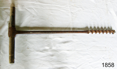 Flagstaff Hill Maritime Museum and Village
Auger
Ring Auger, Double Twist with Lead Screw and Curved Cutting Lips, 1 1/2 inch with wooden handle 666mmL made by A Mathieson Glasgow. Marked H on shaftflagstaff hill, warrnambool, shipwrecked-coast, flagstaff-hill, flagstaff-hill-maritime-museum, maritime-museum, shipwreck-coast, flagstaff-hill-maritime-village, ring auger, auger -
Bendigo Historical Society Inc.
Map - CAMPBELL COLLECTION: BENDIGO & DISTRICT MAPS
Map. Bendigo Whipstick, Scale 40 chains to 1 inch, Forests Commission Victoria, map N0.3, legend for roads and land and forest. (number 371 in map cupboard 1)map, bendigo, country lands -
Bendigo Historical Society Inc.
Document - SOUTH VIRGINIA MINE - LONGITUDINAL AND TRANS SECTIONS OF THE SOUTH VIRGINIA MINE
Handwritten and drawn longitudinal and trans sections of the South Virginia Mine. Both drawings have measurements in feet and inches. Gives measurements of poppet legs, buildings and part of mullock heap.document, gold, south virginia mine, south virginia mine, longitudinal and trans sections of the south virginia mine, m d a a 1, a e k, w r n 2/4/37 page 31, a e k & w r n 2/4/37 page 32 -
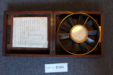 Coal Creek Community Park & Museum
Anemometer and case, Approxamitly June 29th, 1909
Calibration tests were made June 29th, 1909, all else is unknown.8386.1 - Biram's anemometer, 6 inch diameter, 5 dials, ten blades. "No. 1544," with wooden case and hand written note detailing applicable corrections after calibration tests. -
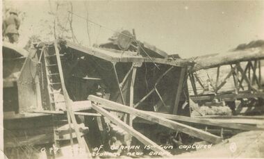 Bendigo Historical Society Inc.
Postcard - ACC LOCK COLLECTION: SITE OF GERMAN 15IN GUN CAPTURED BY AUSTRALIANS NEAR CAPPY, POSTCARD, 1914-1918
Postcard, WW1, B&W image of the remains of a 15 inch German gun captyerd by Australians near Cappy. Soldier standing on top of remains at top left. Copy G49postcard, postcard, ww1, 15 inch german gun, cappy, france -
 Whitehorse Historical Society Inc.
Swagger Stick
Items from Mitcham RSL CollectionSwagger Stick length 70cm (27.5 inch) with 1.10cm Britannia Metal end with embossed badge: Australian Commonwealth Military Forces and 1.10cm Britannia Metal band at other end.Australian Commonwealth Forcemilitary history, army -
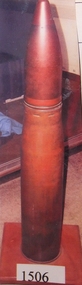 Stawell Historical Society Inc
Memorabilia - Realia, 1944
4 inch H.M.A.S. Stawell Shell Case was first fired in action and was used in the bombardment of the Japanese installations Kar Kar Island North New Guinea 12th May 1944stawell, ww2, navy -
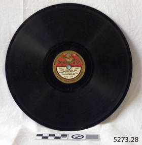
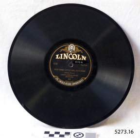 Flagstaff Hill Maritime Museum and Village
Audio - Gramophone Record
Bakelite record by The Lincoln Record Corporation N.Y. 2516 "Stay Home Little Girl, Stay Home" by Johnny Johnson and his Orchestra. No. 797 Size: 10 inch recordflagstaff hill, warrnambool, shipwrecked-coast, flagstaff-hill, flagstaff-hill-maritime-museum, maritime-museum, shipwreck-coast, flagstaff-hill-maritime-village -
 Flagstaff Hill Maritime Museum and Village
Audio - Gramophone Record
Bakelite record, Electrically Recorded, The Long Playing Record Broadcast A184 "Just Another Day Wasted Away" by Harry Bidgood and his Broadcasters. Size: 8 inch record.flagstaff hill, warrnambool, shipwrecked-coast, flagstaff-hill, flagstaff-hill-maritime-museum, maritime-museum, shipwreck-coast, flagstaff-hill-maritime-village -
Lakes Entrance Historical Society
Memorabilia - Cup, Junior Miss Henley Cup 1962, 1962
Social Historysilver plate cup approx 15 inches high - brown bakelite base. Presented to Linda Bereridge for Junior Miss Henley 1962 - won by Linda Noden nee Beveridgetrophy -
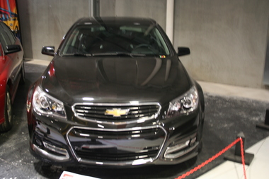 Trafalgar Holden Museum
Vehicle - 2017 VF .Chevrolet SS, 2017
This car is, to all extent, a VF Commodore, but built for the left hand drive market, i.e. The United States. It is an SS, having all the high performance features and safety upgrades of the period, and has an ANCAP 5 star safety ratingBuilt by Holden for the left hand drive marketBlack bodied 4 door sedan with sunroof. 19 inch alloy wheels grille in bonnet with extra grille mounted in bumper along with for lamps. Wind deflector on boot lidChevrolet badge both grille and boot lid centre. SS on boot right hand side.l.h.d., vehicle, chevrolet -
4th/19th Prince of Wales's Light Horse Regiment Unit History Room
Medal, King George VI Coronation Medal
The King George VI Coronation Medal was a commemorative medal made to celebrate the coronation of King George VI and Queen Elizabeth. For Coronation and Jubilee medals, the practice up until 1977 was that United Kingdom authorities decided on a total number to be produced, then allocated a proportion to each of the Commonwealth countries and Crown dependencies and possessions. The award of the medals was then at the discretion of the local government authority, who were free to decide who got a medal and why. A total of 90,279 medals were issued, including 6,887 to Australians 10,089 to CanadiansObject is a miniature. Description of full size medal: A circular, silver medal, 1.25 inches in diameter. Featured on the obverse are the conjoined effigies of King George VI and Queen Elizabeth, crowned and robed, facing left. The rim is not raised on this medal and there is no legend. The Royal Cypher GRI appears on the reverse, surmounted by a large crown, with the inscription CROWNED / 12 May 1937 below the Royal Cypher in tow lines. Around the rim of the medal is the inscription: GEORGE VI QVEEN ELIZABETH (a V in Queen rather than a U). The garter-blue ribbon is 1.25 inches (32 mm) wide; with a narrow (0.25 inch) band consisting of three equal widths of white, red, and white, at each edge.nil -
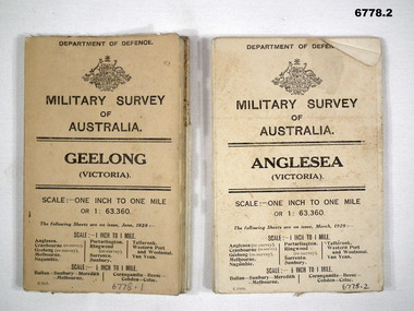 Bendigo Military Museum
Map - MAPS, GEELONG & ANGLESEA, 1928 - 1929
J.W. Swatton, Refer to Cat 6719.2P1. Military Survey map of Australia - Geelong, Vic. One inch to One mile - the map is in colour print. The two outer covers are cardboard, the map then opens up in a multifold manner. Date June 1928 2. Military Survey map of Australia - Anglesea, Vic. One inch to one mile - the map is in colour print. The two outer covers are cardboard. The map then opens up in a multi fold manner. Date March 1929.anglesea, military survey maps, geelong, victoria, passchendaele barracks trust -
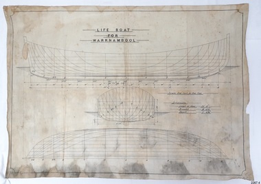 Flagstaff Hill Maritime Museum and Village
Plan - Vessel Line Drawing, Life Boat for Warrnambool, ca. 1900-1909
The plans were used for the construction of the lifeboat ‘Warrnambool’, which began 15th September 1909 and was completed almost 12 months later 1st September 1910. It was built at the Government Dockyard in Williamstown, Victoria, along the lines designed by Great Britain’s Royal Lifeboat Institution, and included whaleback decks fore and aft, mast and centreboard, and rudder and tiller hung from the sternpost. It could be propelled by both sail and oar. At that time Captain Ferguson was Chief Harbour Master and Mr Beagley was the foreman boat builder. Mr Beagley built the lifeboat with his fellow workmen. The boat was described as “… a fine piece of workmanship and does credit to her builders and designers…” It had all the latest improvements in shape, disposition of weight and watertight compartments, and it had space for a large number of people in addition to the crew. It appears that 'H Meiers' whose signature was on the plaque that was found concealed in the hull, was involved with the building of the lifeboat. His signature and the dates of the start and finish of the boat’s construction are pencilled on the raw timber 'plaque' found in the hull in the early 1990s when the lifeboat was being restored. It is interesting that the ‘Melbourne Directory’ of 1911, published by Sands and MacDougal, lists McAuley and Meiers, boat builders, Nelson Place foreshore, between Pasco and Parker Streets, Williamstown, (Victorian Heritage Database, ‘Contextual History, Maritime Facilities’), It is quite possibly the business of the person whose name is inscribed on the lifeboat plaque. Flagstaff Hill’s documentation also mentions that the keel was laid at ‘Harry Myers, boat builders, Williamstown, Melbourne’ – the name ‘Myers’ can also be spelled ‘Meiers’, which could be the same person as the Meiers in “McAuley and Meiers” (as mentioned in genealogy lines of Myers). The new lifeboat, to be named ‘Warrnambool’ was brought to town by train and launched at the breakwater on 1st March 1911 using the Titan crane (the old lifeboat built in 1858, was then returned to Melbourne in 1911). This new lifeboat was stationed at Warrnambool in a shed located at the base of the Breakwater, adjacent to the slipway. A winch was used to bring it in and out of the water. The lifeboat ‘Warrnambool’ was similar in size to the old lifeboat but far superior in design, build and sea-going qualities such as greater manoeuvrability. The ‘self-righting, self-draining design was “practically non-capsizeable” and even if the boat overturned it would right itself to an even keel and the water would drain away. The hull was built of New Zealand Kauri, using double diagonal planking, laid in two layers at right angles, with a layer of canvas and red lead paint between the timbers to help seal the planking. It has “… plenty of freeboard area, high watertight spaces between the deck and bottom… through which pipes lead…” The backbone timbers were made of Jarrah. The lifeboat Warrnambool was one of several rescue boats used at Port Fairy and Warrnambool in the early 1900s. In late 1914 the Warrnambool lifeboat and crew were used to help find what was left of the tragic wreckage of the Antares and were able to discover the body of one of the crewmen, which they brought back to Warrnambool. Between 1951 and 1954 the lifeboat was manned under the guidance of Captain Carrington. He held lifeboat practice each month on a Sunday morning, to comply with the Ports and Harbour’s request that lifeboats be manned by a strong and competent crew, ready for action in case of emergency. In the early 1960’s it ended its service as a lifeboat and was used in Port Fairy as a barge to help dredge the Moyne River, bolted to the Port Fairy lifeboat. Flagstaff Hill obtained the Warrnambool in 1975. In 1984 it was on display at Flagstaff Hill Maritime Village, Warrnambool. On 23rd May 1990, she was lifted from the water and placed in a cradle for restoration. The name ‘WARRNAMBOOL could be seen faintly on the lifeboat before it was restored. It was during the restoration that Flagstaff Hill's boat builder discovered the 'plaque' inside the hull. A copy of the blueprint plans has the name “V.E.E. Gotch” printed on it. His advertisement in Footscray’s ‘Independent’ newspaper of Saturday 11th May 1901 states he is “Principal and Skilled member (Naval Architect) to the Court of Marine Inquiry of Victoria and holds classes for naval architectural drawing and arithmetic.” The line drawing is significant for its connection with the lifeboat WARRNAMBOOL. The lifeboat is very significant to local and state history for its use in the lifesaving rescues of seafarers, particularly in Lady Bay. It was part of the local rescue equipment. It gave a half-century of service to the local community as a lifesaving vessel, including its involvement in retrieving the body of a shipwrecked crew member of the ANTARES. Line drawing in black ink and pencil on rectangular parchment or waxed linen. Drawing has diagrams of three profiles of a vessel, with measurements and connecting pencil lines on the left quarter. The plan is for the lifeboat named “Warrnambool”, which was built in Melbourne and completed in 1910. Old blue copies of the Lifeboat plan are archived also.“LIFE BOAT / FOR / WARRNAMBOOL” “Scale, One Inch to One Foot” “ “Length as shown 30’ – 8” “ “Breadth “ “ 8’ – 6 ½ “ “ “Depth “ “ 3’ – 4 ¾” “flagstaff hill, warrnambool, shipwrecked-coast, flagstaff-hill, flagstaff-hill-maritime-museum, maritime-museum, shipwreck-coast, flagstaff-hill-maritime-village, lifeboat, warrnambool lifeboat, boat plans, lifeboat plans, boat construction, boat building, line drawing, plan for lifeboat, life boat, life boat 'warrnambool', clinker design, 1910 lifeboat, life saving equipment, shipbuilding -
Clunes Museum
Domestic object - GRIDDLE
CAME OUT FROM SCOTLAND IN 1851LARGE DISC SHAPED BASE WITH HANDLESTICKER MARKED "GRIDDLE - CAME OUT FROM SCOTLAND 1881 - (LOANED J. McKENZIE)" MARKING UNDER BASE "CANNON - 18 INCH 785"local history, domestic item, cooking, domestic items -
 Flagstaff Hill Maritime Museum and Village
Map - Survey Map, F.F. McGovern, Yangery - County of Villiers, 1884
A surveyor was employed to measure the land designated as Yangery, County of Villiers, in the Borough of Warrnambool. The area on the map is similar to the earlier Farnham Survey undertaken by William Rutledge in the 1850's. Warrnambool was a Borough between 1863-1883. Coutours, waterways, sea and other significant points are shown. The distances are accurately measured. This survey map was used for planning future land sales, recreation areas and roads. WILLIAM RUTLEDGE (1806-1876) William Rutledge surveyed the land known as Farnham in southwest Victoria in 1843. His tenants made him a profitable business from working the land there. In 1863 Rutledge moved from nearby Port Fairy to Farnham and became very successful in breeding sheep, which he imported from J.R. Kirkham of Lincolnshire, England. He also bred horses on his land. The survey map of Yangery is important for its connection with renowned surveyor William Rutledge. The map shows the growth of landholders in the district when compared to the original Rutledge survey of the 1850's.Survey map of Yangery, titled "Yangery - County of Villiers". Printed on white paper, mounted on brown paper. c. 1863-1876. Comments printed on the Map include; Special Survey by William Rutledge, Photo-lithographed at the Department of Lands and Survey, Melbourne by W.J. Burson, Price 1/- [one shilling]. Scale is in Chains. Map has boundaries of Koroit Borough, Meerai, Purnim, Wangoom, Borough of Warrnambool, Mentions the Proposal of Tower HIll for Public Recreation. The map names the owners of the land at that time. Hand written pencil marks and figures and "Sauls fence" drawn on map. Hand written pencil markes and figures and "Sauls fence" drawn onto map. "For Department Use only". "Scale: 8 chains to 1 inch" flagstaff hill, warrnambool, shipwrecked-coast, flagstaff-hill, flagstaff-hill-maritime-museum, maritime-museum, shipwreck-coast, flagstaff-hill-maritime-village, county of villiers map, yangery district, w.j. burson, borough of warrnambool, koroit, purnim, meerai, wangoom, proposal of tower hill for public recreation, special survey by william rutledge, william rutledge, farnham, lincolnshire sheep, clydesdale -
 Eltham District Historical Society Inc
Photograph, Albert Jones, Photographer, c.1910
Photo supplied by B. Heddle reproduced on p137 of The Diamond Valley Story by Dianne H. Edwards, Shire of Diamond Valley 1979. "Albert Jones, photographer. Born in 1879, Albert Jones owned the property Golden Glen at Wattle Glen. He was an orchardist and a very busy photographer, travelling over the Diamond Valley area recording everyday events, street scenes, and visiting homes to take family groups. With the help of Claude Burrows, cousin of Mrs Arthur Jones, he built hides from which to photograph local bird life. His hundreds of glass negatives lay forgotten in the basement darkroom until A,J. Spark of Balwyn purchased Golden Glen from Albert Jones's widow in the 1970s. His unclassified negatives are gradually being sorted by Mr Spark. All photos in this book from the Spark/Jones Collection are the work of Albert Jones."Black and white copy of photo printed on glossy photographic paper 30.5 x 40.5 cm (12 x 16 inch); image size approx. 18.5 x 28 cmalbert jones, diamond valley story, golden glen, photographer, wattle glen -
 Eltham District Historical Society Inc
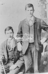
Photograph, William and Harold Sinclair of Diamond Creek, c.1895
Photo supplied by J. Sinclair reproduced (cropped) on p48 of The Diamond Valley Story by Dianne H. Edwards, Shire of Diamond Valley 1979. "Twin sons of Harry Sinclair who came to the district from Scotland in 1860." William and Harry were born 25 Feb 1869 in Diamond Creek. William died 12 Sep 1943 at Heidelberg and Harry died 1947 at GreensboroughBlack and white copy of photo printed on glossy photographic paper 30.5 x 40.5 cm (12 x 16 inch); image size approx. 18.5 x 28 cmdiamond creek, diamond valley story, harold sinclair, henry colling sinclair, henry sinclair, william alexander sinclair, william sinclair