Showing 831 items matching "land office"
-
 Bendigo Historical Society Inc.
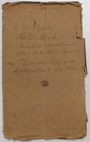
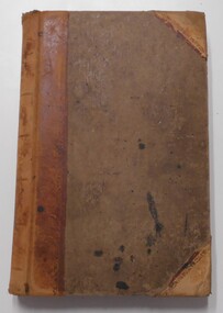
Document - LANDS OFFICE: SANDHURST CROWN LAND SOLD BY AUCTION 1854
... LANDS OFFICE: SANDHURST CROWN LAND SOLD BY AUCTION 1854...Document: LANDS OFFICE: SANDHURST CROWN LAND SOLD...Lands Office Bendigo Sandhurst land sales Lands Office ...Document: LANDS OFFICE: SANDHURST CROWN LAND SOLD BY AUCTION 1854 booklet - brown paper cover with blue pages. On front cover ' copy of sale books, town lots Sandhurst, April 18,19,20,21, 22 and 24 also suburban lots on the Bendigo Creek sold May 10TH.? 1854' Booklet contains copies of advertisement for auctions, written alongside, name of purchaser and amount paid per acre. White sticker fixed to pocket ' Book 1, Sandhurst Land Sales, 10 May 1854 to 18 May 1854Lands Officelands office, bendigo, sandhurst, land sales -
 Bendigo Historical Society Inc.
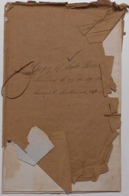
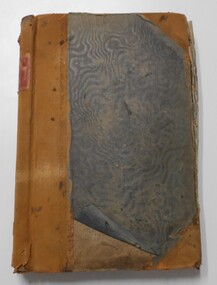
Document - LANDS OFFICE: SANDHURST AND DISTRICT CROWN LAND SOLD BY AUCTION 1854
Document: booklet, brown paper cover secured by string on spine. Written on front cover ' copy of sale books, January 16, 17. 18, 19, 26 1854. Harcourt, Lockwood, Muckleford' Blue lined pages with copy of advertisement for town lots for auction. LH page columns: price per acre, amount, deposit. RH page balance, purchaser, name, residence. White sticker fixed to pocket: Book 4 Sandhurst Land Sales, including outlying areas 16 January 1854 to 19 January 1854.lands office, bendigo, sandhurst, harcourt, muckleford, lockwood, land sales, auctions -
 Bendigo Historical Society Inc.
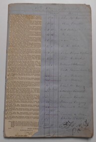
Document - LANDS OFFICE: SANDHURST AND DISTRICT LAND SALES BY PUBLIC AUCTION 1857, 1857 - 58
... LANDS OFFICE: SANDHURST AND DISTRICT LAND SALES BY PUBLIC...Bendigo Land Sales Document: blue lined pages listing crown ...Document: blue lined pages listing crown land auctions held in Sandhurst 1857/58. Book contains newspaper cutting listing town lots for sale. LH page: Total, balance, deposit, purchaser. LH page: same. White sticker fixed to front: Book 6 Sandhurst land Sales including outlying areas 30 January 1857 to 29 June 1859bendigo, land sales -
 Bendigo Historical Society Inc.
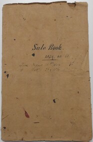
Document - LANDS OFFICE: SANDHURST AND DISTRICT LAND SALES BY PUBLIC AUCTION 1859 - 60
... LANDS OFFICE: SANDHURST AND DISTRICT LAND SALES BY PUBLIC...Bendigo land sales 1859 - 60 Lands Office Sandhurst crown ...Document: booklet, brown heavy paper cover bound secured with white cotton. Blue paper pages. On front cover ' Sale Book 1859, 60, 61. From August 16th. 1859 to Feb. 26 1861' Contains newspaper cuttings of crown land sales held in Sandhurst. Alongside cuttings are columns: price per acre, amount, purchasers. White sticker fixed to pocket: Book 7 Sandhurst Land Sales 16 August 1859 to March 1861Lands Officebendigo, land sales 1859 - 60, lands office, sandhurst, crown land, auctions -
 Eltham District Historical Society Inc
Document, Certificate of Consent of Sale of Lot 20 Henry Street, Eltham to Hope of Eltham Tent No. 195 Victoria District Independent Order of Rechabites, 28 Nov 1901
Alexander Robert Edgar, President of the Victoria and Tasmania Conference of the Wesleyan Methodist Church by Certificate of Consent of Sale dated 28 November 1901, declared that the Conference of the Church held in Melbourne, 27 February 1894, agreed to the sale by the Trustees of Lot 20 Henry Street. Indenture dated 15 November 1901 between Revd. Barnabas Shaw Walker, Minister of the Pentridge Circuit, Joseph Cooper, Gardener of Keelbundora, Samuel Jeffrey, Farmer of Jika Jika, John Brown, State School Teacher, Robert David Taylor, Gardener and Isaac Hill, Dealer, all of Eltham, the Trustees conveyed the land to William John Taylor the Younger, Gardener, George Knapman, Blacksmith and Isaac Hill junior, Carrier, all of Eltham and Trustees at the time for a Friendly Society known as the Hope of Eltham Tent No. 195 Victoria District Independent Order of Rechabites for the sum of £40. The conveyance was received into the Office of the Registrar General, State of Victoria, 12 December 1901. Originally purchased in 1856 from Thomas Roberts, Yeoman of Little Eltham, for £10 for use by the Wesleyan Chapel, represented by indentured Trustees, Rev. Barnabas Shaw Walker, Minister of the Pentridge Circuit, Francis Thomas, Farmer of Keelbundora, William Harriman, Blacksmith of Nillumbik, Nicholas Rodda, Farmer of Nillumbik, Aaron Grimshaw, Farmer of Greensborough, Joseph Cooper, Gardener of Keelbundora, Peter Dredge, Scholmaster of Jika Jika and Samuel Jeffrey, Farmer of Jika Jika. Lot 20 of Subdivision of Portion 13, Section 4 of the Parish of Nillumbik in the County of Evelyn was located on the southern side of Henry street in Little Eltham North, where the current Our Lady Help of Christians Catholic Church is situated. It became the location of the Eltham Rechabite Hall. In 1893 a new hall was built and further enlarged in 1919. At the commencement of 1922, the property was purchased from the Independent Order of Rechabites with publicly subscribed funds and a new hall built at a cost of £750 and improved road access constructed to reduce the grade, running from Dudley Street to Henry Street. This hall was eventually replaced with the new Shire Offices and Hall built on the corner of Arthur Street and Main Road, which was opened in 1941. Traces the earliest history of the Eltham Public Hall in Henry Street and the various names, occupations and abodes of the Trustees associated with the propertyaaron grimshaw, blacksmith, edmond perry, eltham public hall, eltham rechabite hall, eltham wesleyan chapel, francis thomas, george knapman, george smith, henry street, hope of eltham tent no. 195, i.w. lucas, isaac hill, james blanch, james chapman, james william brown, john brown, john jenkins peacock, john jones, john neale, john van mangerhoussen weiss, joseph cooper, joseph morris holloway, josiah atwool, keelbundora, lancelot iredale, little eltham, little eltham north, lizar elliott, mark blanchard, methodist church, nicholas rodda, p. mather, peter dredge, rev barnabas shaw walker, robert david taylor, samuel jeffrey, samuel moor munce, thomas roberts, thomas wheaten bowden, trustee, victoria district independent order of rechabites, wesleyan methodist church, william harriman, william hebblewhite, william john munce, william john taylor, william matthews, william rose -
 Ringwood and District Historical Society
Flyer, Land Sale Brochure, Heathmont Heights Estate, Heathmont, Vic. - 1959
Bi-fold advertisement for sale of residential sites, including map and summary of subdivision features and local facilities. Subdivision includes Coven Avenue, View Court, and Miller Road. Agent - A.W. Dickson, Opposite Station. (Phone) WU6007, WU7016, after hours WU6868. Accompanying Titles Office Plan of Subdivision photocopy dated 1971 - Part of Crown Allotment 38A Parish of Ringwood. -
 Eltham District Historical Society Inc
Newsletter, Newsletter, No. 5, March 1979
Contents: • Annual General Meeting • Early land sale documents • Recent activities • Recognition of pioneers and local people • Society speakers • Committee meeting The Shire of Eltham Historical Society was formed in October 1967. The first newsletter of the Society was issued May 1978 and has been published continuously ever since on a bi-monthly basis. With the cessation of the Shire of Eltham in late 1994, the Society's name was revised to Eltham District Historical Society and this name first appeared with issue No. 103, July 1995. The collection of the Society's newsletters provides a valuable resource on the history of the Society's activities, office bearers and committee members, guest speakers and subjects of historical interest pertinent to the former Shire of Eltham and the Eltham District.A4 photocopied newsletter distributed to membersnewsletter, eltham district historical society, shire of eltham historical society -
 Merbein District Historical Society
Document, Fishers Stores Documents, 1916-1926
fishers stores, british imperial oil company, petrol - motor spirit, g.t. kain - letter, crown land sale notice, transfer statement of post office (from fishers), transfer statement of post office equipment (from fishers), residents signatures -
 Eltham District Historical Society Inc
Document, Declaration of Trustees, Eltham Public Hall, Lot 20 Henry Street, Eltham, 18 Mar 1927
Robert David Taylor of Eltham declared he was the Secretary of a certain Friendly Society known as the Hope of Eltham Tent No. 195 Victoria District of the Independent Order of Rechabites; that William John Taylor the Younger, George Knapman and Isaac Hill junior the Purchasers mentioned and described in a certain Indenture of Conveyance from Barnabas Shaw Walker and others also therein described registered in the office of the Registrar General were at the time of the registration of the said Conveyance the trustees of the said Friendly Society and purchased the land and hereditaments described in the Conveyance as such Trustees; and that Edward Samuel McColl, Jack Alfred Harrison and William Wilson were on 31 December 1926 the trustees of the said Friendly Society and as such were entitled to grant and convey the land and hereditaments described in the said Indenture of Conveyance. Originally purchased in 1856 from Thomas Roberts, Yeoman of Little Eltham, for £10 for use by the Wesleyan Chapel, represented by indentured Trustees, Rev. Barnabas Shaw Walker, Minister of the Pentridge Circuit, Francis Thomas, Farmer of Keelbundora, William Harriman, Blacksmith of Nillumbik, Nicholas Rodda, Farmer of Nillumbik, Aaron Grimshaw, Farmer of Greensborough, Joseph Cooper, Gardener of Keelbundora, Peter Dredge, Scholmaster of Jika Jika and Samuel Jeffrey, Farmer of Jika Jika. Lot 20 of Subdivision of Portion 13, Section 4 of the Parish of Nillumbik in the County of Evelyn was located on the southern side of Henry street in Little Eltham North, where the current Our Lady Help of Christians Catholic Church is situated. It became the location of the Eltham Rechabite Hall. In 1893 a new hall was built and further enlarged in 1919. At the commencement of 1922, the property was purchased from the Independent Order of Rechabites with publicly subscribed funds and a new hall built at a cost of £750 and improved road access constructed to reduce the grade, running from Dudley Street to Henry Street. This hall was eventually replaced with the new Shire Offices and Hall built on the corner of Arthur Street and Main Road, which was opened in 1941. Traces the earliest history of the Eltham Public Hall in Henry Street and the various names, occupations and abodes of the Trustees associated with the propertyedward samuel mccoll, eltham public hall, eltham rechabite hall, eltham wesleyan chapel, george knapman, henry street, hope of eltham tent no. 195, isaac hill junior, jack alfred harrison, trustee, victoria district independent order of rechabites, william john taylor the younger, william wilson -
 Eltham District Historical Society Inc
Newsletter, Newsletter, No. 31 July 1983
Contents: • Next meeting guest speaker, Jack McLean: The Hurstbridge Line; a brief history • Falkiner Cottage, Ely Street, Eltham • Subscriptions • Hurstbridge Bank Building • St Andrews School – 125th Anniversary • Kinglake National Park • New Committee member • “Donald Thomson in Arnhem Land” The Shire of Eltham Historical Society was formed in October 1967. The first newsletter of the Society was issued May 1978 and has been published continuously ever since on a bi-monthly basis. With the cessation of the Shire of Eltham in late 1994, the Society's name was revised to Eltham District Historical Society and this name first appeared with issue No. 103, July 1995. The collection of the Society's newsletters provides a valuable resource on the history of the Society's activities, office bearers and committee members, guest speakers and subjects of historical interest pertinent to the former Shire of Eltham and the Eltham District.A4 photocopied newsletter distributed to membersnewsletter, eltham district historical society, shire of eltham historical society -
 Bendigo Historical Society Inc.
Document - LANDS OFFICE - PLANS FORWARDED TO CROWN LANDS OFFICE, 1.9.1871 to 5.4.1880
... Lands office Sandhurst Bendigo land sales land surveyed ...Document: hard cover journal, brown cover with darker tan spine. 239 pages. Contains index at front of journal. Listings of plans forwarded to Melbourne Crown Lands Office by Bendigo Office. Alphabetical listing in front followed by numbered pages with individual details. Parish, county, allotment, section, surveyor, date remarks.Lands Officelands office, sandhurst, bendigo, land sales, land surveyed, plans -
 Bendigo Historical Society Inc.
Document - LANDS OFFICE - CROWN LANDS SURVEYED AND SOLD - INDEX, 26.1.1857 - 1871
... lands office Bendigo Sandhurst crown lands sold rural land ...Document: hard cover journal, faded dark green cover with brown corners and spine. 193 pages filled out - LH page: Parish, town lands, suburban lands, country lands, total lands surveyed, date of survey RH page: date of sale, by auction, by selection, price per acre, total amount, name of purchaser. On spine ' 01, index book O'.Lands Officelands office, bendigo, sandhurst, crown lands sold, rural land. -
 Bendigo Historical Society Inc.
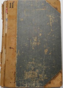
Document - LANDS OFFICE, INDEX OF CORRESPONDENCE INWARDS 1867, 1967
... PLACE Lands Office Bendigo Sandhurst correspondence land ...Journal: green hard covered journal with buff spine and corners. Contains details of inward correspondence 1967 onwards. Index in front of journal A-Z. Section after index has columns, local office No., date received, name, subject, instructions, how disposed of. On front '11' in black ink. On spine 'QQ' on white label.Lands officeplace, lands office, bendigo, sandhurst, correspondence, land sales -
 Forests Commission Retired Personnel Association (FCRPA)
Beechworth FCV District office sign
This sign proudly hung outside the Forests Commission Victoria (FCV) Beechworth office which is now site of the Forestry Heritage Museum. The granite building in the Beechworth's historic precinct was once the Gold Warden's Office and is one of the town's original buildings. The FCV was the main government authority responsible for management and protection of State forests in Victoria between 1918 and 1983. The Commission was responsible for ″forest policy, prevention and suppression of bushfires, issuing leases and licences, planting and thinning of forests, the development of plantations, reforestation, nurseries, forestry education, the development of commercial timber harvesting and marketing of produce, building and maintaining forest roads, provision of recreation facilities, protection of water, soils and wildlife, forest research and making recommendations on the acquisition or alienation of land for forest purposes″. The Forests Commission had a long and proud history of innovation and of managing Victoria's State forests but in September 1983 lost its discrete identity when it was merged into the newly formed Victorian Department of Conservation, Forests and Lands (CFL) along with the Crown Lands and Survey Department, National Park Service, Soil Conservation Authority and Fisheries and Wildlife Service. After the amalgamation the management of State forests and the forestry profession continued but the tempo of change accelerated, with many more departmental restructures occurring over the subsequent four decades. Responsibilities are currently split between the Department of Energy, Environment and Climate Action (DEECA), Forests Fire Management Victoria (FFMV), Parks Victoria, Melbourne Water, Alpine Resorts Commission, the State Government-owned commercial entity VicForests and the privately owned Hancock Victorian Plantations (HVP).Large office sign. Hand painted in traditional FCV mission brown and gold colour scheme.forests commission victoria (fcv), forest signs -
 Bendigo Historical Society Inc.
Book - LANDS OFFICE: INDEX LANDS AND SURVEY
Index lands and Survey. Sandhurst, Kangaroo Flat, Eaglehawk, White Hills, And Nerring. Land Sales, Beginning April 17, 1854. The last entry is dated 23.9.74. markings on spine of book are at top 04 in black, in gold lettering index lands and Survey, in black Bendigo, Eaglehawk, Kangaroo Flat White Hills and Nerring, near the bottom is the letter B in black, a white sticker with the letters VV. Read in conjunction with 2239 (a to g), located in Box 77.lands office, index, survey -
 Bendigo Historical Society Inc.
Document - LANDS OFFICE: REPORTS OF LAND SALES BY AUCTION 1876 - 1891, 1876 - 1891
... LANDS OFFICE: REPORTS OF LAND SALES BY AUCTION 1876 - 1891...Land sales kerang swan hill boort Sandhurst lands office ...Document: green hard cover journal, buff spine and corners. Contains details of land sales by public auction Kerang, Swan Hill and Boort. m LH page ' Lot, County, Town or parish, section, allotment, sold, unsold, why not sold, upset price, sold per acre. RH page: value of improvements, name of purchaser, residence, deposit forfeited, total amount. On spine in gold lettering ' report of sales by auction' underneath 'land sales' in black. No. 6 on top of spine, letter K on base.Lands Officeland sales, kerang, swan hill, boort, sandhurst, lands office -
 Bendigo Historical Society Inc.
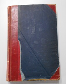
Document - LANDS OFFICE: SALE OF CROWN LANDS
Hard cover journal, green cover with buff spine and edges. Sticker on the front: Sale register 1934-1954. On the spine in red the number 16 and in black Land Sales 10-01-1934 to 31-12-1954. Pages entered with details of sales by public auction of crown lands. LH page: lot, county, town or parish, allotment, section, area, survey fee paid, upset price per lot, sold for per lot. RH page: value of improvements if any, name of purchaser, address, purchase money paid, grant fees and assurance paid.land sales, victoria, crown land sales, bendigo, central and northern victoria -
 Bendigo Historical Society Inc.
Document - LANDS OFFICE: APPLICATION REGISTER, SECTION 29 GRAZING AREAS LAND ACT 1898
... Land sales victoria Lands Office Bendigo application ...Document: hard cover indexed journal. On spine: red inset with 'Application Register' printed on gold, black inset with Section 29 Grazing Areas Land Act 1898' 'C' written in black ink. '35' and 1 - 1000' written above red inset. Journal has a loose slipcover of buff coloured linen-like material with cut-outs to allow information on spine to be viewed. Lh page: number of applications, date of registry, date of application, surname, Christian name and address, parish, allotment, section, area, local land board schedule. RH page: classification, lease, references and remarks. Details areas in central and northern Victoria. Dated from 22.12.1899 - 10.3.1906.land sales, victoria, lands office, bendigo, application register, applications for grazing land -
 Bendigo Historical Society Inc.
Document - LANDS OFFICE: CERTIFIED PLAN REGISTER
Document: hard cover journal. Buff cover with embossed edges. Spine has red insert with 'Certified Plan Register' printed in gold. 250 pages, with index in front of register. LH page: number, date of receipt, name, parish, tracing book, plan, decision of Board of land and works, gazette page, name of surveyors, date of survey, sent to, date. RH page: précis of minute. Dated 1878 - 1893, includes areas in central and northern Victoria.plan register, lands office, bendigo, plans, surveyed, victoria, northern victoria -
 Bendigo Historical Society Inc.
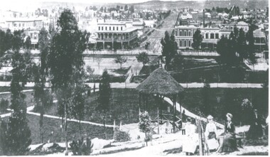
Photograph - LANDSCAPE - BENDIGO - PRE-POST OFFICE
Photograph - black and white. Photo of a view over Bendigo, Shamrock Hotel in middle left. Group of women in immediate foreground. Rosalind Park, creek then bare land. Written on back of photo 'Pre-Post Office Blng - began 1883, Open 1887.' Came with negatives under name of Davidson, negatives are not of the photo.place, landscape view, hargreaves street from rosalind par, bendigo. pre- post office. rosalind park. landscape -
 Bendigo Historical Society Inc.
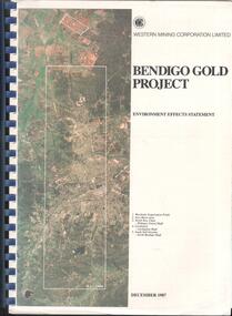
Booklet - Kangaroo Flat Gold Mine Collection: Western Mining Corporation Bendigo Gold Project Environmental Effects Statement December 1987, Western Mining Corporation, Bendigo Office, Western Mining Corporation Limited Bendigo Gold Project Environment Effect Statement December 1987, December 1987
Spiral bound booklet, plastic cover, black plastic binding, On front cover: Western Mining Corporation Bendigo Gold Project, Environment Effects Statement, December 1987. On front page, colour aerial photograph of Bendigo mining areas mentioned in report. Key on front page related to photograph: 1. Woodvale Evaporation Ponds. 2. New Moon area. 3. North New Chum Williams United shaft. 4. Carshalton, Carshalton shaft. 5. South Nell Gwynne, North Bendigo shaft. Contents: historical perspective; Western Mining Corporation Ltd Bendigo activities; project outline, project approvals - controlling factors, elements of the mining project, surface based exploration, underground operations and surface support, mining areas and operations ore and mullock haulage, New Moon area, water management, environmental management. Planning and land use, socio-economic environment, physical environment and biological environment are examined and discussed. bendigo, goldmining, bendigo mining nl, bendigo goldfield, environmental effects statement, bendigo gold project, woodvale evaporation ponds, new moon, north new chum, carshalton, south nell gwynne, western mining corporation -
 Bacchus Marsh & District Historical Society
Map, Allotments in the Village of Rowsley, Parish of Gorrocburkghap, County of Grant c.1856
Rowsley is a locality 11 kilometers south-west of Bacchus Marsh. The date of this map is uncertain. A very similar map held by the State Library of Victoria (SLV) contains slightly more information than this copy and is dated as an 1856 map. SLV reference: 'Allotments in the Village of Rowsley, Parish of Gorrocburkghap, County of Grant', by T. Nixon, Assistant Surveyor, May 1856 ; Surveyor General’s Office, July 18 1856 (lithographed by R. Meikle). (1856). Melbourne: Surveyor General’s Office. MAPS 820 BJE 1837- ROWSLEY 1856. A single page paper map. A cadastral map of the Village of Rowsley in Victoria, showing numbered land allotments. 57 allotments are shown on the map and some areas set aside as reserves. Allotments 8, and 10-16 are outlined in red ink and allotment 9 has a cross in red ink on it. The map is pasted into a bound volume containing 76 maps or plans in total. High resolution digital image stored on BMDHS computer network. rowsley victoria history, rowsley victoria maps -
 Bendigo Historical Society Inc.
Document - LANDS OFFICE BENDIGO LITHO REGISTER, Jan. 1952 - Feb. 1978
Document: hard cover journal, black cover with buff spine and corners. Contains register of land maps sold by Bendigo Lands Office. Handwritten entries on ruled pages. LH page: date, number received, name of plan, litho number, price, amount, date, name of plan, price, number sold, amount, number used in office, amount. Rh page: repeat of LH page.Lands Office Bendigobendigo, lands office, litho register -
 Eltham District Historical Society Inc
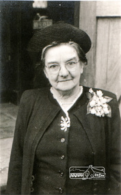
Photograph, Miss Elizabeth Doney
Elizabeth Doney (1880-1958) was a long time resident of Research, Vic. After the death of her parents, brother and sister-in-law she became the care giver for her nephews, while operating the town General Store and later Post Office, which she and before her, her parents managed for over eighty years. Elizabeth was also involved in many community activities including donating land (three house blocks) for the establisment of the Church of the Transfiguration, Research. Digital scan of photograph - Original Source Copy: St Margaret's Parish Archives. church of the transfiguration, elizabeth doney, research (vic.) -
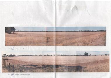 Bendigo Historical Society Inc.
Photograph - Kangaroo Flat Gold Mine Collection: photos of Woodvale site, Daly property, pre dam construction, 1986
Photographs taken at the time of the purchase by Western Mining Corporation of the property owned by G.P. Daly of Raywood Road, Woodvale, in 1986. The intent of the purchase was to provide land for the Woodvale ponds. Land size was 16 acres, known as Allotment 13, Section 3, Parish of Nerring. Paper with two colour photographs attached, each of three photos joined to show landscape view, of the property purchased from G.P Daly by Western Mining Corporation. Photographs show rural land, grassy paddocks with tree line in background. Barb wire fence visible in foreground of bottom photo. Top photograph is titled 23. Daly property looking south-east. Bottom photograph is titled 24. Daly property looking north east. woodvale, g.p. daly, western mining corporation, purchase -
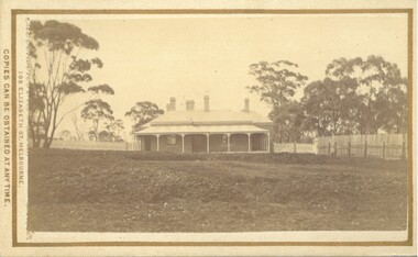 Bacchus Marsh & District Historical Society
Photograph, The Bungalow, house built for Doctor Rae, Bacchus Marsh 1883
This image is one of a series of photographs taken by Melbourne based photographers Stevenson and McNicoll who visited Bacchus Marsh and its nearby districts between September and November 1883. The house was built for Dr. Rae in 1880 following his retirement from his medical practice due to ill health. He lived there until his death. Dr. Vance then occupied it for a short time. It was bought by the sisters of St. Joseph in 1890 and formed the nucleus of St. Joseph’s Convent. It was demolished in the early years of the twentieth century, when a new two-storey brick convent was built.Small sepia 'carte de viste' style unframed photograph on card with gold border framing photograph. Housed in the Jeremeas Family Album which contains photographs of Bacchus Marsh and District in 1883 by the photographers Stevenson and McNicoll.The photo is of a large single-storey brick house with a return verandah supported by simple columns. Five chimneys can be seen. The house sits on a large block of land in a bush setting, with a hedge separating the house and garden. A picket fence runs across the block, with a paling fence along the northern side.Printed On the front: Stevenson & McNicoll. Photo. 108 Elizabeth St. Melbourne. COPIES CAN BE OBTAINED AT ANY TIME. On the back: LIGHT & TRUTH inscribed on a banner surmounted by a representation of the rising sun. Copies of this Portrait can be had at any time by sending the Name and Post Office Money Order or Stamps for the amount of order to STEVENSON & McNICOLL LATE BENSON & STEVENSON, Photographers. 108 Elizabeth Street, MELBOURNE. stevenson and mcnicoll 1883 photographs of bacchus marsh and district, doctors, houses bacchus marsh, convents, religious residences -
Federation University Historical Collection
Book - Report, Ballarat School of Mines Conservation Management Plan, 2016, 2016
The Ballarat School of Mines was the first school of mines in Australasia, and is a predecessor institution of Federation University Australia.CD-ROM of the SMB Campus Conservation Management plan, and a printout of the 390 page Draft report on the Federation University SMB Campus. Contents include: Establishment of the Wesleyan church Reserve Selection of a Site for the Ballarat Gaol and Court House Building the Court of Mines The Gaol Culvert The Ballarat School of Mines Establishment Ballarat iron Workers' Association Ballarat Technical Art School Ballarat School of Mines Museum Acquisition of Lewin's Land The Ballarat School of Mines site in c1970 Master Planning Flecknoe Biulding The Ballarat School of Mines in 1988 Architectects Caselli, Figgus, Molloy and Smith. Public Work Department Architects Ballarat School of Mines Botanical Garden Former Ballarat Junior Technical School Administration Building - Building A W.J. Gribble Building (Ballarat Technical Art School) - Building B Old Chemistry Building Building C Amenities Building, Governor's Quarters, Gaol Gatehouse and Watch Tower and Gaol Walls - Building D Courthouse Theatre (Former Ballarat Supreme Court) - Building F A.W. Steane Building (Former Ballarat Junior Technical School) - Building J Flecknoe Building and E.J. Barker Building (Building N) Old Plumbing Building - Builidng ) Unistyle Haridressing Building (Formerly Ballarat School of Mines Museum and Wesleyan Church) - Building P david rowe, wendy jacobs, ballarat school of mines conservation management plan, ballarat school of mines, buildings, wesleyan church reserve, former ballarat gaol, court of mines, circuit courthouse, gal culvert, ballarat school of mines museum, ballarat technical art school, x-rays, ballarat junior technical school, motor mechanics, wool classing, former governor's quarters, library, flecknoe building, former supreme court, architects, henry richards caselli, figgis, molloy and smith, public work department architects, ballarat school of mines botanic garden, former ballarat junior technical school commemorative gardem, w.j. gribble building, old chemistry building, amenities building, former warden's quarters, courthouse theatre, a.w. steane building, old plumbing building, unistyle hairdressing building, former ballarat post office, post office gallery, former ballarat government offices, cmp, conservation management plan, ballarat school of mines campus, smb campus -
 Melbourne Tram Museum
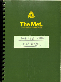
Document - Report, The Met, "Wattle Park", 1989
Report - approx. 90 A4 photocopied sheets, within a green cover preprinted for "The Met", titled "Wattle Park" containing many documents concerned with the history of Wattle Park and its status legally within a black comb binder. Comprises: 1 - Map 2 - two page letter from Tom Roper Minister for Planning and Environment to Jim Kennan Minister for Transport dated 22/11/1988. 3 - two page history 4 - two page extract from the Nov - Dec 1966 issue of MMTB News 5 - 23 pages - handwritten "Notes of Address on early history of Wattle Park given by A. J. Holt to the Box Hill Historical Society Nov. 1986. 6 - 10 page extract of the Act authorising the HTT to acquire the land and extracts from Hansard 7 - 4 page letter by the Office of the Solicitor to The Met Property department 1/12/1986 about the use of the land and charging fees for its use. 8 - 15 page legal advice re the use of the land and its permitted uses. 9 - 13 page follow up advice by P. N. Wikrama dated 20/6/1989 10 - 6 page photocopy of the certificates of title. Each section separated by a green sheet.trams, tramways, wattle park, legal agreements, htt, mmtb, the met, minister for transport -
 Melbourne Tram Museum
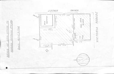
Drawing, Melbourne & Metropolitan Tramways Board (MMTB), "Detail of land leased to Alfred Kefford Pty Ltd", undated
Photocopy of a drawing or plan on an A4 sheet, titled "Detail of land leased to Alfred Kefford Pty Ltd" and the back of the former MMTB Office building in Victoria Parade Fitzroy. Gives the block dimension, streets, a location of a workshop and the brick office building. The Young St sub-station was excluded. Gives details of the fences. Plan undated. Rod Atkins advised 29/7/19 that Alfred Kefford nee Pty Ltd. resided at no 17 Young Street on corner of Duke Street just several doors further up Young Street on the same side. All I know so far is they were into some form of delivery type transport - i.e.. carrier.trams, tramways, mmtb, buses, lease agreement, victoria parade, young st, substation -
 Melbourne Tram Museum
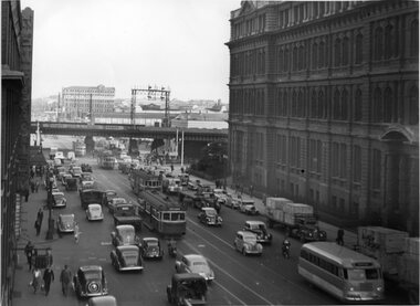
Photograph - set of 9 Black & White Photograph/s, Melbourne & Metropolitan Tramways Board (MMTB), 1966
Series of 9 black and white photographs of the traffic congestion in the CBD during 1951. .1 - view looking south along Spencer St from Collins St showing the VR Head office, and the railway viaduct with a Berger Paint advertisement, Has one wide body tram with dash canopy lighting and three W2's. Also one small bus. Has "G3" in pencil on rear. .2 - similar view but with a different vehicle mix - W2 317 (Richmond Route 28), an SW6 route 27 and another W2 (route 41). Includes one large truck carrying Land Rover boxes. Typed on rear "Enlargement of No. 72 - Sheet No. 26 (Report P25/1/8) and in ink initials and "For Testing Engs 1/11/51". .3 - View looking north along Swanston St Princes Bridge with a route 6 tram and Princes Bridge Station and St Pauls Cathedral. On rear in pencil "11/2" .4 - Spencer St - trams crossing Spencer St bridge - W5 781 (Route 10) and a W2 649, route 9, South Melbourne Beach. .5 - Queensbridge under bridge - showing many cars jammed and the railway viaduct. .6 - ?? - Collins St - National Mutual and Shaw Savill Line offices - has a Safety Zone stand. .7 - Collins St looking east from Market St - with many trams in the view and many cars. .8 - Collins at Market St with a SW6 with dash canopy lighting - route 45, followed by a route 9A .9 - same location - total chaos. See also Reg 4520 for another 7 photos of the same series.trams, tramways, traffic control, congestion, spencer st, route 27, route 28, route 41, route 6, princes bridge, swanston st, w2 class, sw6 class, route 10, route 9, spencer st bridge, market st, collins st, route 45, route 9a, tram 317, tram 781, tram 649