Showing 1501 items
matching natives
-
 Stawell Historical Society Inc
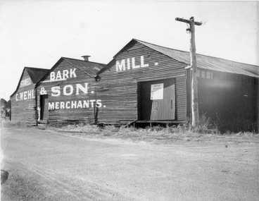
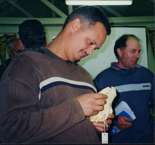
Photograph, Mr Carl Wehl and Son's Bark Mill in Taylor Street -- 2 Photos -- 1 Coloured
Carl Wehl and Son Bark Mill, located in Taylor Street Stawell. The coloured photo depicts what remains of the building in Taylor St. Stawell. The mill has not been used for many years. The original factories were on Stawell Flat. Carl Wehl a native of Hanover, Germany came to Victoria in 1861. Carl Wehl was at Pleasant Creek in 1872 when he started business as a wool scourer and tanner. By 1880 his business of tanning wool scouring discontinued, and he commenced trading, (mongering) in Bark Milling. The Mill was described as being the largest of its kind outside Melbourne,Two photographs of a weather board building with corrugated iron roof. One black & white photo and an enlarged photo of the building when used as a Bark Mill. The coloured photo obviously more recent as the writing has faded and can just be made out on the front of the building. One of the original colour photos is missing (152-2). A disused railway line can be seen in the foreground. Sign on the door "Depot Wimmera." Stawell Bark Mill C. Wehl & Son. Merchants.stawell -
 Bacchus Marsh & District Historical Society
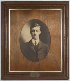
Photograph, Portrait, Roy Staughton, 1888-1910
Roy Staughton was a member of the Staughton family who were among the early and prominent pastoralists in the Bacchus Marsh and Melton area. His Father was Samuel Thomas Staughton Snr a member of the Parliament of Victoria for over 20 years and whose properties included Eynesbury near Melton. Samuel Staughton died in 1901. In 1910 while working in New South Wales Roy Staughton contracted Typhoid and died aged only 22. This portrait was first presented to the Bacchus Marsh Branch of the Australian Natives Association a few months after his death by his Mother Mrs. Eliza. Staughton, Framed portrait photograph of Roy Staughton. The image is framed within an oval shaped inner frame with an inscribed plaque at the bottom of the frame which reads: ‘Mr Roy Staughton, born May 16th 1888, Died Feby (sic) 22nd 1910’.‘Mr Roy Staughton, born May 16th 1888, Died Feby (sic) 22nd 1910’.roy staughton 1888-1910, staughton family bacchus marsh -
 St Kilda Historical Society
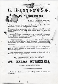
Document - Advertisement, G Brunning & Son St Kilda Nurseries, Pre - 1901 (original)
George Brunning was born in Suffolk, England, on 2 October 1830 and settled in St Kilda in June, 1852. He was a gardener and became part-proprietor and manager of Rule's Nursery in Richmond before establishing the first nursery of his own in 1861. Following his death on 5 June 1893, his sons continued the business. An article published in Punch in 1907 observed 'Nearly all the flowers grown in and around Melbourne, indeed, throughout Victoria, which are not native to Australia, had their origins in the nurseries of George Brunning and Sons. The statement is a large one to make, but it is literally true.'Single page black and white photocopy of advertisement from an unidentified publication for G Brunning & SonG Brunning & Son, St Kilda Nurseries, Near Melbourne, Beg to announce they have the Largest and Most Extensive Nursery Stock in the Australian Colonies. Ten acres of our ground are under cultivation with Flowers and Shrubs, upwards of two acres being covered with pot grown plants. We are the biggest Importers of new florists flowers in the Southern Hemisphere, always adding to our Stock all the Novelties as they appear in Europe. Our nurseries are particularly noted for the fine collections of roses, show, fancy and zone pelargoniums, fuchsias, picots, carnations, and other leading Plants, Shrubs, etc. In addition, we cultivate extensively the best and most popular kinds of fruit trees, of sorts suitable for private gardens, or for market purposes. Priced Catalogues are published annually in May, and will be forwarded gratis on application to G Brunning & Son, St Kilda Nurseries, Near Melbourne. Visitors to Melbourne are respectfully invited to inspect our Nurseries.g brunning and son, plant nurseries victoria, st kilda, 19th century -
 Wangaratta RSL Sub Branch
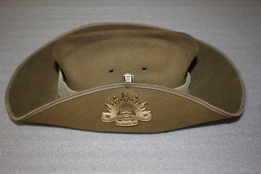
Headwear - Army Slouch Hat, Fayrefield of Melbourne
History has it that the origins of the Slouch Hat began with the Victorian Mounted Rifles; a hat of similar design had been worn in South Africa by the Cape Mounted Rifles for many years before 1885. The design of the Victorian Mounted Rifle hat originated from headgear of native police in Burma where Lieutenant-Colonel Tom Price had recognised its value. The Victorian hat was an ordinary bush felt hat turned up on the right side. The intention of turning up the right side of the hat was to ensure it would not be caught during the drill movement of “shoulder arms” from “order arms”. The Slouch Hat became standard issue headdress in 1903 and its brim position was mostly standardised. The slouch hat became a famous symbol of the Australian fighting man during World War One and continued to be worn throughout World War Two. Its use since that time has made it a national symbol.Slouch Hat - made of fur felt with an 8 fold hat band (puggaree) it has the blue/gold unit badge on the band denoting the 8th Light Horse brigade with a leather chin strap. The right hand side is held by a brass rising sun badge.army, slouch hat -
 Wooragee Landcare Group
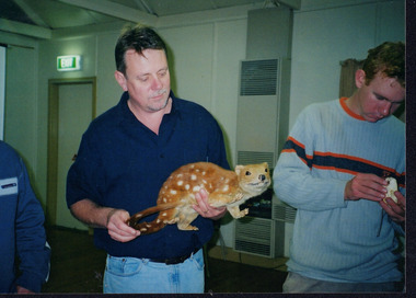
Photograph, 28th April 2004
Wooragee Landcare was formed in 1989 to promote sustainable conservation and land-use practices in the North-East region of Victoria. The organisation's work has included public awareness and education campaigns to control invasive, introduced species and protect native wildlife, such as campaigns to bait or trap foxes and to identify and monitor quoll populations in the region. The organisation has drawn on the work of a variety of Government and academic experts to inform best practice approaches are utilised. In 2004 Andrew Murray, a leading quoll expert from Parks Victoria, conducted training for Wooragee Landcare members and the local community in how to identify potential quoll habitat and populations (through identifying scat and other methods). Spotted-tail or Tiger quolls were known to have lived in the Mt Pilot and Stanley Plateau region previously but habitat encroachment, competitor species such as foxes and natural disasters had reduced sightings in recent years. The Spotted-Tail quoll (formerly known as the Tiger Quoll) is the largest of four species of native marsupial carnivore on mainland Australia, and the second-largest carnivore (after the dingo). The species' scientific name, Dasyurus maculatus, references its' 'hairy tail'. Adults are approximately 125cm long, including their long tail, and weigh around 5 kilograms. The Spotted-tail quoll is currently considered to be a threatened species, but other species are currently listed as endangered. This photograph is significant as an example of wildlife protection awareness programs undertaken by Wooragee Landcare Group in the 2000s in Indigo Shire.Landscape coloured photograph printed on gloss paper.Reverse: WAN NA 0ANA2N0 NNN+ 2 8743 / [PRINTED] (No.22) / 268wooragee, wooragee landcare, kiewa landcare, indigo shire, north-east victoria, farming, conservation, wildlife, quoll, quolls, marsupials, predators, simon feillafe, andy murray, south-east forests, spotted tail quoll, mt pilot, stanley plateau, andrew murray -
 Wooragee Landcare Group
Photograph, 28th April 2004
Wooragee Landcare was formed in 1989 to promote sustainable conservation and land-use practices in the North-East region of Victoria. The organisation's work has included public awareness and education campaigns to control invasive, introduced species and protect native wildlife, such as campaigns to bait or trap foxes and to identify and monitor quoll populations in the region. The organisation has drawn on the work of a variety of Government and academic experts to inform best practice approaches are utilised. In 2004 Andrew Murray, a leading quoll expert from Parks Victoria, conducted training for Wooragee Landcare members and the local community in how to identify potential quoll habitat and populations (through identifying scat and other methods). Spotted-tail or Tiger quolls were known to have lived in the Mt Pilot and Stanley Plateau region previously but habitat encroachment, competitor species such as foxes and natural disasters had reduced sightings in recent years. The Spotted-Tail quoll (formerly known as the Tiger Quoll) is the largest of four species of native marsupial carnivore on mainland Australia, and the second-largest carnivore (after the dingo). The species' scientific name, Dasyurus maculatus, references its' 'hairy tail'. Adults are approximately 125cm long, including their long tail, and weigh around 5 kilograms. The Spotted-tail quoll is currently considered to be a threatened species, but other species are currently listed as endangered.This photograph is significant as an example of wildlife protection awareness programs undertaken by Wooragee Landcare Group in the 2000s in Indigo Shire.Landscape coloured photograph printed on gloss paper.Reverse: WAN NA 0ANA2N0 NNN+ 1 8743 / [PRINTED] (No.23) / 269wooragee, wooragee landcare, indigo shire, north-east victoria, andrew murray, queries about quolls, wildlife, conservation, farming, predators, spotted tail quolls, quolls, marsupials, south-east forests, mt pilot, stanley plateau -
 University of Melbourne, Burnley Campus Archives
Plan, Burnley Theme Gardens, 1988-1989
Plans for Victorian College of Agriculture and Horticulture, Burnley Campus, Second Year Associate Diploma Students. All Scale 1:50. Tracing paper, paper and laminated copies. (1) Scented Garden, designed by G. Fryer, drawn by S. Mullany. October 1988. (2) Native Garden, designed by L. Garn(e)tt, drawn by S. Mullany, October 1988. (3) Contemporary Garden, designed by Sara Esposito, drawn by Clive Sorrell, May 1989. (4) Grass Garden, designed by E. Youssef, drawn by S. Mullany, October 1988. (5) Victorian Garden, designed by W. Bergin, drawn by S. Mullany, October 1988.vcah, burnley campus -
 University of Melbourne, Burnley Campus Archives
Album - Glass slides, W. H. Cooper, Glass Lantern Slides Full Collection, 1900s-1950s
Sandra Pullman visited the Melbourne City Council Exhibition, 'Melbourne Parks and Gardens Through the Magic Lantern' in November 2012. Lex Nieboer, former Burnley student graduating in 1975, found a large number of glass lantern slides in a store room and took them home as he was concerned they would be thrown out. His family has a long tradition of being involved in photography, so he understood the value of the slides. He donated the ones that were of Melbourne City Parks and Gardens to the Council and they used them in their exhibition. Sandra contacted Lex and arranged with Jane Wilson (Archivist) to visit Lex on 12 April, 2013 at Wilson Botanic Park, Berwick where he works. After Lex showed them the slides, he, very generously, donated approximately 300 slides back to the Burnley Archives. There was already a collection of almost 100 glass slides in the Archives. They were in a wooden box containing glass lantern slides with label on outside, "Slides of Horticultural Objects and Views." Inside lid is handwritten, "Mr Bailey Botanic Gardens Adelaide." (John Frederick Bailey, Director Adelaide Botanic Gardens 1917-1932.) and, "Mr Isaac 9 pla? 2 ficifolia." (Probably Mr Isaacs Mayor of Adelaide 1917.) Also, "Purchased from Estate of Reeves Late Malvern Gardens, AWJ." (F.L. Reeves, Malvern Council's Park Curator in the 1920's died in 1933. AWJ, A.W. Jessep, Principal Burnley Horticultural College 1926-1941.) These were numbers 61-85 "History of the Rose." Geoff Olive, former Staff member, remembered taking a number of glass slides to a photographic processor to have 35mm slides made from them. 60 of these are also in this collection. Also see B10.0057 for Melbourne City Council collection and, 11.0039, 12.0033 for photograph prints of lantern slides lost to the collection.Collection of approximately 400 glass lantern slides used for teaching at Burnley Horticultural College during the first half of the twentieth century. Some were made specifically for Burnley. Some images would not upload. The images include: overseas views of gardens, historical sites and geographical features (some hand coloured from Japan); a series of hand coloured images of roses with notes for teaching the history of the rose; school gardens of the early 1900's; fruit and vegetables; miscellaneous horticulltural; Australian native plants; cells; 'Living Races'; plants, trees and grasses; parasites, organisms and fungal diseases; miscellaneous horticultural scenes; parks; cattle; agricultural data.sandra pullman, lex nieboer, melbourne city council exhibition through the magic lantern, john frederick bailey, mr isaacs, f l reeves, a w jessep, history of the rose, plants, trees, diseases -
 Federation University Historical Collection
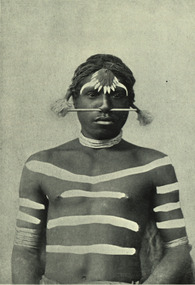
Image - black and white, Barwon River Man (New South Wales)
Digitised directly from 'The Native Races of the British Empire: Victoria' The Barwon River in New South Wales is formed through the confluence of the Macintyre River and Weir River (part of the Border Rivers system), north of Mungindi, in the Southern Downs region of Queensland. The Barwon River generally flows south and west, joined by 36 tributaries, including major inflows from the Boomi, Moonie, Gwydir, Mehi, Namoi, Macquarie, Bokhara and Bogan rivers. During major flooding, overflow from the Narran Lakes and the Narran River also flows into the Barwon. The confluence of the Barwon and Culgoa rivers, between Brewarrina and Bourke, marks the start of the Darling River.Black and white Image of an Aboriginal man from Barwon River, New South Wales. Aboriginal people from six language groups originally occupied the area of the Barwon River wetlands. These were the Ngemba, the Baranbinja, the Murrawari, the Ualayai, the Weilwan, and the Kamilaroi peoples. The Aboriginal people generally used the wetlands for hunting, fishing, and gathering uses, and for cultural association.(Wikipedia) The name "barwon" is derived from the Australian Aboriginal words of barwum or bawon, meaning great, wide, awful river of muddy water; and also baawan, a Ngiyambaa name for both the Barwon and Darling rivers. The history, culture and livelihoods of the local Aboriginal people are closely intertwined with the Barwon River and its associated tributaries and downstream flows. (Wikipedia)aborigine, aboriginal, barwon river -
 Federation University Historical Collection
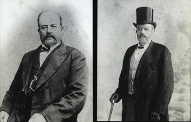
Photograph - Black and White, Alexander Peacock
Alexander Peacock was born in Creswick, Victoria in 1861. Upon leaving school he mined and was legal manager of mining companies in Ballarat. In 1882 he joined the Creswick branch of the Australian Natives' Association (ANA) and became branch secretary. He stood for parlimnet in March 189 and was elected to the Legislative Assembly representing Clunes and Allandale. Peacock assisted in the establishment f the Clunes Branch of the Ballarat School of MInes which opened in 1890. He was one of the Victorian delegates to teh Federal Convention in 1897. He laid the foundation stone of the new SMB Classroom building in 1899 while MInister for Public Instruction. Three photographs of Alexander Peacock. .1) Portrait of Alexander Peacock printed from an original .2) Portrait of Alexander Peacock in a jacket, balding and with a moustache. Photo is printed from an original. .3) Portrait of Alexander Peacock in a top hat and tails, holding a walking stick. Photo is printed from an original.alexander peacock, australian natives' association, ana, ballarat school of mines, parliamentarian, legislative assembly, mininster for public instruction, minister for education -
 Kew Historical Society Inc
Photograph - Willsmere [Kew] Billabong, 1993
Willsmere Park is bounded by the the Yarra River, Green Acres Golf Club, Willow Grove and the Eastern Freeway. The land on which the park is now situated was bought by Thomas Wills at the Crown Land Sales of 1846 (Section 56). From the 1840s to the 1940s it was intensively farmed. The park is dominated by very large playing fields, while planting to the southern boundary was undertaken when the Eastern Freeway was built. It is only along the banks of the Yarra that there is any remnant native vegetation. Willsmere Park is of significance as an area of open land that remains from the flood plain that once dominated northern Kew. (Source: Kew Conservation Study, 1988)Original colour small format polaroid photograph of the 'Kew Billabong' in the Willsmere Park, taken on 16 September 1993."Willsmere Billabong 16.9.93"kew billabong, willsmere park, yarra river -- billabongs -
 Kew Historical Society Inc
Photograph - Yarra River in flood at the Willsmere Park, 1993
Willsmere Park is bounded by the the Yarra River, Green Acres Golf Club, Willow Grove and the Eastern Freeway. The land on which the park is now situated was bought by Thomas Wills at the Crown Land Sales of 1846 (Section 56). From the 1840s to the 1940s it was intensively farmed. The park is dominated by very large playing fields, while planting to the southern boundary was undertaken when the Eastern Freeway was built. It is only along the banks of the Yarra that there is any remnant native vegetation. Willsmere Park is of significance as an area of open land that remains from the flood plain that once dominated northern Kew. (Source: Kew Conservation Study, 1988)Original colour small format polaroid photograph of the Yarra River in flood at the Willsmere Park, taken on 16 September 1993."Yarra River at Willsmere Park Flooding 16.9.93"willsmere park, yarra river -- floods -- kew (vic.) -
 Kew Historical Society Inc
Photograph - Flooding in the Willsmere Park, 1993
Willsmere Park is bounded by the the Yarra River, Green Acres Golf Club, Willow Grove and the Eastern Freeway. The land on which the park is now situated was bought by Thomas Wills at the Crown Land Sales of 1846 (Section 56). From the 1840s to the 1940s it was intensively farmed. The park is dominated by very large playing fields, while planting to the southern boundary was undertaken when the Eastern Freeway was built. It is only along the banks of the Yarra that there is any remnant native vegetation. Willsmere Park is of significance as an area of open land that remains from the flood plain that once dominated northern Kew. (Source: Kew Conservation Study, 1988)Original colour small format polaroid photograph of flooding in the Willsmere Park, taken on 16 September 1993."Flooding of shared path from Willsmere Billabong 16.9.93"willsmere park, yarra river -- floods -- kew (vic.), kew billabong -
 Kew Historical Society Inc
Photograph - Flooding in the Willsmere Park, 1993
Willsmere Park is bounded by the the Yarra River, Green Acres Golf Club, Willow Grove and the Eastern Freeway. The land on which the park is now situated was bought by Thomas Wills at the Crown Land Sales of 1846 (Section 56). From the 1840s to the 1940s it was intensively farmed. The park is dominated by very large playing fields, while planting to the southern boundary was undertaken when the Eastern Freeway was built. It is only along the banks of the Yarra that there is any remnant native vegetation. Willsmere Park is of significance as an area of open land that remains from the flood plain that once dominated northern Kew. (Source: Kew Conservation Study, 1988)Original colour small format polaroid photograph of flooding in the Willsmere Park, taken on 16 September 1993."Flooding of Willsmere Park from Yarra 16.9.93"willsmere park, yarra river -- floods -- kew (vic.) -
 Kew Historical Society Inc
Photograph - Flooding of Willsmere Park from Yarra, 1993
Willsmere Park is bounded by the the Yarra River, Green Acres Golf Club, Willow Grove and the Eastern Freeway. The land on which the park is now situated was bought by Thomas Wills at the Crown Land Sales of 1846 (Section 56). From the 1840s to the 1940s it was intensively farmed. The park is dominated by very large playing fields, while planting to the southern boundary was undertaken when the Eastern Freeway was built. It is only along the banks of the Yarra that there is any remnant native vegetation. Willsmere Park is of significance as an area of open land that remains from the flood plain that once dominated northern Kew. (Source: Kew Conservation Study, 1988)Original colour small format polaroid photograph of flooding in Willsmere Park resulting from heavy rain on 15 September 1993."Flooding of Willsmere Park from Yarra 16.9.93"yarra river -- floods -- kew (vic.), willsmere park -
 Kew Historical Society Inc
Photograph - Willsmere [Kew] Billabong, 1993
Willsmere Park is bounded by the the Yarra River, Green Acres Golf Club, Willow Grove and the Eastern Freeway. The land on which the park is now situated was bought by Thomas Wills at the Crown Land Sales of 1846 (Section 56). From the 1840s to the 1940s it was intensively farmed. The park is dominated by very large playing fields, while planting to the southern boundary was undertaken when the Eastern Freeway was built. It is only along the banks of the Yarra that there is any remnant native vegetation. Willsmere Park is of significance as an area of open land that remains from the flood plain that once dominated northern Kew. (Source: Kew Conservation Study, 1988)Original colour small format polaroid photograph of Willsmere [Kew] Billabong on September 1993."Willsmere Billabong 16.9.93"yarra river -- floods -- kew (vic.), willsmere park -
 Harcourt Valley Heritage & Tourist Centre
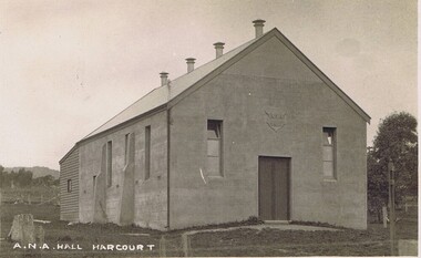
postcard, A N A Hall, Harcourt, 1915
Harcourt branch of the Australian Natives Association was formed in 1908, meeting in a chaff shed behind the local grocer shop. In 1911 the branch contracted with Mr Sutherland of Barkers Creek to build a hall of boxed concrete construction. Sutherland was a pioneer in the use of concrete for structural purposes.He subsequently had a career as City Engineer at Camberwell. The ANA branch conducted many social occasions in the hall and gave community leadership for upwards of fifty years in addition to its friendly society/health insurance activities.. This was the only community hall in the Harcourt community until it was superseded by the Harcourt Leisure Centre in 1991 It is now the home of Harcourt Heritage Centre.A community hall of pioneering construction method, provided to the community by a friendly society.black and white postcard depicting a community hallA N A Hall, Harcourt -
 Eltham District Historical Society Inc
Photograph - Digital Photograph, Marguerite Marshall, Gordon Ford's Garden, 'Fulling', Pitt Street, Eltham, 10 November 2006
'Fulling', the half-hectare property at Pitt Street, Eltham was the home of landscape designer Gordon Ford and his wife Gwen. Ford bought the property in 1948, originally part of an orchard. The garden encapsulates the major trends of Australian garden design in the second half of the 20th century. The garden design is based on mass (plants) and void (paths and pools), textures and forms. It epitomises the Eltham style because of its relaxed informality and attraction to native wildlife. Covered under Heritage Overlay, Nillumbik Planning Scheme. Published: Nillumbik Now and Then / Marguerite Marshall 2008; photographs Alan King with Marguerite Marshall.; p147This collection of almost 130 photos about places and people within the Shire of Nillumbik, an urban and rural municipality in Melbourne's north, contributes to an understanding of the history of the Shire. Published in 2008 immediately prior to the Black Saturday bushfires of February 7, 2009, it documents sites that were impacted, and in some cases destroyed by the fires. It includes photographs taken especially for the publication, creating a unique time capsule representing the Shire in the early 21st century. It remains the most recent comprehenesive publication devoted to the Shire's history connecting local residents to the past. nillumbik now and then (marshall-king) collection, eltham, fulling, gordon ford garden, pitt street -
 Ballarat Tramway Museum
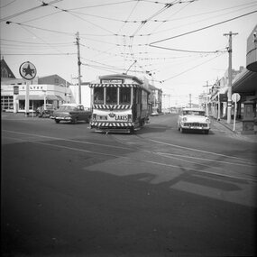
Photograph - Set of four black and white negatives of Ballarat trams, Warren Doubleday, 20-4-1968
Photos 25-4-69, of: .1 - Ballarat 17 at Stones Corner with Caltex Service Station in the background. Tram leaving Main Road before joining Bridge St. .2 - No. 28 running from Bridge Street into Sturt Street with a "Trotting at Bray Raceway Tonight" Auxillary board. Tram has the destination of Gardens via Sturt St West. In the background are the Big W and the Dickins Store. .3 - Tram 43 on "0" road at the SEC Ballarat Depot. .4 - Tram 13 at the Gardens Loop in Wendouree Parade. Tram has an ANA Hospital and Medical Benefits (Australian Natives Association) Advertising Board.Yields information about the operation of the Ballarat tramway system that was operated by the State Electricity Commission of Victoria.Set of four black and white negatives of Ballarat Tramways, 120 size. ballarat, trams, tramways, sturt street, tram 17, main road, bridge street, tram 28, bray raceway, dickins, big w, tram 13, ana health, wendouree parade, gardens loop, depot, tram 43, stones corner, caltex -
 Victorian Aboriginal Corporation for Languages
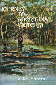
Book, Aldo Massola, Journey to Aboriginal Victoria, 1969
Looks at the Aboriginal community from the time of white contact, across many parts of Victoria. Chap.1; Melbourne - early missions, camp of Native Police, corroboree trees, canoe trees, grave &? headstone of Derrimut; quarries at Keilor, excavation sites at Green Gully &? Keilor; quarry at Mt. William, notes on inheritance of quarries Coranderrk settlement - Barraks grave, notes on his life; Chap.2; Geelong - Yawangi group of the Wothowurong tribe, camping grounds in area quarries; Notes on William Buckley, Gellibrand (a notable Aboriginal), graves in the Western Cemetery; Chap.3; Colac - war between Colac &? Geelong tribes; Mission at Birregurra, reason for failure of Buntingdale Mission; brass plate to Coc-coc-coine; reserve at Elliminyt, native ovens, camp sites, initiation site &? ritual; quarry sites, axegrinding factory, rock pecking &? engraving; dried hand &? 3 Aboriginal skulls found; Chap.4; The south-west coast - middens, camp sites notes on Framlingham Stn., fish traps at Tyrendarra; Chap.5; The far west - massacres of Aborigines near Casterton; camp sites, oven mounds; the first cricket team formed; Aboriginal cemetery; Chap.6; Hamilton - camps; Mount Rouse Station, axegrinding grooves at Nareeb Nareeb, shelters described, fish traps, massacre at Lake Condah; mission; canoes; Chap.7; Camperdown - legend about Lake Bullen Merri; obelisk erected in memory of Aborigines of district especially chief Wombeetch Puyuun; Jarcoort tribe; fish weirs, camps, intertribal fights between Booluc-burrers, Jarcoorts &? Ellengermote groups; bartering place at Mount Noorat; articles traded, legend of Flat-Top Hill; Chap.8; Ballarat - camp at Lake Wendouree; White Stone Lagoon; legends concerning Mt. Buninyong &? waterfalls at Lal-lal; camp sites; pygmy-type implements near Meredith, quarry at Glue Pot Rocks near Durdidwarrah; brass plate of King Billy; Chap.9; Ararat - Tjapwurong territory; camp sites, quarries, shield &? canoe trees; Bunyip belief at Lake Buninjon of Muk-jarawaint &? Pirtkopen-noot tribes, gives legend; stone implements; mill stones; fish weirs; stone arrangement near Lake Wongan; ground drawing of a bunyip, paintings in rock shelter near Mt. Langi Ghiran; Chap.10; Maryborough - camps, oven mounds, rock wells, stone arrangement at Carisbrook; camp sites at Mt. Franklin; Chap.11; Charlton - belief in Mindye (snake); canoe trees, ovens, camp sites, water holes, rock wells, stone implements; method of rainmaking; Chap.12; Horsham-Stawell, The Wimmera - Wotjobaluk land; camps, fish traps at Toolondo; Black Range cave paintings, Flat Rock shelters (detailed account of these paintings); Bunjils Cave; Chap.13; Horsham-Stawell, The Mallee - camp sites, implements; Ebenezer Mission, Willie Wimmera taken to England by Rev. Chase to become a missionary, died in England; Chap.14; The Murray River, Mildura Swan Hill - Battle of the Rufus; ceremonial ground, Lake Gol Gol, canoe &? shield trees; stone implements; camp sites, fire place arrangements; fish traps; oven mounds; Chap.15; The Murray River, Swan Hill-Echuca - legend about Lake Boga; camps, oven mounds, the Cohuna skull, Kow Swamp, method of burial; Chap.16; Shepparton ovens; brass plates of King Paddy of Kotupna &? King Tattambo of Mulka Stn., native well, camps; Chap.17; Wangaratta -camps, quarry, rock holes, the Faithful massacre; grinding rocks at Earlston; Chap.18; The High Plains - Ya-itma-thang; camps, Bogong moth feasts, native paths for trade &? intertribal fights, articles traded; painted shelters; Koetong Ck. Valley, near Mt. Pilot &? near Barwidgee Ck.; Chap.19; Dandenong - water holes, list of 8 holes in Beaumaris - Black Rock area; camps, middens, stone implements (microliths), legend of Angels Cave, stone axes, Native Police Force, Narre Narre Warren Station, legend about rocks on Bald Hill, kangaroo totemic site; Chap.20; Wonthaggi- Yarram - natives visit Phillip Is., murder of William Cook and Yankee by five Tasmanians (listed as Bon Small Boy, Jack Napoleon Timninaparewa, Fanny Waterpoordeyer, Matilda Nattopolenimma and Truganini) near Cape Patterson, men; camp sites, middens, legend of White Rock; Chap.21; Sale - Bairnsdale, The Lakes Country middens, camps; legend at Wulrunjeri; story of a white woman supposedly living with with the Tutangolung tribe, efforts made to prove story; canoe trees; Chap.22; Sale-Bairnsdale, The Inland Braiakolung tribe, camps, implements, canoe &? shield trees; Ramahyuck Mission, grinding rocks, fights with Omeo tribe; native tracks, death through enemy magic - procedure, belief in ghosts; Chap.23; Lakes Entrance and the Country to the east - Kroatungolung people, legend of Kalimna Valley; camps, stones of Nargun, bunyip, devils at Lake Tyers, excavation at Buchan, carbon dates; middens, ochre at Cape Conrad, stone fish-hook file at Thurra River; note on Bidwel tribe; Each chapter gives historical details, early contacts, relationships with settlers; Aboriginal place names and detailed description of sites and geographical features.b&w photographs, b&w illustrations, colour illustrationsgeelong, colac, hamilton, camperdown, ballarat, ararat, maryborough, charlton, horsham, stawell, murray river, shepparton, wangaratta, dandenong, wonthaggi, yarram, sale, bairnsdale, lakes entrance -
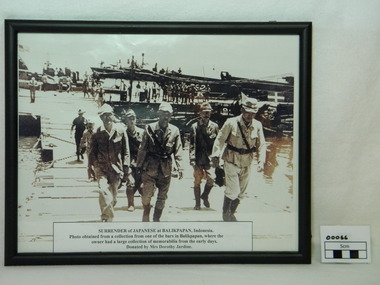 Red Cliffs Military Museum
Framed Photograph, Surrender of Japanese at Balikpapan, 1945
Japanese Commanders crossing a pontoon bridge under guard by Australian soldier on the way to the official surrender of Japanese forces in Balikpapan in (Dutch East Indies) Indonesia 1945. This was a major event in the ending of World War 2. Following the japanese surrender the Local population began it push for independance. Framed photograph (copy) of Japanese Commanders surrendering at Balikpapan. Black frame and glass covered. The Japanese Command staff with a Japanese general and aid-d-camp (Captian)carring his breif case along with other staff members. In the background here are 2 American PT boats with American naval personal .Note American flag flying in the top left corner. There are several American landing craft next to a Japanese landing barge. The Japanese landing bardge has the required surrender markings which is a green square with a white cross on top right of photo. The Australian soldier following the Japanese soldiers is wearing slouch hat and gungle green uniform. Along the docks are native workers.Paper discription on lower photograph with details of item description, where photo obtained from and donated by.ww2, japanese, surrender, balikpapan, generals, americans, pt boats, japanese landing bardge, american landing craft, dutch east indies -
 University of Melbourne, Burnley Campus Archives
Album - Black and white and colour prints, colour 35mm slides, Geoff Olive, Geoff Olive Collection, 1979-2000
Collection of photographs and slides taken by Geoff Olive (Horticultural Instructor). (1) "Burnley 1979 Flash flood outside engineering." (2, 3) Administration Building, different years. (4) "Trish Mooney Gardener 1998." (5) 15-7-00 Ellis Stones Garden Friends Working Bee Tim and Chris." (6, 7) "Photos taken by John Dwyer (N.C.H.H.) following a tour of the native garden area given by Chris. 3.11.99." (8) Garden Week 1989? Phil Tulk Andrew Smith." Slides (9) "Rose Bed." (10) "Choisya ternata." entrance to what became the Rose Garden from Oak Lawn. (11) Aug 1981 view of Luffmann Ponds from Administration Building. (12) Nov 1982 "Herbaceous Border & Annual Display BHC" view of Bergenia Walk towards Administration Building. (13) May 1986 view of Administration Building from Luffmann Ponds. (14) August 1990 "Paula Cave/Andrew Smith" rejuvenating Luffmann Ponds. (15) April "Andrew Smith" mulching around Cork Oak when Staff Car Park removed from Bull Paddock. (16) April 1990 compacted lawn after last Garden Week at Burnley. (17) August 1990 Garden view. (18) August 1990 view of Luffmann Ponds from Administration Building roof. (19, 20) August 1990 View of Kath Deery Native Garden from Administration Building roof. geoff olive, horticultural instructor, burnley, floods, administration building, trish mooney, gardener, 1998, ellis stones garden, working bee, john dwyer, phil tulk, andrew smith, kath deery native garden, rose garden, herbaceous border, paula cave, luffmann ponds, bull paddock, garden week -
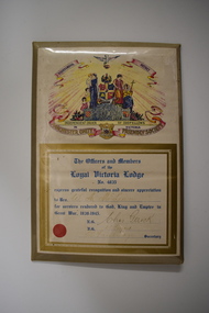 Warrnambool and District Historical Society Inc.
Certificate, Loyal Victoria Lodge, mid 1940s
The Loyal Victoria Lodge was established in Warrnambool in1862. It was a Lodge connected with the Friendly Society Manchester Unity Independent Order of Oddfellows. Friendly Societies were established to give members assistance in times of illness and hardship and to offer insurance against such events. The MUIOOF had its origins in Manchester, England. The Warrnambool Lodge built the Oddfellows Hall in Koroit Street in 1869 and in 1872 it joined with other friendly societies and established the Friendly Societies Park in Koroit Street. The MUIOOF joined with the Australian Natives Association and today the new name in Australian Unity. No details are available on W. A. McLean but the certificate indicates that he served his country during World War Two.This certificate is of considerable interest as the Loyal Victoria Lodge was a pioneer friendly society in Warrnambool with its history going back to 1862. It is also a good example of the certificates given to Warrnambool residents who had rendered significant war time service in World War Two.Framed Certificate featuring text and a coloured picture. The picture includes: a dove, five scrolls, a laurel wreath surrounding a globe, three women in long dresses, three young children, two stylised flower beds, rays of light, a hill and four coats of arms. It is covered with clear plastic with a metal back and metal prop. WARRNAMBOOL DISTRICT INDEPENDENT ORDER OF ODDFELLOWS IN VICTORIA MANCHESTER UNITY FRIENDLY SOCIETY. The Officers and Members of the Loyal Victoria Lodge No. 4835 express grateful recognition and sincere appreciation to Bro. W. A. McLean for services rendered to God, King and Empire in Great War, 1939- 1945. N.G.Chas Gerock V.G. F.J. Toogood Rob Fairbridge Secretary. a circular red seal. -
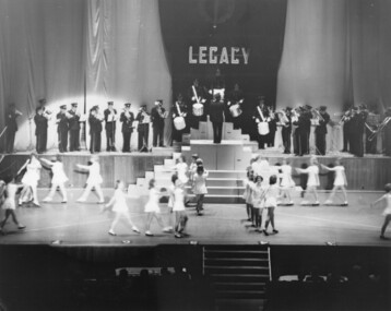 Melbourne Legacy
Photograph, Annual Demonstration 1963, 1963
Photos of the Melbourne Junior Legacy Annual Demonstration at the Melbourne Town Hall in September 1963. They include a scene of a canoe with junior legatees dressed as Native Americans. There are ballerinas dancing, and children marching and making formations. Also gymnastics demonstrations. Throughout the year Melbourne Legacy provided classes for Junior Legatees such as dancing, gymnastics and eurythmics, the Demonstration was an annual event to showcase their skills. Melbourne Legacy conducted Annual Demonstrations / Parades from 1928 through to the late 1970's, usually held at Melbourne Town Hall or Olympic Pool Stadium. The beautiful costumes were made by members of the Junior Legacy Mothers' Club and the Melbourne Legacy Wives' Association. A record of a Junior Legacy Demonstration.Black and white photo x 33 of the Annual Demonstration in 1963.junior legatee, annual demonstration, costumes, ballerinas -
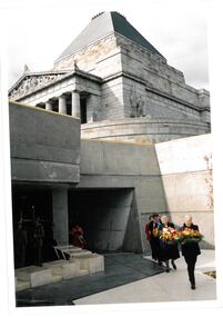 Melbourne Legacy
Photograph, Pilgrimage to the Shrine 2003, 2003
Wreath laying ceremony for Legacy widows at the Shrine of Remembrance. This is an annual event for Legacy widows at the start of Legacy Week, which is the first week in September. The photos show widows carrying wreaths to be laid in the Garden Courtyard. The plants in the Garden Courtyard have been selected because they are native to the Mediterranean countries in which Australians have served. An olive tree stands as a centrepiece, representing peace. This is the olive tree of peace that was planted by Legacy in 1973 to mark their golden jubilee. It was relocated to the new courtyard in 2002 when the Shrine was being redeveloped. From the film numbers it appears to be 2003 when David Ford was president (see also 00614, 00615).A record of a ceremony at the Shrine in 2003.Colour photo x 4 of a wreath laying ceremony in the courtyard at the Shrine.Printed on the back No.< > Clarendon Photos 0014 which is the frame numbers and place of processing. Negative numbers 1, 2, 3 and 5.widows, widows' sunday, pilgrimage, wreath laying ceremony -
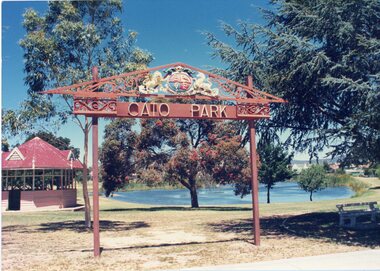 Stawell Historical Society Inc
Photograph, Cato Park -- Ornately Decorated Entrance -- 2 Photos -- Coloured
Two colour photo of Cato Park ornamental entrance gate that replaced the old entrance gates in c 1930's. The new entrance gates were donated by Mr. Frederick Cato and the park renamed from Victoria Park to Cato Park. The coat of Arms over the entrance gate was donated to Stawell Borough Council in 1926 by Mr. P. Whelan a native of Stawell. Mr. Whelan or better known as "Whelan the wrecker" demolished more than a quarter of central Melbourne buildings so new buildings could be erected on the old sites. The coat of arms came from "Burke & Wills Building" that once stood on the corner of Russell & Collins Street Melbourne. Two colour photographs of Cato Park ornamental entrance gate. Both photos are of similar views with the lake in the background and rotunda behind the gate. The main difference between the two photos is the colour of the rotunda roof, one red the other green. Judging by the increase in tree growth and pathway under the entrance gate the photo with the green rotunda roof must be the more recent photograph. stawell -
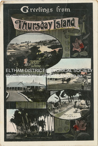 Eltham District Historical Society Inc
Photograph - Postcard, Postcard; Greetings from Thursday Island, c.1910s - c.1920s
[Five views of Thursday Island, including] Thursday Island from Military Barracks, The T.S. Hospital, Darnley Island Torres Straits, Main Street, Native Feast, [ca. 1917-1920] See https://catalogue.nla.gov.au/catalog/3117659 Dear Mum A few lines to let you know I've arrived at the top end of Aussie safely & now on my way down the coast towards Sydney. I'll be over on leave about the eighth Sept cheer up dont forget to send the suitcase about the second of Seot it will give me time to pack it then remember me to all & best love to yourself and Dad, your son Bill.This item, a souvenir from Thursday Island from between the wars (circa 1923) was brought home to Research, Victoria by Bill Teagle who was serving in the Royal Australian Navy (1919-1945). According to Bill's neice Valerie Waller (nee Feldbauer, daughter of Violet and Theodore 'Curly' Feldbauer), her Uncle Bill would always bring some sort of souvenir home from his travels for family members. The item ( along with a series of postcards from Japan of the Great Kanto Earthquake of 1 September 1923) was possibly given by Bill Teagle to his sister Margaret Rose (formerly Ingram) who later married Richard Edward (Eddie) Fielding in early 1948. (Eddie had been engaged to someone else before he went to war, but his fiancée broke it off before his return to Australia.) It was cared for by the Teagle/Fielding family for approximately one hundred years. It is of particular significance given the family's connection to the Eltham War Memorial through 'Curly' Feldbauer and the significance of that memorial to the local community and represents that despite the horrors of war, former friends then foes can become friends again.tom fielding collection, postcard, thursday island -
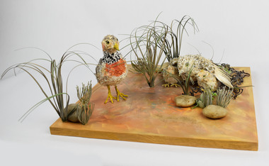 National Wool Museum
Artwork, other - Paper Taxidermy, Mary-Jane Walker, Plains Wanderer, 2020
The world’s most ecologically distinct bird lives in the native grasslands of Victoria - but only just. The plains-wanderer is a small bird that was once widespread across the grasslands of south-eastern Australia. Today there are fewer than 1000 mature birds in the wild. The plains-wanderer is under threat due to habitat loss caused by overgrazing, cropping and suburban sprawl. Unlike most other birds, female wanderers are larger and more colourful and the males take care of the chicks. They are only about 15cm tall and weigh between 40-80g for the male and 55-90g for the female. Their intricate plumage mirrors the colours of their grassland home so they blend in perfectly with their surroundings. The plains-wanderer’s origins date back to when Australia was part of the Gondwana supercontinent over 60 million years ago. They are so biologically distinct that their extinction would result in the loss of a branch of the tree of life. A fussy grass dweller, they like neither too much nor too little grass. That is where sheep grazing can help. After years of low numbers in Victoria, plains-wanderer populations have been increasing in Terrick Terrick National Park in north west Victoria, as sheep grazing maintains the grass in the park at a suitable level. With the right management, this ecologically important bird species is continuing to survive in the native grasslands of Victoria. Managing these habitats for the plains-wanderer can also support the conservation of many other threatened plant and animal species. Object: Nest of plains-wanderers by Mary-Jane Walker, 2020. Outer made from upcycled paper, internal structure steel. Nest of plains-wanderers by Mary-Jane Walker, 2020. Outer made from up cycled paper, internal structure steel. native grasslands, plains-wanderer, terrick terrick national park -
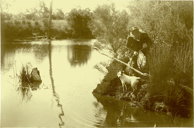 Kew Historical Society Inc
Photograph, J F C Farquhar, Ratting on the Yarra, 1891
At the beginning of the 1890s, the Kew businessman and Town Councillor, Henry Kellett, commissioned J.F.C. Farquhar to photograph scenes of Kew. These scenes included panoramas as well as pastoral scenes. The resulting set of twelve photographs was assembled in an album, Kew Where We Live, from which customers could select images for purchase.The preamble to the album describes that the photographs used the ‘argentic bromide’ process, now more commonly known as the gelatine silver process. This form of dry plate photography allowed for the negatives to be kept for weeks before processing, hence its value in landscape photography. The resulting images were considered to be finely grained and everlasting. Evidence of the success of Henry Kellett’s venture can be seen today, in that some of the photographs are held in national collections.It is believed that the Kew Historical Society’s copy of the Kellett album is unique and that the photographs in the book were the first copies taken from the original plates. It is the first and most important series of images produced about Kew. The individual images have proved essential in identifying buildings and places of heritage value in the district.In Farquhar’s close-up portrait of the rat catcher and his dog, the photographer excludes any extraneous data that otherwise might have provided a spatial or motivational context. The contemporary or the present day viewer is required to construct a narrative to explore or understand what is occurring. The title of the picture might incline a viewer to believe that what they see is an exercise in vermin control, and that the rat concerned might be an introduced black or brown rodent. A more likely scenario is that the rat catcher is focussed on catching ‘rakali’, a native water-rat once widely trapped for its fur. The trapping of rakali for use in the manufacture of fashionable clothing accelerated as introduced furs such as musquash became more expensive. It was not until 1938 that rakali were granted protected status.Ratting on the Yarrakew illustrated, kew where we live, photographic books, henry kellett, yarra river -
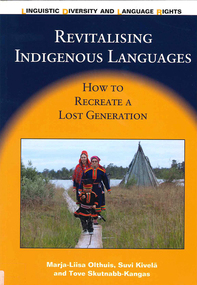 Victorian Aboriginal Corporation for Languages
Book, ?Marja-Liisa Olthuis et al, Revitalising Indigenous languages : how to recreate a lost generation, 2013
The book tells the story of the Indigenous Aanaar Saami language (around 350 speakers) and cultural revitalisation in Finland. It offers a new language revitalisation method that can be used with Indigenous and minority languages, especially in cases where the native language has been lost among people of a working age. The book gives practical examples as well as a theoretical frame of reference for how to plan, organise and implement an intensive language programme for adults who already have a professional training. It is the first time that a process of revitalisation of a very small language has been systematically described from the beginning; it is a small-scale success story. The book finishes with self-reflection and cautious recommendations for Indigenous peoples and minorities who want to revive or revitalise their languages.Maps, colour photographsnative language studies, bilingual education, casle project, saami, language revival