Showing 15618 items
matching north road
-
 Eltham District Historical Society Inc
Photograph, Birch Cottage, Eltham-Yarra Glen Road, c.1970, 1970
... this residence on the north side of the road. It was totally remote. GC... this residence on the north side of the road. It was totally remote. GC ...GC advised that when they first arrived in Eltham in the late 1960s, he would enjoy driving out to Yarra Glen. The Eltham-Yarra Glen road was unmade at the time. He passed this residence on the north side of the road. It was totally remote. GC found the juxtaposition of this little cottage with its surburban wire gate out in the remoteness of the landscape intriguing. Since then the road has been reconstructed and diverted away from the cottage which is now owned by Parks Victoria.Digital TIFF file Scan of 35mm Ilford HP4 black and white transparencyIlford HP4birch cottage, christmas hills, early settlers, edwin samuel birch, eltham-yarra glen road, honor mary birch, honor mary williams, john hill, watsons creek -
![Photograph - Digital image, Willis Vale [3], 1878c](/media/collectors/4f729f5697f83e03086015b8/items/54fd5aeb2162f10d30c0aed5/item-media/54fd5b042162f10d30c0b12d/item-fit-380x285.jpg) Greensborough Historical Society
Greensborough Historical SocietyPhotograph - Digital image, Willis Vale [3], 1878c
... in 1964 when a fire originating from North Plenty Gorge - Kurrak... North Plenty Gorge - Kurrak Road - was lit by two teenage boys ...Ellen and Charles Partington at Willis Vale: House built by Edward Maygar, Robert Whatmough lived there mid 19th century and later sold to Partington family. It was located on the Plenty River at Partington's Flat Greensborough. Land use included farming and orchards. The derelict Willis Vale house was destroyed in 1964 when a fire originating from North Plenty Gorge - Kurrak Road - was lit by two teenage boys and made its way several kilometres down to Partington's Flat Greensborough.Home of the Partington familyDigital copy of black and white photograph.charles partington, willis vale, ellen partington -
 Eltham District Historical Society Inc
Photograph, Birch Cottage, Eltham-Yarra Glen Road, c.1970, 1970
... this residence on the north side of the road. It was totally remote. GC... this residence on the north side of the road. It was totally remote. GC ...GC advised that when they first arrived in Eltham in the late 1960s, he would enjoy driving out to Yarra Glen. The Eltham-Yarra Glen road was unmade at the time. He passed this residence on the north side of the road. It was totally remote. GC found the juxtaposition of this little cottage with its surburban wire gate out in the remoteness of the landscape intriguing. Since then the road has been reconstructed and diverted away from the cottage which is now owned by Parks Victoria.Digital TIFF file Scan of 35mm Ilford HP4 black and white transparencyIlford HP4birch cottage, christmas hills, early settlers, edwin samuel birch, eltham-yarra glen road, honor mary birch, honor mary williams, john hill, watsons creek -
 Southern Sherbrooke Historical Society Inc.
Photograph - Tantallon, Douglas farm at Menzies Creek/Emerald
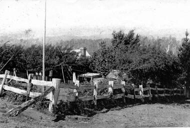
... on the north side of Ridge Road. The photo shows a corner of a post... owned by Norah and Percy Douglas, situated on the north side ...Black and White photograph of 'Tantallon', the Menzies Creek/Emerald Farm owned by Norah and Percy Douglas, situated on the north side of Ridge Road. The photo shows a corner of a post and rail fence enclosing a small farm paddock. Behind a row of trees, a brick chimney and part of a roof can be seen, presumably the main farmhouse. Timbered hills can be seen in the background. The photo appears to be taken looking north. See also VSSH0046 for more details. -
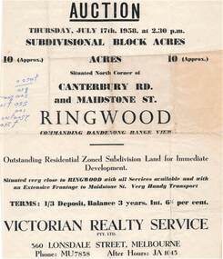 Ringwood and District Historical Society
Flyer - Land Auction Sale, Ten Acres, Maidstone Street Ringwood - 1958
... , 1958, (Approx.) 10 Acres, north corner of Canterbury Road... 17th, 1958, (Approx.) 10 Acres, north corner of Canterbury Road ...Double sided page advertising Auction, Thursday, July 17th, 1958, (Approx.) 10 Acres, north corner of Canterbury Road and Maidstone Street, Ringwood. Agents - Victorian Realty Service Pty.Ltd., 360 Lonsdale Street, Melbourne, Phone MU7858, After Hours JA1045. Reverse side shows map of proposed subdivision by K.J. Noonan & Co., Surveyors & Engineers, 495 St.Kilda Rd, Melbourne, marked subject to approval of all interested statutory authorities.Residential zoned subdivision land for immediate development. Extensive frontage to Maidstone Street. Accompanying handwritten annotation "10 acres offered as a whole, later re-subdivided". -
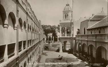 Melbourne Legacy
Postcard, Orange Hotel Oostkant, Soerabaia, Java, c1915
... . W. Elsum. 30 Station Road. North Williamstown. Victoria.... 30 Station Road. North Williamstown. Victoria. Australia ...This postcard has a photo of the Orange Hotel Oostkant, Soerabaia, Java taken around 1915 (now known as Surabaya in Indonesia). Perhaps the sender, Lee, was a returning serviceman from World War One coming back to Australia via Indonesia and this was a card home to his family.A record of postal correspondence in 1915. Postcards were a very common form of communication in the first World War. This type of souvenir would have been familiar to the first Legatees as they had served in World War 1.Glossy postcard with photo of the Orange Hotel in Java.Handwritten: "Dear Katy, Am going to spend a week or so in Java. Hope you are all well. I am feeling very fit, Lee. / Mrs. W. Elsum. 30 Station Road. North Williamstown. Victoria. Australia. " Printed on the photo - 2 / Orange Hotel Oostkant, Soerabaia, Java. / Photo. KURKDJIAN LTD, SOERABAIA.Printed on card - POST CARD / The Address only to be written here Stamp - Nederlandsch-Indie, 5 CENT Postmark - SOERABAJA 16.7.15 souvenir, war correspondence -
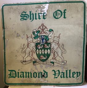 Greensborough Historical Society
Sign - Boundary Sign, Shire of Diamond Valley, Shire of Diamond Valley boundary sign, 1990s
... ; at Yan Yean Road north of Bannons Lane; 2 on Plenty Road near... Glen Station; at Yan Yean Road north of Bannons Lane; 2 ...The Shire of Diamond Valley was a Local Government Area located about 20 kilometres northeast of Melbourne. The shire covered an area of 74.38 square kilometres and existed from 1964 until 1994. This example of a Boundary Sign was one of many located on the edge of the Shire e.g. at Wattle Glen Station; at Yan Yean Road north of Bannons Lane; 2 on Plenty Road near Larundel and Bundoora Primary School; one on the Para Road bridge; on Wattletree Road Eltham and on Kurrak Road Yarrambat. According to a former Shire employee, the signs were often stolen as quickly as they were replaced. This sign was removed when the Shire of Diamond Valley was dissolved in 1994 and is signed by a Shire employee, giving it strong provenance.Painted metal sign, cream background with green text and Shire of Diamond Valley crest.Inscribed in felt tip pen on back of sign: SDV: from Nov 1964 to 1994. 30 years. Ron Middleton, By-laws Officer and Ranger, from 9/84 to Nov 94 [signed] R. Middletonshire of diamond valley, boundary signs -
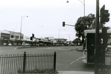 Whitehorse Historical Society Inc.
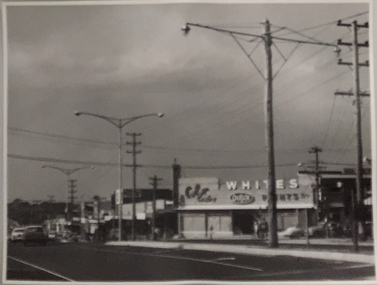
Photograph, Whitehorse Road, Mitcham, 2000
... East along North side of Whitehorse Road towards Mitcham Road...Whitehorse Historical Society Inc. 2-10 Deep Creek Road ...Produced as one of a series of 24 prints commissioned by Nunawading & District Historical Society -|Theme: Intersections of Mitcham and Nunawading 2000/2001.|See also Series by P. Simmenauer on the same theme. Black and white photograph - print and negative looking East along North side of Whitehorse Road towards Mitcham Road intersection from corner of Station Street. Featured from L-R shops include Stan Russell Mens Clothing; Top floor Wing Chum Kung Fu Academy (Martial Art); Lower floor: Florist, Bryson Office Supplies, Mitcham Pharmacy and Medical Centre; Road sign - Mitcham Road - Vermont; across intersection - sign for 'Bristol Paints'.whitehorse road, mitcham, stan russell menswear, wing chum kung fu academy, florists, mitcham pharmacy, mitcham medical centre, bristol paints, bryson office supplies -
 Greensborough Historical Society
Painting - Digital image, Barn at Willis Vale, 1920c
... from North Plenty Gorge - Kurrak Road - was lit by two teenage... a fire originating from North Plenty Gorge - Kurrak Road ...Painting of a barn at Willis Vale. 'Willis Vale' was owned and farmed by the Partington family from the 1870s. The derelict Willis Vale house was destroyed in 1964 when a fire originating from North Plenty Gorge - Kurrak Road - was lit by two teenage boys and made its way several kilometres down to Partington's Flat Greensborough. Gary Partington thought the barn was probably associated with the bull yard. (Note: Only some abandoned stumps existed when Gary was very young in the mid to late 1940s) Digital copy of painting.willis vale, partington family -
 Eltham District Historical Society Inc
Negative - Photograph, Main Road, Eltham, c.1910
... Main Road looking north from Pitt Street. On the far left... melbourne Main Road looking north from Pitt Street. On the far left ...Main Road looking north from Pitt Street. On the far left is Mrs Mary Ann Morris' house and shop and Hill's House. William Morris was the publican for the Eveyn Hotel which was on the opposite corner of Pitt Street and Main Road. Also believed to be the Scarce house at some stage, Mrs Emily Scarce was President of the Australian Women's National League. On the right is Webster's then the Commercial Bank of Australia branch, the Methodist Church just behind it on John Street. To the immediate right out of visibility is Watson's Eltham Hotel.This photo forms part of a collection of photographs gathered by the Shire of Eltham for their centenary project book,"Pioneers and Painters: 100 years of the Shire of Eltham" by Alan Marshall (1971). The collection of over 500 images is held in partnership between Eltham District Historical Society and Yarra Plenty Regional Library (Eltham Library) and is now formally known as the 'The Shire of Eltham Pioneers Photograph Collection.' It is significant in being the first community sourced collection representing the places and people of the Shire's first one hundred years.Digital image 4 x 5 inch B&W Negshire of eltham pioneers photograph collection, eltham, main road, scarce house, cba bank, gas lamp, hill's house, hostelry, john street, methodist church, pitt street, websters house, mrs morris shop -
 Melbourne Tram Museum
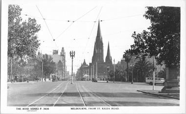
Postcard, Rose Stereograph Co, "Melbourne from St Kilda Road", late 1930s
... Kilda Road", looking north from just south of Alexandra Avenue...Melbourne Tram Museum 8 Wallen Road Hawthorn melbourne Rose ...Rose Series postcard No. P 3636, titled "Melbourne from St Kilda Road", looking north from just south of Alexandra Avenue. Note how the tram tracks are widened to pass around the center of the road light standard which appears to be marked as a tram stop. In front of the photo, a tram crossover can be seen. There is a tour bus parked at the start of Alexandra Avenue. See item 8044 for a similar view. The Edmund Fitz Gibbon Memorial is on the right in its original position in St. Kilda Road.Yields information Swanston Street and St Kilda Road in the late 1930s.Postcard - printed real photograph with Rose Stereograph Co. name on the rear.tramways, trams, st kilda road, alexandra ave -
 Ringwood and District Historical Society
Document, 1926 Land Survey drawing of the area surrounding 1-5 City Road, Ringwood
... was between Haig Street in the north, City Road in the south, Wantirna... Road Ringwood North melbourne Hand-drawn survey of what is now ...Drawing on parchmentHand-drawn survey of what is now 1-5 City Road, Ringwood. Drawn by K Arndt, licensed surveyor, 237 Queen Street, Melbourne Tel 5118 on 25 September 1926. The block of land in question was 2 roods, 21 and 8/10 perches in size. The location was between Haig Street in the north, City Road in the south, Wantirna Road in the west and Victoria Road in the east. The Good Shepherd Retirement Village (Lutheran) now occupies the land. The drawing shows a number of existing weatherboard houses, fences and frontage sizes. A number of named roads were defined but no longer exist, these were Duffy Street (to the west), Evans Street (east) and Victoria Street (further east). Ireland Street still exists in the south. -
 Warrnambool and District Historical Society Inc.
Document - Warrnambool City Council Preliminary Report Industrial Estate West Warrnambool, E Johnson, 9 March 1973
... owned land in West Warrnambool bounded on the North by McMeekin... owned land in West Warrnambool bounded on the North by McMeekin ...This preliminary report relates to 32½ acres of council owned land in West Warrnambool bounded on the North by McMeekin Road, on the East by Scott Street, on the South by Evans Street and on the West by the rear boundaries of properties facing Landmann and Granter Streets. In 2010, West Warrnambool was the largest of Warrnambool’s existing industrial areas, comprising approximately 109ha of industrial zoned land, the majority of which (101ha) is zoned IN1Z, with the remainder zoned INZ3. The area comprises a mixture of lot sizes supporting a diverse mix of industries. Larger parcels are occupied by the abattoirs, scrap metal industries, freight, the Council Depot and storage. Smaller lots are occupied by smaller manufacturers and wholesalers and service industries. [Ref: Warrnambool Industrial Land Use Review. Mesh Pty Ltd July 2010]This document is a preliminary report prepared by the Warrnambool City Council Engineer in March 1973 and provides an example of the planning process undertaken to develop one of Warrnambool's industrial areas. It contains details and costings of the proposed subdivision. Two foolscaps size pages of typewritten information. A detailed topographical map of the area with areas highlighted in blue, red, green, blue and purple pen.warrnambool city council, west warrnambool, industrial estate -
 Eltham District Historical Society Inc
Photograph, Liz Pidgeon, Heritage Excursion; Maroondah Aqueduct, 3 September 2016, 3 September 2016
... at the junction of Allendale Road with Godber Road and Zig Zag Road North...Godber Road, Eltham North, Victoria, Australia... at the junction of Allendale Road with Godber Road and Zig Zag Road North ...Heritage Excursion - Maroondah Aqueduct Walk - Saturday 3rd September The Maroondah Aqueduct was once a major link in Melbourne’s water supply system. It was built between 1886 and 1891 to transfer water from the Watts River near Healesville to the Preston Reservoir. It was 66 km in length, made up of 41 km of open channel, 10 km of tunnel through hills and 15 km of pipeline across stream valleys known as inverted siphons. The section of the aqueduct through the Eltham area has been abandoned since the 1980s but the open channel has largely been retained. A recreational path follows the aqueduct reserve. For our excursion on 3rd September we intend to walk along the section of the aqueduct adjacent to Allendale Road. This is a section not visited on previous excursions and includes the transition from open channel to the inverted siphon across the Diamond Creek valley. Apart from the aqueduct itself the main feature of the walk is the extensive views across Eltham North and Diamond Creek. Along the way we will talk about the history of the aqueduct and the area. This easy walk is about 3 km return and will take 2 to 2.5 hours. It will start at 2pm at the junction of Allendale Road with Godber Road and Zig Zag Road North, officially Diamond Creek, but on the northern boundary of Eltham. (Melway ref.12 B10). Newsletter No., 229, August 2016 Brick bridge on Parsons road, Eltham North over the aqueduct on the aqueduct trail. Born Digitalmaroondah aqueduct, eltham north, activities, eltham district historical society, heritage excursion, parsons road, bridges, aqueduct trail -
 Ringwood and District Historical Society
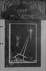
Booklet, Norwood High School 1958 Magazine
... . Although a site between Mullum and Wonga Roads, North Ringwood, has... Road Ringwood North melbourne Subsequent Norwood High School ...Typewritten magazine - 1958 - first year of Norwood High School, Ringwood, Victoria.non-fiction -
 Whitehorse Historical Society Inc.
Photograph, Mitcham R.S.L. Memorial Hall, 13/06/1986 12:00:00 AM
... 2 Coloured photos of Mitcham R.S.L. Memorial Hall, north..., north eastern corner Whitehorse Road and McDowall Street ...2 Coloured photos of Mitcham R.S.L. Memorial Hall, north eastern corner Whitehorse Road and McDowall Street. The Hall is comprehensively documented in the society's archives. See also NP1068. War Memorial in foreground Buildings shown to left of hall occupy a vacant block that reached almost to Mitcham Road. Barrie Gracie's Milk Bar and Mr. Holly's shoe repairs filled the remaining space. The large vacant space was used for impromptu cricket and football games and was akso the location for the circuses the regularly visited Mitcham.mitcham memorial hall, war memorials, soldiers memorial, mitcham -
 Kew Historical Society Inc
Photograph, Stuart Tompkins Studio, Electricity Supply Poles, Warrigal Road, Ashwood, 1965
... Road and High Street South, Ashwood looks north along High.... South of High Street Road looking north. Wooden and steel poles... north along High Street Road. The intent of the photograph ...Research provided by Stuart Tompkins Studio, Box Hill, into alternatives for median strip street lighting to be used in Burke Road, Kew. The photographers identified variants in different suburbs appropriate to Kew's needs.The series from which the photograph is drawn provides a snapshot by a commercial photographic studio of each named vicinity in 1965 as well as providing examples of public works infrastructure being commissioned by local government in the 1960s. The photos originally formed part of the Engineering Department's files in the City of Kew before being donated to the kew Historical Society.Electricity Supply Poles, Warrigal Road, Ashwood, 1965. Stuart Tompkins Studio provided this photograph for the Kew City Council. The photograph, taken at the intersection of Warrigal Road and High Street South, Ashwood looks north along High Street Road. The intent of the photograph was to provide the Council with models of electricity supply poles. In the photo, wooden and steel poles can be seen in the median strip. The photograph also includes the shops bordering High Street Road during this period. [There are three copies of this photograph in the Collection.]. Typed inscription on reverse: "Electricity Supply Poles. Photographed for Kew City Council 8/2/65. No.4 Warrigal Road - Ashwood. South of High Street Road looking north. Wooden and steel poles with different brackets in median strip." Studio stamp: "Stuart Tompkins Studio. 547 Station Street, Box Hill. WX1439."electric light poles, public works -- 1960s, civic infrastructure -- 1960s -
 Kew Historical Society Inc
Photograph, Stuart Tompkins Studio, Electricity Supply Poles, Warrigal Road, Ashwood, 1965
... Road and High Street South, Ashwood looks north along High.... South of High Street Road looking north. Wooden and steel poles... north along High Street Road. The intent of the photograph ...Research provided by Stuart Tompkins Studio, Box Hill, into alternatives for median strip street lighting to be used in Burke Road, Kew. The photographers identified variants in different suburbs appropriate to Kew's needs.The series from which the photograph is drawn provides a snapshot by a commercial photographic studio of each named vicinity in 1965 as well as providing examples of public works infrastructure being commissioned by local government in the 1960s. The photos originally formed part of the Engineering Department's files in the City of Kew before being donated to the kew Historical Society.Electricity Supply Poles, Warrigal Road, Ashwood, 1965. Stuart Tompkins Studio provided this photograph for the Kew City Council. The photograph, taken at the intersection of Warrigal Road and High Street South, Ashwood looks north along High Street Road. The intent of the photograph was to provide the Council with models of electricity supply poles. In the photo, wooden and steel poles can be seen in the median strip. The photograph also includes the shops bordering High Street Road during this period. [There are three copies of this photograph in the Collection.]. Typed inscription on reverse: "Electricity Supply Poles. Photographed for Kew City Council 8/2/65. No.4 Warrigal Road - Ashwood. South of High Street Road looking north. Wooden and steel poles with different brackets in median strip." Studio stamp: "Stuart Tompkins Studio. 547 Station Street, Box Hill. WX1439."electric light poles, civic infrastructure - 1960s, public works -- 1960s -
 Kew Historical Society Inc
Photograph, Stuart Tompkins Studio, Electricity Supply Poles, Warrigal Road, Ashwood, 1965
... Road and High Street South, Ashwood looks north along High.... South of High Street Road looking north. Wooden and steel poles... north along High Street Road. The intent of the photograph ...Research provided by Stuart Tompkins Studio, Box Hill, into alternatives for median strip street lighting to be used in Burke Road, Kew. The photographers identified variants in different suburbs appropriate to Kew's needs.The series from which the photograph is drawn provides a snapshot by a commercial photographic studio of each named vicinity in 1965 as well as providing examples of public works infrastructure being commissioned by local government in the 1960s. The photos originally formed part of the Engineering Department's files in the City of Kew before being donated to the kew Historical Society.Electricity Supply Poles, Warrigal Road, Ashwood, 1965. Stuart Tompkins Studio provided this photograph for the Kew City Council. The photograph, taken at the intersection of Warrigal Road and High Street South, Ashwood looks north along High Street Road. The intent of the photograph was to provide the Council with models of electricity supply poles. In the photo, wooden and steel poles can be seen in the median strip. The photograph also includes the shops bordering High Street Road during this period. [There are three copies of this photograph in the Collection.]. Typed inscription on reverse: "Electricity Supply Poles. Photographed for Kew City Council 8/2/65. No.4 Warrigal Road - Ashwood. South of High Street Road looking north. Wooden and steel poles with different brackets in median strip." Studio stamp: "Stuart Tompkins Studio. 547 Station Street, Box Hill. WX1439."electric light poles, public infrastructure -- 1960s, civic works -- 1960s -
 Eltham District Historical Society Inc
Photograph - Aerial Photograph, Landata, Research, Vic, Apr. 1972
... by Allendale Road to north, Thompson Crescent to south, Eltham College... by Allendale Road to north, Thompson Crescent to south, Eltham College ...Centred on present day Maroong Drive, Research bounded by Allendale Road to north, Thompson Crescent to south, Eltham College to east and Parsons Road to west. Historic Aerial Imagery Source: Landata.vic.gov.au Aerial Photo Details: Project No :985 Project : MELBOURNE 1972 Run : 26 Frame : 193 Date : 04/1972 Film Type : B/W Camera : RC10 Flying Height : 5700 Scale : 9600 Film Number : 2636 GDA2020 : 37°42'04"S, 145°10'33"E MGA2020 : 339187, 5825794 (55) Melways : 22 F1 (ed. 42)aerial photo, neil webster collection, 1972-04, allendale road, eltham, eltham barrel, eltham college, maroong drive, melway 22f1, parsons road, research (vic.), thompson crescent -
 Eltham District Historical Society Inc
Photograph - Aerial Photograph, Landata, Eltham, Vic, Apr. 1972
... bounded by Progress Road to north, Brougham Street to south, Bible... bounded by Progress Road to north, Brougham Street to south, Bible ...Centred on present day Ryans Road at Sandra Avenue, Eltham bounded by Progress Road to north, Brougham Street to south, Bible Street to east and Outlook Crescent to west. Historic Aerial Imagery Source: Landata.vic.gov.au Aerial Photo Details: Project No :985 Project : MELBOURNE 1972 Run : 27 Frame : 48 Date : 04/1972 Film Type : B/W Camera : RC10 Flying Height : 5700 Scale : 9600 Film Number : 2636 GDA2020 : 37°42'41"S, 145°08'38"E MGA2020 : 336392, 5824574 (55) Melways : 21 H4 (ed. 42)aerial photo, neil webster collection, 1972-04, eltham, bible street, brougham steet, melway 21h4, outlook crescent, progress road, ryans road, sandra avenue, montmorency -
 Eltham District Historical Society Inc
Photograph - Aerial Photograph, Landata, Eltham, Vic, Apr. 1972
... , Eltham bounded by Nyora Road to north, Yarra River to south..., Eltham bounded by Nyora Road to north, Yarra River to south ...Centred on present day Mays Road at Stringybark Road, Eltham bounded by Nyora Road to north, Yarra River to south, Reynolds Road to east and Bible Street to west. Historic Aerial Imagery Source: Landata.vic.gov.au Aerial Photo Details: Project No :985 Project : MELBOURNE 1972 Run : 28 Frame : 209 Date : 04/1972 Film Type : B/W Camera : RC10 Flying Height : 5700 Scale : 9600 Film Number : 2635 GDA2020 : 37°43'33"S, 145°09'28"E MGA2020 : 337647, 5823013 (55) Melways : 22 B8 (ed. 42)aerial photo, neil webster collection, 1972-04, eltham, bible street, mays road, melway 22b8, nyora road, reynolds road, stringybark road, yarra river -
 Greensborough Historical Society
Photograph - Digital Image, Willis Vale, 1950c
... when a fire originating from North Plenty Gorge - Kurrak Road...Greensborough Historical Society 34A Glenauburn Road Lower ...House built by Edward Maygar, Robert Whatmough lived there mid 19th century and later sold to Partington family. It was located on the Plenty River at Partington's Flat Greensborough. The derelict Willis Vale house was vandalized later destroyed in 1964 when a fire originating from North Plenty Gorge - Kurrak Road - was lit by two teenage boys and made its way several kilometres down to Partington's Flat Greensborough. This photo was taken after the Partington's moved house in 1947 across the river where Alan built their new Alwyn house that had access to electricity.A pioneer home in Greensborough.Digital copy of black and white photograph.willis vale, partington family, robert whatmough, maygar family -
 Ballarat Tramway Museum
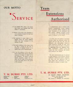
Pamphlet - Real Estate, T M Burke Pty Ltd, "Tram Extensions Authorised", 1936
... as authorised (16-7-1936) are: Keilor Road Essendon, High St North... as authorised (16-7-1936) are: Keilor Road Essendon, High St North ...Wal Jack collected tramway and railway items for his collection. This pamphlet gives details of the Melbourne Public Transport system - rail, tram and bus in late 1936. Issued by T M Burke Pty Ltd of 840 Collins St Melbourne, Real Estate agents, shows the extensive sub-divisions where land was available for purchase and notes the MMTB authorisation of new tram routes. Gives details of the T M Burke services. Routes shown as authorised (16-7-1936) are: Keilor Road Essendon, High St North Balwyn and Hawthorn Road East Brighton. Demonstrates a Real Estate Sales pamphlet.Pamphlet - four colours printed on cream coloured bond paper, folded vertically originally.letter, wal jack, buninyong, railway lines -
 Orbost & District Historical Society
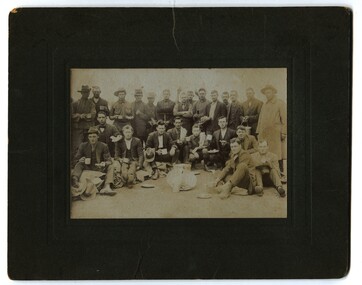
black and white photographs, September 1914
... Kilda Road and headed north up Sydney Road, only resting near... Kilda Road and headed north up Sydney Road, only resting near ...Broadmeadows was home to the major army training camp for the Australian Imperial Force. The land was previously known as Mornington Park. It was a wide field, suitable for military practice, including training for the Light Horse regiments. It is the current location of the Maygar Army Barracks on Camp Road in Broadmeadows. To reach the camp, soldiers marched from Victoria Barracks in St Kilda Road and headed north up Sydney Road, only resting near Fawkner Cemetery. Soldiers slept in tents and food was basic. Training was hard, but it did not prepare soldiers for a modern war with machine guns, gas, shells and aeroplanes – technology that did not exist in previous wars. Some men only completed a few months training before departing on troopships from Port Melbourne. Once overseas, some soldiers received further training in Egypt. It is likely that these men are associated with the Orbost district.This photograph is a reminder of the personal stories of those who were involved in WW1.Two copies of a black / white photograph on dark grey buff cards. The photos show a group of soldiers having a meal. Some are sitting on the ground with others standing behind them.on back of 989.1 - "Sept 14 Broadmeadows"w.w.1 broadmeadows-army-training-camp -
 Glen Eira Historical Society
Album - Album page, Hawthorn Road, Circa 1972
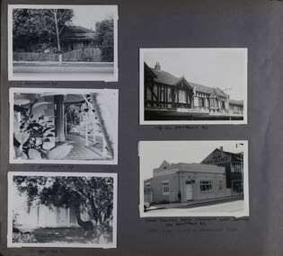
... 198 pages. 17 Hawthorn Road, North Caulfield...Hawthorn Road, Caulfield North, Melbourne, Victoria... 198 pages. 17 Hawthorn Road, North Caulfield ...This photograph is part of the Caulfield Historical Album 1972. This album was created in approximately 1972 as part of a project by the Caulfield Historical Society to assist in identifying buildings worthy of preservation. The album is related to a Survey the Caulfield Historical Society developed in collaboration with the National Trust of Australia (Victoria) and Caulfield City Council to identify historic buildings within the City of Caulfield that warranted the protection of a National Trust Classification. Principal photographer thought to be Trevor Hart, member of Caulfield Historical Society. Most photographs were taken between 1966-1972 with a small number of photographs being older and from unknown sources. All photographs are black and white except where stated, with 386 photographs over 198 pages. 17 Hawthorn Road, North Caulfield is a contributory building to HO14 Caulfield North and environs, Caulfield North - Heritage Precinct in the City of Glen Eira.Page 83 of Photograph Album with five portrait photographs of 3 different properties on Hawthorn Road. Addresses are handwritten underneath each property.Handwritten: 17 HAWTHORN ROAD [under top left photo] / 17 HAWTHORN ROAD [under middle left photo] / 17 HAWTHORN ROAD [under bottom left photo] / 158-162 HAWTHORN ROAD [under top right photo] // STATE SAVINGS BANK CAULFIELD WEST BRANCH / 144 HAWTHORN RD / WEST SIDE - SOUTH OFF BALACLAVA ROAD [under bottom right photo] / 83 [bottom left] trevor hart, caulfield, hawthorn road, verandahs, houses, shops, banks, state savings bank, caulfield west, caulfield north, tudor style, victorian style -
 Glen Eira Historical Society
Album - Album page, Grimwade House, Orrong Road, Circa 1972
... House", is situated at no. 67 Balaclava Road, Caulfield North...67 Balaclava Road, Caulfield North, Melbourne, Victoria... House", is situated at no. 67 Balaclava Road, Caulfield North ...This photograph is part of the Caulfield Historical Album 1972. This album was created in approximately 1972 as part of a project by the Caulfield Historical Society to assist in identifying buildings worthy of preservation. The album is related to a Survey the Caulfield Historical Society developed in collaboration with the National Trust of Australia (Victoria) and Caulfield City Council to identify historic buildings within the City of Caulfield that warranted the protection of a National Trust Classification. Principal photographer thought to be Trevor Hart, member of Caulfield Historical Society. Most photographs were taken between 1966-1972 with a small number of photographs being older and from unknown sources. All photographs are black and white except where stated, with 386 photographs over 198 pages. From Victorian Heritage Database citation HO54 Grimwade House, former Harleston stables, outbuilding, garden, gate and Picconia excelsa tree. https://vhd.heritagecouncil.vic.gov.au/places/35573 as at (28/10/2020) ''Harleston'', now "Grimwade House", is situated at no. 67 Balaclava Road, Caulfield North, at the Orrong Road corner. It was built for Frederick, later Sir Frederick, Grimwade, to the design of architect Thomas Watts in 1875. Today the complex has been incorporated in the Melbourne Grammar Junior School campus. It retains not only the main house but also the stables and mature garden setting with driveway and gates. It is historically, aesthetically and socially significant.From Victorian Heritage Database citation HO54 Grimwade House, former Harleston stables, outbuilding, garden, gate and Picconia excelsa tree. https://vhd.heritagecouncil.vic.gov.au/places/35573 as at (28/10/2020) It is historically significant (Criterion A) as the former home of prominent business man, speculator and benefactor, Sir Frederick Grimwade. Both Grimwade and his house are exemplars of the commercial enterprise of the Boom period and the amassing of personal fortunes with which it is associated. It is aesthetically significant (Criterion E) as an imposing yet stately large house of its time, the classic Italian form with comer verandah terminated by projecting wings being most distinctively seen in this instance. It is enhanced not only by the garden setting but also by the delicate cast iron verandah spandrels, stained glass work and stencilled ceiling in the music room. It is socially significant (Criterion G) on account of the value placed on it by the community associated with the Melbourne Grammar Junior School since its inception on this site in 1911.Page 154 of Photograph Album with five photographs (4 landscape and one portrait) including Grimwade House, gates and a tram shelter.Handwritten: Grimwade House (Melbourne Grammar Prep School) / incorporating "Harleston" Orrong Rd. S.E cnr Balaclava Rd [top right] / 154 [bottom right]trevor hart, verandah, porch, slate roof, garden, grimwade house, grimwade, harleston, sir frederick grimwade, thomas watts, orrong road, balaclava road, melbourne grammar, melbourne grammar junior school, italianate, cast iron verandah spandrels, stained glass, stencilled ceiling, mgs, m.g.s, school, grimwade family, jessie grimwade, gates, palisade style fence, cast iron spears, stone plinths, melbourne grammar prep school, victorian style, cast iron work, caulfield north, gardens, cars, tram services, outbuildings, stables, trees, picconia excelsa tree -
 Ringwood and District Historical Society
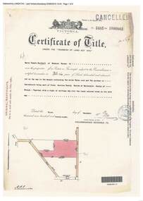
Document, Certificate of Title - Harry Temple Marshall, Wesburn Farmer, Vic. - part of Crown Section 20, Parish of Warrandyte, County of Evelyn - 1928
... Road), both north of Plymouth Road, Ringwood, Vic. Transfers... Road), both north of Plymouth Road, Ringwood, Vic. Transfers ...A4 copies of Landata Victoria Historical Search documents - Vol 5485 Fol 1096803. Harry Temple Marshall is now the proprietor of an Estate in Fee-simple subject to the Encumbrances notified hereunder ... 10 acres 3 roods 10 perches or thereabouts, together with a right of carriage way over roads coloured brown. Subdivision map includes un-named roads - western side is Wonga Road (later Warranwood Road), and eastern side is Grandview Grove (later Bemboka Road), both north of Plymouth Road, Ringwood, Vic. Transfers include Harold Claude Howship, 1st December, 1928 James Bell McAlpin, 26th March, 1939. -
 Whitehorse Historical Society Inc.
Photograph, Nunawading Brownie Guiders in Mitcham Shopping Centre, Late 1950s - Early 1960s
... on the north side of Whitehorse Road, west of Mitcham Road.The traders...Whitehorse Historical Society Inc. 2-10 Deep Creek Road ...Black and white photo of Nunawading Brownie Guiders at a parade in Mitcham Shopping Centre. Photo shows the Mitcham shops on the north side of Whitehorse Road, west of Mitcham Road.The traders shown in the photo, left to right, Claude Richards-Draper; D.G.Williamson - Fruiterer; Bob Dorien - Chemist in same building as Williamson; Hay and Corn Store - ???; and Norman & Sons-Grocer.Across Mitcham Road is Barrie George - Milk Bar; Fish Shop- ??? and Ken Herbert - Grocer; the Mitcham Memorial Hall is on the east side.It is estimated that the photo was taken in the late 1950s or early 1960s.richards, claude, dorien, bob, williamson, d.g., norman & sons, george, barrie, herbert, ken, fish shops, mitcham memorial hall, gardiner, shirley, floyd, peg, quick, judith, elsworth, jean, lynette, brown, evelynne, hogben, pam, sue, yarrow, erica