Showing 11471 items matching "maps "
-
 Healesville Sanctuary Heritage Centre
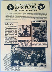
Flyer - program, Circa 1994
The brochure features newspaper articles and snapshots of Healesvile Sanctuary in the 1930's. This is a 4 page pamphlet printed on yellow A3 paper and folded in half. It features activities and information relating to the 60th anniversary of the Healesville Sanctuary. Print is dark green. The back page has a map and opening times of the various exhibits and "Meet the Keeper" times. Includes 3 photographs from old newspapers.healesville-sanctuary, holiday-program, 60th-anniversary, official-opening, map -
 National Vietnam Veterans Museum (NVVM)
Journal, C of A Green Binder
Binder containing: Article, Clipping of Warrant Officer R. Harris. 4 maps of verious locations in Vietnam. Citation. List of US personnel. 20 pages of handwritten notes and diagrams. 15 pages of typed notes marked Confidential. 25 pages stamped with Confidential and hand written by Robert G. Harrisbinder, vietnam -
 Ballarat RSL Sub-Branch Inc.
Memorabilia - Framed
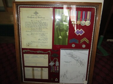
Geoffrey Ronald COOK Certificate of Discharge; Photograph of himself in uniform; a set of 4 WW2 Medals; 1 x only colour patch; I x Chevron blue years of service; 1x set of gold Chevrons; 2x New Guinea coins (with hole in centre); Pencil drawing of Map - Msecond world war (ww2), 1939 - 1945, collectables, ballarat rsl, ballarat -
 Bendigo Historical Society Inc.
Booklet - The Bendigo Naturalist
The Bendigo Naturalist (a set of 5). The Journal of the Bendigo Field Naturalist Club. Vol 5 Nos. 1&2, Vol 6 Nos. 1&2, Vo; 7 No. 2 Each booklet illustrated with B&W photos and maps. Featuring articles and reports on flora and fauna subjects of the Bendigo Area. bendigo naturalist, widlife, flora & fauna -
 Kew Historical Society Inc
Document - Urban Planning Document, City of Kew, City of Kew : Minimum Size of Allotment Required, 1945-1955
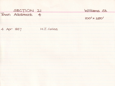
A document outlining the relevant by-laws produced by the City Of Kew to regulate the minimum size of allotments in Barkers Road, Burke Road, Cotham Road, Glenferrie Road and Studley Park Road, as well as in other streets more generally. The by-laws specify the size of allotments in which single unit dwellings, attached houses and maisonettes, and flats could be built. In the ‘main streets’ a minimum land area for single unit dwellings was 8,100 square feet, with an average frontage of 60’ and a depth of 135’. In other streets this was reduced to an overall size of 6,250 square feet, with an average dimensions of 50’ x 125’. In specifying the land area required by flats, different sizes were regulated for the construction of between two and six flats. Six flats at the time when the regulations were passed must have been the upper limit permitted. Understanding the size of land listed in imperial measurements can be a challenge. Within Australia, the so-called quarter acre block was approximately 11,000 square feet. Those specified in the by-laws would appear to be smaller. The document was pasted on the reverse of a subdivision plan in the collection.This is a rare (undated) document produced by the City of Kew defining how subdivision within the municipality should occur. The document was created to constrain unbridled speculation in subdivisions in the various parts of Kew and East Kew.Undated typed document, issued by the City of Kew (1921-1994) indicating the minimum size of allotment required in Barkers Road, Burke Road, Cotham Road, Glenferrie Road and Studley Park Road. The document is mounted on board and waterstained. It was presumably used by a real estate agent. [Formerly catalogued as MAP.0066].city of kew - by-laws and regulations, subdivisions - kew - studley park -
 Kilmore Historical Society
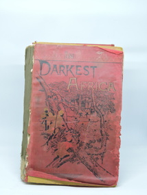
In Darkest Africa, In Darkest Africa or the Quest Rescue and Retreat of EMIN Governor of Equatoria, 1890
Late Victorian travels, skirmishes and adventures in Africa. Colonial edition not for sale in Great Britain.Brown cardboard covered book with printed red paper overlay. Poor condition. Spine missing, splitting of volume. Paper detached from front cover. Front cover partially detached, back cover detached. 38 Full Plate illustrations. Other woodcut illustrations. 4 maps. 635pp. Indexed.P.2 Mechanics Institute Kilmore stamp, '79'.kilmore mechanics institute library. -
 Bendigo Military Museum
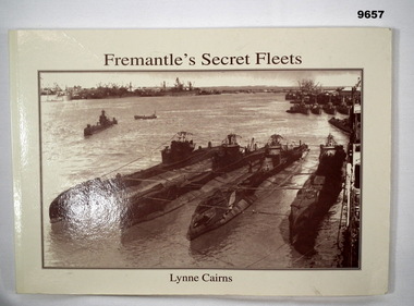
Book - MARITIME HISTORY, WW2, Lynne Cairns, 'FREMANTLE'S SECRET FLEETS", 1995
From the Title page - "Fremantle's Secret Fleets/ Allied submarines based in Western Australia during World War 2".Soft cover book. Cover - cardboard. Dark brown colour print front and back. Illustrated - front. Sepia colour photograph of Allied submarines in harbour - Fremantle, WA. 87 pages - cut, plain, cream colour paper. Print colour dark brown. Illustrated - sepia colour photographs and maps.publication, book, ww2, maritime history, fremantle -
 Ringwood and District Historical Society
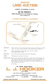
Flyer, Residential Land Auction - Heatherdale Road, Ringwood - 1973
Single-page advertisement for auction on Saturday 15th September (1973) - 9 residential allotments on Heatherdale Road, Ringwood. Includes summary of local services and facilities, and map of area showing Verdale State School, Manhattan Hotel-Motel, and directional arrow 3/4 mile to railway station (Heatherdale) to the north.Agent - L.J. Hooker Vic. Limited, Hooker House, 327 Collins Street, Melbourne 3000, Telephone 62 0181, A.H. 232 3481, Telegrams HOOKCO. -
 Ringwood and District Historical Society
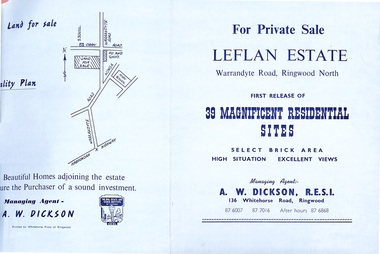
Document - Folder, Land Sale - Leflan Estate, North Ringwood, Vic. - circa 1967
Bi-fold land sale advertisements for stages 1 and 3 releases of residential allotments in Leflan Estate, Ringwood North, circa 1965-1967. Brochures include area map, layout of the estate, and summary of local facilities and services, with separate attachment listing lot number prices for 2nd and 3rd releases.Subdivision includes Melview Drive, Leslie Grove, Leflan Close, Warrandyte Road and Lockhart Street. Agent - A.W. Dickson, R.E.S.I., 136 Whitehorse Road, Ringwood. (Phone) 870-6007, 870-7016, After hours 870-6868. -
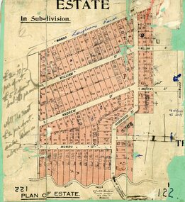
 Ringwood and District Historical Society
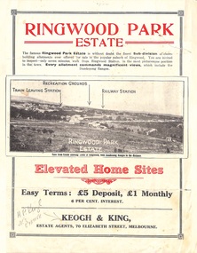
Flyer, Sub-divisional residential land sale advertisement - Ringwood Park Estate, Ringwood, Vic. - circa 1922
Folded double-sided page with black and white photographs of local views with black and red print advertising elevated home sites, including terms of sale, locality map, and description of local facilities and services, with blocks marked as SOLD subsequent to auction sale December 1922. (See Record ID no.5249)Subdivision includes Wonga Road (later Loughnan Road), William Street, Andrew Street, Munro Street and Harrison Street. Estate Agents - Keogh & King, 70 Elizabeth Street, Melbourne, Telephone 6938. -
Port Melbourne Historical & Preservation Society
Badge (Item) - To the Women of Australia badge, Commonwealth Government
To the Women of Australia and on reverse side Issued by C'wealth Govt war - world war ii -
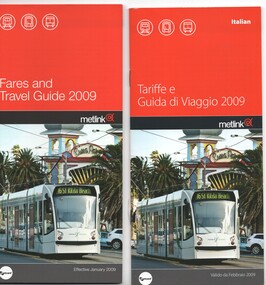 Melbourne Tram Museum
Pamphlet, Metlink, "Fares and Travel Guide", 2009
Set of four "Fares and Travel Guide" for 2009. Has contact details, and maps of the tram and train systems of Melbourne. Details fares, Metcard products, buying and validating Metcards, concession cards, refunds, travelling with pets, surfboards, general info. .1 - English .2 - Italian .3 - Chinese .4 - Arabictrams, tramways, tickets, fares, yarra trams, guides -
 Ringwood and District Historical Society
Map, Subdivision Plan, Loughnans Road, Ringwood - circa 1922
Green card with cut-out map of residential allotments, some marked "sold". "Plan of Estate" includes Wonga Road, Loughnans Road, William Street, Andrew Street, Harrison Street, and Munro Street, Ringwood. (Surrounding area is part of Ringwood Park Estate featured in seperate 1922 auction flyer).Handwritten notations - (northern section) {£2-10/- per foot. £5 deposit bal £1 per month} All the rest £2 per foot, value same as above. Licensed Surveyors - W.J. & A.W. Kenhardt, 352 Collins Street, Melbourne. -
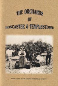 Surrey Hills Historical Society Collection
Book, The Orchards of Doncaster & Templestowe
For 100 years Doncaster-Templestowe was a major fruit producing area. The industry had a profound effect on the landscape and vegetation. Although orcharding families came from a variety of backgrounds, German families were an important sub-group.A comprehensive history of fruit growing in the Doncaster-Templestowe area between 1850s and 1950s when orchards began to be subdivided for housing. It includes B&W photos and line drawings and maps. It covers details of the varieties grown, the families involved, pests, machinery involved, markets, blacksmiths and reasons for the demise of the industry in the area.irvine green, eric collyer, doncaster-templestowe historical society, gottlieb thiele, ruffey creek, bismarck street, victoria street, thomas petty, george hislop, john whitten, john clay, august aumann, carl hanke, gottfried uebergang, waldau, max schramm, german lane, george street, john tully, henry crouch, george tortice, august zerbe, jane serpell, sidney williams, phylloxera, joseph bosisto, richard serpell, frederick thiele, w s williams, edwin lawford, james read, john finger, richard clay, ferdinand finger, leeds street, wetherby road, john russell, sarah uebergang, mary hislop, rudolph werner, john petty, archibald mclaren, john hicks, joe hicks, john smedley, william smedley, william hunter, sylvester mullens, laurie's forge, curtis hillman, anne hillman, dan harvey, calder's forge, hillman's blacksmith works, thomas serpell, gill smith, victorian fruit growers association, h g reynolds, alfred thiele, william webb, fred zerbe, mary anne clay, orchardist's coolstore, r h werner & co, j h land, orchardists and fruit cool stores association, a t petty, r read, r chivers, jack noonan, arthur ireland, jack robinson, george knee, donvale cool store, herb petty, frank petty, fred tolly, gordon white, blue moon fruit co-operative ltd, kathleen petty, peg chivers, jack russell, mathew adams, george mcgahy, edwin bullock, james hodson, edwin wilson, david corbett, edwin lowford, thomas beavis, william hanke, tom petty, edward crossman, andrew zander, carl aumann, heinrich fromhold, thomas chivers, william williams, reinhold denhert, henry finger, august furhmann, henry serpell, john ireland, frank smedley, william kent, william knee, thomas buck, henry white, gottlieb leber, alexander speers -
 Bendigo Historical Society Inc.
Map - STRUGNELL COLLECTION: HUSTLER'S Royal Reserve Shaft No. 2 Bendigo, September 1913
Map, Hustler's Line of Reef, Hustler's Royal Reserves No. 2 Co, Longitudinal Section.Plate No.V111 (8). Bulletin No 33 Signed H.A.Whitelaw Underground survey Office Bendigo September 1913 Drawing shows mine shaft to over 1746 feet deep and appears to show samples of connecting horizontal shaftsUnderground Survey Office, Bendigo.map, bendigo, hustler's royal reserve no. 2 mine* -
 Bendigo Military Museum
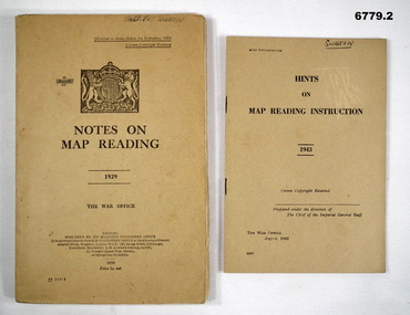
Manual - MAP READING, British War Office, 1929 - 1943
Items in the collection re Col J. Swatton, refer Cat No 6719.2P for his service details. 1. This is an Army Training Manual. on the front is the British Coat of Arms. The book's title dated 1929. Khaki cardboard cover. Printed in black ink. It has 93 pages of text, maps and drawings. 2. Small booklet, Khaki cover, Prtinted in black ink dated 1943. British War Office.1. On front cover is "Illegible" and W. Swatton. Inside front cover is handmade amendment chart. Daily entry is dated April 1938. On rear cover is a sticky label with the words "On loan from the Estate of Colonel J, W. Swatton" Ref No JWS M18. 2. On front cover is written name "Swatton". On rear cover is a sticky label with words..."On loan from the Estate of Colonel J. W. Swatton." Ref No JWS M19.map reading, j. w. swatton, passchendaele barracks trust -
 Bendigo Military Museum
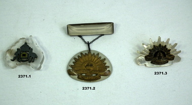
Memorabilia - TRENCH ART, BROOCHES VARIOUS, C.1939 - 45
Items in the collection re J.C.W. LEDEUX, refer Cat No 2378 for his service details. These items are classed as Trench Art WW2..1) Perspex map of Australia with Australian coat of arms in metal in centre. Has shape of colour patch in centre. Australian Armoured Division. .2) Perspex bar with Rising Sun badge suspended beneath on chain. .3) Mother of pearl Rising Sun with metal Rising Sun badge in brass in centre. costume accessories - jewellery, military history - souvenirs, numismatics, trench art -
 Mission to Seafarers Victoria
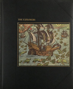
Book, Time-Life Books, The Explorers, 1978
... maps ...Illustrations of the time of explorationBlack cover with picture of ship and embossed gilded writingsnon-fictionIllustrations of the time of explorationseafarers, time life books, explorers, maps, india, christopher columbus, marco polo, caravel, navigation, the americas, spain, portugal -
 Greensborough Historical Society
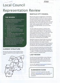
Document - Document Collection, Local Council Representation Review, 2019_
Contents: 2 x Newspaper Clippings: Banyule City Council Electoral Representative Review, Heidelberg Leader 20/08/2019 and Diamond Valley Leader 21/08/2019. Local Council Representative Review Submission Guide. Victorian Electoral Commission, 2019. 24 p., text. General information for those making a submission to a review. Local Council Representative Review Preliminary Report: Banyule City Council. Victorian Electoral Commission, August 2019. 31 p., text and colour maps. Reports on submissions and gives 3 options for electoral review in Banyule. Local Council Representative Review: Banyule City Council 1. Public hearing agenda and attachments. 25/09/2019. 9 p. 2. Public hearing agenda and attachments. 25/09/2019. 2 p. Agenda and handwritten notes by R. Bray. Local Council Representative Review Final Report: Banyule City Council. Victorian Electoral Commission, October 2019. 46 p., text and colour map. Recommends increasing the number of councillors and wards to 9. 2 newspaper clippings, 3 booklets and agenda with attachments. Filed in black plastic folder.banyule city council, victorian electoral commission, local council representative review 2019 -
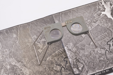 Forests Commission Retired Personnel Association (FCRPA)
Pocket Stereoscope
This pocket stereoscope was used to view a pair of separate and overlapping aerial photos as a single three-dimensional image. It was small and could be easily used in the field. Larger, mirror stereoscope were also available in some offices. The aerial images were used to map forest types, timber stands, new roads and tracks, firebreaks, boundaries of timber harvesting, plantations, bushfires, insect and disease attack and so on In 1928, the Forests Commission undertook its first major aerial photography project over 15,000 acres of forest which is said to be the first of its kind in Australia. During the Second World War, large areas of Victoria were photographed by RAAF and used to produce orthophoto maps. By 1945 aerial photography of 13,000 square miles (3.4 M ha) was completed, including much of the inaccessible eastern forests. The Forests Commission started developing its own small format photography in the early 1970s. Simple, cheap and rapid methods of obtaining photographs using 70mm and 35mm cameras were developed Small pocket stereoscope to interprete aerial photographs in the field Adjustable lenses on foldaway wire legsSokkisha Tokyoforest measurement, surveying, forests commission victoria (fcv) -
Bendigo Historical Society Inc.
Map - SECTIONS ACROSS BENDIGO GOLDFIELD
Map in three sections showing sections across Bendigo Gold Field, showing anticlines, synclines, faults, stratigraphical zones and mines along the reef lines. Key shows rock types Castlemaine, Bendigo B1, B2, B3 and B4, and Lancefieldian. First part of map shows sections A-A, B-B and C-C. Reef lines drawn with mines listed: Fault line shown are the Carshalton, Stafford, New Chum, Virginia and Clarence. A datum line shows 600 ft above sea level. On bottom of plan: ' Prepared in the Geological Survey Office, Bendigo, under the direction of H. Herman, late Director of Geological Survey, from surveys by H.S. Whitelaw, Field Geologist, assisted by E.S. Usher, A.J.J. Moore and R.A. Keble.' Second section of map shows sections D-D, and E-E. Fault lines listed are the Tambour Major fault, Carshalton fault, Stafford fault, Nell Gwynne fault, New Chum fault, Deborah fault. Third section shows sections F-F and G-G. Fault lines listed are the Bird Reef fault, Kangaroo Gully fault, Langdon fault, Carshalton fault, Nell Gwynne fault, Spring Gully fault, Hustlers fault, Gravel Hill fault, Ordes fault, Thanet fault. This map forms part of the Geological Survey of Victoria, Structure of Bendigo Goldfield report, No. 47, 1923. H.Herman, late Director of Geological Survey.Geological Survey of Victoriabendigo, gold mining, reef line maps -
 Melton City Libraries
Map, Streets of Melton, 1963
MELTON’S STREETS Heritage Week 2014 What’s in a Name? Alphabetical List Aboriginal place names, Early Family Names and landowners, Agricultural, Shop and Commercial premises, Places and Events Melton & District Historical Society Street Naming Project 1972 – c 1998 Suburb Name – KURUNJANG - Kirkton, 1972, Brookfield, West, 1988 Melton and Town Centre - A joint collaboration with the Shire of Melton and Subdivision Developers ARNOLD Court – Family house - Arnolds Creek ALKEMADE Drive Family – Lime kilns Coimadia ALEXANDRA Street 1902 – Corination of King Edward VII and Queen Alexandra AVIATOR Place Event, location of plane crash – Jimmy Melrose 1936 Adina ?Annibee - Anniba? Agricultural Avon court .. .. BAKERY Square - Location of Jongebloed shop, bakehouse and stables BALUK Place Aboriginal BARLEYCORN Place Agricultural BILLING Place Name of Jimmy Melrose Uncle Noel Pemberton Billing BLACKWOOD Drive - Alexander Blackwood 1860c Registrar BARRIES Road C. E. Barrie “Darlingsford” farmer 1911, chaff mill owner BROOKLYN Road Staughton family residence. 1875 – Dismantled c 193? CAHILL Drive Family - Glenville Dairy CAMERON Court Family Canopus Place ? CANALLAN Drive Early Surveyor CAMPBELL Court Aviation – Melrose passenger 6th July 1936 CARBERRY Drive Michael, early landowner family CAREW Court Edward and Michael. Royal Hotel. Vera (Carew) Forran Singer - Opera CASEY Court Family CASHIN Court Family CHEVIOT Court Agriculture, breed of sheep CHESNEY Road was re named ( Minns Road being duplicated c 1973) CHRISTINA Crescent Christina McPherson, daughter of James and Mary Mary McPherson. Died 1955 aged 85 years COLLYER Close a deleted street (parallel to Yuille) re-used CORRIEDALE Road Breed of sheep CORR Court Teacher at first school, landowner CROXTON Court Name of the Hornbuckle and Knox family home DALEY Court - William Daley and family 1865 Bootmaker High Street DARLINGSFORD Boulevard - Name of early homestead Thomas B Darling 1853 DJERRIWARRH Court - Parish County of Bourke - very early map. DODEMAIDE Place Early land owners - Melton Football Team had 6 brothers playing c 1924 DONALD Court McPherson family 6 generations in Melton in 1936 DOUGAL Court DUNCAN Court .. .. DUNVEGAN Circuit Home of the McPherson family, castle Isle of Skye Name of bluestone house Smith Street (now at Willows) EMIL Court Jongebloed family EXELL Avenue Farming family Melton Sth- Closer Settlement 1907 EXFORD Road Exe former name of the Werribee river FARMER Court Name of early postmistress FERRIS Road John Ferris Farmer HANNAH Close First name of Hannah Watts – midwife HAYBALE Place Agricultural HELDER Court Early surveyor J Helder Wedge map HEWSON Street Winston Hewson Shire Engineer – check title c 1960 HENRY Street Township map c 1860 HESTON Street Heston Phoenix – C.J. Melrose plane HILDEGARDE Court Jimmy Melrose’s mothers name HOMESTEAD Close HORNBUCKLE Cres Farmers. Three members of family - Shire Presidents HURLEY Street Farmers IAIN Court Descendent of James and Mary McPherson JAMES MELROSE Drive Name appears on 2013 Melton information map JANG Place KURUN – jang KIRKTON Drive Name of the McPherson family home Toolern Vale Road KIRWIN Street Michael early landowners (deleted for freeway construction) KILPATRICKS Road Deleted when Barries Road was extended across Station Rd KOROROIT Court Early map, Parish of Kororoit. Creek name KNOX Circuit Family – Hornbuckle “Croxton Park” KURRUNJANG Drive Aboriginal name for people of the red earth – Suburb name Lara Place ? LLOYD Court Garage owners High Street. Laura lived to 100 years D 1955 LUBY Court John Luby – Crown Grant Land Title LITTLE Court MANNING Avenue Richard, hotel owner 1891 MARGARET Drive McPherson family McDONALD Street Melton South family name McKENZIE Street Township c1860 MORROW Street Early name MOWBRAY Crescent Name of English Melton, popularly believed origin of Melton MYERS Court Early setters c 1866 Crown Grant Land Title NIMMO Street Early name NIXON Street Name submitted by Mary nee Nixon Collins c1985 OLDERSHAW Road Early builder PALMERSTON Street Early township map c 1860 PEART Court Early name PENNYROYAL Avenue Plant growing by the creek. Early name used for the Toolern Toolam Creek PINKERTON Street Family name and early street map PINNACLE Crescent Agricultural - type of wheat PHOENIX Circuit C.J. Melrose Phoenix Heston Plane 2013 map PRATT Family PRIOR Court PYKE Place Brothers – early settlement 1838 RADFORD Court Land owners and business operators. Former Royal Hotel Grocer High Street demolished 1970 RAGLAN Court Hotel 19th century Lord Raglan RALEIGHS Road Oliver Reierson family (Norweigen) Shopkeeper – Dressmakers RIDDELL Drive (misspelt Riddle) Resident and land owner RODERICK Road McPherson family – a re occurring name ROLLAND Court Jones family ROSS Court Daniel. Landowner. Agnes Ross music teacher RUSSELL Court Robert. Early land surveyor of Melton 1853 RYAN Court Family early landowner. Member of the 1862 Road Board SHEBLER Place Augustus early Melton resident – Golden Fleece Hotel SHEEPFOLD Court Farming SHERWIN Court Sherwin Street earliest Township map– became Golf course SMITH Street Early township map. STRATHULLOH Circuit Strathtulloh Homestead. STAUGHTON Street Family – LARGE land owners Strachan ? SWANEY Court Marie Swaney earlier resident of Strathtulloh. SUTHERLAND Family name TOOLERN Street TOOLAM – TOOLERN Creek TULLIDGE St Road marked on 1861 map UNITT Street Early Township c 1860 WALLACE Square Cr Jack Wallace 5 terms as President 46 years unopposed WATTS Court Hannah Watts – midwife, cottage hospital WALSINGHAM Name of house of Minns family. From Walsingham Norfolk England WESTLEY Place Name of Jimmy Melrose Percival Gull Plane WESTLAKE Drive Early resident WHICKHAM Street Family Name Melton South WILSON Road Albert, Melton South YUILLE Street William Cross, early landowner, Rockbank run Zoomed in section of Melton Streets including Church and High Streetlandscapes of significance -
 Glen Eira Historical Society
Photograph - Hawthorn Road, 342, Caulfield
Two items about this address: 1/Two colour photos of a commercial building under construction on Hawthorn Road in September 1987. Building is south of Glenhuntly Road on western side And was being built for Caulfield City Council. 2/Print of comment entered 03/03/2019 on Victorian Collections website for this file from reader Angus giving street number as '342'. Google map photo print done 04/04/2019 confirms this.hawthorn road, caulfield, caulfield city council, commercial buildings, council buildings -
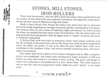 Eltham District Historical Society Inc
Folder, Eltham Flour Mill
Photocopied pages probably from "Flour mills and millers of the Goulburn Valley, 1858-1980" by Myrtle L. Ford (1981) relating to Eltham Flour Mill Proprietor William Ford and his predecessor Henry Dendy and the operation of the Eltham Flour Mill. Also includes pages from an unknown source describing the operation of the mill and map with location of mill marked. The Eltham Flour Mill was situated on the Diamond Creek below the location of the Eltham Community and Reception Centre.8 PagesHG Folders 113harry gilham collection, eltham flour mill, henry dendy, william ford -
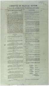 Unions Ballarat
Printed report of the Committee appointed by the Congress to draft a scheme for political reform - the National Political Reform League, 1891
Political reform was high on the agenda of Australian Congress Committees. The report includes the preamble, rules and platform. Ballarat was chosen as the venue for the important 7th Intercolonial Trade Union Congress of Australia in April 1891 at which certain resolutions concerning political action by the workers were passed. The 7th Intercolonial Trades Union Congress in Ballarat is considered to be the beginnings of the Victorian Labor Party and mapped out 'One Big Union' which ultimately led to the formation of the ACTU.Relates to the history of the BTLC, political reform and other Australian Congress Committees - see 0019-26.Paperballarat trades hall, ballarat trades and labour council, political reform, australian congress committees, btlc, national political reform league, 7th intercolonial trades union congress, labor party - victoria, alp, one big union, actu -
 The Beechworth Burke Museum Research Collection
Card (Series) - Index Card, George Tibbits, William Street, Beechworth, 1976
George Tibbits, University of Melbourne. Faculty of Architecture, Building and Town & Regional PlanningIndex system that support the research for Beechworth : historical reconstruction / [by] George Tibbits ... [et al]Arranged by street names of BeechworthEach index card includes: street name and number of property, image of property, allotment and section number, property owners and dates of ownership, description of the property according to rate records, property floor plan with dimensions.beechworth, george tibbitsbeechworth, george tibbits -
 Melbourne Tram Museum
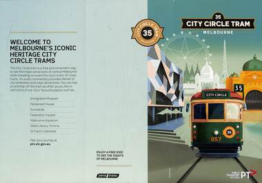
Pamphlet, Public Transport Victoria (PTV), "City Circle Tram", 2022
City Circle pamphlet - contains a map of the route and intersecting tram routes, with the route number "35" on both sides and major locations of interest. Has an image of W6 957 with a montage behind of inner Melbourne iconic buildings and the Docklands wheel. Gives times for the service with a QR code to check if the service is running that day Has Yarra Trams and PTV logos. In use during 2022/2023. On the day of cataloguing, Sunday, the service was shown as not running that day. Yields information about the City Circle tram service.Pamphlet - 3 fold DL - full colour. Two copies held.tramways, city circle, yarra trams, docklands, route 35, ptv -
 Marysville & District Historical Society
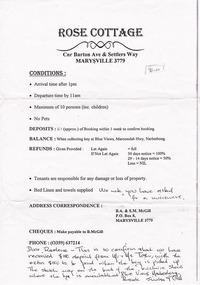
Ephemera (item) - List, ROSE COTTAGE, Unknown
A photocopy of a list of conditions and deposits paid for accommodation at Rose Cottage in Marysville. A photocopy of a list of conditions and deposits paid for accommodation at Rose Cottage in Marysville. We note you have asked/ for a microwave Dear Raelene - this is to confirm that we have/ received $180 deposit from Mr + Mrs T???, with the/ extra $180 to be paid when the key is picked up./ The sketch map on the back of the brochure shows/ where the key is available at Blue Views, Narbethong -/ Regards Shirley McGillmarysville, victoria, australia, rose cottage, accommodation, list of conditions, b.a. & s.m. mcgill -
 Orbost & District Historical Society
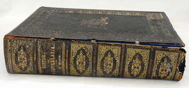
book, History of Australasia, 1879
"The History of Australasia" by David Blair was one of three important publications of the author. Written in 1879, the book relates the history of both Australia and New Zealand from their discovery through to the establishment of self-government in both colonies. Blair was born in Ireland and after studying for the ministry in Ireland came to Australia in 1850. Instead of a missionary career he took up journalism, became a member of the Legislative Assembly in Victoria and published his books on Australasia.A large thick hard leather covered book -History of Australasia by David Blair and published in 1879. The covers are black with a gold pattern border. The front cover shows an embossed Australian crest in gilt with kangaroo and emu and ' Advance Australia'. It is an illustrated edition with beautifully coloured maps for each Australian colony and New Zealand.book blair-david history-australasia -
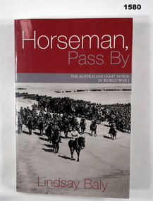 Bendigo Military Museum
Book - BOOK, WW1, Lindsay Baly, "Horseman, Pass By", 2003
"Horseman, Pass By. The Australian Light Horse in World War 1".Soft cover book. Cover - cardboard, white, red and grey colour print on front, spine and back. Front and back covers illustrated black and white photograph, a mounted division (of soldiers on horseback) march out. 337 pages, cut, plain white paper. Illustrated in black and white photographs, maps and diagrams.books, ww1, light horse