Showing 123798 items matching "main-road"
-
 Glen Eira Historical Society
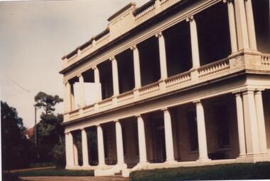
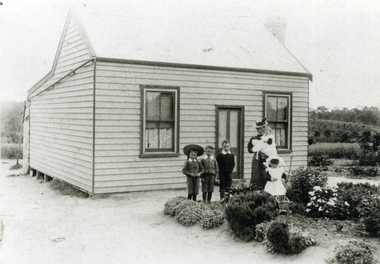
Photograph - Kilwinning, Balaclava Road
A colour photograph (101mm x 149mm) of the exterior of the house Kilwinning at Balaclava Road circa 1960. The file also includes two colour photocopies of a photograph (190mm x 239mm) of the exterior of Kilwinning showing the driveway and the garden in full bloom. A handwritten note on one of the copies provides that the house was demolished in 1965.kilwinning, balaclava road, davies j, house names, houses, architectural features, gardens, caulfield, st kilda east -
 Whitehorse Historical Society Inc.
Photograph, The Railway Crossing from Station Street, 1/06/2009
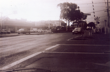
One of a collection of photographs taken of the Nunawading Railway Station prior to the lowering of the railway line and building of the new railway station on the western side of Springvale Road so that the Springvale Road Rail Crossing can be eliminated.Black & white photograph of he precinct surrounding the Nunawading Station and the Springvale Road Railway crossing. This photograph is of the crossing from Station Street. The liquor on the corner of Springvale Road and Oval way is in the background. See NP 3545 to NP3567 for the complete set of photographsnunawading railway station, springvale road nunawading, redevelopment of railway line/springvale road., oval way nunawading -
 Whitehorse Historical Society Inc.
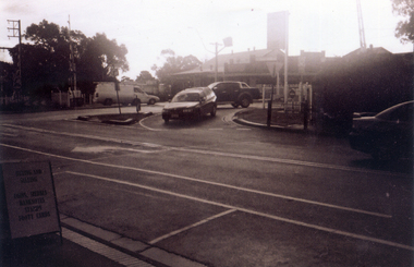
Photograph, Service Station -Now Works Site Office, 1/06/2009
One of a collection of photographs taken of the Nunawading Railway Station prior to the lowering of the railway line and building of the new railway station on the western side of Springvale Road so that the Springvale Road Rail Crossing can be eliminated.Black & white photograph of he precinct surrounding the Nunawading Station and the Springvale Road Railway crossing. This photograph is former Service Station on west side of Springvale Road. Now works site office. See NP 3545 to NP3567 for the complete set of photographsnunawading railway station, springvale road nunawading, redevelopment of railway line/springvale road. -
 Whitehorse Historical Society Inc.
Photograph, General View of Nunawading Station, 1/06/2009
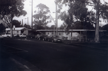
One of a collection of photographs taken of the Nunawading Railway Station prior to the lowering of the railway line and building of the new railway station on the western side of Springvale Road so that the Springvale Road Rail Crossing can be eliminated.Black & white photograph of he precinct surrounding the Nunawading Station and the Springvale Road Railway crossing. This photograph is view of the Nunawading Railway Station from Walker Road, showing the North an South Platforms. See NP 3545 to NP3567 for the complete set of photographsnunawading railway station, springvale road nunawading, redevelopment of railway line/springvale road., walkers road nunawading -
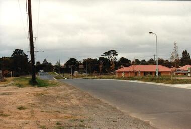 Hume City Civic Collection
Photograph, early 1990s
The series of 5 photographs feature different views of the Woodlands Housing Development which opened up land bounded by Gap and Anderson Roads, Cornish Street and Elizabeth Drive in the early 1990s. It was a large housing development built close to Sunbury township.A coloured photograph of one of the last housing developments which took place in the old township area. It is a photograph taken at the north end of Anderson Road looking towards Gap Road. One house has been built and there are a number of 'For Sale' signs of blocks fronting Anderson Road. Guttering and driveways have been formed on one side of the road.housing developments, anderson road, george evans collection -
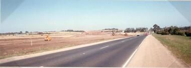 Hume City Civic Collection
Photograph
This photograph is of the duplication of the Calder Highway at Diggers Rest in the vicinity of Plumpton Road.A coloured panoramic view of the construction of the duplication of the Calder Highway in the vicinity of Plumpton Road. It is unmounted.calder highway, diggers rest, highway duplication, road construction and maintenance, plumpton road, george evans collection -
 Whitehorse Historical Society Inc.
Document, Certificate of Title - George Albert Smith, 1928, 1934
Certificate of TitleCertificate of Title for Lot 13 Railway Road, Mitcham and correspondence re outstanding rates.Certificate of Title shire of blackburn and mitcham, land titles, rates, smith, george albert, east road, mitcham, creek road, mitcham, railway road, mitcham, lot 13 -
Glenelg Shire Council Cultural Collection
Photograph - Photograph - Bridge Construction, 29/05/1957
Port of Portland Authority ArchivesFront: Back- 'Bridgewater road Bridge (otway street) 29/5/57' - pencilport of portland -
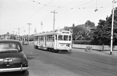 Melbourne Tram Museum
Negative - Tram 915 Centenary Car - Riversdale Road, Wal Jack, 11/02/1951
Photo by Wal Jack, of SW6 915, in Riversdale Road, Camberwell decorated for the 50th anniversary of Federal Government, 1951. Tram in bound to the City, Route 74 passing a stop 29 at Hasings Road. Note the shade in the overhead by the street light. Print dated 11-2-1951, though Wal Jack's album dates it as 9-2-1951. See also Reg Item 5179.Demonstrates a decorated tram.Black and white negative and copy print with photographers details on the rear."MMTB SW6 915 as Centenary Car from Burwood in Riversdale Road, Camberwell at Hastings Road stop no. 29, 11-Feb-1951 and Wal Jack Stamp with neg No. T693 written in,trams, tramways, sw6 class, riversdale road, tram stops, route 74, tram 915 -
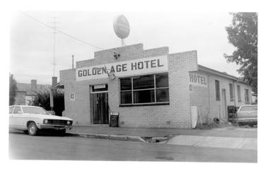 Tarnagulla History Archive
Photograph of the Golden Age Hotel, Tarnagulla, Late 1960s
Murray Comrie Collection. Building is still operating as the Golden Age Hotel on Commercial Road, Tarnagulla.Monochrome photograph depicting the Golden Age Hotel, located in Commercial Road, Tarnagulla.tarnagulla, commercial road, golden age hotel, buildings -
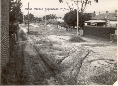 Chelsea & District Historical Society Inc
Photograph - First Avenue, Aspendale, 1949
This photo is one of a collection of photos taken during Alan Niemann's - Drainage-Road Making Scheme. First Avenue runs between Station Street and Sixth Avenue.Black and white photo looking east along First Avenue, Aspendale. The road us unmade and rusted with vegetation growing on the road, houses and electricity poles line both sides. unmade street, aspendale, first avenue, alan niemann, drainage-road making scheme -
Glen Eira Historical Society
Letter - Shoobra Road, 74, Elsternwick
Three documents about this property: Two photocopied typed (with handwritten working notes) documents from Brighton Historical Society on 74 Shoobra Road with similar brief history, includes tenants and owners from 1913 to 1974. Correspondence from Chris Haynes, owner of 74 Shoobra Road, to Peta McGregor, owner E Hrick 19 Shoobra Road, dated 24 March 2011 donated to Glen Eira Historical Society.shoobra road, elsternwick, hamilton thomas ferrier j.p. m.l.c, riddell john carre, devin leslie, rosstown railway property company, turpie david j., turpie emily mrs, green osmond d., woods charles, richards william, reeves alan r., davies j., taylor p.l., branson john, cheatley david, dyer s., bullock hilary miss, landells rosalind mrs, haynes chris, haynes ursula -
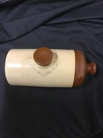 Mont De Lancey
Hot water bottle
stoneware hot water bottle, generally a cylindrical shape with an opening at the top and a round knob on one end which presumably functions as a holder. The main part of the body is cream, with the knob end brown.Stoneware hot water bottle with a screw in lid. Generally a cylindrical shape with an opening at the top and a round knob on one end which presumably functions as a holder. The main part of the body is cream, with the knob end and lid, brown.hot water bottles., bed warmers -
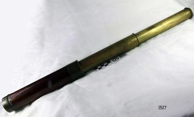 Flagstaff Hill Maritime Museum and Village
Telescope, 1780-1820
Not much is known about William Rothwell other than he is recorded as working as an optician and scientific instrument maker in Manchester at 277 Deansgate Street from 1780 until 1820. An entry in the “Complete History of the Trades of Manchester” published in 1822, in which the author describes Mr William Rothwell as an intelligent young man who is conversant in several languages. He went on to describe him as an philosophical instrument maker of optical and mathematical objects, specialising in spectacles, all sorts of surveyors instruments as well as eye glasses of all types. At present that is all that is known of William Rothwell other than his products were made to the highest standards of the time. Today his products are now actively sought by collectors and are currently fetching high prices at auction sales overseas. The telescope is a rare item even though not much is known about Rothwell's history his scientific instruments and optical items fetch high prices when they become available as collectors look for rare and well made items from the 18th and 19th centuries. Its completeness and good condition make it a very good addition to the collection at Flagstaff Hill. A three draw military telescope brass with main cylinder section made of wood, main lens is removable for cleaning.Marked "Rothwell, Manchester"flagstaff hill, warrnambool, shipwrecked-coast, flagstaff-hill, flagstaff-hill-maritime-museum, maritime-museum, shipwreck-coast, flagstaff-hill-maritime-village, telescope, william rothwell, scientific instrument, manchester optician, optician -
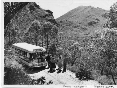 Halls Gap & Grampians Historical Society
Photograph - B/W, C 1960
The name of the road Henham Gap was later changed to MirranatwaPhoto shows bus and tourists on road looking over Henham Gap, Bus company - BoyVictorian Railways Photographaccess routes, roads, henham gap -
Whitehorse Historical Society Inc.
Document, Tunstall Town Estate, 1/03/1926 12:00:00 AM
Auction brochure of Tunstall Town Estate.Auction brochure of Tunstall Town Estate, cnr Whitehorse and Springvale Roads, Tunstall by Coghill & Haughton.Auction brochure of Tunstall Town Estate. kelly, john james, tunstall town estate, whitehorse road, tunstall, springfield road, tunstall, coghill & haughton, glendale street, nunawading, silver grove, nunawading, railway parade, nunawading -
![Construction of the electric tram line in Cotham Road [Kew]](/media/collectors/550653872162f11fb04854aa/items/662890b16214a76cee3ec4c2/item-media/662891076214a76cee3ed17d/item-fit-380x285.jpg) Kew Historical Society Inc
Kew Historical Society IncPhotograph - Construction of the electric tram line in Cotham Road [Kew], E.J. Dower, 1913
One of a small album of six photographs of the construction of the Cotham Road tramline in Kew, taken by Edgar James Dower in the second decade of the twentieth century. The reverse of each photo contains notes, written over time by the photographer, which are contained in the 'Inscriptions' field. Born and raised in Olinda, Dower's family later moved to Surrey Hills. He worked as an adult as a clerk in the city office of the Metropolitan Gas Company, and in his role as a 'collector', he was able to photograph scenes including the construction of tram and train lines and associated buildings in Kew, Hawthorn, Camberwell and Surrey Hills. Later he established a real estate agency with his brother - the E.J. Dower Real Estate Agency, Dandenong Office. The album as a whole can be viewed separately as the parent file.The image is an historically significant record of the development of transport infrastructure which was used to connect Victorians in the first two decades of the twentieth century. This development resulted from increases in population and the consequent extension of Melbourne's suburbs. The photographs in the album, as well as Dower's single photos mounted on card, individually and collectively richly detail the labour of workers and the tools and machinery used to create and extend Melbourne's tram and train networks in the years preceding and during World War 1.The fifth of six annotated photos in an album of photographs of the construction of the St Kilda to Kew electric tram line, taken in Cotham Road, Kew, by the amateur photographer, Edgar James Dower, in 1913. The album contains images detailing the preparation for the laying of the tracks plus work laying the line. The photographer notes on a number of the photos that the metal tracks were collected from the Hawthorn railway siding. The album, together with other phots by E.J. Dower has been made available by the owners for the Kew Historical Society to digitise and publish online and in print.Annotation verso: "Preparing tram line Cotham Road Kew for electric trams, looking west / 1913"keywords, theme -- connecting victorians by transport and communications, theme -- travelling by tram, photographers -- edgar james dower, cotham road -- kew (vic.) -
Glen Eira Historical Society
Drawing - St. Stephen’s Presbyterian Church, Caulfield
Two copies of a sixteen page booklet titled First Fifty Years, detailing a brief history, researched by John Watson, of St. Stephen’s Presbyterian Church, Balaclava Road Caulfield, between 1910-1960. The booklet includes several images, including two photographs, one of the interior of the church, the other of the interior of the main hall. There is also a set of six portrait photographs of the ministers of St. Stephen’s from 1913-1960. There is also a photograph of the front view of the first church and a sketch by Haddon and Henderson architects of the design for the present, 1960, church dated to the early-mid 1920s. There is a list of names of office-bearers for the year 1960. That list has been photocopied and is included in the file. Finally, there are two pages of handwritten notes, undated and unattributed, of information about St. Stephen’s derived from the First Fifty Years booklet.caulfield, st. stephen’s presbyterian church, presbyterian church, balaclava road, caulfield west, oulton street, watson john, kerry gordon f.g. rev., currie george, kinross george, haddon robert, thomson william rev., pollard mr., hunter c. hay m.a. rev., burns hugh m.m.a.b.d. rev., tamagno f. rev., simpson w.l. rev., goddard s.a.m.a.b.d. rev., robinson e.b. rev., adamson j. mr., jamieson r.f. mr., fraser w. mr., tannahill a.s. mr., mcilroy r. mr., smith f.b. mr., josephs a. mr., mac callum d. mr., darby g. mr., watson t.c. mr., attwood w.b. mr., wells organisation, land subdivisions, clergy residences, churches, settlements, community services, sunday schools, religious structures and establishments, architectural features, stained glass, paintings, farms, religious groups, ministers, monuments and memorials, clubs and associations, sporting clubs, p.w.m.u., presbyterian women’s missionary union, p.f.a., p.b.a., p.g.a., men’s brotherhood, soldier’s welfare association, youth executive, women’s league, dramatic club, halls, committees of management, building construction, fundraising events, business and finance, festivals and celebrations, religious ceremonies, architects, choirs, christian religion -
Glen Eira Historical Society
Document - Heatherbrae
A three page photocopy from a Caulfield Conservation Study by Andrew Ward, on house Heatherbrae located at 73 Neerim Road. The study gives a brief history of the property, describes the house’s architectural features and heritage significance and includes a photograph (100mm x 152mm) of the exterior of the house. The file also includes a page of undated, unattributed, handwritten notes giving a partial list of Heatherbrae’s occupants from 1885 to 1900s and some description of the house. Also included in the file is an undated, unattributed one page handwritten list of the main occupants of Heatherbrae between 1880 and 1970. The file also includes one page of research notes by Dianne Visnovsky, dated 06/11/2009, with details of a publication that describes church fairs held at Heathrbrae circa 1910. These notes are accompanied by a handwritten annotation by Claire Barton dated 05/03/2012.heatherbrae, mansions, neerim road, caulfield conservation study, architectural features, architectural styles, holland john charles, booran road, glenhuntly road, kambrook roads, griffiths george f, vail e l junior, clarke alfred e, clarke margaret h, mcgowan beatrice, mcgowan leslie, macgowan leslie, buildings, caulfield, heatherbrae avenue, clarke street, stoddart j, ross william murray, wright william t, macgowan m h, mcgowan malcom, mcgowan jean, barton claire, visnovsky dianne -
 Whitehorse Historical Society Inc.
Photograph, Eriksson Family Home, C.1903
Black and white photo of Family Group outside Eriksson Family Home, 17 Junction Road, Nunawading, Mrs Erikson nursing Olga (Mrs Steel) L-R: Harold, Cecil, Edgar and Mary (Mrs Skinner).eriksson, olga, harold, cecil, edgar, mary, steel, skinner -
 Glen Eira Historical Society
Photograph - Kooyong Road, 314, Caulfield South
Black and white photograph of house located at 314 Kooyong Road.kooyong road, caulfield south, architectural feature, houses, cast iron work -
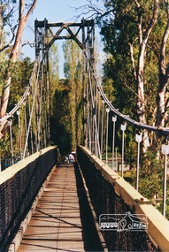 Eltham District Historical Society Inc
Photograph, Pedestrian suspension bridge over the Yarra River at Lower Plenty
Odyssey House drug rehabilitation centre in Bonds Road, Lower Plenty is a distinctive landmark, especially when viewed from across the Yarra at Templestowe. It was built in the 1950’s as a seminary for the Blessed Sacrament Fathers. Because of the poor and circuitous road access, a suspension footbridge was built across the river. As well as providing easy access for the priests residents of Templestowe could attend services at the seminary. The bridge is now part of the Yarra Trails system.Colour photograph of footbridge over Yarra River, part of the Ruffey Trail just off the Main Yarra Trail near the former seminary (now Odyssey House) Lower Plentybridges, yarra river, lower plenty, seminary, blessed sacrament fathers, odyssey house, bonds road -
Whitehorse Historical Society Inc.
Article, Winlaton Youth Training Centre, 2008?
History of Winlaton Youth Training Centre for female offenders.History of Winlaton Youth Training Centre for female offenders, which was located at 186 Springvale Road NunawadingHistory of Winlaton Youth Training Centre for female offenders.springvale road nunawading, no. 186, winlaton youth training centre -
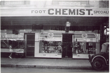 City of Moorabbin Historical Society (Operating the Box Cottage Museum)
Photograph, Black & White, Mr Moore's 1st Chemist Shop Centre Road, Bentleigh c1930, c1930
Early settlers in the Parish of Moorabbin, County of Bourke, established market gardens and farms in the area of Henry Dendy's Special Survey 1841 Brighton. Small communities grew near Churches & Schools and shops and businesses were established. Following the opening of the Railway line from Caulfield to Mordialloc 1881 the shops and business moved from the Tucker Road /Centre Road ( East Brighton ) East Bentleigh area to be close to the transport. Shops, businesses and housing developed along Centre Road between Thomas Street and Jasper Road. Mr Arthur Moore established his 1st shop in 395 Centre Road c1930 and later moved along the road to a site next to Coles Variety Store.Following the opening of the Railway line from Caulfield to Mordialloc 1881 the shops and business moved from the Tucker Road /Centre Road East Bentleigh area to be close to the transport. Shops, businesses and housing developed along Centre Road between Thomas Street and Jasper Road. Mr Moore established his 1st shop in 395 Centre Road c1930 and later moved along the road to a site next to Coles Variety Store.Black & White photograph of Mr Arthur Moore's 1st Chemist Shop, 384 Centre Road Bentleigh c 1930 back Handwritten information unsignedbentleigh shopping centre c1930, east brighton, railway line caulfield -mordialloc 1881, chemists, pharmacy, moore's moorabbin shire, smith j l, smith mary ann, stanley helen, smith vic, smith harry redvers, chaff cutter, horse drawn carts, toll gates brighton, motor cars 1900, steam engines, early settlers, bentleigh, mckinnon, parish of moorabbin, city of moorabbin, county of bourke, moorabbin roads board, shire of moorabbin, henry dendy's special survey 1841, were j.b., bent thomas, o'shannassy john, king richard, charman stephen, highett william, ormond francis, maynard dennis, market gardeners, vineyards, orchards -
 Vision Australia
Photograph - Image, Royal Victorian Institute for the Blind view from front lawn
View of RVIB building in St Kilda Road, taken from the front lawn. Leaves are scattered across the grass and a single male figure stands outside the building.1 black and white photograph of St Kilda Road buildingroyal victorian institute for the blind, buildings -
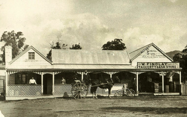 Marysville & District Historical Society
Photograph (Item) - Black and white photograph, Unknown
A black and white photograph of the Taggerty General Store in Victoria.A black and white photograph of the Taggerty General Store in Victoria.Original marked:- Mrs M. Gorman,/ 22 McKenzie St,/ Alexandra General Store at Taggerty. On road to Thornton, right side, on bend just pass Primary School TG6 POO448taggerty, victoria, taggerty general store, photograph -
Mission to Seafarers Victoria
Letter - Correspondence, 1949
Quinn Collection Three sheets of cream-coloured, lined paper (0800a1-3). Each sheet is written on one side only. Letter dated 1.01.1949 and headed Willoughby. The envelope (0800b) bears a lilac-coloured Australian stamp priced at one shilling and sixpence.0800.b is addressed to M.S.Fenris C/- Thor Ekerka Co. , 19 Rector Street, New York, post-marked 25-01-1949 and franked with the slogan 'Road carelessness kills'letters-from-abroad, quinn, 1949 -
 Melbourne Tram Museum
Slide - Black and white reproduction photograph - PMTT tram 4 Glenferrie Road 1910
Photograph - PMTT tram 4 Glenferrie Road 1910, possibly undertaking testing prior to the official opening on 30/5/1910. Photo shows the centre of the road overhead support poles in Glenferrie Road and a "Hail Cars Here" sign. In the background is the Malvern Town Hall, signs for Norwich Union and Walter Wright Hairdresser.Yields information about the opening of the tram lines built by the PMTTKodachrome cardboard duplicate slide - Black and white reproduction photograph - PMTT tram 4 Glenferrie Road 1910 "MP5" in penciltrams, tramways, opening, tram 4, pmtt, glenferrie road, tram stop -
Glen Eira Historical Society
Article - Hawthorn Road, 449, Caulfield South
One item on this address. An article and ads in PRW of 29/07/2011 about three new developments in Caulfield South. Included is a short history and description of the suburb. The projects are all on Hawthorn Road or Maple Street- Maple on the Park - a mixed use of developments Elle-luxury apartments Central Shule Chabad – new synagogue and community centrehawthorn road, caulfield south, land subdivision, shops, flats, caulfield primary school, towers, japanese school of melbourne, sporting clubs, mccubbin frederick, armadale bowls club, brighton cemetery, boyd arthur merricks, artists, bent sir thomas, premiers, bentleigh, bent street, jewish community, maple on the park, cbg architects, maple apartments, schacter max, property developers, century 21 wilson pride, real estate agents, elle, besser david, rosenwald yoel, amira gaby, harper terry, central shule chabad, synagogues, community centres, halls, beter-zionist youth movement, residential development, commercial development, eckstein joey, fein peter, liebowitz lionel, besser dion, butt rochelle -
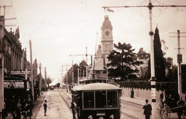
 Camberwell Historical Society
Postcard - Photo postcard, 1989
Glossy black and white photograph with white border on a postcard, depicting Burke Road dating around 1923. Photograph shows people crossing tram line surrounded by buildings, with horse and cart in the foreground.Back of postcard: Burke Road, Camberwell, c. 1923. La Trobe Collection, State Library of Victoria.