Showing 2592 items
matching parts of buildings or structures
-
 National Wool Museum
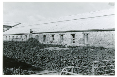
Photograph
Depicts Bungaree Shed, a big old store structure with the original part being commenced in 1842. The overgrown yard and old stonework can be seen clearly. Taken by John Bailey in South Australia at the request of Gael Shannon (former NWM employee). -
 National Wool Museum
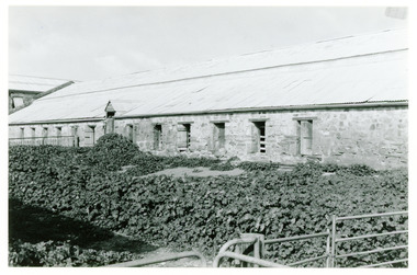
Photograph
Depicts Bungaree Shed, a big old store structure with the original part being commenced in 1842. The overgrown yard and old stonework can be seen clearly. Taken by John Bailey in South Australia at the request of Gael Shannon (former NWM employee). -
 Kew Historical Society Inc
Plan - Subdivision Plan, Six Big Home Sites, Camberwell North, c.1936
Subdivision plans are historically important documents used as evidence of the growth of suburbs in Australia. They frequently provide information about when the land was sold on which a built structure was subsequently constructed as well as evidence relating to surveyors and real estate and financial agents. The numerous subdivision plans in the Kew Historical Society's collection represent working documents, ranging from the initial sketches made in planning a subdivision to printed plans on which auctioneers or agents listed the prices for which individual lots were sold. In a number of cases, the reverse of a subdivision plan in the collection includes a photograph of a house that was also for sale by the agent. These photographs provide significant heritage information relating house design and decoration, fencing and household gardens.A subdivision in what is currently Balwyn, but which was advertised as being in Camberwell North. The subdivision included six allotments facing Buchanan Avenue and Houghton Street. The subdivision was to the east of the Pointed Firs Estate (1936). In addition to the intrinsic value of this subdivision plan, it also reveals information about the development of transport infrastructure in this area. The subdivision plan notes that the Tramways Board has approved the extension of the tram route past the current terminus at Balwyn Road.subdivision plans - camberwell -
 Kew Historical Society Inc
Plan - Subdivision Plan, Windella-Darnley Subdivision, Studley Park, 1920s
Subdivision plans are historically important documents used as evidence of the growth of suburbs in Australia. They frequently provide information about when the land was sold on which a built structure was subsequently constructed as well as evidence relating to surveyors and real estate and financial agents. The numerous subdivision plans in the Kew Historical Society's collection represent working documents, ranging from the initial sketches made in planning a subdivision to printed plans on which auctioneers or agents listed the prices for which individual lots were sold. In a number of cases, the reverse of a subdivision plan in the collection includes a photograph of a house that was also for sale by the agent. These photographs provide significant heritage information relating house design and decoration, fencing and household gardens.Version 1 of two subdivision plans (the later one is MAP.0027) for the section of Studley Park Road near the Junction on the south side. Named in the subdivision are the mansions of Darley and Windella (now demolished). Before the subdivision of Darley and Windella, both houses fronted Studley Park Road. Both houses appear to be advertised as lots in the subdivision. Bisecting the subdivision is a street, Antrim Avenue that was never constructed. A street, which was subsequently constructed in this vicinity, was Merrion Place, which now runs between Studley Park Road and Highfield Grove. There are 14 proposed lots in this subdivision."Antrim Avenue. See over for new plan"subdivision plans - kew, studley park, windella, darnley, studley park road -- kew (vic.), merrion place -- kew (vic.), merrion grove -- kew (vic.), highbury grove -- kew (vic.) -
 Kew Historical Society Inc
Plan - Subdivision Plan, Shop Sites, East Kew, c.1927
Subdivision plans are historically important documents used as evidence of the growth of suburbs in Australia. They frequently provide information about when the land was sold on which a built structure was subsequently constructed as well as evidence relating to surveyors and real estate and financial agents. The numerous subdivision plans in the Kew Historical Society's collection represent working documents, ranging from the initial sketches made in planning a subdivision to printed plans on which auctioneers or agents listed the prices for which individual lots were sold. In a number of cases, the reverse of a subdivision plan in the collection includes a photograph of a house that was also for sale by the agent. These photographs provide significant heritage information relating house design and decoration, fencing and household gardens.This is one of a small number of subdivision plans for commercial property in the collection. The subdivision proposed to create six shop sites in High Street between the Harp of Erin and Station Street. The plan shows this stretch of High Street, East Kew already lined with shops that include the hotel on the corner, the new State Savings Bank, a dentist’s surgery and Lambert’s Store. The High Street Tram was to reach Burke Road in 1925, so the proposed subdivision must postdate that event, and the opening of the Bank in 1926.subdivision plans - east kew, high street - east kew -
 Kew Historical Society Inc
Plan - Subdivision Plan, Eastlawn Estate, 1914
Subdivision plans are historically important documents used as evidence of the growth of suburbs in Australia. They frequently provide information about when the land was sold on which a built structure was subsequently constructed as well as evidence relating to surveyors and real estate and financial agents. The numerous subdivision plans in the Kew Historical Society's collection represent working documents, ranging from the initial sketches made in planning a subdivision to printed plans on which auctioneers or agents listed the prices for which individual lots were sold. In a number of cases, the reverse of a subdivision plan in the collection includes a photograph of a house that was also for sale by the agent. These photographs provide significant heritage information relating house design and decoration, fencing and household gardens.The ‘Eastlawn Estate’ was surveyed and ready for auction in March 1914, three months before the outbreak of World War I. Sixty-six allotments, created on the ‘order of Mr & Miss Preston’ surrounded the mansion of Woodlands in Harp Road. Woodlands formed part of the Estate, being advertised as lot 1. The allotments faced High, Station and Wright Streets, Harp and Normanby Roads, and Woodlands Avenue. Pru Sanderson in the Kew Conservation Study (Vol.2, 1988) wrote that the Eastlawn Estate ‘covered the western half of the failed Harp of Erin Estate’. Contemporary advertisements promoted the Eastlawn Estate as: ‘There will be no more convenient district nor pleasant Suburb than East Kew for the busy business man. When the Electric Tram is laid, he will be able to journey quickly and pleasantly direct from Collins Street to his home in the Eastlawn Estate in about 20 minutes’. The actual plans of subdivision were included in advertisements in The Argus and in the local newspapers.subdivision plans - east kew, eastlawn estate -
 Kew Historical Society Inc
Plan - Subdivision Plan, Raheen Estate Subdivision, 1960
Subdivision plans are historically important documents used as evidence of the growth of suburbs in Australia. They frequently provide information about when the land was sold on which a built structure was subsequently constructed as well as evidence relating to surveyors and real estate and financial agents. The numerous subdivision plans in the Kew Historical Society's collection represent working documents, ranging from the initial sketches made in planning a subdivision to printed plans on which auctioneers or agents listed the prices for which individual lots were sold. In a number of cases, the reverse of a subdivision plan in the collection includes a photograph of a house that was also for sale by the agent. These photographs provide significant heritage information relating house design and decoration, fencing and household gardens.The Raheen Estate Subdivision of 1960 involved the creation of 36 residential allotments and the sale of 34 of these. The land on which the subdivision was created had until 1960 formed part of the grounds of the mansion Raheen in Studley Park Road. In 1917, the Catholic Church had purchased Raheen and its lands. It was to become the home of Archbishop of Melbourne, Daniel Mannix, for 46 years. The sale of the subdivision took place three years before the Archbishop’s death. Subsequent archbishops were to reside at Raheen until its sale to the Pratt family in 1981. When the sale of the Estate was reported in the newspapers in 1960, it was described as the last big subdivision near Melbourne. At the auction, 33 of the 36 allotments were sold. The auction realised £315,750. Purchasers were advised that the vendor intended to keep lots 22 and 23. The alllotments in the subdivision required the construction of new roads. These included Eamon Court and Raheen Drive. The justification provided by the Church for the sale was that the estate was being sold to finance school building projects.subdivision plans - kew, studley park, raheen estate, eamon court, studley park road, coombes avenue, raheen drive -
 Port Melbourne Historical & Preservation Society
Photograph - Demoliton, New Great Britain Hotel, 197 Stokes Street, Port Melbourne, Lloyd Finch, Apr 2003
Owners of the former New Britain, Phil and ? COLLINS over 2003-2004 demolished portions and extended the structure. Added upper decks, swimming pool etc. Aptil demolition was recorded by neighbour Lloyd FINCH from roof of 201 Stokes Street.Photos taken during demolition of back New Britain Hotel, 197 Stokes Street. From roof of 201 Stokes Street by owners L&A FINCH, April 2003. .01 - .03 View of partially demolished back room, morning sun (vertical) .04 - More demolition .05 - Partially demolished dunny .06 - More demolition .07 - .08 South west corner cold storage, wide view .09 Envelope portionphil collins, lloyd finch, new great britain hotel, built environment - commercial, built environment - domestic, stokes street, built environment - demolition, business and traders - hotels -
 Melbourne Tram Museum
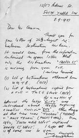
Letter - Malvern tram depot destination roll, Clive M Gibson, 1987
Letter from Clive Gibson to a Mr Caurran regarding the structure and history of some of the destinations on the roll including a change in the size of the letters, eg "CITY" a change made during 1943/44. Includes two lists dated 1958 for Malvern Depot.Yields information about the history of the Malvern Depot destination roll.One page letter with two photocopied A4 sheets dated 8-9-1987tramways, mmtb, destinations, malvern depot, destination rolls -
 Nillumbik Shire Council
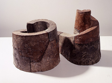
Sculpture: Mark STONER (b.1951 UK, arrived 1957 AUS), Untitled Spiral, 1991
A small scale concrete work that can be imagined as an ancient monolithic fortress or religious edifice. It suggests ideas like perpetuity, worship, preservation and history. Untitled Spiral is made up of three spirals, the first is constructed as a closed form, the second is open and the third is the space created within the second. The sense of enclosure is powerful but this is offset by the ledge which traces the top edge of the spiral shapes. This pathway leads from a precarious position to the highest point of sanctuary, or to what Stoner refers to as Nirvana. The structure is built of masonry-like units which "suggest a material presence and earthiness". Stoner is absorbed by how we define landscape and what is meant by natural. He is interested in the notion that ancient man-made structures such as stone walls, which are intrinsic to many landscapes, can now be accepted as being natural, organic forms. -
 Flagstaff Hill Maritime Museum and Village
Equipment - Rigging
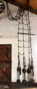
The shrouds or fore-rigging are a part of the standing rigging on a sailing ship. They are used in pairs on each side of a ship to help hold the masts in place and to aid the sailors who climb the rigging. They are part of the basic framework for the sails. Larger vessels may have two or three pairs, and some ships may have upper and lower shrouds. The upper shrouds would be fixed to a protruding structure on the top of the masts so that they hung from the right angle. The ropework skills of the sailmaker would be used to create the shrouds, choosing fibres with properties suitable for the job at hand and creating the triangular shape carefully. Deadeyes and ropes were then used to attach the shrouds to the ship's structure.This shroud is an example of a part of the standing rigging of a sailing ship. Shrouds were used in pairs on larger sailing vessels to help hold the masts in place and give access to adjustable rigging such as sails.Fore Rigging or Shrouds, made from rope fibres. This shroud includes the upper and lower wooden deadeyes. They are part of a ship's rigging. flagstaff hill, warrnambool, maritime museum, maritime village, great ocean road, shipwreck coast, shroud, fore-rigging, ropework, sailing ship rigging, standing rigging, natural fibres, sailmakers, handmade, deadeye, knot making -
 Flagstaff Hill Maritime Museum and Village
Equipment - Rigging
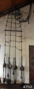
The shrouds or fore-rigging are a part of the standing rigging on a sailing ship. They are used in pairs on each side of a ship to help hold the masts in place and to aid the sailors who climb the rigging. They are part of the basic framework for the sails. Larger vessels may have two or three pairs, and some ships may have upper and lower shrouds. The upper shrouds would be fixed to a protruding structure on the top of the masts so that they hung from the right angle. The ropework skills of the sailmaker would be used to create the shrouds, choosing fibres with properties suitable for the job at hand and creating the triangular shape carefully. Deadeyes and ropes were then used to attach the shrouds to the ship's structure.This shroud is an example of a part of the standing rigging of a sailing ship. Shrouds were used in pairs on larger sailing vessels to help hold the masts in place and give access to adjustable rigging such as sails.Fore Rigging or Shrouds, made from rope fibres. This shroud includes the upper and lower wooden deadeyes. They are part of a ship's rigging.flagstaff hill, warrnambool, maritime museum, maritime village, great ocean road, shipwreck coast, shroud, fore-rigging, ropework, knot making, sailing ship rigging, standing rigging, natural fibres, sailmakers, handmade, deadeye -
 Marysville & District Historical Society
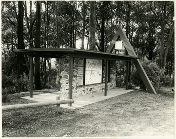
Photograph (Item) - Black and white photographs, Unknown
Two black and white photographs of the tourist information board which is at the entrance to Marysville. The Marysville Tourist and Progress Association were responsible for the building of this structure. It contains maps and information for attractions in and around the local area as well as information pertaining to local clubs and organisations.Two black and white photographs of the tourist information board which is at the entrance to Marysville. The Marysville Tourist and Progress Association were responsible for the building of this structure. It contains maps and information for attractions in and around the local area as well as information pertaining to local clubs and organisations.marysville, victoria, marysville tourist and progress association, tourism information, tourism -
 Kew Historical Society Inc
Plan - Subdivision Plan, Windella-Darnley Subdivision, Studley Park, 1920s
Subdivision plans are historically important documents used as evidence of the growth of suburbs in Australia. They frequently provide information about when the land was sold on which a built structure was subsequently constructed as well as evidence relating to surveyors and real estate and financial agents. The numerous subdivision plans in the Kew Historical Society's collection represent working documents, ranging from the initial sketches made in planning a subdivision to printed plans on which auctioneers or agents listed the prices for which individual lots were sold. In a number of cases, the reverse of a subdivision plan in the collection includes a photograph of a house that was also for sale by the agent. These photographs provide significant heritage information relating house design and decoration, fencing and household gardens.Version 2 of two subdivision plans (the earlier is 2016.0305.1) for the section of Studley Park Road near the Junction on the south side. Named in the subdivision are the mansions of Darley and Windella (now demolished). Before the subdivision of Darley and Windella, both houses fronted Studley Park Road. Both houses appear to be advertised as lots in the subdivision. Bisecting the subdivision is a street, Antrim Avenue that was never constructed. A street, which was subsequently constructed in this vicinity, was Merrion Place, which now runs between Studley Park Road and Highfield Grove. There are 13 proposed lots in this subdivision in contrast to the earlier plan. This resulted from larger lots being proposed for Studley Park Road.subdivision plans - kew, studley park, windella, darnley, antrim avenue -- kew (vic.), studley park road -- kew (vic.), merrion place -- kew (vic.), merrion grove -- kew (vic.), highbury grove -- kew (vic.) -
Glen Eira Historical Society
Document - Murrumbeena State School No. 3449
Submission to Caulfield Council for the construction of a Community Education Facility/Multi- Purpose Room for Murrumbeena State School Prepared for submission April, 1981, Rationale for costing of Community Education/ Multi- Purpose facility. Contains Street maps of area, Plans for proposed new structuremurrumbeena state school, hobart road murrumbeena, school, caulfield city council, school council, howard and munro architects., community education, facility, site plans, murrumbeena primary school council, education department. -
 Hume City Civic Collection
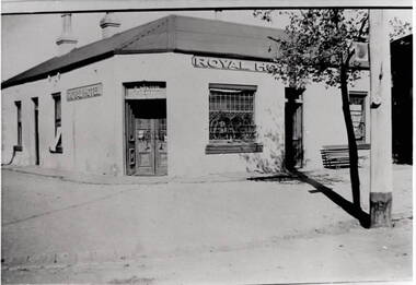
Photograph, Royal Hotel
This is an image of the original single storey Royal Hotel building which was on the corner of Brook and Evans Streets. In the 1930s the single storey structure was demolished after a fire and replaced with a double storey Art Deco red brick building, which still stands on the same site.At one stage there were four hotels in Evans Street between Station Street and Brook Street. At some stage the Millett family owned them. The Royal and the Olive Tree (formerly the Railway) hotels remain on their original site but not in their original appearance.A black and white photograph with a cream border of a single storey hotel building with a headlight window on the RHS of the corner entry doorway, which also has lead light windows. A young tree and power pole are seen on the RHS of the image. hotels, royal hotel, s.winter, t. millett -
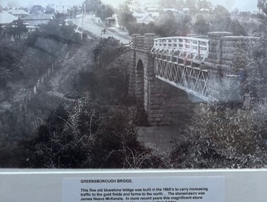 Greensborough Historical Society
Photograph - Photograph (Framed), Greensborough bridge, 1870s
Greensborough bridge caption reads: "This fine old bluestone bridge was built in the 1860s to carry increasing traffic to the gold fields and farms to the north. The stonemason was James Neave McKenzie. In more recent years this magnificent stone structure had to be replaced by a more modern bridge."From the John Davidson collection.Photograph in black plastic frame with typed caption on matte.john davidson, mckenzie bridge, greensborough, blue stone bridge -
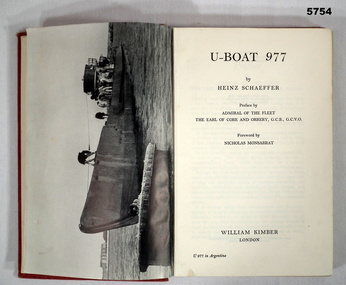 Bendigo Military Museum
Book - BOOK, GERMAN NAVY WW1, Heinz Schaeffer, "U Boat 977", 1952 First Edition
'U-Boat 977' Autobiography by Heinz SCHAEFFER, the last Commander of U-Boat 977.Hard cover book. Cover - cardboard, red colour buckram with gold print on the spine. 207 pages, cut, plain, off white paper. Illustrated black and white photographs. Front end papers - illustrated blue print "The Structure of a U - Boat". Back end papers - illustrated blue print - map "The Last Voyage of U977" Front end papers - handwritten prices.Front end papers - handwritten - grey lead pencil "18/9" and in blue ink "15c".books, military history, ww2, german navy, autobiography -
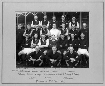 Victoria Police Museum
Photograph (Victoria Police), Police Officers group photo on sporting event, 1934
Black and white photograph mounted on grey frame. 24 men posing for photograph in 4row structure - on the background, arena style sitting area. On extreme left and right, 2 Police officers stand on their uniforms. On the middle and sitting, middle age man in suit. The other, are younger men (police officers?) in sporting outfits. [information of event on newspaper cutting stuck on the back - as described on Inscriptions]Handwritten in the front of the frame, bellow photograph: back row W.Parker. J.Power. B.Barker. A.Condie A. // P.V.Callahan (see)E.Brewis T.Robertson. E.White V.Burns R.Farrell S.Cannon // W.Brady J.Purdon R.Boyle E.Denham.Pres. W.Hudd. R.Priestley. J.Brody // W.Poulter F. F.Elliott J.Thompson // Premiers V.P.F.A. 1934 Stamp: H.M. WALKER // PHOTOGRAPHER // 117 COLLINS ST. // MELBOURNEvictoria police museum, police officers, police academy, police force, football, sports, vpfa, poulter, william arthur; h. m. walker parker; w. power; j. barker; b. condie; a. callahan; p. v. brewis; e. robertson; t. white; e. burns; v. farrell; r. cannon; s. brady; w. purdon; j. boyle; r. denham; e. hudd; w. priestley; r. brody; j. poulter; w. elliott; f. thompson; -
 Bendigo Historical Society Inc.
Newspaper - JENNY FOLEY COLLECTION: NEW CENTRE
Bendigo Advertiser ''The way we were'' from 2000. New centre: the Eaglehawk Town Hall just after its completion in 1901. Designed by Wilkinson and Permewan, who also designed the Castlemaine Town Hall, the building replaced a single-storey structure designed by Henry Tolhurst and finished in 1864. Before 1864, council meetings were held in Garby's Camp Hotel. The clip is in a folder.newspaper, bendigo advertiser, the way we were -
 Bendigo Historical Society Inc.
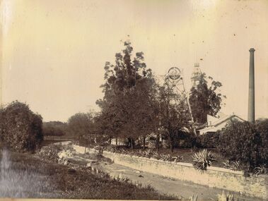
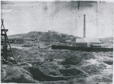
Photograph - HUSTLERS ROYAL RESERVE MINE, BENDIGO CREEK
Sepia image mounted on board: image shows Bendigo Creek, sandstone walls on creek. Creek is not yet paved with bluestone pitchers. On RH side Hustlers Royal Reserve Mine, chimney and poppet head visible. Poppet head has lattice girder legs. Post Office clock behind showing 25 to 4. Image is pre-1910, when mine structure was removed.bendigo, mining, hustlers royal reserve/bendigo creek, bendigo, sandhurst, bendigo creek, mining, huslters royal reserve, post office, poppet head, chimney -
 Bendigo Historical Society Inc.
Photograph - MINING LANDSCAPE, 1861
black and white photo: alluvial diggings in foreground, wheelbarrow, centre field stone building with galvanised iron roof with chimney at rear. 2 stascks of 6 foot timber for boiler. Headframe in front. Man standing under shelter near head frame. Midground, left tank of vertical plants. Hill with 5 whims to rear. A. frame and timber structure at centre left, mullock dumps.batchelderplace, landscape view, mining -
 Bendigo Historical Society Inc.
Document - BILL ASHMAN COLLECTION: CORRESPONDENCE
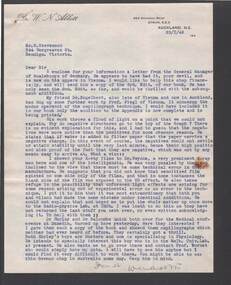
Letter, dated 23/1/48, to Mr. F. Stevenson. Written on paper with printed letterhead. Dr. W. N. Abbott printed in the left top corner. The writer mentions the General Manager of Scalebuoys in Germany. Also mentions negative structures and x-ray film and light effects. He also mentions that he had a visit from Dr Hurley and Dr. Belcombe Quick.sciences, instruments - general, scalebuoy, bill ashman collection - correspondence, dr w n abbott, mr f stevenson, dr engelbert, prof fiegl, dr gwynne, wilson, radio-physics lab, dr hurley, dr balcombe quick, melb univ lab, prof burnet -
Port Melbourne Historical & Preservation Society
Photograph - Foreshore views, Port Melbourne, 1925
Photos taken from the top of the Gingernut Bakery of Swallow and AriellCopies of three original photographs by William SWIFT (an employee at Swallow and Ariells) of Beach St, Port Melbourne in 1925 with Station Pier in the background. .01 shows "Weeroona" at Station Pier, with "Pennsylvania" and "Nevada" in the background .02 -shows new structure of Station Pier with "Seattle" and "Oklahoma" in background at Princes Pier .03 - shows breakwater between piers and COR in background. Visiting circus and fairgroundpiers and wharves - station pier, piers and wharves - princes pier, ps weeroona, uss seattle, uss oklahoma, cor, commonwealth oil refineries -
 Whitehorse Historical Society Inc.
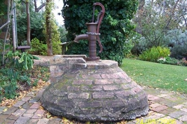
Functional object - Well and pump
The pump was restored by Alan Mitchell who was an employee of Zerbe Engineering, Ashburn Place, Blackburn. The work was carried out by Alan in their workshop.The pump was patented by Joseph W. Douglas, Middletown Conn. and the patent was assigned to W & B Douglas.A reconstructed well of red bricks. Circular, dome shaped, it has a grill on the flat top of the dome on which the force pump is situated next to the grill. It circulates the water which is held in a tank beneath the brick structure. The force pump is hand operated with a replacement handle made c1965 by Alan Mitchell who restored and donated the pump. The well is located outside the kitchen door of Schwerkolt Cottage.Patented 1842 M--D Conn.civil engineering, water supply, machinery, pumps -
 Ballarat Tramway Museum
Negative, Travis Jeffrey, 5/08/1962 12:00:00 AM
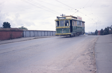
Colour Negative No. N406, of the Bendigo No. 7, showing Quarry Hill, crossing over the railway bridge, in Mitchell St with the railway bridge structure in the background. Tram has a Castrol Oil roof advertisement. Photo taken possibly on 5/8/1962. Colour laser printed copy of image stored in box 73. Original negative hires scan and image updated 28/5/2020.In red pen on folder that contained negative, "NR96B" and "5 Aug 62". trams, tramways, bendigo, railway station, mitchell st, tram 7 -
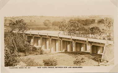 Kew Historical Society Inc
Postcard, Valentine Publishing Co Pty Ltd, New Yarra Bridge, Between Kew and Heidelberg, 1926-1930
Without bridges, Kew remained cut off from the City of Melbourne, only being accessible by Punt. Private and public bridges were constructed from the 1850s, beginning with the Hawthorn Bridge linking Bridge and Burwood Roads. A bridge across the Yarra at Burke Road was created as early as 1873. Since that first wooden bridge, a number of later bridges, typically on concrete pylons have been built, in 1926 and again during the 1970s.Angle view of the new Yarra bridge [ie. The Burke Road bridge] taken from the Kew side, showing the bridge’s structure. Trees line the river’s edge. In the distance can be seen a distant line of houses stretching to the horizon. The river appears to have an S-shaped bend beyond the bridge. The postcard, No. 227, was produced by the Valentine Publishing Co. Pty Ltd., of Queen Street, Melbourne.burke road bridge - kew (vic), bridges - kew (vic) -
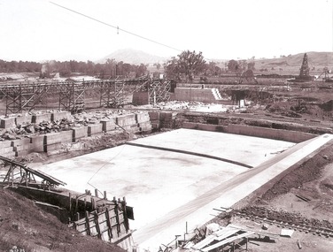 Wodonga & District Historical Society Inc
Album - Hume Reservoir Australia Album - Stilling pool opposite outlet section of dam, December 1925
This set of photos is from a leather bound album bearing the inscription "HUME RESERVOIR AUSTRALIA" plus 'The Rt. Hon. L. C. M. S. Amery, P. C., M .P.' all inscribed in gold. It was presented to The Rt. Hon. L. C. M. S. Amery, P. C., M. P, Secretary of State for Dominion Affairs on the occasion of his visit to the Hume Reservoir on 2nd November 1927. This album is of local and national significance as it documents the planning and development of the Hume Reservoir up to 1927. It was the largest water reservoir in the British Empire. The album records the pioneering engineering work that went into its construction.DEPARTMENT OF PUBLIC WORKS, N.S.W. RIVER MURRAY WATERS SCHEME. HUME RESERVOIR. 18. Stilling pool opposite outlet section of dam. New South Wales. December 1925 A stilling pool is a structure at the downstream side of a dam, designed to take away some of the energy from overtopping water flowing down the spillway, to reduce the risk of erosion of the ground near the dam and the dam itself.hume reservoir australia, river murray waters scheme, hume reservoir construction -
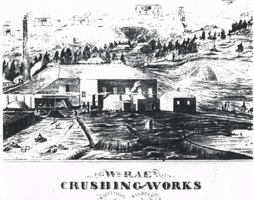 Bendigo Historical Society Inc.
Document - LONG GULLY HISTORY GROUP COLLECTION: WM RAE CRUSHING WORKS
William Rae (1823-1887) was born into a farming family in Scotland and came to Australia in i852. After coming to the Bendigo area, he established a puddling machine in American Gully. He then bought a claim on the Victoria reef and was quite successful. Subsequently he bought a steam engine and three batteries to begin crushing quartz. This was such a boon that he moved to a more convenient location in Happy Valley, where he set up a crushing battery with 35 heads.Sketch of a crushing works. Printed underneath is: Wm. Rae's Crushing Works, Happy Valley, Bendigo. Written on the back is: Happy Valley Rd. South side below Wells St. Picture shows a crushing works building with a tall chimney and some smaller outbuildings. On the hill in the background are poppet legs, other mine structures and some trees. There are heaps of mullock and in the foreground are a number of people.bendigo, history, long gully history group, the long gully history group - wm rae crushing works, george ellis -
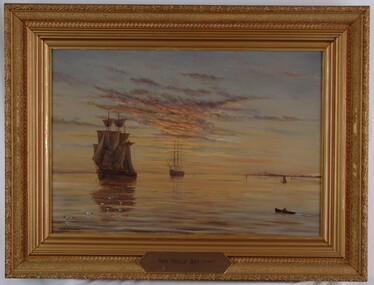 Glenelg Shire Council Cultural Collection
Painting, Port Phillip Bay (Sunset), n.d
UnknownScene of two sailing ships on a harbour at sunset. The ship on the left is in full sail, the ship on the right has furled sails. At front left is a flock of gulls and on front right is a figure in a row boat. At centre right is coastline with structures and several small boats. The sky has clouds reflecting the sunset in pink, yellow and indigo. These colours are reflected on the surface of the water. Framed in gilded wooden frame.Front: A.S. Murray (lower left) Port Phillip Bay (Sunset) (brass plate, l. centre of frame) Back: (no inscriptions) Conservation Centre, Melb. label.sea, seascape, maritime, sailing ships, sailing