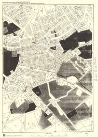
Showing 2091 items
matching bendigo maps
-
 Bendigo Historical Society Inc.
Map - LONG GULLY HISTORY GROUP COLLECTION: MAP - EAGLEHAWK ROAD
Map of part of Eaglehawk Road showing a Bike Ride Trail. Map is dated September 01, 1998, Scale 1:5000.bendigo, history, long gully history group, the long gully history group - map - eaglehawk road, natural resources and environment, bike ride trail -
 Bendigo Historical Society Inc.
Book - STRAUCH COLLECTION: RESEARCHING YOUR GERMAN ANCESTORS
Manilla folder containing information on researching your German ancestors with illustrations and a map.genealogy, family, german, genealogy-german -
 Bendigo Historical Society Inc.
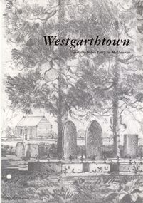
Book - STRAUCH COLLECTION: WESTGARTHTOWN
White 3 ring binder contains information on Westgarthtown,Tatura german heritage trail with illustrations, photographs and maps, mostly written in German language.victoria, history, german, history-victoria-german-westgarthtown-tatura -
 Bendigo Historical Society Inc.
Book - STRAUCH COLLECTION: WHROO CEMETERY VICTORIA
Red Spring binder containing list of interments in Whroo Cemetery with maps & illustrations.James & Nicola Thomsonplace, cemetery, whroo, victoria-whroo-rusthworth-history-cemetery -
 Bendigo Historical Society Inc.
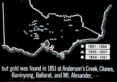
Slide - DIGGERS & MINING. THE GOLD ERA, c1851
Diggers & mining. But gold was found in 1851 at Anderson's Creek, Clunes, Buninyong, Ballarat, and Mt. Alexander, - - - Slide shows map of Victoria with legend to show when gold was found in different areas. The gold era. Markings 4 994.031 GOL:5. Used as a teaching aid. Used as a teaching aid.hanimounteducation, tertiary, goldfields -
 Bendigo Historical Society Inc.
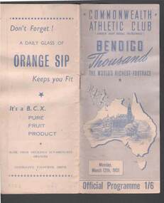
Document - BENDIGO THOUSAND PROGRAM 1951
Program for the Bendigo Thousand, dated Monday, March 12th, 1951. It has a pale blue cover with a map of Australia and some foot runners on the front. Inside the map is a sketch of Pall Mall showing the Post Office and Memorial Hall. Contents include the names of Officials, the contestants in the races, 130 Yards Time Chart, Honor for Champion, Bendigo's Gift Track, Bookmakers' Names and Stand Numbers, a Trotting Race, Scratchings and Red Cross Emergency. Photos include Lloyd La Beach - Competitor, Mr. J. J. Fewster - Secretary, and S. P. Baldwin Winning 1950 Thousand. Included are advertisements: Romney Tailored Knitcraft for Men and Boys, Hearn's Newsagency, Hanro, and B.C.X. Commonwealth Athletic club brochureevent, sports, athletics, bendigo thousand program 1951, commonwealth athletic club, lloyd la beach, albert matthews, barney ewell, j j fewster, hon l w galvin, a e matthews, a j wearne, a w hogben, c michelsen, g wearne, m spencer, the rt hon mr w j mckell, w tovey, a grierson, j trengrove, c hall, w exelby, b pierce, a monagan, l white, b d mcfadyen, b frayne, e johnson, n l hammill, m spencer, j bull, j baker, h leed, j lonergan, j leslie, j mcgregor, g daniels, f porter, w rodda, a graham, l vernon, w foley, r c graham, f marchingo, r conolan, j scott, j hart, red cross emergency service, l killian, d pain, e killian, w beckwith, v a l board, j a troup, dr g p jeffrey, n mcl young, r mcgann, f mccarthy, b monaghan, l harris, j schafe, w bowtell, j hadlington, w g hampton, f price, b ashford, k grose, p slattery, h sandiford, f schilling, l hindson, w mcgrath, a farrar, w l lamers, george pethard, albert matthews, hanro, bcx, s p baldwin, hearn's newsagency, romney tailored knitcraft, paterson laing & bruce ltd, w p lamers, lamers' foot parlors, complaints, ed sayer, cambridge press -
 Bendigo Historical Society Inc.
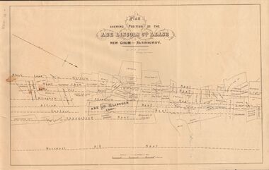
Document - MARKS COLLECTION: ABE LINCOLN CO LEASE
Two copies of plan for Abe Lincoln Co. Lease, New Chum, Sandhurst. One original, one copy. On top of plan 'Plan Showing Position of the Abe Lincoln Co. Lease, New Chum, Sandhurst' under name 'by H.B. Nicholas, Mining Surveyor' Sheepshead Reef, Easter reef, Alfred Reef, Allingham Reef,Adventure Reef, Belle Vue Reef, New Chum Reef, Black Lead, Victoria Reef lines shown on map with mine leases marked. On bottom of map 'Monument Hill Reef' line marked.bendigo, mining, abe lincoln lease -
 Bendigo Historical Society Inc.
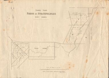
Document - MARKS COLLECTION: MAP OF PARISH OF STRATHFIELDSAYE 1858, 8th September, 1858
... Inc. History House 11 Mackenzie Street Bendigo goldfields MAP ...Buff coloured document. On top 'Country Lands, Parish of Strathfieldsaye, County Unnamed'. On bottom 'Scale 40 chains to an inch. Public Lands Office, Melbourne Sept 8th. 1858. William Collis, Lith ( lithographer )'. Map shows Village Reserve on Emu Creek, road from Sandhurst, Sheepwash Creek and Splitters Creek. Wellington Hotel marked on map near intersection of Sheepwash Creek, Axe Creek and Emu Creek. Axe Creek Pound near Splitters Creek.map, bendigo, parish of strathfieldsaye 1858 -
 Bendigo Historical Society Inc.
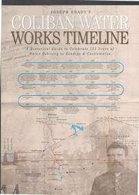
Document - JOSEPH BRADY COLLECTION: COLIBAN SYSTEM OF WATER WORKS PAMPHLET
... Delivery to Bendigo & Castlemaine Map of System Coliban Water Three ...Three copies of Joseph Brady's Coliban System of Water Works - A Historical Guide to Celebrate 125 Years of Water Delivery to Bendigo & Castlemaine by Coliban Water. Mentioned in the brochure is Gold & Water, The Original Coliban System of Water Works, The Coliban System Today, The Coliban Engineer - Joseph Martin Brady (1828 - 1908), Coliban System of Water Works Key Facts & Figures, The Aqua Project, Historical Guide, Coliban System of Water Works Map, photo of Joseph Brady, Photo of gold diggers and channel works.Coliban Watercivil engineering, water supply, coliban, joseph brady's coliban system of water works, coliban water, the original coliban system of water works, the coliban system today, joseph martin brady 1828 - 1908, gavan prendergast, coliban system of water works key facts & figures, the aqua project, historical guide to 125 years of water delivery to bendigo & castlemaine, map of system -
 Bendigo Historical Society Inc.
Map - MARKS COLLECTION: GEOLOGICAL MAP OF IRELAND
... PERSON Bendigo george lansell Rolled map on wooden hanger ...Rolled map on wooden hanger, woodern rail on bottom. On top of map: 'geological survey of Ireland' On bottom LH side: the geology of this map published June 1855 by Sir R.I. Murchison, Director General, J. Beebe Jukes Local Director, surveyed by T. Oldham. Map part of Lansell material. On back of map at top written in black pen 'Treland'.person, bendigo, george lansell -
Bendigo Historical Society Inc.
Document - MARKS COLLECTION: BOUNDY'S FREEHOLD GOLD MINES MALMSBURY
Plan/advertisement 1888 for the sale of the Boundy's Freehold Gold Mines Malmsbury, 260 acres of auriferous and arable freehold land. Document contains map of mines, names include O'Connors Freehold Company, Egyptian Company, Queen's Birthday Company, No.1 South Queen Company, Madam O'Connor's company, Extended South Queen's Birthday Company. Scale 10 chains to one inch. Taken from Mr. H. Archdale's Plan by Walter Sleeman, Mining Mgr., Oct 9th. 1888. On RH side of map Daylesford Road to Malmsbury marked. The land is only about two miles from the Malmsbury railway station. On back of document letter from Henry Nutman, Mining Manager, Queens Birthday Company; Report on Plan Walter Skleeman, M.M.; letter to S. Deeble, 35 Queen St., Melbourne with report on mine from George Jenkyn and Mining Manager's Report in Argus 24th.October, 1888.mine, gold, boundy's freehold gold mine -
Bendigo Historical Society Inc.
Document - MARKS COLLECTION: MAP OF VICTORIA REEF MINING CLAIMS
Copy of map. On bottom LH side of plan Plan of the Victoria Reef Sandhurst January 1867, Compiled by G.W. Hart, Mining Surveyor. Published by John N. Macartney, Argus Agent, Sandhurst. Price 4/- each On bottom Rh side J.W. Pearson & Co. Lith. Melbourne Plan shows mining claims and names of holders, scale ( 4 chains to one inch ) Loddon Road, Mount Korong Road, Ironbark Gully, township of Long Gully, Quartz Miners' Arms and Gold Mines Hotel on Loddon Road.bendigo, mining, victoria reef plan -
Bendigo Historical Society Inc.
Plan - MARKS COLLECTION: LANSELL'S 180 PLAN, LEVELS 18, 19 AND 20
Plan of underground section of Lansell's 180 mine, levels 18, 19 and 20. On RH side of map Victoria Quartz Mining company claim marked, on LH side North Old Chum Co. 'West or hanging wall' marked above each level.bendigo, mining, lansell's little 180 mine -
Bendigo Historical Society Inc.
Document - MARKS COLLECTION: MINING LEASE BLOCKS 1873
Plan mining lease blocks 1873, timber hanger on top two brass rings, securing tape, round timber holder on bottom, scroll. On top Schedule of Mining Lease Blocks shown on the plan of the Sandhurst Gold Field, Published May 1873' Names of mining Companies listed with identifying number and area of mine site. E.g. '447 Johnson's Reef Gold Mines 7a, 2r, 8 p ( acres, roods, perches ). Number linked to the mine site shown on Sandhurst Gold Field map.bendigo, mining, mining lease blocks 1873 -
Bendigo Historical Society Inc.
Map - MARKS COLLECTION: MAP MINES BALLARAT AREA 1887
... Inc. History House 11 Mackenzie Street Bendigo goldfields MAP ...Large buff coloured map, wooden strip on bottom, top hanger missing, showing mine boundaries in Ballarat mining area. Mines include: from top of map Bonshaw No. 1; Band and Albion Consolidated Company; Central Bonshaw; North Bonshaw; Star of the East block Claim; Star of the East; South Star; Owen's Freehold; Central Plateau; Sebastopol Plateau Company; Sebastopol Star; Sebastopol Plateau No. 1; South Plateau; Prince of Wales; Bonshaw United company; Gay's Freehold. Map prepared by Robert Alan, under the direction C.W. Langtree, Secretary for Mines, and Chief Mining Surveyor.map, ballarat, ballarat, mining, goldmining -
Bendigo Historical Society Inc.
Document - MARKS COLLECTION: PARISH PLAN OF WHITE HILLS
Sepia coloured map showing allotments in Parish of Sandhurst (White Hills) Written on LH side of map town and Suburban Lots White Hills Parish of Sandhurst. Scale is shown in chains. Surveyed by Horage Walker. Photo lithographed at the Department of Lands & Survey, Melbourne by J.Noone, Price 1/-. 6th. January 1865. Map shows Race Course Reserve at top of sheet, Municipal boundary is marked on LH side. Comments re vegetation throughout map. E.g poor soil timbered with Box scrub.bendigo, planning, white hills parish map -
 Bendigo Historical Society Inc.
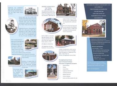
Document - EAGLEHAWK HERITAGE SOCIETY INC BROCHURE
Coloured brochure which contains a brief history of Eaglehawk, opening times for the Museum, a map with points of interest, application for Membership form, a brief history of the Museum, where Publications can be obtained and Research and Displays.eaglehawk heritage society inc brochure, former eaglehawk court house, log lock up, eaglehawk borough council, city of greter bendigo, court of petty sessions, eaglehawk newsagency, eaglehawk post office -
 Bendigo Historical Society Inc.
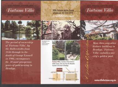
Document - FORTUNA COLLECTION: FORTUNA VILLA
Coloured tri-fold brochure titled Fortuna Villa. There are several coloured photos of the Villa and garden, a short history, information on the Villa Fortuna Action Group and their ideas for its future use. There is also a printed membership form. A small location map is included.bendigo, clubs, fortuna villa, christopher ballerstedt, theodore ballerstedt, 180 mine, george lansell, edith lansell, william beebe, vahland, getzschmann, emil maumann, commonwealth department of defence, the fortuna villa action group, city of greater bendigo, julian prowd, geoff hocking, bart-n-print -
 Bendigo Historical Society Inc.
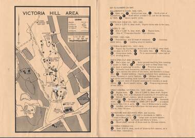
Map - VICTORIA HILL AREA
... Inc. History House 11 Mackenzie Street Bendigo goldfields MAP ...Map of Victoria Hill Area printed on yellow paper. Details of tracks, cuttings, contours (in Metres) and Anticline. Location of mines, open cuts and buildings are shown. Numbers on map are: Ballerstedt's Claim 1 - 5; North Old Chum Co. 6; Lansell's 180, 7,8,11; Battery 9.10.12; Victoria Quartz Co. 13 - 17; Rae's Open Cut and Vicinity 18 - 28, Great Central Victoria Co 29 - 36, Adventure and Advance Area and vicinity 37 - 40 and Victoria Consols Co 41.map, bendigo, victoria hill, victoria hill area, victoria consols, new chum anticline, great central victoria, rae's open cut, w rae's home, victoria quartz, ballerstedt's open cut, lansell's 180, north old chum, central nell gwynne, john brown factory, gold mines hotel, cleopatra needle type chimney, floyd's battery, ballerstedt's 24yd claim, humboldt shaft, wittscheibe's jeweller's shop, luffsman and sterry's claim, victoria hill reserve, mines dept reervation -
 Bendigo Historical Society Inc.
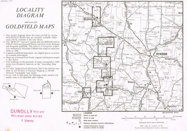
Document - JOAN O'SHEA COLLECTION: LOCALITY DIAGRAM AND NOTES FOR DUNNOLLY GOLDFIELD MAPS
Joan O'Shea Collection. Locality diagram and notes for goldfield maps. Dunolly map set. Wedderburn, Berlin, Dunolly, Maryborough, Avoca.mining, company exploration, dunolly map set. -
 Bendigo Historical Society Inc.
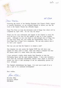
Document - MERLE HALL COLLECTION: CORRESPONDENCE FROM BENDIGO REGIONAL ARTS CENTRE
Correspondence from Bendigo Regional Arts Centre to Merle Hall, Sec Arts Bendigo - 25th Oct (1988) re work to Capital Theatre and Seat Donation; 6 December 1988 re donation from AB of $3000 to Capital Theatre project; November 12 1993 re donation from AB as contribution towards cost of purchasing a map cabinet - handwritten note on letter re the amount of that cheque ?? And comment that the donation never shown in the plaque on the cabinet; 20 June 1997: Reconciliation of the Soul Food recital of Gudrun Beilharz and Peter Bartels (loss). -
 Bendigo Historical Society Inc.
Document - HERITAGE REPORT: FORMER POLICE STATION AND QUARTERS: CALIFORNIA GULLY
Seventeen page Heritage Place Report on the Former California Gully Police Station at 15 Thorpe Street, California Gully. It is the former police station and quarters, former timber stables and timber cottage residence demolished and horse paddock on separate title. Report includes a Statement of Significance, Place History (History of the Area), Policing California Gully Goldfields, History of the Buildings, Chronology of Ownership, Rate Books 1858, - 1867 - 1868, 1895 Borough of Eaglehawk Rates, 1922 Voters Roll, 1952 & 1962 Sands & McDougall Directory Thorpe St California Gully, Comparable Examples, Secondary Sources, Description Conservation Policy Guidelines (Specific), Physical Conditions, Physical Description 1, Map of Early Photo Location, Bendigo Parish Plan circa 1870, Certificate of Title 1950 & 1960. Pge 14 has plans, maps and an aerial photo of 15 Thorpe Street. Page 15 has an aerial photo of 15 Thorpe Street, California Gully with Allotment Size. Page 16 & 17 has photos.heritage, heritage report - former police station and quarters - california gully, city of greater bendigo, wilson & ass, butler, amanda jean, johnson reef shafts no 1 & 2, rose of denmark, princess dagmar, bendigo amalgamated goldfields company, captain frederick standish, royal irish constabulary, e thorpe, campbell, taylor, watson, brown, hosken, mckowne, mcqualter, parker, hicks, eaglehawk municipal council, victorian police force, d bannear, historic mining sites in the sandhurst eaglehawk and raywood mining divisions, department of conservation and natural resources, joshua thorpe, thorpe & co, johnson & co, william thorn, michael thomas, james murdock, edward c brown, francis youlden, gold escort, water police, mounted police, city police (melbourne), geelong police, gold fields police, rural bench constabulary, the people's force, robert haldane, n wild, streets of the borough of eaglehawk, police registration act, william henry mitchell, camp hotel, j o c nieman, j m catarach, g w hosken, margaret hosken nee mckown, majorie alice mcqualter, kellie anne mcqualter, adam joseph doolan, mr hicks, sands & mcdougall, hill george, meeking howard, mcewan frank a, jinks stanley, mccaig mrs eleanor, gordon john l, mcqualter mrs adeline, maher william l, raynor robert, flack john p, whitehead miss a, sang george t, linddsay john p, dyer henry, jackman george a, tibbetts mrs s a, hosken mrs margaret winifred nee mckowne, chaplin frank w, wilson c e, wright george, miller g a, sheyhill basil hugh, marshall r, miles j h, parker w b, barkla w g, nicholls les, cartledge clifford william, cole charles basil, farmers citizens trustees co, bev hanson -
 Bendigo Historical Society Inc.
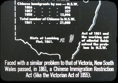
Slide - DIGGERS & MINING. THE CHINESE ON THE GOLD FIELDS, c1850s
Diggers & Mining. The Chinese on the Gold Fields. Slide: Map of New South Wales. Chinese immigration by sea - N.S.W. 1856 - 896, 1857 - 327, 1858 - 12,096. Total number of Chinese in N.S.W. 1861 - 21,000. Riots of Lambing Flat, 1861. Act of 1861 the working out of alluvial fields solved the problem in N.S.W. Faced with a similar problem to that of Victoria, New South Wales passed, in 1861, a Chinese Immigration Restriction Act (like the Victorian Act of 1855). Markings: 10 994:LIF I. Used as a teaching aid.hanimounteducation, tertiary, goldfields -
 Bendigo Historical Society Inc.
Slide - DIGGERS & MINING. THE CHINESE ON THE GOLD FIELDS, c1870s
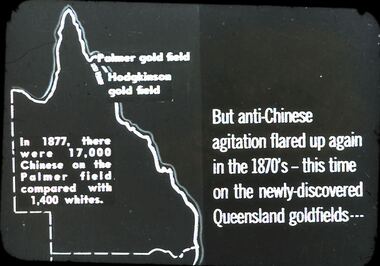
Diggers & Mining. The Chinese on the Gold Fields. Slide: But anti-Chinese agitation flared up again in 1870's - this time on the newly-discovered Queensland goldfields . . . Map on left is of Queensland: Palmer Goldfield, Hodgkinson gold field. In 1877, there were 17,000 Chinese on the Palmer field compared with 1,400 whites. Markings: 7. Used as a teaching aid.hanimounteducation, tertiary, goldfields -
 Bendigo Historical Society Inc.
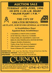
Document - IAN DYETT COLLECTION: AUCTION CATALOGUE - THE CITY OF GREATER BENDIGO
Bright yellow auction catalogue with black printing for a sale on 18th June, 1996 for the City of Greater Bendigo, AH Plant, Surveyor General & Others at Strathfieldsaye Depot, Strathfieldsaye. For sale were Earth moving equipment, tractors, 3 P/L equipment, caravans, various mowers, chippers,shredders, brush cutters, trailers, scrap, tools, Surveyors equipment, office furniture & computer equipment, drums of bitumen and R/C concrete drains. J. H. Curnow & Son P/L were the auctioneers. Map of how to get to auction site inside front cover. Loose pink Supplementary List, account Coliban Water listing backhoe/F.E. loaders, tractor, tipper crane and 4WD wagon listed.business, auctioneers, j h curnow & son pty ltd, ian dyett collection - auction catalogue - the city of greater bendigo, ah plant, surveyor general & others, darryl young, ian dyett, j h curnow & son p/l, coliban water, noel dyett, fred dyett -
 Bendigo Historical Society Inc.
Slide - DIGGERS & MINING. DIGGERS AND MINERS, c1850s
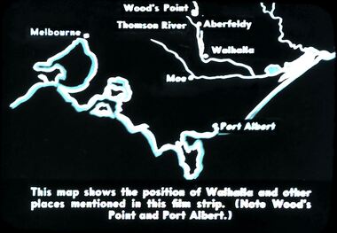
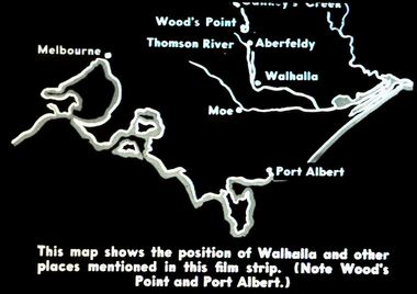
Diggers & Mining. Diggers and miners. Walhalla - Gold Town. This map shows the position of Walhalla and other places mentioned in this film strip. (Note Wood's Point and Port Albert.) Markings: 6 995 WAL. Used as a teaching aid.hanimounteducation, tertiary, goldfields -
 Bendigo Historical Society Inc.
Slide - DIGGERS & MINING. DIGGERS AND MINERS, c1850s
Diggers & Mining. Diggers and miners. Walhalla - Gold Town. This map shows the position of Walhalla and other places mentioned in this film strip. (Note Wood's Point and Port Albert.) Other places on map; Melbourne, Moe, Thomson River, Aberfeldy. Markings: 5 995 WAL. Used as a teaching aid.hanimounteducation, tertiary, goldfields -
Bendigo Historical Society Inc.
Document - IAN DYETT COLLECTION - AUCTION CATALOGUE - MORNING STAR GOLD MINE
Two red covered catalogues for auction sale at the Morning Star Gold Mine at Woods Point (Vic.) on 7/4/1954. Catalogue contains a locality map of Woods Point with note about accommodation at the Woods Point Hotel, the Men's Mess or hotel accommodation in the nearby towns of Gaffney's Creek, Kevington and Jamieson.Lots sold include Diesel and Steam Operated Alternator Sets, Babcock and Wilcox Boiler, 130-H.P. Diesel Engine, Elect. Motors, Stores and Valuable Accessories. Auctioneers were J. H. Curnow & Son Pty. Ltd.ian dyett collection - auction catalogue - morning star gold mine, state electricity power, j h curnow & son pty ltd, prahan telegraph printing co, woods point hotel -
 Bendigo Historical Society Inc.
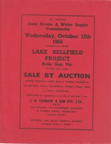
Document - IAN DYETT COLLECTION: AUCTION CATALOGUE - LAKE BELLFIELD PROJECT
Two copies of red covered auction catalogue for sale on account of State Rivers & Water Supply Commission held on 12/10/1966 Lake Bellfield Project, Hall Gap, Vic. Lots include motor vehicles, corr. Iron & timber buildings, machinery, tools, equipment, stores, scrap iron & steel and furniture. J. H. Curnow & son Pty. Ltd. Were the auctioneers. Catalogue has a map from Melbourne & Geelong to site near Hall's Gap and an Auction Layout sketch.business, auctioneers, j h curnow & son pty ltd, ian dyett collection - auction catalogue - lake bellfield project, state rivers & water supply commission, j h curnow & son pty ltd, f c dyett, l c osborne, c hill -
 Bendigo Historical Society Inc.
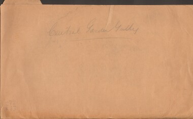
Document - MCCOLL, RANKIN AND STANISTREET COLLECTION: CENTRAL GARDEN GULLY
Manilla Folder containing correspondence and applications for a mining lease on the Garden Gully Line known as Mumford's Claim, also contains maps of lease numbers 9993, 10173, and 10390 (all on the Garden Gully Line).McColl Rankin & Stanistreet, Charing Cross Bendigogold mining, miners' safety cage, central garden gully, mining, gold mines, bendigo, garden gully, mumfords claim