Showing 15696 items
matching docuents-maps-france
-
 Greensborough Historical Society
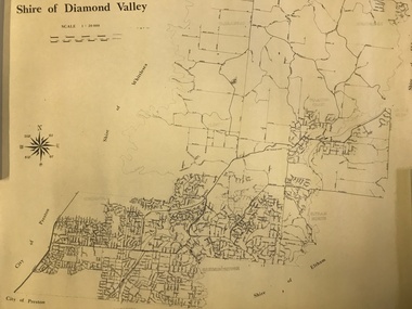
Map, Shire of Diamond Valley, 1964-1994
Map of the former Shire of Diamond Valley, 1964-1994, showing the local government area from Greensborough to Hurstbridge.Map on yellowed paper.shire of diamond valley, greensborough, hurstbridge -
 Greensborough Historical Society
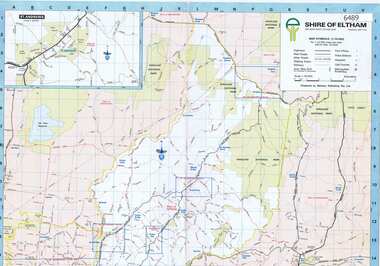
Map, Shire of Eltham, 1990c
1:20000 map of Shire of Eltham, with enlargements of a number of areas.Colour map, printed both sides.shire of eltham, eltham -
 Friends of Ballarat Botanical Gardens History Group
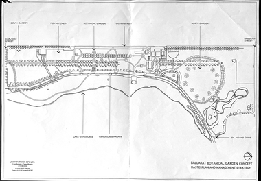
Work on paper - Ballarat Botanical Garden Concept, Masterplan and Management Strategy, Unknown
... Maps ...This map is important in terms of the planning and management of the Ballarat Botanic Gardens The Map adds to our understanding and knowledge of the history of the Ballarat Botanical Gardens 1 page of a map in black and white. the number 44 is circled in pencil on the top righthand corner of the back of the page.john garner, doctor, john garner collection, ballarat botanic gardens, maps, masterplan, management strategy, john patrick, landscape consultants, ballarat city council, friends of ballarat botanical gardens, gardens, ballarat -
 Melbourne Legacy
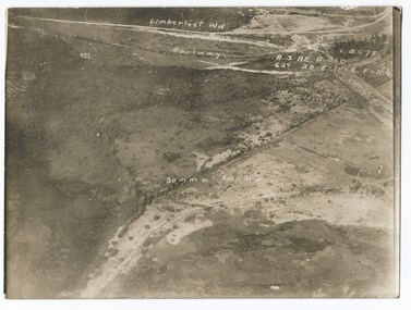
Photograph - Photo, Aerial view of the Somme
An aerial photo of the Somme Swamp in France during World War One. There are coordinates or numbers in some areas. Also labelled are the railway line and Canal du Nor and Limberlost Wood. Was with 11 other photos of World War One that had been mounted on board for display at Legacy House at some stage. When they were taken off display they were put in the archive cabinets. The founding legatees all served in World War One so these photos would have been of significant places for them. (see 01888 to 01899)Photos from World War One that would have been significant to the founding legatees.Sepia photo of the Somme battlefield in France during World War One.world war one, france, somme -
 Federation University Historical Collection
Photograph - coloured, Department of Lands and Survey, Portion of Victoria showing auriferous areas and mineral localities, 1935, 1935
Map included with book "Victoria: Gold and Minerals" issued by Mines Department Victoria, 1935Fold out coloured mapYellow mark indicating depositsvictoria, auriferous areas, mineral localities, department of mines, tin, antimony, copper, silver lead, tungsten, manganese, platinum, iron -
 Victorian Aboriginal Corporation for Languages
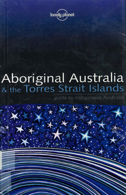
Book, Sarina Singh, Aboriginal Australia & the Torres Strait Islands : guide to Indigenous Australia, 2001
Comprehensive text with maps, coloured photos etc., dealing with all of Indigenous Australia. Provides historical references. Details of the Mabo finding.maps, b&w photographs, colour photographs, illustrations, word listsculture, travel guide, tourism, art, food -
 City of Kingston
Pamphlet - Colour, S. M. Reynolds, Estate Agent, Moorabbin Shire Hall Estate Second Section, c. 1930
Sales plan for land in the suburb of Moorabbin, bounded by South Road and Highbury Street, including Prince Street, Charming Street, Thomas Avenue and Keith Road.The developing urban area of Moorabbin within the City of Kingston. This land sale pamphlet illustrates the subdivision of land within the municipality and the changing demographic of the district as new houses are constructed close to infrastructure.Colour pamphlet advertising for private sale the Moorabbin Shire Hall Estate, Moorabbin. Incorporates a map of the estate bordered by South Road and Highbury Street, including Prince Street, Charming Street, Keith Road and Thomas Avenue.Handwritten in grey pencil on subdivision map below subdivision 63: £4 Handwritten in grey pencil on subdivision map below subdivision 66: 4 Handwritten in grey pencil on subdivision map below subdivision 80: 3. Handwritten in grey pencil on subdivision map below subdivision 81: 4 Handwritten in grey pencil on subdivision map below subdivision 83: 2 Handwritten in grey pencil on subdivision map below subdivision 96: £3 Handwritten in grey pencil on subdivision map below subdivision 97: 3 Handwritten in grey pencil on subdivision map to the left of subdivision 102: 3 Handwritten in grey pencil on subdivision map on the corner of Thomas Avenue and Highbury Street: vertical line next to a square with a cross in it.land sales, estate, moorabbin -
 Supreme Court of Victoria Library
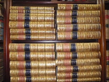
Books, Chronicles; Historical Chronicles, Early 19th Century
These are 22 volumes of early English and French History translated from the Latin, French and Old English. The volumes were published in the early 19th Century, Redmond Barry purchased these from Guillaume, Colonial Bookseller, Chester Square, London for the Library.The books are in excellent condition and would be rare in Australian library collections.22 Volumes of Leather Bound books with gold embossing, illustrated.Historical Chronicles of English History, many titles, translated from the Latin, and the Old English and Old French.redmond barry, chronicle -
 Wangaratta RSL Sub Branch
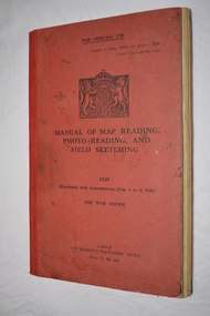
Manual - Book, Manual of Map Reading Photo Reading and Field Sketching, 1948
Official copy of War Office Manual of Map Reading Photo Reading and Field Sketching.Red bound book with black writing and British crest.Manual of Map Reading Photo Reading and Field Sketching 1929 The War Officemanual of map reading photo reading and field sketching., war office -
 Waverley RSL Sub Branch
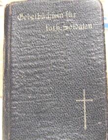
German Prayer Book , French Prayer Book and Christmas card 1918
German Prayer Book found on the Somme 10/08/1918 in dilapidated House (France) French Prayer Book found 14/4/1918 Found by Mervyn UnderwoodFrench Leather bound Prayer Book (RED) German Prayer Book ( Prayerbook for catholic soldiers) (Black) and Christmas card 1918 (from Mervyn with love 58th Batallion Christmas 1918 New Year 1919) -
 Stawell Historical Society Inc
Map - Electoral Map, Federal Government, map of Commonwealth Electoral Division of Wimmera 1949, 1949
Electoral MapMap overprinted with Electoral Divisions in Red. Description of Division of Wimmera Scale in Miles. Commonwealth of Australia State of Victoriagovernment -
 Bacchus Marsh & District Historical Society
Map, Maddingley Township, Parish of Parwan, County of Grant, 1856
Maddingley is a locality or township within the broader township area of Bacchus Marsh. This map is dated 1856 but is based on an earlier survey in 1843. The main area of Maddingley shown on this map is an area bounded by Bacchus Street, Moore Street, Griffith Street and Franklin Street. Other streets visible are Inglis Street, Labilliere Street, McCrae Street. The area to the east of Franklin Street is not sub-divided and is described as an 'alluvial flat. A single page paper map showing land allotments, streets, and natural watercourses in the township of Maddingley. The map is pasted into a bound volume containing 76 maps or plans in total. Two inscriptions: 1. A.J. Skene Surveyor, 1843. ; 2. Surveyor-General's Office Melbourne, Sept 6, 1856. (Lithographed by R. Meikle)bacchus marsh victoria maps, maddingley victoria maps, land use, maddingley victoria history -
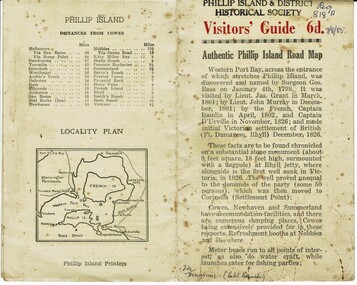 Phillip Island and District Historical Society Inc.
Booklet, Authentic Phillip Island Road Map, Pre 1960
Tourist brochure printed by the Phillip Island Printers pre 1960HistoricalSmall cream coloured brochure with details of accommodation, transport and animals. Inside is a map of the Island with numbered points of interest. There is also a plan of Cowes and drawings of animals.Visitors' Guide 6d Authentic Phillip Island Road Maptourist brochure, road map -
 Lara RSL Sub Branch
Map, Framed Map of the western front 1914-1918, Map made by G.F.Trudgion R.A.E. circa 1916
Map showing position of western front line in 1914 at the start of WW1Map is from circa 1916 showing battle area of the Western Front during WW1Map of the western front 1914-1918North West Europe Shewing the Western Front 1914-1918 War. Below is description of Australian ANZAC's on Western Front and a graph on Comparison of Casualties from Major Western Front Battlesmap, g.f.trudgion, r.a.e., western front, ww1, world war one, north west europe, 1914, 1916, ww1 casulaties -
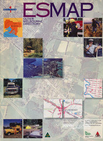 Eltham District Historical Society Inc
Book, Country Fire Authority Mapping Association Inc, ESMAP - Outer Melbourne Directory, 1991
Outer Melbourne directory of information for emergencies with maps of the state and major towns217 p. : maps ; 30 cm.ISBN 0646065661emergency services victoria -
 Greensborough Historical Society
Pamphlet, Lower Plenty Shopping Centre, 2007
Coloured pamphlet from Lower Plenty Shopping Centre with list of shops, map and 2008 CalendarColour pamphlet with calendar and maplower plenty shopping centre, calendars, lower plenty -
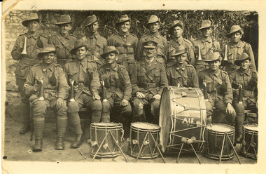 Federation University Historical Collection
Photograph - Postcard, 58th Battalion AIF Bugle Band, c1917, 14/07/1917
Horace Pickford was born at Clunes. His mother was Bessie and his wife was Ida. Horace enlisted on 22 June 1915. He was killed in action on 27 September 1917. He was buried in the vicinity of Polygon Wood. Horace was the brother of Edith Pickford ( m Holmes) and the maternal uncle of Elizabeth Mary Holmes ( m Chatham)Images relating to Australian World War One Soldiers from Ascot. . 2 Black and white carte postale of 17 Australian soldiers in uniform. Many hold a bugle and 5 drums are placed in the foreground. The Battalion colonel sits in the centre. The card was written by Horace Pickford (2282) of 'C' Company, 58th battalion. .3 Certificate of Marriage for Henry Robbins Pickford Family Tree .7 John Pickford Written in ink verso "France 14 July 17 Dear Edie I received your ever welcome letter a few days ago, this is but a card, but you will hear from other letters Ed. This is our batt bugle band, one of my friends belongs to it. I will march him out. Our colonel is in the center. Keep this little photo, it will be a little momento of the old battalion. We have a brass-band also. I have just received a letter from Ethel Pickford from England. Ta Ta now old kid with love. Horace (2882)chatham family collection, chatham, world war one, world war 1, france, horace pickford, ethel pickford, polygone wood, band, music, edith pickford, clunes, brass band, bugle band, henry robbins, family history, william pickford, charles pickford, elizabeth millard, sarah pickford, john pickford, alexander pickford -
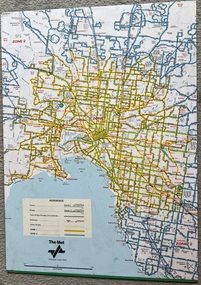 Melbourne Tram Museum
Map, The Met, "Tram and bus Routes showing destination numbers", June 1992
Titled "Tram Routes showing destination numbers". Map dated June 1992 and has been printed with The Met logo. Shows routes with route numbers, names of main destinations, roads, railway stations and rail lines, rivers, scales and Zones. Does not have the CBD insert. Same size as that of item 1099, a 1972 version. Type of map that was placed on the rear of the driver's doors of a W Class tramcar.Demonstrates a The Met produced map used in trramcars.Full colour map or poster printed on paper trimmed from original map and mounted on cardboard.Has some pen marks in the bottom left hand corner.trams, tramways, map, routes, the met -
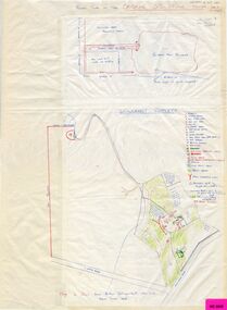 Whitehorse Historical Society Inc.
Map, Schwerkolt property and rough plan of old stone house, 1993
Map drawn by Arthur SchwerkoltMap drawn by Arthur Schwerkolt in 1993 from memory assisted by survey map of 1902. Covering letter from Glyn France [also at ND1367 (G-H-S-C 46) gives extra details.Map drawn by Arthur Schwerkoltschwerkolt cottage, schwerkolt, arthur, whalen, rosalie, france, glyn -
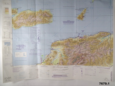 Bendigo Military Museum
Map - MAPS, EAST TIMOR, US Govt et al, 1975 - 1976
... Maps ...1. This is a coloured map. It's scale is 1.250,000 - called a jpoint operations graphic. It covers the North side of East Timor. Dili is in the centre. Its shows 4 Islands to the north of Timor. It shows Savu Fea, Ombai Strait, Wetar Strait. On bottom left of map it shows Batheade and the start of the New Border. Map - Series 159. Sheet 5C- 51-4. Edition 3-GSGS. 2. This is a coloured map. Its scale is 1.250,000 called a joint Operations Graphic. It manly covers West Timor. It shows Savu Sea in North and Timor Sea on south side. Series 1501. Sheet SC 51.7. Edition 3-GSGS. 3. This a coloured map. It's scale is 1.250,000. Joint operations graphic. This map shows the south side of East Timor and the Timor Sea. This map shows a highlighted New border. The major towns on South coast are KAMFNASA, BETANO. Map series 1501. Sheet SC 51-8. Edition 3 GSGS.1. Has highlighted "7 BSG" on coast. All maps show East Timor border highlighted in pink.east timor, maps, interfet -
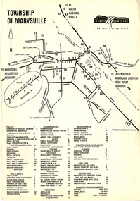 Marysville & District Historical Society
Flyer (Item) - Town map, Mystic Mountains Tourism, TOWNSHIP OF MARYSVILLE, Unknown
A map of the township of Marysville published by Mystic Mountains Tourism in Marysville. The map shows a legend of various services, accommodation sites, shops restaurants and recreation spots in the township.A map of the township of Marysville published by Mystic Mountains Tourism in Marysville.marysville, victoria, australia, mystic mountains tourism, map -
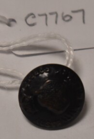 Tatura Irrigation & Wartime Camps Museum
Button, P J King Pty Ltd
Issued to Sister Kathleen Heaphy of Australian Army Nursing service. Sister Heaphy was attached, for part of her service, to 28 Camp Hospital Internment camp 1.round brass button with a metal shank. Crown and map of Australia and wording around the circumference.Australian Military Forces A crown and map of Australia P. J. King Pty Ltd Melbaustralian army nursing service, sister kathleen heaphy, 28 camp hospital internment camp 1 -
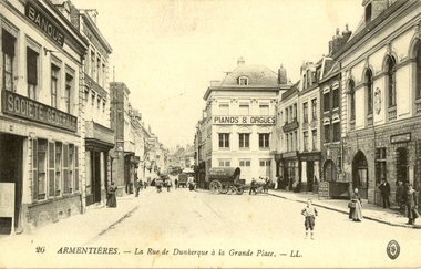 Federation University Historical Collection
Postcard - Black and White, La Rue de Dunkerque a la grand Place, Armentiers, c1916, c1917
Holmes Family WW1 memorabiliaA number of people stand in a street surrounded by double storey architecture.Verso: "Dear Willie, I promised to drop you a line, so he goes. Well at present I am in france having -a-go-at the Germans, and so far out Battery is getting on alright. But I must say the Germans greet us know and again with a few shells, and I can assure you they are no friends of mine. I have just been out watching the German anti-aircraft Guns shelling our Aeroplanes. it is a very lucky shot that brings one down. i have seen a little bit of the World since I left australia, And I must say I like france better than egypt. The country at present is looking very nice, it being Spring time, The grass is about 6 foot high, and nothing on it to eat it as most of the people have cleared out from around here. I have not seen anything of Harry over this way as yet. Perhaps he is still in Egypt. Well Willie now about taking another cow to Clunes. Ay What. The name on the front of this card should be familiar to you in the War news. Well Willie Au revoir for present. remember me to all. Your fond cousin, Ron W." chatham-holmes family collection, armentieres, world war one, postcard, clunes, france -
 Bendigo Military Museum
Postcard - POSTCARDS, PHOTOGRAPHIC, c.1912 - 1918
Black & white photos (postcards) of France mainly during WWI.Rectangular black & white cardboard postcards..6) From Herb Rumble dated France Dec 1912. .7) - .16) Handwritten message undersigned.documents-postcards, military history, passchendaele barracks trust -
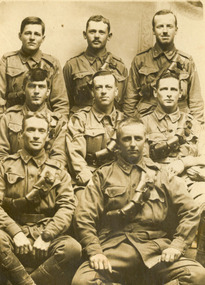 Federation University Historical Collection
Photograph - World War One soldiers, Members of 18th Company Australian Army Service Corps, c1916
HENRY SMERDON (Harry) HOLMES was born in 1897 at the family property, ’Sauchieburn’, 17 km north of Ballarat, in the Ascot district. He was the youngest of four children. After finishing his education at St Patrick’s College, Ballarat, Henry joined the Holmes family farming interests. At the age of 18 he enlisted and served with AIF in Egypt, France and Belgium 1915-1918. Henry served at the famous battlegrounds of Ypes and Somme in the Australian Army 8th Battalion. He was a Driver with the 4th D.A.C. The postcard is of "The Ascot" boys. Includes [Samuel] Gordon Spittle, Henry [Harry] Holmes's first cousin, and other Ascot lads and district connections: neighbours, Ascot State School classmates and football mates from Clunes / Creswick districts. [Research by a granddaughter of Henry Smerdon Holmes, Jane Dyer (nee Chatham) 2024] Ray Blight and Gordon Les Sim were former students of the Ballarat School of Mines. Les Sim was associated with Sim and Co. hardware and wood merchants). Eight soldiers of the AIF. They are the tent mates of Harry Holmes a Driver with the 5th D.A.C. The names of the soldiers are John Raymond (Ray) Blight, Joseph Fawcett, John Joseph (Jack) Nase, Gordon Spittle, Harry Holmes, Harold Joseph Reid, James Leslie (Les) Sim, Leslie John Walters. handwritten in pen on verso "This is a snap of our tent mates. Reading left to right. Back row, Jack Nase, Joe Fawcett, H. Reid. Middle - Les Walters, Ray Blight, Gordon Les Sim, (Sim and Co wood merchants) and Harryworld war 1, chatham, jack nase, chatham family archive, joe fawcett, h. reid, blight, sim, les walters, ray blight, gordon les sim, pickford, world war, gordon spittle, harry holmes, les sim, horace pickford, world war one, aif, armed services -
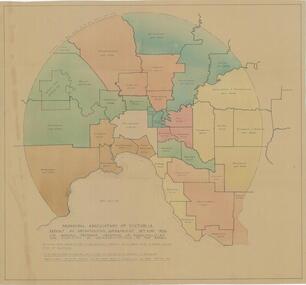 City of Whittlesea
Map - Maps, Municipal Association Of Victoria groupings of councils for representation, 1936
... Maps ...Map was produced as part of Municipal Association of Victoria report on Metropolitan Government, 18 May 1936. Map shows proprosed groupings of municipalities for election of representation to the MAV Board. Map includes net annual value of rateable property within each municipality. The net rateable value for metropolitan area of the Shire of Whittlesea in 1936 was £20,102. Maps, paper. Produced as part of Municipal Association of Victoria report on Metropolitan Government, 18 May 1936. Map shows proprosed groupings of municipalities for election of representation to the MAV Board. council, municipal association of victoria -
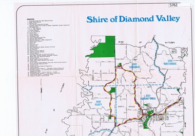 Greensborough Historical Society
Map, Map - Shire of Diamond Valley, 1990c
Map issued by the Shire of Diamond Valley showing location of key organisations and features Map printed in colour, one sideshire of diamond valley -
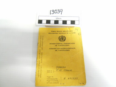 National Vietnam Veterans Museum (NVVM)
Booklet, World Health Organization
Yellow Booklet issued by WHO and featuring the Symbol of said Organization and International Certificates of Vaccination wording in black print. All wording in both English and French. 3790361 TM Collie in blue pen. Issued to passport number or travel document no G 495622Nine pages detailing dates and Vaccinations plus information for soldier and Physicians in both English and French. Some stamped.booklet, who, medical -
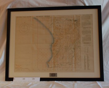 Montmorency/Eltham RSL Sub Branch
Map - Framed 1915 Anzac Cove Map, Gallipoli, 1915.ANZAC Cove Map, 1915
A framed map depicting trench lines and the battlefields of the Gallipoli Campaign, 1915, made by the Survey Department Egypt. Depth soundings of landing areas off Anzac Cove.Gallipoli - Anzac Cove World War One Map - 1915world war one, anzac, gallipoli, 1915, anzac cove, map, dardenelles, trench lines, depth soundings, landing areas -
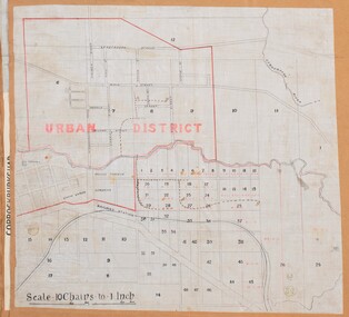 Bacchus Marsh & District Historical Society
Map, Bacchus Marsh Urban District
The date of this map has not been established but the date would be sometime after 1887 as the Bacchus Marsh Railway Station, which opened in 1887, is shown on the map. A single page paper map showing blocks of land in the urban district of Bacchus Marsh. The 'urban district' is indicated by red drawn lines on the map and includes streets and blocks on the northern side of the Werribee River in Bacchus Marsh, and streets and blocks south of the Werribee in Maddingley. Scale 10 chains to 1 inch. The map is pasted into a bound volume containing 76 maps or plans in total. High resolution digital image stored on BMDHS computer network. bacchus marsh victoria maps, maddingley victoria maps