Showing 1592 items
matching looking south
-
 Lakes Entrance Regional Historical Society (operating as Lakes Entrance History Centre & Museum)
Photograph, 1992
... looking to the south east shows low shrubbery on higher elevation... the base at the Red Bluff looking to the south east shows low ...Colour photograph taken from the base at the Red Bluff looking to the south east shows low shrubbery on higher elevation above sandy beach, surf breaking with ocean beyond Lake Tyers Victoriaocean, waterways -
 Federation University Historical Collection
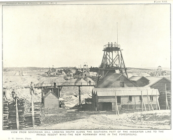
Book, J.W. Gregory, Memoirs of the Geological Survey of Victoria No. 4: The Ballarat East Gold-Field, 1907, 1907
... , Llanberres No. 1, Normanby North, North Woah Hawp Mine, View looking..., North Woah Hawp Mine, View looking south from the Britannia ...Blue soft covered report with 40 plates and plans. Inciudes Geology of Ballarat. Little Bendigo Goldfield, Ballarat West Goldfield, Ballarat East Goldfield, history, nuggets, indicators, faults, microscopic structure of Ballarat Rocks and ores, general type of the Ballarat East Mines and the genesis of their ores. Mines include New Zealand Trust, Llanberris No. 1, Llanberris No 2, Victoria United, Britannia United, New Britannia, Last Chance, Exchange, Normanby North, New Normanby, North Woah Hawp. Photpgraphic plates include: Victoria United Mine, Llanberres No. 1, Normanby North, North Woah Hawp Mine, View looking south from the Britannia Mullock Heap, View from Sovereign Hill, The place in Learmonth Street Golden Point where gold was first discovered at Ballarat. j.w. gregory, ballarat east, ballarat east goldfield, e.j. dunn, geolological survey of victoria, new zealand trust, llanberris no. 1, llanberris no 2, victoria united, britannia united, new britannia, last chance, exchange, normanby north, new normanby, north woah hawp, mining, indicators, gold mining, poppet head -
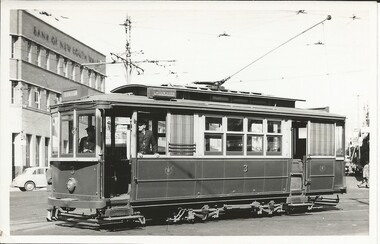 Ballarat Tramway Museum
Photograph - Digital image Set of 2, Doug Colquhoun, c1955
... Geelong looking south along Moorabool St, along with a Safety Zone.... Ryrie and Moorabool Streets Geelong looking south along ...Set of six digital images of Geelong trams photographed by Doug Colquhoun. .1 - No. 3 with destination of Station turning from Ryrie into Moorabool St with the Bank of New South Wales in the background. The conductor is watching the traffic. .2 - No. 4 - at the Railway Station or Beach terminus? .3 - No. 5 - in Ryrie St? .4 - No. 19 in St. with E. R. Sparrow & Co Auctioneer and Wool Broker building in the background - Moorabool St, tram has the destination of Beach. .5 - No. 23 with the conductor leaning against the bumper bar chatting to a man. Tram has the destination of North. Has a Kodak - E. A. O'Meara Chemist shop in the background. Ryrie and Moorabool Streets Geelong looking south along Moorabool St, along with a Safety Zone sign. .6 - No. 34 with the destination of Belmont.trams, tramways, geelong, ryrie st, moorabool st, conductors, north, beach, belmont, safety zone, tram 3, tram 4, tram 5, tram 19, tram 23, tram 34 -
 Ballarat Tramway Museum
Slide - 27 mm sq slide/s - set of 7, Lilian Butler, Mt Pleasant line, Sep. 1971
... at Stones Corner - Bridge St, Main Road .2 - Main Road looking south... looking south with Inland Body Works building on the left ...Yields information about the streetscapes of Stones Corner to Mt Pleasant route and in particular buildings and people that crewed the trams.Set of seven Colour 27 x 27 mm slide in a Kodachrome cardboard mount. .1 - Tram turning onto the Mt Pleasant line at Stones Corner - Bridge St, Main Road .2 - Main Road looking south with Inland Body Works building on the left and Ampol Service Station .3 - Mt Pleasant terminus with the butcher shop on the left and the diary on the right - shows the terminating tram track .4 - Conductor changing pole. .5 - Putting pole on the overhead .6 - Conductor (D O'Leary - No. 38) standing in front of tram and Motorman or driver (N. Hall - No. 43) .7 - ditto with number visible. See Reg item 3425 for crew lists. Slide mount date September 1971. Photo from the collection of Lilian Butler.ballarat, tramways, trams, stones corner, main road, mt pleasant, crews, drivers, conductors, trolley poles, tram 41 -
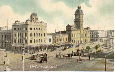 Ballarat Tramway Museum
Postcard, "Sturt St Ballarat", 1905
... the Post Office tower looking south west, with buildings... in the picture. Taken from the Post Office tower looking south west ...Printed colour postcard of an ESCo tram west bound at the intersection of Sturt and Lydiard St. Ballarat, c1905. Has a number of horse drawn vehicles and pedestrians in the picture. Taken from the Post Office tower looking south west, with buildings on the south side of Sturt St., west of Lydiard St in the view. Has the Robert Burns statue in the bottom left hand corner. Titled "Sturt Street, Ballarat" along the bottom edge. On rear of postcard are the words "Post Card", and guidance where the message may be written and space for the address. In the stamp section, details for Inland 1/2d stamp needed, and for Foreign 1d. On the bottom of the space for the stamp, has the words "Printed in Britain" See Reg Item 3151 for the same photo (slightly different position and different cloud effects), but different manufacturer. trams, tramways, esco, sturt st, postcards, lydiard st. -
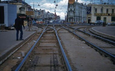 Melbourne Tram Museum
Slide - Set of 2, Keith Kings, 17/10/1959 12:00:00 AM
... . 1959. .1 - St Kilda Junction during reconstruction looking... during reconstruction looking south with the junction ...Set of two Colour slides, Kodak, white cardboard mount of track laying and reconstruction at St Kilda Junction during Oct. 1959. .1 - St Kilda Junction during reconstruction looking south with the junction arrangements shown. Has in the background, the Signal box, the junction hotel and the Corner Hotel, all with adverts for Penfold Wines, Fly ANA, Shell, Sepletts wins and Gilbeys Gin. Shows the vertical curves and the nature of the trackwork at this location. Photo 17/10/1959. .2 - ditto, but further back, with track welding, overhead work, tower wagon and a welding truck. In the background in addition to .1 are signs for Fosters Lager and Goodyear tyres. Dated 18/10/1959. Slide Number K(l)(293) and K(i)(293).Extensive handwriting on rear in ink and that it was photographed at 1/125 f4 and 1/125 f5.6trams, tramways, st kilda junction, overhead, tower wagon, welding truck, signal box, trackwork -
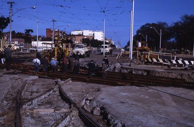 Melbourne Tram Museum
Slide - Set of 2, Keith Kings, 5/05/1968 12:00:00 AM
... new turnout for Fitzroy St. In new track looking south. Old... new turnout for Fitzroy St. In new track looking south. Old ...Set of two 35mm Kodak white cardboard colour slide by Keith Kings of 5/5/1968 .1 - construction of new curves from Fitzroy St and High St into St Kilda Road. Shows the old junction trackwork and road height differences. Note the temporary tram stop. .2 - ditto, shows the trackwork for High St behind the hotel and the Junction Hotel with a large Dunlop sign and Rothmans cigarette advert. See Keith's slide notes.Keith Kings stamp and number "23-27 and 23-28", with details of exposure. .1 - St Kilda Jtn by pass work. installing new turnout for Fitzroy St. In new track, New level is lower. Old curves replaced after a day's work to all normal service to resume during weekdays. .2 - St Kilda Bypass work. Installing new turnout for Fitzroy St. In new track looking south. Old Jtn out of photo to the left. New concrete track ready at rear on right. Hotel (which will remain in the middle of everything!!)trams, tramways, st kilda junction, fitzroy st, st kilda rd, trackwork, high st -
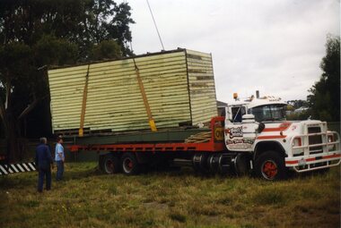 Ballarat Tramway Museum
Photograph - Colour Photograph/s, Carolyn Dean, Apr. 1999
... and partially painted fence looking south west. .18 - ditto looking... south west. .18 - ditto looking south. .19 - fitting off ...Set of 20 photographs taken by Carolyn Dean between 16/4/1999 and 16/5/1999 of moving the ex SEC bike shed to Bungaree and placing the roof back onto the shed and other works at Bungaree and one tram operation photo. On Kodak paper. 1095.1 - Loading the shed at Ballarat East - Alastair Reidier and Peter Winspur. .2 - ditto .3 - truck with shed on approach road to house. .4 - ditto and John Phillips .5 - lifting the shed into position at Bungaree over the power line. .6 - ditto .7 - lowering onto the foundations. .8 - tram 14 in Wendouree Parade near depot junction. .9 - Fixing hole in roof of the house - Bungaree - John Phillips .10 - ditto .11 - its snowing - Darren Hutchesson, Carolyn Dean, Alan Snowball - photo John Phillips .12 - putting roof back on the shed .13 - various cars out front of the house. .14 - nailing weather boards back on - Peter Winspur, Sftnon Jenkins, Alan Snowball .15 - ditto .14 used in the May 1999 Fares Please! .16 - fitting off purlins - Darren Hutchesson and John Phillips .17 - view of house and shed and partially painted fence looking south west. .18 - ditto looking south. .19 - fitting off the sheet metal - John Phillips .20 - cleaning up the tree in frost of the house from breaking off more branches - Alan Snowball and Alastair Reither. .1 > .7-16/4/1999: .8 - 25/4/1999: .9 > .16-15/5/1999: .17 > .20-16/5/1999. See also Reg. No. 1095 for next stage of the move.On rear of each photo in blue ink is date in the upper edge and on lower edge "Photo by Carolyn Dean"btm, sec bike shed, bungaree -
 Orbost & District Historical Society
coloured photographs, 1948 1954 ?
... Street / Salisbury Street intersection looking south... Street / Salisbury Street intersection looking south ...These photographs were probably taken in the late 1940s - mid 1950s. 3275.1 was taken at the roundabout in Nicholson Street / Salisbury Street intersection looking south. On the right is the The Commonwealth Hotel and the Gippsland Northern Store can be seen on the right. The war memorial can be seen in the centre of the intersection. 3275.2 has been taken from a height (possibly from behind the hardware store) overlooking Orbost House in McLeod Street. The butter factory can be seen in the background. Back yard toilets and paling fences can be seen with a narrow lane for the sanitary truck. Mrs Ruth Hannah Macalister, 1861-1932, established “Orbost House” as a boarding house in about 1900. Following her demise “Orbost House” was taken over by her son, “Reg” and his wife and they continued the Macalister family‟s association until the accommodation house was purchased by “Slim” and Eileen Somerville and Lindsay and Joan Jensen, in partnership, in 1963. (info. from Marilyn Morgan)These photographs are detailed pictorial records of Orbost in the mid 20th century. They show the objects in their spatial context with detail.Two coloured photographs. 3275.1 is a streetscape with a large hotel on the right, a main shopping area in the background and a wooden fence on the left. 3275,2 is overlooking backyards and fences. In the middle is an extensive red roof with "ORBOST HOUSE" in white print.on back - 1948-1954orbost-1950s orbost-house commonwealth-hotel -
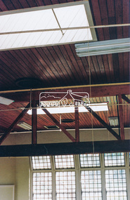 Eltham District Historical Society Inc
Photograph, Harry Gilham, Renovations to Eltham State School No. 209, Dalton Street, Eltham, 1994
... Looking to the south windows of the 1921 extension... melbourne Looking to the south windows of the 1921 extension ...Looking to the south windows of the 1921 extension - skylights were put in in the same time as the 1875 set. The heavy beam across the room carried the weight of the folding door track The bottom guide is in another photo).Handwritten (HG's) information and details in blue ink on reverse sidedalton street, eltham primary school, renovations, building construction, buildings, eltham state school no. 209 -
 Whitehorse Historical Society Inc.
Photograph, Narmara Primary School, 13/01/1994 12:00:00 AM
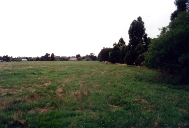
... Coloured photo of Narmara Primary School Site, looking East... photo of Narmara Primary School Site, looking East from South ...Coloured photo of Narmara Primary School Site, looking East from South East corner. North side of Highbury Road between Middleborough Road and Blackburn Road. Since demolished and site developed for housing.narmara primary school, warner, philip -
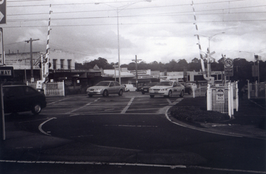 Whitehorse Historical Society Inc.
Photograph, Railway Crossing from the north, 1/06/2009
... , looking to the south of the shops. See NP 3545 to NP3567... of Springvale Road, Nunawading, looking to the south of the shops. See ...One of a collection of photographs taken of the Nunawading Railway Station prior to the lowering of the railway line and building of the new railway station on the western side of Springvale Road so that the Springvale Road Rail Crossing can be eliminated.Black & white photograph of the precinct surrounding the Nunawading Station and the Springvale Road Railway crossing. This photograph is of the railway crossing of Springvale Road, Nunawading, looking to the south of the shops. See NP 3545 to NP3567 for the complete set of photographsnunawading railway station, springvale road nunawading, redevelopment of railway line/springvale road. -
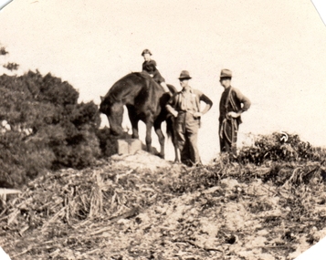 Williamstown Botanic Gardens- Hobsons Bay City Council
Photographs - Williamstown Botanic Gardens, 1936
... (i) ‘Panoramic view of Gardens / looking South from Lodge... (i) ‘Panoramic view of Gardens / looking South from Lodge ...Ernest Anderson (head gardener) and Harry (gardener) worked at Williamstown Botanic Gardens. The Anderson family lived in the curators lodge on the grounds in the 1930s. Horses were used at the gardens until the 1960s when the council bought a truck. Mr Biggs drove as Mr Anderson did not have a licence. He rode his bike to the Town Hall every Friday to put in the time sheets. The collection is the only known photos of the Gardens working horses and demonstrates Edwardian Municipal gardening techniques that continued into the 1960s. They are photographic evidence of the planting styles, species choices and structures. Details inscribed on the reverse of some of the photos confirm names of staff at this time. Photo 13 (m) m: Only known photo of Ernest Anderson to be held by the Gardens2013.001.a-l is a collection of 12 small format photographs from the Anderson family album dated from 1917-1936 plus one large image of donor's wedding c1953. Ernest Anderson (head gardener) and Harry (gardener) worked at Williamstown Botanic Gardens. The Anderson family lived in the curators lodge on the grounds in the 1930s. Photo 1 (a) Sepia photo of young girl (Chic Anderson) on horse with no saddle. Two men, with hands on hips, standing alongside wearing hats. All are on a small hill (a compost heap) with a shrub on the left of the image. Photo 2 (b) Young girl and horse standing on the top of a small hill (compost heap). Girl has short hair and is wearing a jumper, skirt and long socks. Horse has no saddle and has its head down as if to eat. Photo 3 (c) Horse and foal standing in a fenced enclosure. Part of yard is paved. Horse has a white blaze and white feet. Foal has white blaze and white legs and is looking up at the horse. Photo 4 (d) Horse pulling a mower. Two men standing with mower. One is holding mower, the other the reins of the horse. Both men are wearing hats, with one wearing a vest. Horse has hessian wrapping on his hooves. Photo 5 (e) Horse and man. Horse has a rope bridle. Man holding bridle and is dressed in trousers, shirt, cardigan and hat. They are in front of a hedge and closed timber gate. Tall palm is in background. Horse is side on to the camera. Photo 6 (f) Man and horse standing in front of hedge and open timber gate. Palms in background. Man wearing trousers, shirt, vest, tie, hat. Trousers look to be tucked into boots. He is looking at the horse. The horse is facing the camera. Photo 7 (g) Three horses looking over a picket fence. All with a white blaze. There is a timber wall with a window to the right of the photograph. A man’s arm holding something is seen on the right of the photo. Photo 8 (h) Large palm tree, understorey of shrubs with two palms in the background. Photo 9 (i) Scene of the Gardens. Path dividing at a conifer tree. Woman in long skirt and hat looking up at the conifer. Different varieties of palm trees with understorey of shrubs. Photo 10 (j) Garden bed of Dahlias surrounded by a wire fence. Palms and other trees in background. Photo 11 (k) Avenue of tall palm trees with under storey of shrubs. Photo has angles cut at top corners and two large crease marks at the bottom right hand corner. Photo 12 (l) Set of cast iron gates – double carriage gates with single pedestrian gates on either side and supported by four cast iron posts with ornamental finials on top. Photo 13 (m) Ernest Anderson and daughter Chic prior to her wedding. Ernest is holding his gloves in his left hand and Chic’s hand with his right. Palms trees in the background. Photo 1 (a) 'Ern & Harry / May 8th 1936' Photo 2 (b) ‘Jack aged 36 / Chic 5 years / (unclear) 1936’ Photo 3 (c) ‘foal born in / back shed’ Photo 4 (d) ‘The Olde Firm / Jack Ernie Harry / 1917’ Photo 6 (f ) ‘Before the / council provided / a truck all / work was done / with the horses’ Photo 7 (g) ‘our work horses’ Photo 9 (i) ‘Panoramic view of Gardens / looking South from Lodge / Wms Town Botanical Gardens / 15-10-17’ Photo 12 (l) ‘Gates Public Gardens’hobsons-bay-city-council, curator, lodge, horse, transport, dahlia, compost, anderson, williamstown, botanic, gardens, williamstown-botanic-gardens, hobsons-bay, hobsons, edwardian, gardening, 1936, 1917, -
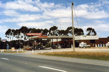 Charlton Golden Grains Museum Inc
Photograph, Charlton Roadhouse c. 1987
... the other side of the highway looking south east. The highway... taken from the other side of the highway looking south east ...The Charlton Roadhouse was established in the 1960s (TBC)Colour photograph of the Charlton Roadhouse taken from the other side of the highway looking south east. The highway is visible in the lower part of the photo. The roadhouse is a single storey building with large windows at the front. There is a large roof extending over the petrol pumps. There is a large sign on the roof which reads RESTAURANT. A brown coloured car with a white roof, dark bonnet and towing a trailer is facing toward the photographer. A man is getting the driver's side. A lighter coloured car is facing away from the photographer and a man is beside this car. There is a white Toyota utility parked on the right hand side of the roadhouse in front of the ice storage. There is a small sign for ESSO on the roof edge and a freestanding sign for ESSO close to the entrance to the roadhouse. There is a sign on wheels near the road reading NOW OPEN and another that reads L.P. GAS AUTO GAScharlton roadhouse -
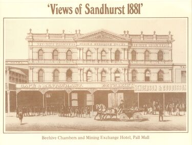 Bendigo Historical Society Inc.
Domestic Object - VIEWS OF SANDHURST 1881 CALENDAR, 1981
... the Post Office tower looking south to Golden Square.... shows a fine view from the Post Office tower looking south ...A 1981 Calendar of Sandhurst (Bendigo) in 1881. The front cover has many shots of the city including the Mining Exchange, the Fountain, the train station and many more. Second page, a, for January and February is a larger photo of the front of the Beehive Chambers and Mining exchange. Second photo,b, for the months of March and April is a view from Post Office tower looking north to White Hills. Third photo ,c, for the month of May and June is a photo of the Sandhurst Post Office in Pall Mall. Fourth photo, d, for July and August is a top view of the Sandhurst Railway Station. The fifth photo, e, for September and October is shows a very busy Alexandra Fountain with many people walking around it. The sixth photo, f, for November and December shows a fine view from the Post Office tower looking south to Golden Square.bendigo, history, city history -
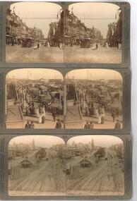 Ballarat Tramway Museum
Photograph - Black & White Photograph/s, Underwood & Underwood, 1908
... number (10)-10238 2 - Princes Bridge, looking south with many... Bridge, looking south with many people on the bridge, including ...Yields information about the appearance of the intersection of Sturt and Grenville St looking west and tram operations.Photographic reproduction - sepia coloured of a three stereo pair images with details on the sides. Originals made by Underwood and Underwood of Arlington New Jersey and Westwood New Jersey USA. Not dated, c1908 Printed on A4 size ink-jet printer. Set of three: 1 - Collins St at Swanston St looking west - tram has the destination of Victoria Bridge - image number (10)-10238 2 - Princes Bridge, looking south with many people on the bridge, including market stalls, horse drawn vehicles and cable trams. Has the Wirths Circus building and ?? Stationers and Printers building in the background. 3 - Sturt St from Grenville St with 3 ESCo trams in the photograph along with the Town Hall, the tramway shelter. The Mechanics Institute Building has the "Talk W to W Coltman" sign on it. Image no. - (34)-10262.trams, tramways, melbourne, cable trams, collins st, swanston st, princes bridge, sturt st, esco, shelters -
 Ballarat Tramway Museum
Photograph - Black & White Photograph/s, c1905
... . looking south east. Photo taken soon after opening as tram... office. looking south east. Photo taken soon after opening ...Black and white print with negative (N148) of an ESCo tram descending the Sturt St. hill from Lydiard St. North towards Grenville St. Photograph taken from possibly the post office. looking south east. Photo taken soon after opening as tram is not fitted with a destination box. Has horse drawn vehicle and person on bicycle travelling up hill alongside the tram indicating traffic arrangements at the time. Post office steps in photograph as well as Sutton store, Yankee Doodle store and Morris draper shop. Photo title "Sturt St. Ballarat". Another two tramcars at end of Bridge St. Copy negative and photograph by John Phillips of a Postcard High Res Images added 5/3/2011. Original neg scanned at hi res and updated 11/5/2020.trams, tramways, sturt st, esco, grenville st, bridge st -
 Ballarat Tramway Museum
Photograph - Colour Photograph/s - set of 6, Warren Doubleday, 12/12/1998 12:00:00 AM
... - Wendouree Parade at Depot junction looking south. .6 - Anita Bagley... junction looking south. .6 - Anita Bagley driving 26, northbound ...Set of six colour photographs taken by Warren Doubleday on 12/12/1998 of Museum activities and works. On Kodak paper. .1 - Depot Junction - showing road necking works at point were depot access track crossed Wendouree Parade. Photo used in Jan. 1999 issue of Fares Please! .2 - 26 southbound at Depot Junction, with conductor John Clowes boarding tram. .3 - 26 northbound at depot junction showing roadworks and BTM members. .4 - Alastair Reither and Simon Jenkins crossing four road at depot. .5 - Wendouree Parade at Depot junction looking south. .6 - Anita Bagley driving 26, northbound from Depot Junction with Alastair Reither and Darren Hutchesson standing along depot junction. Photo used in Jan. 1999 issue of Fares Please!On back of photos in ink "12/12/98"btm, depot junction, road works, tram 26 -
 Eltham District Historical Society Inc
Negative - Photograph, Construction of the new concrete bridge over the Diamond Creek on Main Road, Eltham, c.May 1926
... approach looking south east towards Eltham Park (Eltham Lower Park... approach looking south east towards Eltham Park (Eltham Lower Park ...Construction of the new concrete bridge over the Diamond Creek on Main Road, Eltham, c.May 1926. Viewed from northern approach looking south east towards Eltham Park (Eltham Lower Park), showing the power lines that used to run in front of the park. The original long suspension bridge over the Diamond Creek on Main Road at Eltham collapsed during flooding of the Diamond Creek on October 13 and 14, 1923. The original bridge was built around 1840 for the coach road when Cobb & Co.'s coach was the only conveyance between Eltham and Melbourne. Widespread damage was done in Melbourne and surrounding areas by floods resulting from the overflow of the Yarra at many points along its banks. A temporary bridge rigged up was severely damaged by the flooding of the creek and was closed to vehicular traffic in April 1924. A new concrete bridge was constructed to replace it and by May 1926 all the concrete piles and abutments had been completed. The bridge was finally completed and opened for traffic in September 1926, almost three years after it initially collapsed.This photo forms part of a collection of photographs gathered by the Shire of Eltham for their centenary project book,"Pioneers and Painters: 100 years of the Shire of Eltham" by Alan Marshall (1971). The collection of over 500 images is held in partnership between Eltham District Historical Society and Yarra Plenty Regional Library (Eltham Library) and is now formally known as the 'The Shire of Eltham Pioneers Photograph Collection.' It is significant in being the first community sourced collection representing the places and people of the Shire's first one hundred years.Digital image 4 x 5 inch B&W Negshire of eltham pioneers photograph collection, bridge, bridge construction, cement mixer, diamond creek (creek), eltham, eltham lower park, eltham south, main road bridge -
 Sunbury Family History and Heritage Society Inc.
Photograph, 17th December 1985
... Bendigo Railway line. The photograph looking towards the south... looking towards the south shows the extent of the flooding ...On the afternoon of the 17th December 1985 torrential rain fell in Sunbury and surrounding areas which resulted in widespread flooding and caused disruption on the main Melbourne Bendigo Railway line. The photograph looking towards the south shows the extent of the flooding at Sunbury Station.A coloured photograph of a railway station and the flooded tracks.sunbury railway station -
 Ballarat Tramway Museum
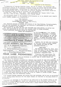
Document - Photocopies, Alan Bradley, "One Man Farebox cars, tokens and statistics of the Ballarat Tramways", 18/07/2001 12:00:00 AM
... . Includes a photograph of Barkly St. looking South from the fire... a photograph of Barkly St. looking South from the fire station tower ...Photocopies of an article written by Bob Prentice made by Alan Bradley in relation to the use of Fare Tokens by the Electric Supply Co. of Victoria - See Reg. Item 1794. Photocopies made 18.07.2001. Photocopy of the article from his collection. Comprises three sheets stapled together in top left hand corner. Article contains details of the use of tokens, colours of discs or lights used on trams while running on the various routes, fares, sections, fare box operation, and when and where tokens were issued. Includes a photograph of Barkly St. looking South from the fire station tower. Also gives details of tokens in use, cost of manufacture from other materials (Haxite and Crystalate) and the number in circulation. Has copy of an advertisement for the Southern Cross Hotel, S.A. Brabner, Proprietor, notes that all trams STOP. See Reg. Item 2514 for H.P. James notes on the token system.Parts of letter have been highlighted by Alan re tokens and other interesting points.trams, tramways, tokens, fares, tickets, esco, southern cross hotel, costs -
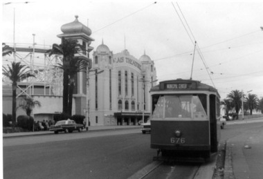 Ballarat Tramway Museum
Photograph - Black & White Photograph/s, 31/10/1965 12:00:00 AM
... - Hawthorn Road, just north of Balaclava road, looking south. SW6... of Balaclava road, looking south. SW6 869 alongside. 676 on temporary ...Set of three Black and white photographs on Kodak paper of an Association of Railway Enthusiasts tram tour with X2 676. The tour featured the use of a Washington DC destination roll. Date of Tour 31/10/1965. 1422.1 - X2 at the terminus of route 69/79 routes at the Esplanade, St Kilda. Note the track is alongside the north side kerb. Has Palais Theatre in the background and Luna Park. Tram showing destination of "Municipal Center" 1422.2 - Hawthorn Road, just north of Balaclava road, looking south. SW6 869 alongside. 676 on temporary track - during the reconstruction of Hawthorn Road - permanent track has been completed alongside. Tram showing destination of "Racecourse" 1422.3 - X2 676 on "Bang Road" Coldblo Road at Malvern depot entry looking east. Tram showing destination of "Friendship Hts". See P.Winspur notes, data sheet for Reg. Item 1418 and Dave Macartneytrams, tramways, tram tours, are, trackwork, mmtb, tram 676, tram 869 -
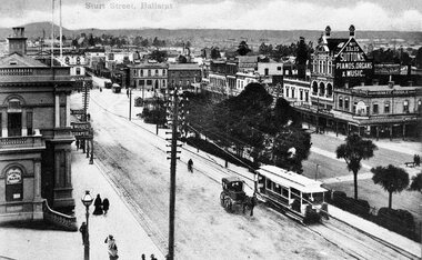
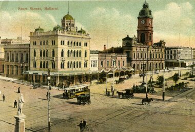 Ballarat Tramway Museum
Postcard, JE, "Sturt St Ballarat", 1905
... the Post Office tower looking south west, with buildings... in the picture. Taken from the Post Office tower looking south west ...Yields information about the appearance of SEC single truck trams during 1938. Has a strong association with Wal Jack.Printed colour postcard of an ESCo tram west bound at the intersection of Sturt and Lydiard St. Ballarat, c1905. Has a number of horse drawn vehicles and pedestrians in the picture. Taken from the Post Office tower looking south west, with buildings on the south side of Sturt St., west of Lydiard St in the view. Has the Robert Burns statue in the bottom left hand corner. Titled "Sturt Street, Ballarat" along the top edge. On rear of postcard are the words "Post Card", on either side of a symbol "JE" within a diamond, a 1d Victorian stamp. Divided back type. Address to Mrs, C. Harkneww 21 Alma St North Sydney NSW, from a person a 46 Grosvenor's St., South Yarra." Message includes words "what do you think of this street, none in Sydney like it" See Reg Item 2231 for the same photo (slightly different position and different cloud effects), but different manufacturer.trams, tramways, esco, sturt st, postcards, lydiard st., tram 18 -
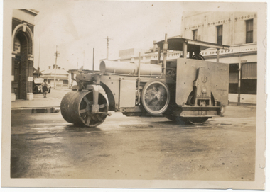 Ballarat Tramway Museum
Photograph - Digital image Set of 2, 1939
... a butcher shop. Note houses in the background, looking south along..., looking south along Peel St. Note known if a Wal Jack photograph ...Digital image from the Wal Jack Ballarat Album of the Jelbart roller at work in Bridge St, 1939 at the corner of Bridge St. In the background is the hotel and on the other corner a butcher shop. Note houses in the background, looking south along Peel St. Note known if a Wal Jack photograph as no details on rear. Wal's album notes "Ballarat Tramways Oil Roller Bridge St 1939" See image i2 for rear of photograph. See image i3 for hi res scan of print. See image i4 for hi res scan of negative with the lady. See the June 2010 issue of Fares Please! for an article written by Colin Holmes on Jelbart and the Ballarat roller. Added another very similar image of this scene 2-2-2020 following scanning of the original Wal Jack negs. .1 - has a lady in the view on the left hand side. .2 - without the lady - see image i5.No details on rear.trams, tramways, jelbart, road roller -
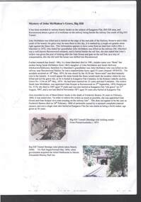 Bendigo Historical Society Inc.
Document - MYSTERY OF JOHN MCMAHON'S GRAVE BIG HILL
... Hill Tunnel (Bendigo side looking south) from Picture Australia... (Bendigo side looking south) from Picture Australia c. 1875 ...The Mystery of John McMahon's Grave, Big Hill mentions granite stone markers south of the Tunnel. Some believed he was buried there, but further research has found he is buried at the Kangaroo Flat Cemetery in the Roman Catholic section, Grave No. 1134 on 20 May, 1874. Also mentioned is his widow was appointed Gate Keeper at Ravenswood on 2 September, 1874. Also mentioned is the death of Frederick Benton, who died on 24 February, 1860 of peritonitis. There is a sepia? Photo taken of the Big Hill Tunnel (Bendigo side looking south) from Picture Australia c. 1875 and a coloured one of the Big Hill Tunnel Bendigo side (photo taken March, 2008). On page 2 are two coloured views at Big Hill for John McMahon, 850 metres south of Big Hill Tunnel entrance, Melbourne side/east of line (photos taken March, 2008).person, individual, john mcmahon, mystery of john mcmahon's grave, big hill, john mcmahon, big hill tunnel, mrs i marchesi, mr marchesi, mrs ivy irene marchesi (nee bone), sarah mcmahon, sarah mcewan (mckeown/mckeon), ravenswood station, kangaroo flat cemetery, sarah jane mcmahon, frederick benton, pictureaustralia, vic rail, melbourne to mount alexander-murray rail line, stone markers for john mcmahon -
Bendigo Historical Society Inc.
Photograph - MINING IN BENDIGO COLLECTION: MINING PHOTOGRAPHS
... , looking south in 1890's. Pictured is the Lazarus Crushing Plant... New Chum Hill, looking south in 1890's. Pictured ...Folded paper with copies of photos of mines and various mining buildings. On the front is a view from New Chum Hill, looking south in 1890's. Pictured is the Lazarus Crushing Plant and boiler house, Lansell's '222'. Amd the new Chum Mines in the background. On the inside at the top is the New Chum Railway, Golden Square. Pictured is the mine and its buildings, two chmneys, two large wood stacks and other mines in the background. On the left, a man is standing on the side of the railway line beside the mine. The next picture is the United Hustlers and Redan Mine, west of Comet Hill State School, Sandhurst Road. It shows the mine and its buildings, chimney, ore bins, mullock heap and tramway. The middle picture is the Central Deborah, Violet Street, near Bendigo Creek, Golden Square. It shows the poppet legs, buildings and some machinery behind the large building. The large building has eight ventilators in the roof. The buildings are made of corrugated iron. The bottom left picture is the Deborah Mine, Quarry Hill. The picture shows the poppet legs on the hilltop, the buildings beside it, a square chimney behind the poppet legs and some vegetation and a peppercorn tree in the foreground. The far building also has ventilators in the roof. The picture on the right is underground at 1000 feet level in the Deborah Mine. Pictured are three men with a rock drill. On the back, at the top is a picture of a First Motion Winding Engine at Deborah - later at Central Deborah. The picture shows the engine and driver. The middle picture is the South New Moon Mine, Eaglehawk - leading mine in State in 1903. The picture shows the poppet legs, buildings, chimney and a high tramway. In the foreground is a dam. The bottom picture is Victoria Hill looking south to New Chum Hill. In the foreground is Lansell's '180' Mine and Ballerstedt's Open Cut and in the background are the 'New Chum and Victoria', 'Old Chum' and the 'North Old Chum'.photo, mining in bendigo, mining photographs, lazarus crushing plant, lansell's 222, new chum mines, new chum railway, united hustlers and redan mine, comet hill state school, central deborah, deborah mine, first motion winding engine, south new moon mine, lansell's 180, ballerstedt's open cut, new chum and victoria, old chum, north old chum, square chimney -
 Surrey Hills Historical Society Collection
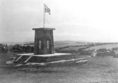
photograph, Ken Hall, Beckett Park Soldiers War Memorial c1932, c1980
... with the memorial in the foreground and looking to the south-west... with the memorial in the foreground and looking to the south-west ...Copy negative by Ken Hall from a c1933 City of Camberwell brochure. The original appears to have had a crease mark across it as this is evident on both copies.Black and white photo of the First World War memorial erected on the high point in Beckett Park, Balwyn. Taken with the memorial in the foreground and looking to the south-west. The Australian flag is flying on top of the monument and in the background are rows of trees dividing largely clear land.On the rear: Copy 1: "1153 Repeat of No 164" in top left hand corner in lead pencil in Jocelyn Hall's hand. Copy 2: "1153 Repeat of No 164" in top left hand corner in lead pencil in Jocelyn Hall's hand and "Soldiers War Memorial / Beckett Park / Erected 1918" in blue biro centre right.first world war, war memorial, beckett park -
 Melbourne Tram Museum
Photograph - Digital Image, Kevin O'Reilly, series of three images of the Hawthorn Bridge over the Yarra, c1930, c1930's
... , Richmond, Richmond 3 on the CD as original files. .1 - Looking..., Richmond, Richmond 3 on the CD as original files. .1 - Looking ...Image from CD (Compact Diskette for use in computers) - see Reg Item 135. A series of three images of the Hawthorn Bridge over the Yarra, c1930, during the era with problems with the bridge. See separate article for more details. Richmond 6, Richmond, Richmond 3 on the CD as original files. .1 - Looking from the south west, at the Hawthorn bridge with the temporary wooden bridge being constructed on the south side. Has the cable tram depot in the photo and part of the Burnley racing course. Temporary track on the north side of the steel bridge and crossings can be seen. .2 - Looking along Bridge Road to the east with Hawthorn Bridge in the middle of the photograph. Shows the industrial and residential areas, Hawthorn Railway Station and part of the Burnley Race course, the cable tram depot building. W class tram in Church St Hawthorn and W class tram crossing the bridge on the north side temporary track. Note the cable tram used as a shelter on the north east corner of the bridge. .3 - Looking south along River St towards Bridge Road, with the Yarra River and Hawthorn Bridge on the left side of the photograph. Shows the industry in the area at the time, wool and skin Merchants, north side of the cable depot, housing and the outlook to the river!trams, tramways, hawthorn, yarra river, burnley, richmond, hawthorn bridge -
 Eltham District Historical Society Inc
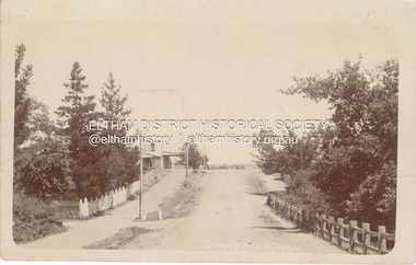
Photograph, Street view, Eltham, c.1907
... 05699) View looking south on Main Road towards Pitt Street... 05699) View looking south on Main Road towards Pitt Street ...Post card inscribed "Wishing you many happy returns of your Birthday from Flo" Florence May Shillinglaw Possibly sent to sister Carrie Watson for her birthday in February 1917 (see also 05699) View looking south on Main Road towards Pitt Street and Watson's Eltham Hotel on left See also EDHS_00136 POSTCARD 1905-1940s Like the carte-de-visite, postcards enjoyed a collecting craze by large numbers of people, and were often kept in albums through which the interested visitor could browse. Postcards were posted or exchanged in huge numbers. Postal authorities in Australia only allowed the private printing of postcards from 1898. At this time the back of the card was reserved for the address and postage stamp, and the front was used for the message and a picture. In 1902 British authorities allowed a "divided back", so that the left side could be used for the message, the right side for the address and stamp, and the whole of the front was devoted to the picture. France followed suit in 1904, Germany and Australia in 1905, and the United States in 1907. - Frost, Lenore; Dating Family Photos 1850-1920; Valiant Press Pty. Ltd., Berwick, Victoria 1991marg ball collection, postcard, 1907, eltham hotel, florence may bunker (nee shillinglaw) (1886-1969), main road, pitt street, watsons hotel -
 Federation University Historical Collection
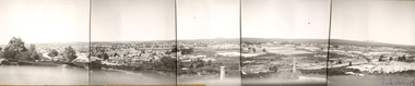
Photograph (Black & White), Keith E. Rash, Ballarat From Sovereign Hill Looking East, 1951
... Sovereign Hill and look towards the South East. Geelong Road.... The Photos were taken from Sovereign Hill and look towards the South ...Keith Rash was highly involved in research relating to Ballarat. He took this photo in the Gold centenary year.Six small black and white photographs have been taped together to form a panorama of Ballarat. The Photos were taken from Sovereign Hill and look towards the South East. Geelong Road is evident in the foreground. In the centre of the panorama is Mt Warrenheip, and to the right is Mt Buninyong. Stamped lower right 'K.E.Rash'ballarat, sovereign hill, ballarat east, keith rash, mount buninyong, mount warrenheip