Showing 1102 items matching "north-east victoria"
-
 Federation University Historical Collection
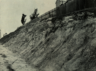
Book, Report on the Ballarat East Gold-Field, 1894 and Ballarat East Gold-Field, 1907, 1894
The Ballarat Ironworkers' and Polytechnic Association was at the Ballarat School of Mines. In 1907 J.W. Gregory Professor of Geology at Glasgow Univesity, Late Director of the geological Survey of Victoria and Professor of Geology at Melbourne University. W. Dickson was Secretary for Mines and Donald McLeod was the Minister of Mines. in 1894 Ernest Lidgey was the Assistant Geological Surveyor for the Victorian Department of Mines. A.W. Howitt was Secretary for Mines and Henry Foster was the Minister of Mines. Charcoal hard covered report on the Ballarat East Goldfield. The book combines two reports from the Victorian Department of Mines. The 1894 report is 52 pages and includes images and plans. The 1907 Report is number 4 in the Memoirs of the Geological Survey of Victoria. Photographs include Looking South from the Britannia Mullock Heap, View from Sovereign Hill, Golden Point gold discovery site.Stamped "Ballarat Ironworkers' Association School of Mines" Bookplate of the Ballarat Ironworkers' and Polytechnic Association. Written inside front cover: "S.J. Miller, 115 Ascot Street, Ballarat"ballarat ironworkers' and polytechnic association, ballarat school of mines, ironworkers, geology, mining, ballarat east, llanberris, victoria united mine, normanby, north woah hawp, bookplate, s.j. miller, library plate, golden point, gold discovery at golden point, new normanby mine, william baragwanath, new speedwell, britannia united, llanberris co, sulieman pasha, prince regent, dalzell-cum-prince regent, north prince extended, eastern star, f. gray, victoria united gold mine, sovereign hill mine, prince regent mine, britannia mine -
 Bright & District Historical Society operating the Bright Museum
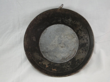
Pan gold
... East Victoria gold gold pan goldfields Used gold pan. 300mm ...Used for separating gold particles from alluvial deposits. After washing the alluvial gravel in water the gold is trapped in a ring on the side of the pan. This pan has a ring half way round the rim of the pan.Typical gold pan that would have been used in gold fields of North East VictoriaUsed gold pan. 300mm diametergold, gold pan, goldfields -
 Bright & District Historical Society operating the Bright Museum
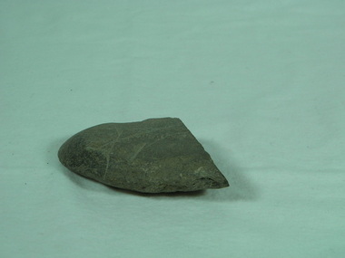
Axe Stone
... axes are relatively uncommon in North East Victoria and provide ...Presence of Aboriginal people and their activities in Buffalo RiverAboriginal axes are relatively uncommon in North East Victoria and provide evidence of presence and exploitation of resourcesground edge stone axe with some edge damage and edge polish on working edge and flat opposite edge. axe, aboriginal artefact, buffalo river -
 Federation University Historical Collection
Book, Historic Sites Survey: North Central Study Area, 1979, 1979
The North Central Study Area included the Shires of Avoca, Bet Bet, east Loddon, Goulburn, Untly, Kara Kara, Korong, Maldon, Marong, Metcalfe, McIvor, Newstead, Strathfieldsaye, Stawell, Talbot, Clunes, Tullaroop and Waranga. 153 page book with white plastic binding. It is an historic sites survey for the North Central Study Area commissioned by the Land Conservation Council, the Ministry for COnservation and the Australian Heritage Commission. castlemaine, mount alexander goldfield, maldon, percydale, warrenmang, moliagul, tarnagulla, stuart mill, the whipstick, whroo, rushworth, graytown ironbark forest, st arnoaud, new bendigo, landsborough, inglewood, kurting, wedderburn, wehla, kooroora, langham flat, mcintyre, rheola, diamond hill, fosterville, coliban water works, green gully, newstead, muckleford forest, costerfield, graytown, bailieston, waranga irrigaiton system, eucalyptus distillery, mia mia bridge, korokubeal township researce, concegella slate quarry, chewton, fryerstown, kingower, timor, talbot, majorca, carisbroook, clunes, st arnaud, taradale, icomos, dunolly, limestone, castlemaine slate quarry, harcourt granite, taradale railway viaduct, loddon united waterworks trust, gouldburn weir, carisbrook lock-up, history of tree planting in streets, history of public reserves, r.u. nicholls nurseryman, thomas lang, francis moss, ballarat botanical gardens, ballarat school of mines botanical gardens, lake wendouree, victoria park, ballarat, muont holled smith, ballaarat old cemetery planting, eastern oval, ballarat east botanical gardens, ballarat east town hall gardens, eureka stockade reserve, ballarat observatory plantings, yarrowee creek plantings, yarrowee bluestone channels, ballarat woollen mill, band and albion mullock heap, black hill plantings, yarrowee creek channels, canadian creek channel, specimen vale channel, poverty point reserve, union jack reserve buninyong, imperial mine, buninyong, victoria street plantings, bridge mall, sturt street gardens, ballarat avenue of honour plantings, white flat oval plantings, camp street, elms, burnt creek -
 Federation University Historical Collection
Book - Scrapbook, Mining articles and notices, 1932 - 1936, 1934-1936
Hardcover minute book with charcoal green cover and red spine. Numerous newspaper clipping have been pasted onto the pages, most related to mining. The clippings include: 26 September 1932 - Castlemaine Goldmines - Best Prospects for Years 12 October 1932 - South New Chum Syncline Goldmines NL 30 November 1932 - New Morning Star Co. 19 February 1934 - Berringa Gold Syndicate NL 12 September 1934 - Murchison Goldfield - Triton Gold Mine 1935 - Great Poseidon 1935 1935 - Golden Age Amalgamated 11 February 1935 - Loloma Gold Mines NL 19 May 1936 - Beaconsfield Gold Mine in Tasmania 02 July 1936 - Fletchers Gold Mine 17 August 1936 - Lasseter's Reef. Kalgoorlie 17 November 1836 - Large Scale Operations at Ballarat 16 January 1937 - New Charlton Gold Area 19 January 1937 Golden Jacket Mine 26 January 1937 - Rich Quartz at Avoca April 1934 - Bendigo Mines Limited May 1934 - Church Centenary - St Luke's Campbell Town Interesting History (image) Tasmania 1932 - Evolution of Auto-Car - Cugnot's Steam Trolley (image) 1932 - Evolution of Auto-Car - Push Foot Schemes (image) 1933 - Evolution of Auto-Car - Hancock's Steam Omnibus (image) 1933 - Evolution of Auto-Car - First Petrol Car (image) 1934 - The Gold Standard - How Australia Forsook It August 1934 - Bolwarrah and Gordon's Amalgamated NL 23 August 1934 - Dunolly Gold Mines NL 12 September 1934 - Murchison Goldfield - Triton Gold Mine 08 September, Adelaide Advertiser - Australia's Heritage of Golden Days by Ernestine Hill 28 November 1934 - Chronicles of Early Melbourne by Garyowen 05 May 1936 - Bendigo Mines Director's Policy (image of E.C. Dyason) 30 June 1936 - Lamplough Mine 27 June 1936 - Gold Dredging Company for Newstead 30 May 1935, The Herald - Gordon Battery in Production 19 September 1936 - Wattle Gully reef - Payable Values at 655 Feet 30 June 1936 - Avoca Developments NL 16 July 1934 - Westralia Renown Mines NL Prospectus 07 November 1936 - Ballarat East Gold Field - English Company's Deal (Victoria United, Britania United, First Chance, Last Chance, Llanberris No 1, Llanberris No 2, Sulieman No. 1, Sulieman No. 2, Sulieman No. 4, North Normanby, North Woah Hawp, Woah Hawp Canton, Tinworth's, Prince Regent Consolidated) 07 November 1936 - Large Scale Operations at Ballarat (image of A.E. Llewellyn) * How an Australian Discovered the World's Greatest Goldfield -The Beginning of The Rand. bendigo mines, coolgardie discovery, melbourne - chronicles of early melbourne, ballarat gold field, mining, lasseter's reef, squatter, emperor mine, cassilis gold mining, granite, bendigo mines ltd, campbell town st luke's centenary, car evolution, dartmore, harcourt granite, murchison goldfield, ballarat mines, fanny bay, mail, rand, alex allan, raymond cahalin, mary dyer, robert fordham, a. garsand, augustus f. heseltine, j. owen james, william latham, k palmer, tinworth, theosanous, c. tompkin, castlemaine goldmines, coolgardie -
 Federation University Historical Collection
Plan, Underground Survey of Mines, Ballarat East, 1885, 09/1889
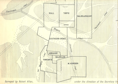
Surveyed by Robert Allan under the direction of the Secretary of Mines.Rectangular plan showing placement of mines in 1889. Mines include Hick's and Gilpin's lease, Comstock, Melbourne Company, Victoria United, Speedwell Company, New Normanby, Pasha Surprise, Central Sulieman, West Llanberris, Britannia United, Victoria Unites, Clinton's, Orient Company, North Sulieman, Sulieman Extended, Pasha Surprise, Golden Fountain, Prince regent, Clark and Company, Tinworth, North Woah Hawp, Detering, R.A. Thompson, Dazelles and buchanan, Barnett, Braybrook, Ladt Cornwall, Hanthorne, Dalzelles and gay, Southern Cross, M. Acheson, Cricket Reserveballarat east, mines, mining, underground survey, robert allan, chinese, ah chong, ah young, bakery hill, black hill, black hill lead, bakery hill lead, cricket, pennyweight hill, gravel pitts lead, golden point lead, navy jack's lead, mopoke lead, eureka lead, association lead, warrenheip lead, cgt, plans -
 Flagstaff Hill Maritime Museum and Village
Handle, c. 1859
This brass handle was found on Sea Elephant Bay beach in King Island, Tasmania, in 1913. The donor identified it as being from the wreck of the Newfield. It would could have been part of the fittings or amongst the cargo on the ship. ABOUT THE "NEWFIELD" The Newfield was a three-masted iron and steel barque, built in Dundee, Scotland, in 1889 by Alexander Stephen and Sons. It was owned by the Newfield Ship Company in 1890 and later that year It was registered in Liverpool to owners Brownells and Co. The Newfield left Sharpness, Scotland, on 28th May 1892 with a crew of 25 under the command of Captain George Scott and on 1st June left Liverpool. She was bound for Brisbane, Australia, with a cargo of 1850 tons of fine rock salt, the main export product of Sharpness. At about 9pm on 28th August 1892, in heavy weather, Captain Scott sighted, between heavy squalls, the Cape Otway light on the mainland of Victoria but, due to a navigational error (the ship’s chronometers were wrong), he assumed it to be the Cape Wickham light on King Island, some 40 miles south. He altered his course to the north, expecting to enter Bass Strait. The ship was now heading straight for the south west Victorian coast and at about 1:30am ran aground on a reef about 100 yards from shore and one mile east of Curdie’s Inlet, Peterborough. The ship struck heavily three times before grounding on an inner shoal with 6 feet of water in the holds. Rough sea made the job of launching lifeboats very difficult. The first two lifeboats launched by the crew were smashed against the side of the ship and some men were crushed or swept away. The third lifeboat brought eight men to shore. It capsized when the crew tried to return it to the ship for further rescue The Port Campbell rocket crew arrived and fired four rocket lines, none of which connected with the ship. A local man, Peter Carmody, volunteered to swim one mile to the ship with a line to guide the fourth and final lifeboat safely to shore. Seventeen men survived the shipwreck but the captain and eight of his crew perished. One of the men, apprentice William McLeod, was rescued by local woman Margaret E. MacKenzie. The Newfield remained upright on the reef with sails set for a considerable time as the wind slowly ripped the canvas to shreds and the sea battered the hull to pieces. The Marine Board inquiry found the wreck was caused by a "one man style of navigation" and that the Captain had not heeded the advice of his crew. According to Jack Loney ‘… when the drama was over . . the Newfield was deserted except for the Captain’s dog and two pigs.’ Flagstaff Hill Maritime Museum has several artefacts that have been salvaged from the wreck. A report from SHP documented the following in regards to the Newfield collection: Flagstaff Hill’s collection of artefacts from the Newfield is of historical and archaeological significance at a State level, because of its association with the shipwreck, which is on the Victorian Heritage Register. The collection is significant because of its relationship between the objects. The Newfield collection is archaeologically significant as it is the remains of an international cargo ship. The Newfield collection is historically significant for representing aspects of Victoria’s shipping history and its potential to interpret sub-theme 1.5 (Living with natural processes). The collection is also historically significant for its association with the shipwreck. The Newfield collection meets the following criteria for assessment: Criteria A: Importance to the course, or pattern, of Victoria’s cultural history Criteria B: Possession of uncommon, rare or endangered aspects of Victoria’s cultural history Criteria C: Potential to yield information that will contribute to an understanding of Victoria’s cultural history Ornate brass handle, round plates each end, each with 4 round fixing holes. Found washed up on Sea Elephant Bay beach, King Island 1913, identified by donor as being from the wreck of the Newfield.flagstaff hill, warrnambool, shipwrecked-coast, flagstaff-hill, flagstaff-hill-maritime-museum, maritime-museum, barque newfield, shipwreck-coast, flagstaff-hill-maritime-village, ornate handle, sailing ship fitting, sea elephant bay, king island -
 Flagstaff Hill Maritime Museum and Village
Photograph, post 1889
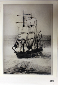
The photograph shows the three-masted iron and steel bark "Newfield" sailing in open seas. It event would have been between 1889-1892 during the ship's working life. ABOUT THE NEWFIELD The Newfield was a three-masted iron and steel barque, built in Dundee, Scotland, in 1889 by Alexander Stephen and Sons. It was owned by the Newfield Ship Company in 1890 and later that year It was registered in Liverpool to owners Brownells and Co. The Newfield left Sharpness, Scotland, on 28th May 1892 with a crew of 25 under the command of Captain George Scott and on 1st June left Liverpool. She was bound for Brisbane, Australia, with a cargo of 1850 tons of fine rock salt, the main export product of Sharpness. At about 9pm on 28th August 1892, in heavy weather, Captain Scott sighted, between heavy squalls, the Cape Otway light on the mainland of Victoria but, due to a navigational error (the ship’s chronometers were wrong), he assumed it to be the Cape Wickham light on King Island, some 40 miles south. He altered his course to the north, expecting to enter Bass Strait. The ship was now heading straight for the south west Victorian coast and at about 1:30am ran aground on a reef about 100 yards from shore and one mile east of Curdie’s Inlet, Peterborough. The ship struck heavily three times before grounding on an inner shoal with 6 feet of water in the holds. Rough sea made the job of launching lifeboats very difficult. The first two lifeboats launched by the crew were smashed against the side of the ship and some men were crushed or swept away. The third lifeboat brought eight men to shore. It capsized when the crew tried to return it to the ship for further rescue The Port Campbell rocket crew arrived and fired four rocket lines, none of which connected with the ship. A local man, Peter Carmody, volunteered to swim one mile to the ship with a line to guide the fourth and final lifeboat safely to shore. Seventeen men survived the shipwreck but the captain and eight of his crew perished. One of the men, apprentice William McLeod, was rescued by local woman Margaret E. MacKenzie. The Newfield remained upright on the reef with sails set for a considerable time as the wind slowly ripped the canvas to shreds and the sea battered the hull to pieces. The Marine Board inquiry found the wreck was caused by a "one man style of navigation" and that the Captain had not heeded the advice of his crew. According to Jack Loney ‘… when the drama was over . . the Newfield was deserted except for the Captain’s dog and two pigs.’ Flagstaff Hill Maritime Museum has several artefacts that have been salvaged from the wreck. The report from SHP documented the following in regards to the Newfield collection: Flagstaff Hill’s collection of artefacts from the Newfield is of historical and archaeological significance at a State level, because of its association with the shipwreck, which is on the Victorian Heritage Register. The collection is significant because of its relationship between the objects. The Newfield collection is archaeologically significant as it is the remains of an international cargo ship. The Newfield collection is historically significant for representing aspects of Victoria’s shipping history and its potential to interpret sub-theme 1.5 (Living with natural processes). The collection is also historically significant for its association with the shipwreck. Black and white photograph of the three-masted sailing ship “Newfield” in the open sea, sails unfurled. The ship was built in 1859 by Alexander Stephen and Sons Limited of Dundee, Scotland. flagstaff hill, warrnambool, shipwrecked-coast, flagstaff-hill, flagstaff-hill-maritime-museum, maritime-museum, shipwreck-coast, flagstaff-hill-maritime-village, barque newfield, photograph, 1880s sailing ship -
 Flagstaff Hill Maritime Museum and Village
Photograph - Ship Crew, 1889-1892
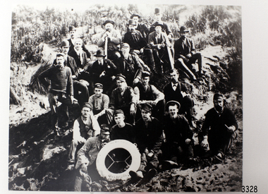
This black and white photograph shows the crew of the barque Newfield. They are pictured seated on a grassy slope and rock, a lifebuoy from the Newfield, Liverpool, resting on the men in the front row. The men are formally dressed, some with bowler hats, a bow tie and pipe, rather than in their sailing uniforms. ABOUT THE NEWFIELD The Newfield left Sharpness, Scotland, on 28th May 1892 with a crew of 25 under the command of Captain George Scott and on 1st June left Liverpool. She was bound for Brisbane, Australia, with a cargo of 1850 tons of fine rock salt, the main export product of Sharpness. At about 9pm on 28th August 1892, in heavy weather, Captain Scott sighted, between heavy squalls, the Cape Otway light on the mainland of Victoria but, due to a navigational error (the ship’s chronometers were wrong), he assumed it to be the Cape Wickham light on King Island, some 40 miles south. He altered his course to the north, expecting to enter Bass Strait. The ship was now heading straight for the south west Victorian coast. At about 1:30am the Newfield ran aground on a reef about 100 yards from shore and one mile east of Curdie’s Inlet, Peterborough. The ship struck heavily three times before grounding on an inner shoal with 6 feet of water in the holds. Rough sea made the job of launching lifeboats very difficult. The first two lifeboats launched by the crew were smashed against the side of the ship and some men were crushed or swept away. The third lifeboat brought eight men to shore. It capsized when the crew tried to return it to the ship for further rescue The rescue was a difficult operation. The Port Campbell Rocket Crew arrived and fired four rocket lines, none of which connected with the ship. Peter Carmody, a local man, volunteered to swim about one mile off shore to the ship with a line to guide the fourth and final lifeboat safely to shore. He was assisted by James McKenzie and Gerard Irvine. Seventeen men survived the shipwreck but the captain and eight of his crew perished. The Newfield remained upright on the reef with sails set for a considerable time as the wind slowly ripped the canvas to shreds and the sea battered the hull to pieces. The Marine Board inquiry found the wreck was caused by a "one man style of navigation" and that the Captain had not heeded the advice of his crew. According to Jack Loney ‘… when the drama was over . . the Newfield was deserted except for the Captain’s dog and two pigs.’ Peter Carmody was awarded the Bramley Moore medal by the Liverpool Shipwreck and Humane Society for Saving Life at Ssea, which he received by mail on January 21st 1893. Flagstaff Hill’s collection of artefacts from the Newfield is significant for its association with the shipwreck Newfield, which is listed on the Victorian Heritage Registry. The collection is significant because of the relationship between the objects. The Newfield collection is archaeologically significant as the remains of an international cargo ship. The Newfield collection is historically significant for representing aspects of Victoria’s shipping history and its association with the shipwreck. The Letter accompanying the Medal for Bravery awarded to Peter Carmody is significant because the attempt to save lives is associated with the shipwreck Newfield. Black and white photograph of the crew of the sailing ship “Newfield”. The men in formal dress are seated on rocky slope with the ship’s lifebuoy showing the name “NEWFIELD, LIVERPOOL”. Photograph taken 1889-1892 flagstaff hill, warrnambool, shipwrecked-coast, flagstaff-hill, flagstaff-hill-maritime-museum, maritime-museum, shipwreck-coast, flagstaff-hill-maritime-village, newfield, photograph, crew of the newfield, 19th century sailing ship, peterborough, cape otway, medal for bravery -
 Federation University Historical Collection
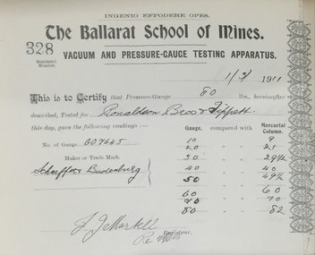
Book, Ballarat School of Mines Vacuum and Pressure-gauge Testing Apparatus Certificate Book, 1902-1932, 1902-1932
The Ballarat School of Mines was the first School of Mines in Australiasia, and had a model mining laboratory which provided testing for a fee.Quarter leather bound book with an alphabetical listing of names, and certificates and stubbs for Ballarat School of Mines Vacuum and Pressure-gauge Testing Apparatus Certificates.ballarat school of mines, vacuum and pressure-gauge testing apparatus certificate book, certicates, stubbs, vacuum testing, pressure gauge testing, m.b. john, berry united gold mining company, birthday company, britannia united gold mining company, cambrain company, dry diggings gold mining company, dimboola flour mill, first chance gold mining company, great northern extended consols rutherglen, h.v. mckay, lady brassey company, llanberris no. 1, llanberris no 2, mcvitty and company, phoenix foundry, e. rowlands, south woah hawp, tinworth and party, victoria corish united, william's fancy company, woah hawp canton gold mining company, woah hawp no. 2, andrew andreson, bourdons, frederick martell, lonie and dingle, cornish gold mines daylesford, j.d. williams, jane brad, clunes, wendouree asylum, electric hydralic dredging party, east jubilee gold mining company, j.e. cowley, john mann, normanby north company, new imperial gold mining company, ballarat brewing company, yarrowee dredging company, a. mckirdy, daylesford, pearce brothers, canadian, hepburn mineral spring company, \e. balhausen, ronaldson borthers and tippett, ballarat woollen mills, cathacart central gold mining company, j.b. robinson -
 Federation University Historical Collection
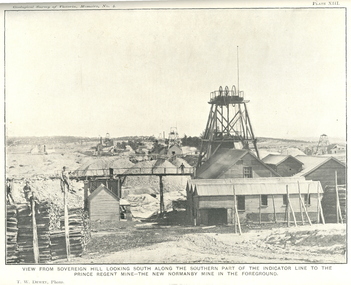
Book, J.W. Gregory, Memoirs of the Geological Survey of Victoria No. 4: The Ballarat East Gold-Field, 1907, 1907
Blue soft covered report with 40 plates and plans. Inciudes Geology of Ballarat. Little Bendigo Goldfield, Ballarat West Goldfield, Ballarat East Goldfield, history, nuggets, indicators, faults, microscopic structure of Ballarat Rocks and ores, general type of the Ballarat East Mines and the genesis of their ores. Mines include New Zealand Trust, Llanberris No. 1, Llanberris No 2, Victoria United, Britannia United, New Britannia, Last Chance, Exchange, Normanby North, New Normanby, North Woah Hawp. Photpgraphic plates include: Victoria United Mine, Llanberres No. 1, Normanby North, North Woah Hawp Mine, View looking south from the Britannia Mullock Heap, View from Sovereign Hill, The place in Learmonth Street Golden Point where gold was first discovered at Ballarat. j.w. gregory, ballarat east, ballarat east goldfield, e.j. dunn, geolological survey of victoria, new zealand trust, llanberris no. 1, llanberris no 2, victoria united, britannia united, new britannia, last chance, exchange, normanby north, new normanby, north woah hawp, mining, indicators, gold mining, poppet head -
 Ringwood and District Historical Society
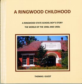
Book, Thomas Guest, A Ringwood Childhood, 2022
Sub-titled A Ringwood State School Boy's Story - The World Of The 1940s And 1950s by Thomas J Guest. Hard cover book with photographs, poetry and stories recalling the author's family life growing up in East Ringwood, Victoria. -
 Ringwood and District Historical Society
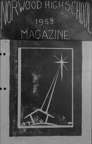
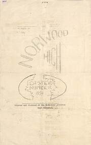
Booklet, Norwood High School 1958 Magazine
Typewritten magazine - 1958 - first year of Norwood High School, Ringwood, Victoria.non-fiction -
 Ringwood and District Historical Society
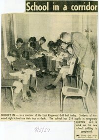
Newspaper - Clippings, Melbourne Herald 8th May, 1959 - Norwood High School, Ringwood, Victoria
Norwood High School started the school year in multiple temporary premises while the new school was being erected in Byron Street, eventually opening mid 1959.Temporary alternative classroom accommodation report with photographs.Altogether, 214 pupils of the school work in what teachers say are impossible conditions in the East Ringwood drill hall, the Anglican Church Hall, and (East Ringwood) football pavilion. -
 Ringwood and District Historical Society
Newspaper, Easter Newsletter 1959 - Norwood High School, Ringwood, Victoria
Double sided photocopy of 2-page typewritten foolscap pages.Printed and produced at the temporary premises, East Ringwood. -
 Ringwood and District Historical Society
Newspaper, Scrapbook Clipping, Library Collection, Ringwood, Victoria
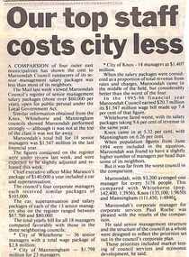
Newspaper Clipping from The Mail, 9-7-96, P7 - Our top staff costs city lessA comparison of four outer east municipalities has shown the cost to Maroondah Council ratepayers of its senior management salary packages was less than most of its neighbours. -
 Ringwood and District Historical Society
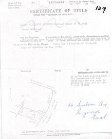
Document, Partial copy of Certificate of Title Vol 7635 Fol 096 Lot 29, 44 Sunbeam Avenue Ringwood East, Victoria
Black and white photocopied page with added notations in blue pen.Ellen Elizabeth Stanton, Married Woman of 35 Bell Street Richmond is now the Proprietor of an estate in Fee-simple, subject to the Encumbrances notified herunder in the surface down to the depth of fifty feet below the surface of the pie of land delineated and colored red purple and blue on the map in the margin, being Lot 29 Parish of Ringwood. Plan of Subdivision No. 12150. (undated). -
 Ringwood and District Historical Society
Newspaper, Scrapbook Clipping, Library Collection, Ringwood, Victoria
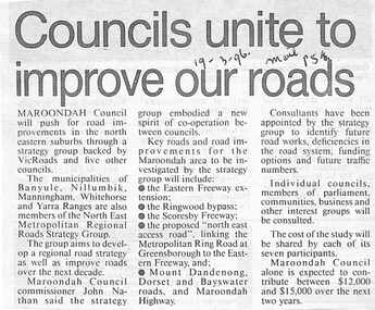
Newspaper Clipping from The Mail, 19-3-96, P 5. Councils unite to improve our roads.Maroondah Councilwill push for road improvements in the north eastern suburbs through a strategy group backed by Vicroads and five other councils. The municipalities of Banyule, Nillumbik, Manningham, Whitehorse and Yarra Ranges are also members of North East Metropolitan Regional Roads Strategy Group. -
 Ringwood and District Historical Society
Newspaper, Scrapbook Clipping, Library Collection, Ringwood, Victoria, `
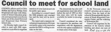
``Newspaper clipping from The Post , 24-11-93 P3 Council to meet for school landCouncil officers and Crs Chris McRae and Sylvia Phillips from Ringwood will meetwith the Direcvtorate of School Education property unit representatives to discuss future useof the closed Norwood and Ringwoo East School sites. The DSE property unit manager has said the sites will be developed.` -
 Ringwood and District Historical Society
Certificate, United Grand Lodge of Victoria Membership - Collection of Masonic Degrees and Correspondence maintained by Aird family of Ringwood, Victoria
Certification that Brother Samuel Williams was regularly received into the Free Masonry on 5th December AL5950 and was admitted to the 3rd Degree on 5th June, 1951, in the East Burwood Lodge No. 686. Certificate signed and blue seal attached on 17th January, 1952. -
 Ringwood and District Historical Society
Newspaper, Scrapbook Clipping, Library Collection, Ringwood, Victoria, `
``Newspaper clipping from the "Post", 10-2-98.The Maroondah community will lead the outer east with the development of a Public Internet Training and Access Centre. As part of the Multimedia Victoria funding allocation, a Learning Information Network and Community Service (LINCS) centre will be set-up at Eastland Shopping Centre in Ringwood. ` -
 Ringwood and District Historical Society
Newspaper, Scrapbook Clipping, Library Collection, Ringwood, Victoria, `
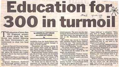
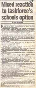
``Newspaper clipping from the "Mail" 19-10-93 P1. Education for 300 in turmoil, by Leonara Elliot-Bruce and Jodie Haythorne The education of more than 300 Ringwood Primary School pupils has been thrown into turmoil following the State Government's announcement to close two local schools.Ringwood East and Norwood primary schools were told last Friday they would close at the end of the year. The principals are not happy. ` -
 Ringwood and District Historical Society
Newspaper, Scrapbook Clipping, Library Collection, Ringwood, Victoria, `
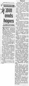
``Newspaper clipping from "The Mail" October 26, 1993. School bill ends hopes. By Jodie HaythorneSweeping education reforms introduced to State Parliament last week could stop Ringwood East Primary School from fighting closure.` -
 Ringwood and District Historical Society
Newspaper, Scrapbook Clipping, Library Collection, Ringwood, Victoria, `
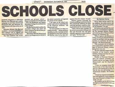
``Newspaper clipping from "The Post" Wednesday, October 20, 1993, by Damian Kemp Despite delegations to Education Minister Don Hayward and a public campaign to save their schools, both Ringwood East and Norwood Primary Schools will close at the end of 1993. Education Minister Don Hayward modified a recommendation from a third taskforce, and no schools will close in the Ringwood schools cluster.` -
 Ringwood and District Historical Society
Newspaper, Scrapbook Clipping, Library Collection, Ringwood, Victoria, `
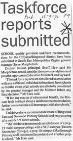
``Newspaper clipping from "The Post", 15-9-93, P9 School quality provision taskforce recommendations for the Croydon/Ringwood district have been submitted to South East Metropolitan General Manager Steve Macpherson. District Liaison proncipal Geoff Haw said Mr Macpherson would consider the recommendations and pass the reports onto Education Minister Don Hayward.` -
 Ringwood and District Historical Society
Newspaper, Scrapbook Clipping, Library Collection, Ringwood, Victoria, `
``Newspaper clipping from "The Mail", 15-9-93, P9 by Jodie Haythorn Ringwood East and Norwood primary schools will close at the end of the year if recommendations by quality provision taskforces are implemented.And Marlborough Primary Schoolis set to merge with Heathmont Secondary to form a year prep to 10 campusand a VCE campus at Eastern Secondary College as part of a multi campus disrict facility.` -
 Ringwood and District Historical Society
Newspaper, Scrapbook Clipping, Library Collection, Ringwood, Victoria, `
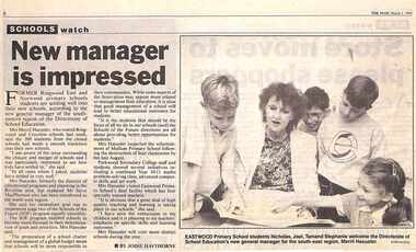
``Newspaper clipping from "The Mail", 1-03-1994 P1. SCHOOLS watch. New Manager is impressed. By Jodie Hawthorne Former Ringwood East and Norwood primary school students are settling well into their new schools, according to the new general manager of the south eastern region of the Directorate of School Education. Mrs Merril Haeusler, who toured Ringwood and Croydon last week, said the 300 students from the closed schools had made a smooth transition into their new schools.` -
 Ringwood and District Historical Society
Newspaper, Scrapbook Clipping, Library Collection, Ringwood, Victoria, `
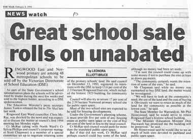
``Newspaper clipping from "The Mail", 8-02-1994 P3. NEWS watch. Great school sale rolls on unabated. By LEONORA ELLIOT-BRUCE Ringwood East and Norwood primary are among 48 metropolitan schools to be sold off by the Victorian Directorate of School Education (DSE). The schools will be advertised by tender during the next few weeks and sold to the highest bidder, according to a DSE spokeswoman. Ringwood East Ward councillor, Chris McCrae, was shocked by the news, and was expected to discuss the matter at council's first 1994 meeting last Monday night.` -
 Ringwood and District Historical Society
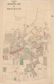
Map, Borough of Ringwood, Victoria - c.1950s
A0-size (approx) map of named streets and lot-numbered properties within Borough of Ringwood ward boundaries. Colour-coded key marking Land Under Control of Council, Factory Areas, and Business Areas.Scale: 8 chains to 1 inch. North Ward, East Ward, South Ward. -
 Ringwood and District Historical Society
Map - State Aerial Survey, Dandenong Ranges Area, Parishes of Warrandyte and Ringwood - 1956
Map of central and southern areas of Ringwood and part of Ringwood East and Heathmont compiled by Dept of Lands and Survey, July 1956, from aerial photographs and Cadastral Survey information. Subsequent hand-drawn addition of streets showing layout of "Township of Ballyduffy Estate 1858-60", an earlier proposed subdivision that did not eventuate. (See attached 5009b Ballyshanassy_ Melbourne’s lost suburb.pdf for Ballyduffy historical naming relevance). Ballyduffy Estate streets include City Road, West Prussia Road, Duffy Street, Ireland Street, Evans Street, Victoria Street, Regina Street, Short Road, Prussia Road, Duffy Street East, Ireland Street East, Evans Street East, Chapman Street. Misc Topo 93 Sheet 22, Ringwood A4B2. Scale: 4 chains to 1 inch. Contour interval 20 feet.