Showing 1786 items matching "settlement"
-
 Warrnambool and District Historical Society Inc.
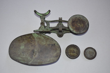
Scales, W. & T. Avery Ltd. Mill Lane Works, Nullawarre PO & tray + 2 weights, Early 20th century
These scales come from the Nullawarre Post Office and would have been used there for most of the 20th century. Nullawarre is a small settlement 25 kilometres south east of Warrnambool. It was first settled in the late 1860s and 70s and the main agricultural pursuit for the area today is dairying. The first Nullawarre school was opened in 1878 and the Nullawarre Post Office operates today in the Nullawarre General Store. These scales are of interest as a memento of the type of weighing scales used in Post Offices in Victoria in the early to mid 20th century. They are also of local interest as they come from the Nullawarre Post Office.This is a metal set of scales with a balance mechanism on a metal stand. The balance has a circular tray at one end to hold weights An oval dish to hold items to be weighed is a separate item that sits at the other end of the balance. The scales were once painted green and some traces of the green paint are visible. Two weights are with this item. The scales are much rusted. ‘W & T Avery Ltd Birm.’nullawarre, victoria, history of warrnambool -
 Eltham District Historical Society Inc
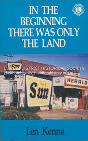
Book, Len Kenna, In the beginning there was only the land, 1988
A book, published as part of the Australian Bicentenary Celebrations on the history of the suburb of Bundoora. ... Includes photographs, maps and index. Local history of the outer Melbourne suburb of Bundoora, from the original Wurundjeri people through to its development as a thriving suburb in the 1980s ; section entitled "The Aborigines" (pp.14-21) discusses the traditional way of life of the Wurundjeri people prior to European settlement.bundoora, bundoora hall, hospitals, jane mckimmie, janefield, janefield church, john mckimmie, la trobe university, marvellous melbourne, mont park, mont park psychiatric hospital, plenty river, william shillinglaw, wurundjeri, yan yean reservoir -
 Wycheproof & District Historical Society Inc.
Bunguluke Map, Bunguluke District In 1923, 27.2.1923
By 1881 Bunguluke was a small settlement as recorded, December 5, in the Charlton "Mercury". It reports that in that year Draper's Store, Hotel and Post Office and residence at Bunguluke North was totally destroyed by fire. For years now there has been little sign of community life with houses few and far between and acreages have gone into larger holdings. The map references land blocks and owners for that era.This important map shows the local land ownership and local features that existed in 1923. This is a photocopied black and white map of Bunguluke in the County of Kara Kara, Number L5149. Marked - Photo Lithographed by W.J. Butson 27.2.1923. The details include numbers of allotments, property owners, roads, rivers. The boundaries marked are the Parish of Jeruk, Parish of Wycheproof, Parish of Cooroopajerrup. Wycheproof township location is shown with the Scale of Chains. Bunguluke maps for other years are also in the collection.map, bunguluke, jeruk, wycheproof, cooroopajerrup -
 Wycheproof & District Historical Society Inc.
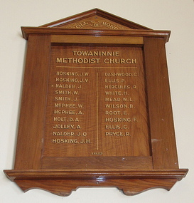
Framed photograph, Mrs Elaine Storey, Roll of Honour Towaninnie Methodist Church, 26/10/2008
The Towaninnie Methodist Church no longer exists but on the Towaninnie plains a location sign marks it. In common with many church communities the faithful who met here were very patriotic and their young men were strongly supported when they volunteeered during the Great War of 1914 -'18. This Honour Board once hung on the Methodist Church wall but is now at the Pioneer Settlement,Swan Hill.The actual Honour Board is believed to be the only one of its type with this listing. This photo of it contributes to and is part of a Local, State and National collection of War memorabilia that honours our servicemen and women.Wooden framed Roll of Honour photo - Towaninnie Methodist Church listing of 21 local WW1 servicemen. The memorial has a triangular shaped top and features a simple wooden sculpured bottom edging with the gold inscriptions in 2 columns. Hosking,J.W./ Hosking, J.V. / FALLEN Nalder, J./ Smith,W./ Smith, J./ McPhee,W./ McPhee, A./ Holt,D.A./ Jolley,A./ Nalder,J.Q./ Hosking,J.H./ Dashwood,C./ Ellis,P./ Hercules,R./ White,H. / Mead,W.L./ Wilson,B./ Root,E./ Hosking, F./ Ellis,C./ Pryse,R. Roll of Honour Towaninnie Methodist Church. Hosking,J.W./ Hosking, J.V. / FALLEN Nalder, J./ Smith,W./ Smith, J./ McPhee,W./ McPhee, A./ Holt,D.A./ Jolley,A./ Nalder,J.Q./ Hosking,J.H./ Dashwood,C./ Ellis,P./ Hercules,R./ White,H. / Mead,W.L./ Wilson,B./ Root,E./ Hosking, F./ Ellis,C./ Pryse,R. roll - of - honour, towaninnie - methodist, towaninnie - church, world - war 1, wycheproof - servicemen -
 Orbost & District Historical Society
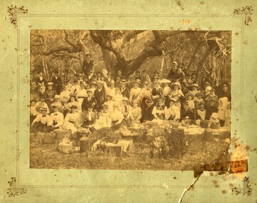
Photograph - Picnic at Old Station, Orbost
The Old Station Homestead site at Corringle Beach was a popular destination for Orbost people to have picnics late 19Century. They would travel out in buggies from Orbost or Newmerella with food hampers, have a picnic, play games etc. This location was always referred to as the Old Station because it had been one of the earliest Stations in this district in the early days of European settlement. evidence of recreation, entertainment in the Orbost districtA sepia coloured photograph pasted onto grey cardboard. Photo shows a group of people standing and sitting under trees with picnic baskets and hampers in the foreground. Many people wear hats. On back of photograph: Mrs Reynolds Senr, 72 Boundary Road. Old Station Beach, Orbost orbost, corringle, old station homestead site, picnic -
 Glen Eira Historical Society
Plan - LEMPRIERE AVENUE
One item about this location 1/Excerpts (5 pages) from Andrew Wards Heritage Study vol 2, 3.6 on Lempriere Avenue and ‘Greenmeadows Gardens’ Historic Area include street plan and general view of Roselle Estate’, Greenmeadows Garden. Included in his description is mention of a large eucalypt in ‘Greenmeadows Gardens’ which pre-dates European settlement.streetscape, lempriere avenue, ‘greenmeadows gardens’, meadow street, alston grove, californian bungalow style, fences, spanish mission style, ‘greenmeadows house, lempriere w. g., meadow street, clarke william senior, ‘greenmeadows’, trees, balaclava road, orrong road, allan road, meadow street, lempriere john, kirton mr, dickson and yorston (pty ltd), lempriere ruby l mrs, dickson g c, yorston j c, st kilda east, east st kilda, roselle estate, east st kilda, east st kilda riding -
 Bendigo Historical Society Inc.
Document - Martin's Family History, 9/11/23
Pompapiel is a small settlement between Dingee and Serpentine. Edward Martin (b. 1858)arrived in South Australia from Ireland in 1879. In 1882 they settled at Salisury West in Victoria. In 1909 he purchased the property "Lorraine" in Pompapiel. This property was sold and the family moved a mile away. 1911 they repurchased "Lorraine". and continued to farm. Edward died in 1940 and is buried at Inglewood cemetery.A document detailing the long history of the Martin family.martin family, family history -
 Mt Dandenong & District Historical Society Inc.
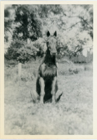
Photograph, Logan's Trick Horse
John Lundy-Clarke grew up in the Kalorama/Mt Dandenong area and later in life (1972-74) began to write a comprehensive history of the area working from an original settlement map in an effort to cover all areas. This photograph shows the 'trick horse' belonging to Robert Logan. Robert Logan settled on Lot 28 in 1896 and worked it until his death in 1936.Black and white photograph on a horse sitting in grass. Handwritten inscription on reverse by John Lundy-Clarke.1920 Logan’s trick horse on LOT 28 SECTION 1robert logan, logan, horse, kalorama, john lundy-clarke -
 Ballarat Tramway Museum
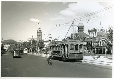
Photograph - Decorated tram Ballarat 23 in Sturt St, 1938
Photograph shows decorated tram No. 23, eastbound between Dawson and Doveton Streets. The tram was decorated for the 100 years of European settlement (1938) in the Ballarat district. The Queen Alexandra bandstand and buildings in the background have been decorated as well. The street decoration just in front of the tram, was recycled from an earlier Melbourne celebration event. A young man is riding a bicycle alongside the tram.Yields information about the decoration of Sturt St and tram 23 for the 100 years of European settlement (1938).Black and white print of decorated tram 23 in Sturt St, east bound passing the Queen Alexandra Bandstand.ballarat, sturt st, trams, tram 23, decorated trams, queen alexandra bandstand, celebrations. -
 Kew Historical Society Inc
Photograph - Flooding of the Yarra River in North Kew, 1934
North Kew, now divided between Kew and Kew East, bordered the Yarra River. As such, it was a region subject to flooding in the Yarra Valley. Development beyond this point (ie Kellett Grove) was limited by the City of Kew's planning regulations. Prior to urban development, the area since European settlement and the first land sales in the district in the 1840s, had been used for dairy farming. Small sepia snapshot taken from the river ramp of a house at 8 Kellett Grove, in what was then known as North Kew. The point of view is from a backyard looking towards Fairfield. Beyond the fence line are two almost submerged houses. A number of people are in a motor driven boat midstream. Fairfield at this period, (ie 1934) was noted for its limited river side development. Verso: 2/12/34 / TAKEN FROM OUR RAMPyarra river -- north kew, floods -- yarra valley, floods -- north kew, floods -- 1929, floods -- 1934, natural disasters -- kew -
 Kew Historical Society Inc
Photograph - 8 Kellett Grove, North Kew, 1929
North Kew, now divided between Kew and Kew East, bordered the Yarra River. As such, it was a region subject to flooding in the Yarra Valley. Development beyond this point (ie Kellett Grove) was limited by the City of Kew's planning regulations. Prior to urban development, the area since European settlement and the first land sales in the district in the 1840s, had been used for dairy farming. Small sepia snapshot taken of the front of 8 Kellett Grove, in what was then known as North Kew. Verso: 8 KELLETT GROVE / NORTH KEW / 1929 / 418 kellett gove -- north kew, californian bungalows, houses -- kellett grove -- kew (vic.) -
 Kew Historical Society Inc
Photograph - Flooding of the Yarra River in North Kew, 1934
North Kew, now divided between Kew and Kew East, bordered the Yarra River. As such, it was a region subject to flooding in the Yarra Valley. Development beyond this point (ie Kellett Grove) was limited by the City of Kew's planning regulations. Prior to urban development, the area since European settlement and the first land sales in the district in the 1840s, had been used for dairy farming. Small sepia snapshot taken from the back yard of a house at 8 Kellett Grove, in what was then known as North Kew. The point of view is from a backyard looking towards Fairfield. Floodwaters have submerged the fence and a clothes line. Verso: BACKYARD NTH. KEWyarra river -- north kew, floods -- yarra valley, floods -- north kew, floods -- 1934, natural disasters -- kew -
 Kew Historical Society Inc
Photograph - Flooding of the Yarra River in North Kew, 1934
North Kew, now divided between Kew and Kew East, bordered the Yarra River. As such, it was a region subject to flooding in the Yarra Valley. Development beyond this point (ie Kellett Grove) was limited by the City of Kew's planning regulations. Prior to urban development, the area since European settlement and the first land sales in the district in the 1840s, had been used for dairy farming. Small sepia snapshot taken from the back yard of a house at 8 Kellett Grove, in what was then known as North Kew. The point of view is from a backyard looking towards Fairfield. Verso: 8 KELLETT GROVEyarra river -- north kew, floods -- yarra valley, floods -- north kew, floods -- 1934, natural disasters -- kew -
 Kew Historical Society Inc
Photograph - Flooding of the Yarra River in North Kew, 1934
North Kew, now divided between Kew and Kew East, bordered the Yarra River. As such, it was a region subject to flooding in the Yarra Valley. Development beyond this point (ie Kellett Grove) was limited by the City of Kew's planning regulations. Prior to urban development, the area since European settlement and the first land sales in the district in the 1840s, had been used for dairy farming. Small sepia snapshot taken from the back yard of a house at 8 Kellett Grove, in what was then known as North Kew. The point of view is from a backyard looking towards Fairfield. Verso: OUR BACKYARD 8 KELLETT GROVEyarra river -- north kew, floods -- yarra valley, floods -- north kew, floods -- 1934, natural disasters -- kew -
 Kew Historical Society Inc
Photograph - View of the Yarra River from 8 Kellett Grove, North Kew, 1948
North Kew, now divided between Kew and Kew East, bordered the Yarra River. As such, it was a region subject to flooding in the Yarra Valley. Development beyond this point (ie Kellett Grove) was limited by the City of Kew's planning regulations. Prior to urban development, the area since European settlement and the first land sales in the district in the 1840s, had been used for dairy farming. The view from the rear of 8 Kellett Grove predates the construction of the Eastern Freeway so provides a rare view of the area before it was built.Small sepia snapshot taken from the back yard of a house at 8 Kellett Grove, in what was then known as North Kew. A tower of the Kew Asylum on the top left of the horizon assist the viewer to recognise that the land to the left of the river is in Kew and Studley Park.Verso: NORTH KEW 1948 / Stamped 51019yarra river -- north kew, kellett grove -- north kew -
 Kew Historical Society Inc
Photograph - Flooding of the Yarra River in North Kew, 1934
North Kew, now divided between Kew and Kew East, bordered the Yarra River. As such, it was a region subject to flooding in the Yarra Valley. Development beyond this point (ie Kellett Grove) was limited by the City of Kew's planning regulations. Prior to urban development, the area since European settlement and the first land sales in the district in the 1840s, had been used for dairy farming. Small sepia snapshot of floodwaters taken from near Kellett Grove, in what was then known as North Kew. The point of view is from a backyard looking towards Fairfield. In the foreground ar two men in a rowboat.Verso: OUR BACKYARD / Stamped 3 163yarra river -- north kew, floods -- yarra valley, floods -- north kew, floods -- 1934, natural disasters -- kew -
 Kew Historical Society Inc
Photograph - Flooding of the Yarra River in North Kew, 1934
North Kew, now divided between Kew and Kew East, bordered the Yarra River. As such, it was a region subject to flooding in the Yarra Valley. Development beyond this point (ie Kellett Grove) was limited by the City of Kew's planning regulations. Prior to urban development, the area since European settlement and the first land sales in the district in the 1840s, had been used for dairy farming. Small sepia snapshot of floodwaters taken from near Willsmere Road, in what was then known as North Kew. The point of view is looking towards Fairfield. In the foreground are two figures viewing a group in a rowboat in the middle of the flooded river. Semi-submerged street lighting indicates that entire streets had been. overwhelmed by the flood waters. Verso: WILLSMERE ROAD NORTH KEW / Stamped 3 163yarra river -- north kew, floods -- yarra valley, floods -- north kew, floods -- 1934, natural disasters -- kew, willsmere road -
 Kew Historical Society Inc
Photograph - Flooding of the Yarra River in North Kew, 1934
North Kew, now divided between Kew and Kew East, bordered the Yarra River. As such, it was a region subject to flooding in the Yarra Valley. Development beyond this point (ie Kellett Grove) was limited by the City of Kew's planning regulations. Prior to urban development, the area since European settlement and the first land sales in the district in the 1840s, had been used for dairy farming. Small sepia snapshot of floodwaters in North Kew. The point of view is of two houses belonging to local families that were surrounded by floodwater. Verso: HYATTS HOUSE / WILLSMERE ROAD / Stamped 3 163yarra river -- north kew, floods -- yarra valley, floods -- north kew, floods -- 1934, natural disasters -- kew, willsmere road -
 Kew Historical Society Inc
Photograph - Flooding of the Yarra River in North Kew, 1934
North Kew, now divided between Kew and Kew East, bordered the Yarra River. As such, it was a region subject to flooding in the Yarra Valley. Development beyond this point (ie Kellett Grove) was limited by the City of Kew's planning regulations. Prior to urban development, the area since European settlement and the first land sales in the district in the 1840s, had been used for dairy farming. Small sepia snapshot of floodwaters in North Kew, from the rear of 8 Kellett Grove. Verso: OUR BACKYARD / Stamped 52yarra river -- north kew, floods -- yarra valley, floods -- north kew, floods -- 1934, natural disasters -- kew, willsmere road -
 Kew Historical Society Inc
Photograph - Grandfather and granddaughter in the yard of 8 Kellett Grove, Kew, 1934
North Kew, now divided between Kew and Kew East, bordered the Yarra River. As such, it was a region subject to flooding in the Yarra Valley. Development beyond this point (ie Kellett Grove) was limited by the City of Kew's planning regulations. Prior to urban development, the area since European settlement and the first land sales in the district in the 1840s, had been used for dairy farming. Vivid photograph contrasting domestic life and relationships with natural disasters such as the flood of 1934.Small sepia snapshot of a grandfather and granddaughter sitting in the backyard of 8 Kellett Grove, North Kew, with the floodwaters stretching behind them.Verso: GRANDDAD AND I IN BACKYARDyarra river -- north kew, floods -- yarra valley, floods -- north kew, floods -- 1934, natural disasters -- kew, willsmere road -
 Kew Historical Society Inc
Photograph - Submerged houses in River Avenue, North Kew, 1934
North Kew, now divided between Kew and Kew East, bordered the Yarra River. As such, it was a region subject to flooding in the Yarra Valley. Development beyond this point (ie Kellett Grove) was limited by the City of Kew's planning regulations. Prior to urban development, the area since European settlement and the first land sales in the district in the 1840s, had been used for dairy farming. Vivid photograph contrasting domestic life and relationships with natural disasters such as the flood of 1934.Small sepia snapshot of two submerged houses belonging to local families in River Avenue, North Kew, during the 1934 floods. The view is presumably from near Kellett Grove looking north towards Fairfield.Verso: COES & HYATTS ROOF / RIVER AVENUE / Stamped: 6414yarra river -- north kew, floods -- yarra valley, floods -- north kew, floods -- 1934, natural disasters -- kew -
 Kew Historical Society Inc
Photograph - Flooding of the Yarra River in North Kew, 1934
North Kew, now divided between Kew and Kew East, bordered the Yarra River. As such, it was a region subject to flooding in the Yarra Valley. Development beyond this point (ie Kellett Grove) was limited by the City of Kew's planning regulations. Prior to urban development, the area since European settlement and the first land sales in the district in the 1840s, had been used for dairy farming. Vivid photograph contrasting domestic life and relationships with natural disasters such as the flood of 1934.Small sepia snapshot of the donors grandfather rescuing the family dog's kennel from rising floodwaters at the rear of 8 Kellett Grove, North Kew, .Verso: DAD SECURING NIPPY'S DOG KENNEL / Stamped 6414yarra river -- north kew, floods -- yarra valley, floods -- north kew, floods -- 1934, natural disasters -- kew -
 Kew Historical Society Inc
Photograph - Flooding of the Yarra River in North Kew, 1934
North Kew, now divided between Kew and Kew East, bordered the Yarra River. As such, it was a region subject to flooding in the Yarra Valley. Development beyond this point (ie Kellett Grove) was limited by the City of Kew's planning regulations. Prior to urban development, the area since European settlement and the first land sales in the district in the 1840s, had been used for dairy farming. .Small sepia snapshot of a local family's house in what was then River Avenue, North Kew being surrounded by floodwaters.Verso: THE SIDE OF RYANSyarra river -- north kew, floods -- yarra valley, floods -- north kew, floods -- 1934, natural disasters -- kew -
 Kew Historical Society Inc
Photograph - Flooding of the Yarra River in North Kew, 1934
North Kew, now divided between Kew and Kew East, bordered the Yarra River. As such, it was a region subject to flooding in the Yarra Valley. Development beyond this point (ie Kellett Grove) was limited by the City of Kew's planning regulations. Prior to urban development, the area since European settlement and the first land sales in the district in the 1840s, had been used for dairy farming. .Small sepia snapshot of what was then River Avenue, North Kew submerged by floodwaters.The photo was taken in the vicinity of 8 Kellett Grove, North Kew. Verso: TAKEN FROM OUR STREET JUST SEE A BIT OF RYAN'S FENCE / 1934yarra river -- north kew, floods -- yarra valley, floods -- north kew, floods -- 1934, natural disasters -- kew -
 Kew Historical Society Inc
Photograph - Flooding of the Yarra River in North Kew, 1934
North Kew, now divided between Kew and Kew East, bordered the Yarra River. As such, it was a region subject to flooding in the Yarra Valley. Development beyond this point (ie Kellett Grove) was limited by the City of Kew's planning regulations. Prior to urban development, the area since European settlement and the first land sales in the district in the 1840s, had been used for dairy farming. .Small sepia snapshot of the devastation caused by the 1934 flood.The photo was taken in the vicinity of Kellett Grove, North Kew and includes the roof of Chipperfield's Boathouse as well as other local houses.Verso: THIS IS CHIPPERFIELD'S BOAT SHEDS & COES & WILLIAMS TAKEN FROM OUR STREET / 1934yarra river -- north kew, floods -- yarra valley, floods -- north kew, floods -- 1934, natural disasters -- kew, chipperfields boathouse -
 Federation University Historical Collection
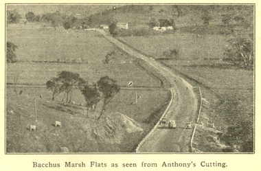
Booklet, F.C. Mc C. Crisp, Bacchus Marsh Centenary Celebrations, 10/1936
Bacchus Marsh celebrated 100 years of white settlement in 1936. The centenary celebrations committee comprised of L.M. Dugdale (President), A.W. Bond (Hon. Secretary), Charles Dickie, W. Grant Morton, W.R. Vigor, C.J. McFarlane, G.H. Anderson, T.J. Shea, F.C. McC Crisp, Dr E. McDonald, Robert Elliott (treasurer), R.H. Lambert (Decorations manager)Brown covered book of 28 pages. The book includes an historical essay, official centenary programme, Electric Light Plant, Patriotic Bacchus Marsh, milk industry, Pioneer Women's Memorial Avenue, Bacchus Marsh Gas Works . The book includes numerous advertisement, some illustrated. Images include: * Bacchus Marsh Flats from Anthony's Cutting; * Manor house; * Scene in Maddingley Park * Werribee Valley; * Werribee Gorge * Maddingley Park lake; * ANA Hall and Post Office * Shire Hall and Soldiers' Memorial Hall, * State School No 28 * At Werribee Gorge ** The Gas Supply Co, Bacchus Marsh * Bacchus Marsh Shire Council, 1935-6 (named) Images depicted in the book were supplied by H.J.M. Vallancebacchus marsh, merrimu guest house, anthony's cutting, captain bacchus, manor house, maddingley, maddingley park, werribee gorge, bacchus marsh shire, bacchus marsh shire council -
 Warrnambool and District Historical Society Inc.
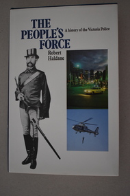
Book, Melbourne University Press, The people's force, 1986
A history of the Victorian Police Force up to the late 20th century..1 This is a hard cover book of 372 pages with a blue cover and silver printing on the spine. The dust cover has a white and blue background with a photograph of a 19th century policeman, six colour photographs and one black and white photograph. The printing on the dust cover is in white, blue and black. The book contains six chapters and many sketches, illustrations, photographs and graphs. .2 This is a 1986 newspaper cutting from the Warrnambool Standard featuring an article on the book, The People’s Force. A history of the Victorian Police Force up to the late 20th century.victorian police force, warrnambool -
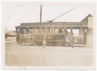 Ballarat Tramway Museum
Photograph - Digital image, 12/03/1938 12:00:00 AM
Yields information about Ballarat 's 23, then 69, ex Adelaide when decorated for the 1938 state celebrations.Digital image from the Wal Jack Ballarat Album of a tram No. 23 or Adelaide 69, decorated with waxed flowers for the centenary of settlement in the Ballarat district in 1938, floral tram at Redan. Has a number of people looking at the tramcar and a crew member standing on the rear step. Dated in Wal's album notes as 12-3-38, which could be indicative that he took the photograph. See image i2 for rear of photograph. Hi Res scan of the original negative added 13/1/2019 - see image btm5186i3.jpgtrams, tramways, floral tram, decorated trams, centenary, tram 69, tram 23 -
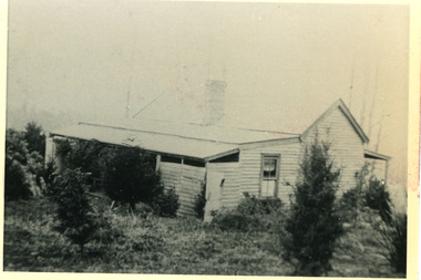 Mt Dandenong & District Historical Society Inc.
Photograph, c1911
"Hillcrest" on Mernda Road, Olinda. The home of the Devine Family. c1911 The descriptive text on the reverse of this photograph was hand written by John Lundy-Clarke.“Hillcrest” Mernda Road Olinda 1911. The home of the Devine family. The early settlement road passed to the left of the camera. House faced down over the valley of the Sassafras + Perrin Creek towards Kallista. The deviation to regrade the road passed to the right of the house. It was in front of the house on the left hand side of the picture that Vera Devine and her school mates practiced the maypole dance under her tuition. hillcrest, devine, devine family, mernda road -
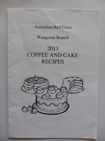 Warrnambool and District Historical Society Inc.
Document, Recipe Book Wangoom Red Cross, 2013
The Red Cross was formed in the 19th century as a service organization dedicated to helping those in need. The Australian Red Cross was established in 1914 and the Warrnambool Red Cross was established in the same year. Wangoom Red Cross was established at a later date. The recipe booklet was a means of funding the organization and utilizing the culinary knowledge and skills of the local women. Wangoom is a small settlement on the northern fringes of the city of Warrnambool. This booklet is of some interest as an example of the fund-raising methods used by the Wangoom Red Cross. It also shows the type of cakes and ingredients popular in 2013 (eg blueberries, muffins, mud cakes )These are three A4 pages folded to make 12 pages of printed recipes. The printing is black type on white paper with black and white sketches related to cookery. The pages are stapled.Front page: ‘Australian Red Cross, Wangoom Branch, 2013 Coffee and Cake Recipes’wangoom red cross, recipe books, warrnambool