Showing 2103 items
matching structures
-
 Melbourne Tram Museum
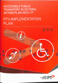
Document - Report, Public Transport Victoria (PTV), "Accessible Public Transport in Victoria Action Plan 2013-2017 - PTV Implementation Plan", 2013
Report - 36 pages, A4 card cover centre stapled titled "Accessible Public Transport in Victoria Action Plan 2013-2017 - PTV Implementation Plan", with a Forward by Mark Wild, CEO of PTV, detailing the structure, monitoring, reporting, customer service, engagement and access to facilities, including outcomes. Has a table of contents. See also Reg Item 5506 for 2006 to 2012 documentstrams, tramways, ptv, reports, transport, disability services, public transport -
 Bendigo Historical Society Inc.
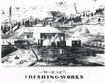
Document - LONG GULLY HISTORY GROUP COLLECTION: WM RAE CRUSHING WORKS
William Rae (1823-1887) was born into a farming family in Scotland and came to Australia in i852. After coming to the Bendigo area, he established a puddling machine in American Gully. He then bought a claim on the Victoria reef and was quite successful. Subsequently he bought a steam engine and three batteries to begin crushing quartz. This was such a boon that he moved to a more convenient location in Happy Valley, where he set up a crushing battery with 35 heads.Sketch of a crushing works. Printed underneath is: Wm. Rae's Crushing Works, Happy Valley, Bendigo. Written on the back is: Happy Valley Rd. South side below Wells St. Picture shows a crushing works building with a tall chimney and some smaller outbuildings. On the hill in the background are poppet legs, other mine structures and some trees. There are heaps of mullock and in the foreground are a number of people.bendigo, history, long gully history group, the long gully history group - wm rae crushing works, george ellis -
 Warrnambool and District Historical Society Inc.
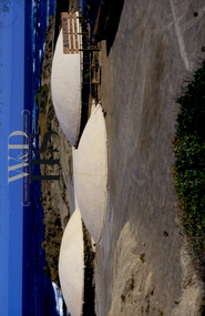
Photograph - Photographic slide Warrnambool Aquarium, 1970s
The Warrnambool aquarium was opened in 1971 and was mostly underground with three domes above ground level. It is situated near the Warrnambool breakwater and the main structure is still extant. It closed as an aquarium in 1990 and was then used by Deakin University as a research centre for a few years. The aquarium contained exhibits of marine life and shells. This slide is retained as a reminder of the Warrnambool aquarium, an important tourist attraction for over twenty years.This slide in a cardboard frame is a multi- coloured one of the Warranmbool aquarium showing the three domes and the coastline in the background. There is a wooden sign, a fence and the road in the foreground. AQUARIUM COOKED/ LIVE CRAYS SOUVENIRS BAIT MUSEUM KIOSK DOWNSTAIRS warrnambool, warrnambool aquarium -
 Melbourne Water
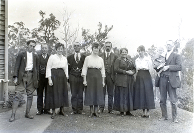
Transparency, Staff and Chauffeurs at the O'Shannassy Weir Quarters, 8th April, 1921
The O'Shannassy Weir was a small Weir created in 1911 and completed in 1913, and was the originating point of outflow into the Aqueduct. In 1928, it was replaced by the much larger O'Shannassy Reservoir. The Weir had water moving along the Aqueduct to the Surrey Hills Reservoir. Many structures at the Weir precinct have survived and remain in-situ.The O'shannassy Weir and Aqueduct contains a wide range of intact and diverse features. This demonstrates the way in which the Board constructed and managed the water supply that flowed through farmland and forest areas subject to timber milling. The caretakers residences that are located along the aqueduct were utilised by caretakers who were responsible for maintaining one of their four sections of the channel. This transparency is significant for its historic association to the establishment of the weir and to those who worked on the project, and at the quarters. weir, o'shannassy, aqueduct, reservoir, melbourne water, mmbw, staff -
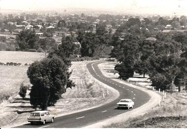 Hume City Civic Collection
Photograph, Early 1970s
In the early 1970s the eastern approach to Sunbury was changed. The stone bridge spanning the Jacksons Creek was replaced by a wider concrete structure and dangerous curves were taken out of the road. The area on the LHS of the photograph including the two arched stone bridge has been incorporated into a public picnic area.A black and white panoramic view of the eastern approach to Sunbury and the Sunbury township before the road was widened and straightened and the new bridge was built. There are two cars in the foreground. One is approaching the bridge and the other is leaving Sunbury.macedon street, macedon street road bridge, jacksons creek, sunbury township, george evans collection -
 Eltham District Historical Society Inc
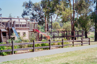
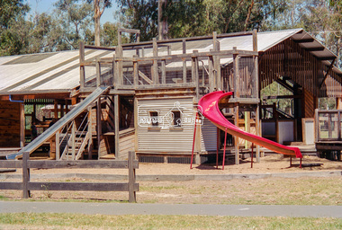
Negative - Photograph, Eltham North Adventure Playground, Wattletree Road, Eltham, 1998c
A community group project steered by Bambi McLean led to the construction of the Eltham North Adventure Playground which opened off Wattletree Road in 1995. The structure was mainly wooden and included an undercover element with slides and areas to climb. It was destroyed by fire in 2017. A new adventure playground was built in 2018.Roll of 35mm colour negative film, 8 strips and associated 10 x 15 cm colour printKodak Gold 100-5north eltham, north eltham adventure playground, wattletree road -
 Eltham District Historical Society Inc
Negative - Photograph, Eltham North Adventure Playground, Wattletree Road, Eltham, 1998c
A community group project steered by Bambi McLean led to the construction of the Eltham North Adventure Playground which opened off Wattletree Road in 1995. The structure was mainly wooden and included an undercover element with slides and areas to climb. It was destroyed by fire in 2017. A new adventure playground was built in 2018.Roll of 35mm colour negative film, 8 strips and associated 10 x 15 cm colour printKodak Gold 100-5north eltham, north eltham adventure playground, wattletree road -
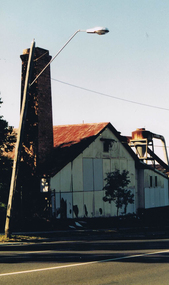 Greensborough Historical Society
Photograph - Digital image, Frank Solomon, Briar Hill Timber 4, 2012c
Briar Hill Timber was situated on Sherbourne Road Briar Hill and operated as a timber yard for many decades from he 1950s. This photo shows the chimney, the only part of the structure still remaining. These photographs were taken by Frank Solomon and depict the business just prior to its closure in 2014.Digital copy of colour photographbriar hill timber -
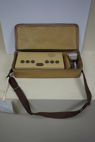 Vision Australia
Machine - Object, APH Pocket Braille
American Printing House pocket brailler consisting of a rectangle shaped structure made out of a brown coloured plastic with 7 keys and 3 buttons and a mustard coloured vinyl cover with attached handle and a power cord. Braille letters are achieved by punching the various keys. Serial number: Louisville 1354.Brown coloured plastic rectangular Brailler with covering vinyl bag with handle.braille equipment, assistive devices -
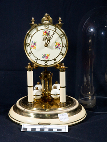 City of Moorabbin Historical Society (Operating the Box Cottage Museum)
Clocks, August Shatz , Domed Standard No Name 400 Day Clock Ivory Shelf Clock, c1949
August Shatz founded his clock making company in the mid-1850s in the Black Forest region of Triburg, Germany. It was registered in 1881 as Shatz & Wintermantel, and was re-structured in 1884 as Jahresuhrenfabrik A.G. They produced cuckoo clocks, barometers, and 400- day clocks. This clock was purchased and used by a resident of City of Moorabbin c1949This clock was purchased and used by a resident of City of Moorabbin c1949An August Schatz (Jahresuhernfabrik) standard size, 400 day clock c 1949 with a glass dome, ivory, enamel and brass decoration and a porcelain dial Circular engraved : AUG.SHATZ. & SOHN / GERMANY Square engraved : 10 JEWELS / UNADJUSTEDshatz, august , germany, clock makers, clocks, 400 day clocks, early settlers, city of moorabbin, bentleigh, cheltenham, -
 Bendigo Historical Society Inc.
Document - MINING REPORTS - GEOLOGICAL REPORT OF MAIN SECTION OF GOLDFIELD
Handwritten notes on a Geological report of main section in a length of 5 miles. Report mentions sandstones and slates, with occasional calcareous bands, which show a cyclic arrangement. Also mentioned are different zones of sediments, anticlines, structure of the field and references: Page 1028 Formation of Bendigo Quartz Reefs by F R Stilwell to 1032 and pages 160 to 163 'Ore deposits as Related to Structural Features - A H Newhouse.document, gold, mining reports, mining reports, geological report of main section of goldfield, the bendigo goldfields page 1015, formation of bendigo quartz reefs by f r stilwell page 1028 to 1032, ore deposits as related to structural features pages 160 to 163 a h newhouse -
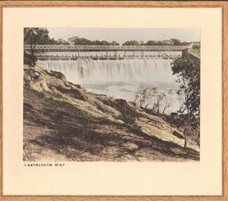 Bendigo Historical Society Inc.
Photograph - LAANECOORIE WEIR
Black and white (hand tinted) photograph of Weir structure at Laanecoorie. Figure on left of photo. Inscriptions: 'Laanecoorie Weir on reverse in black lead pencil. History: James Lerk 17.3.2000 'Laanecoorie Weir' built by Bendigo contractor. Valves by Roberts Foundry ' With note' photographs from Mrs Ella Bourke, 131 Barnard St, Bendigo Ph 43 8269. Photographs Frances (Frank) Thomas Bourke.Francis (Frank) Thomas Kennedyplace, water, laanecorrie weir -
 Nillumbik Shire Council
Sculpture: Anthony PRYOR (b.1951- d.1991 Melb, AUS), Paretaio, 1985
In the early 1970s, Arthur Boyd bought and restored a large, two-storey traditional farmhouse called Il Paretaio. Situated on the crest of a hill and surrounded by fields and olive groves, it is five kilometres from the village of Palaia in the province of Pisa, Tuscany. Boyd established this farmhouse as a residency programme, (which was later managed by the Australia Council). The residency program ended in 1990. Anthony Pryor undertook an Australia Council residency at Paretaio in 1984. This work is one in a series made during his time there. This work was entered into the Shire of Eltham Art Award in 1985.Pryor is an artist of national significance. This work is an example of his series of 'boxes' made principally for his own pleasure and often swapped with artists and other friends as soon as they were finished. The 'box' series was part inspired by Japanese techniques of wooden construction. Pryor first visited Japan in 1975 and was immediately drawn to Japanese methods of working with stone and wood. Many of these boxes are based upon the principles of the Japanese Zen Buddhist monk Sengai Gibon (1750-1838). This work relates to Sengai's famous hanging scroll Circle, Triangle and Square in which the circle can be read to stand for the cosmos, the square for the individual, and the triangle for aspiration. A heavy, box-like (cube) structure created from huon pine, with bronze, brass and stone elements. Within the cube is an eastern inspired, rear lattice wall in combination with bronze domestic fittings, and symbols (cube, pyramid and circle). Metal lightning, clouds and wooden rainbow hover over an asymmetrical bronze bed floating within the cube. A chair leans and a tilting ladder reaches towards the sky. Stamped into wood: lower right 'ANTHONY PRYOR PARETAIO'huon pine, pryor, brass, bronze, stone, cube, paretaio, italy, eastern, japan, sengai gibon, symbols, zen buddhism, sculpture, personal -
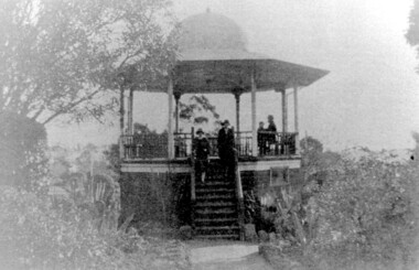 Surrey Hills Historical Society Collection
Photograph, John Gray Memorial Rotunda in Surrey gardens, Union Road, Surrey Hills, c 1925, c 1925
The rotunda was built in 1912 by Clarence Montgomery for the Surrey Hills Progress Association and the local community and dedicated to John Gray, "a highly respected and revered citizen". Surrey Hills Brass Band regularly gave concerts in the rotunda, provided music for regular 'loyal' celebrations and also for silent films held in the gardens. The rotunda was quite elevated off the ground due to the slope of the gardens and the bioscope was stored in the room underneath. This was later used as the infant welfare centre until the Progress Association built a dedicated facility for these purposes. The rotunda was demolished in 1972. Clarence Montgomery, carpenter, was living in Sunbury Crescent in 1914. By 1916 he had moved to 83 Croydon Road where he lived for the rest of his life. Clarence was born in 1869 in Taradale, son of John Montgomery and Jane Ford. He married Sarah Ann Ingram in Echuca in 1894. Their children were: 1. Annie (Mrs P Paynter) born Echuca in 1895 2. William Henry born Echuca in 1897 3. Christina Mary (Mrs F Meyers) born Echuca in 1898 4. Violet (Mrs G Ewing) born Echuca in 1902 5. Clarence George Ingram born Echuca in 1906 and died aged 7 months. Violet became a tailoress and Christina a dressmaker. William became a carpenter like his father. Sarah Ann Montgomery died at their home in June 1932 aged 62 years. Clarence died in August 1946 aged 77 years. They are buried in Box Hill Cemetery (P-EB-0020). John Gray was "actively associated with all movements for the benefit of neighbours and fellow citizens". [Quote from the official tribute on his death in 1909.] He was very active in the Surrey Hills Progress Association in the early 1900's. The rotunda built in the Surrey Gardens by the Progress Association in 1912 was dedicated to him. John Gray was born in 1861 in Eldorado. He died on 7 December 1909 in Surrey Hills and is buried in Box Hill Cemetery (M0472). He married Emma Beckett in 1888 at 'Guildford Villa' in Essex Road, the Beckett home. They are listed in both the 1903 and 1906 electoral rolls in Arundel Crescent; his occupation is given as bootmaker. The Alan Holt property register identifies this as 24 Arundel Crescent, known as 'Tumberumba'. John and Emma had a large family: (Gunner) John Robert Gray (1888, Surrey Hills - 21 June 1917, France) Benjamin Walter Gray (1890, Surrey Hills - 1949, Heidelberg) Herbert Harry Gray (1892, Surrey Hills - 1959, Queensland) William Beckett Gray (1897, Surrey Hills - 1899, Surrey Hills) Norman Douglas Gray (1901, Surrey Hills - 1947, Sydney) Evelyn Lizzie Gray (1906, Surrey Hills - 1983) Evelyn married Reginald Roberts and donated a number of photos to the collection. The donor Violet Ewing (nee Montgomery) was Clarence's daughter. She married George Isaac Henry Ewing (blacksmith) in 1934. They inherited the family home at 83 Croydon Road. Although constructed 5 years after their opening, this rotunda was a central feature of the Surrey Gardens which was planted to a design adapted from one suggested by the renowned landscape gardener and botanist William Robert Guilfoyle (1840-1912). Rotundas were a key feature of many late nineteenth and early twentieth century public parks. This particular rotunda was notable for the Chinoiserie influence reflected in its roof. Surrey Gardens are now regarded as one of the City of Boroondara's heritage gardens and this image is significant as evidence of the design of the rotunda which is no longer extant. It is also significant as evidence of the extent of the role of the Surrey Hills Progress Association in the provision of public facilities. A black and white photo of an octagonal rotunda situated within Surrey Gardens taken from the perspective of the main entrance. It is a largely wooden structure with a domed chinoiserie-style roof. The rotunda is enclosed by established gardens. There are 4 people in the photo, with 2 women standing on the steps at the rotunda's entrance. A man and a young person are seated within the rotunda. It has 8 support pillars, which are open with balustrades to 7 sides.rotundas, surrey gardens, union road, surrey hills progress association, surrey hills brass band, parks and reserves, 1925, john gray, clarence montgomery, box hill cemetery, cinema, john gray memorial rotunda, bandstands -
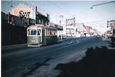 Melbourne Tram Museum
Photograph - Colour Print, Keith Stodden, 1959
Colour print of X1 class tram No. 677 eastbound in Glenhuntly road, just prior to the Elsternwick station level crossing. Shows the railway overhead structures, shops on the north side of the road with signs for Turf tobacco, The Sun, The Age, the Rex?? and an advertisement board for Hoyts. Photo shows the crossover just before the level crossing. From a slide by Keith Stodden. Printed on Fujichrome Crystal Archive paper.On rear in black ink "Elsternwick 1959 from slide by Keith M. Stodden"trams, tramways, elsternwick, glenhuntly rd, x1 class, level crossings, tram 677 -
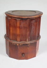 Bendigo Historical Society Inc.
Domestic object - Commode
A wooden commode, a cylindrical shape in two sections. The top section is possibly mass produced, it's 40 centimetres diameter and 27centimetres high, it has a hinged circular lid with a hinged toilet seat under it. Below is a space for a container. A hand made section has been added underneath to raze it 20 centimetres and includes a draw. An insert has fitted into the original structure to hold a smaller pot.commode, chamber pot -
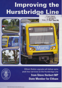 Eltham District Historical Society Inc
Folder, Hurstbridge Line Upgrade, 2010
Correspondence and information from the State Government about the Hurstbridge Line upgrade 2010. Also includes newspaper articles, Nillumbik Shire Council minutes report, map and contextual information regarding the Eltham Major Activity Centre structure Plan 2009. The main area of concern was the plan to reconfigue the Eltham stabling yard.23 documents, 62 pages of news clippings, photocopies and colour political fliersHG Folders 108 and 115harry gilham collection, railway line construction, hurstbridge line, hurstbridge railway line, eltham railway station, eltham station carpark, train stabling yard -
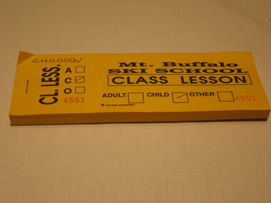 Parks Victoria - Mount Buffalo Chalet
Tickets
"The collection of ephemera builds on the Chalet's holding of archival material with a range of interesting, original items. Dinner menus., stationery., luggage labels, tickets, dockets and plans help to interpret the structured routine and social conventions of the Chalet that held sway for so many years." (pg 127 MBCC) Probably printed by Rayner QuickprintListed in Draft inventory of significant collection items. Appendix A.3. Ephemera. (pg 169). The tickets are made of yellow paper; on the front page it says "Mt. Buffalo Ski School Class Lesson"; there are 3 empty squares in order to say if it is for an adult, child or other; the information on the right side of the ticket is for the customer, the left part of the ticket is for the seller with just the information adult, child or other; on the right side there is a ticket number, there are 449 tickets in this book;On the reverse of the ticket there is a "disclaimer of liability"; signed by Mt. Buffalo Ski School, Cresta, Mt. Buffalo -
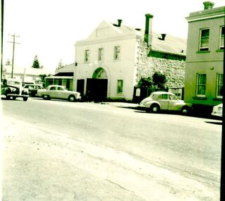 Port Fairy Historical Society Museum and Archives
Photograph
Drill Hall, Bank Street, Port Fairy. This two-storied building was constructed in 1874 as livery stables and was later used for the garrison from c.1885. The structure is symmetrically arranged about a large arched opening and features include the plinth, quions and the parapet. Reconditioned c.2000 when the interior was renovated for functionsBlack and white photograph of the drill hall a two storied rendered building with double doors opening into the streetdefence, hall, drill hall, bank street -
 Federation University Historical Collection
Book, Memoirs of the Geological Survey of Victoria No 14 The Ballarat Goldfields, 1923, 1923
William Baragwanath was educated at the Ballarat School of Mines, obtaining a Geology Certificate in 1911. After further study he went on the become Secretary for Mines, and Chief Mining Surveyor. Baragwanath was a Councillor of the Ballarat School of Mine from 1916 to 1950.Pink covered foolscap book of 257 pages and 32 maps and plans by William Baragwanath. Contents include topography, physiography, historical, geology, basalt, faults, dykes, minerals leads, alluvial mines, nuggets, structure of Ballarat West goldfields, structure of Ballarat East gold-field, quartz formation, indicators, defunct mines, existing mines, table of deepest shafts. Images include: section of the Ballarat Gold-Field, Dead HOrse Flat, lakes formed by Basalt Flows, Gong Gong Creek, Frenchman's Lead, Ballarat West Mines, LEases and positions of shafts (1857), puddling, White Horse Lead, Woah Hawp Canton, Ballarat Township mines, Sebastopol, syncline, Victoria United Line, First Chance Mine, Llanberris No 1 Mine, Saddle Reef, New Normanby Mine, Woah Hawp Canton Mine, South Star Mine, Sebastopol Plateau, south Woah Hawp Mine, Woah No. 2 Minegeology, geological survey no 14, ballarat, baragwanath, william baragwanath -
Glen Eira Historical Society
Document - Murrumbeena State School No. 3449
This file contains a photocopy of entry for Murrumbeena Primary School from a Caulfield Conservation Study by Andrew Ward, March 1995, noted in study are site address, a description of the building’s structure, history, references and statement of significance. Also in this file is a typed history of Murrumbeena Primary School with added hand – written notations. There is not author and it is undated.murrumbeena primary school, rosstown state school, multi – purpose hall, murrumbeena state school, gippsland railway, enrolment, hobart road murrumbeena, presbyterian church hall, out of school hours., statement of significnace, carnegie state school, east kew primary school, andrew ward., victorian public works department, staff and administration, maintenance. -
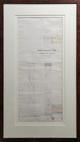 Federation University Historical Collection
Drawing - Architectural Plan, Ballarat School of Mines Gauge Tower Architectural Plan by Henry Richards Caselli, 04/11/1880
The Ballarat School of Mines was the first of its type in Australia. The Albert Street frontage was the 'working end' of the campus with the mining laboratory, gauge tower and caretakers cottage. All the structures in the foreground have been demolished to make way for the Flecknoe Building and the M.B. John Building. The gauge tower is also depicted in the 1881 Annual Report.Original double mounted and framed architectural plan for the Ballarat School of Mines Gauge Tower. The plan includes sections and elecation. Some areas have been coloured, and the drawing is at a scale of four feet to one inch. Verso in ink "Gauge Tower School of Mines" Signed left "H.R. Caselli architect 4.11.80henry caselli, henry richards caselli, architectural plan, ballarat school of mines, gauge tower, buildings, architect -
Unions Ballarat
Nomination forms of members and lists of members, 1912-13. Political Labor Council of Victoria, Ballarat Branch, 1912-13
Constitution of the Political Labor Council of Victoria can be found at http://tinyurl.com/politicallabourcouncilvic. It has platforms at federal, state and municipal levels. The state platform includes land policy, financial policy including restriction of public borrowing, reform of parliamentary structure, industrial regulation, free education, support for technical education and adequate pensions.Comprises part of the history of Ballarat's participation in the Political Labor Council of Victoria.Paperpolitical labor council of victoria, btlc, ballarat trades and labour council, ballarat trades hall, public borrowing, constitution, reform, parliament, education -
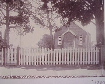 City of Kingston
Photograph - Black and white, Methodist Church Cheltenham, 1909
The first Methodist church built in Cheltenham was a wooden structure which burnt down in 1893. While the exact cause of the fire was never ascertained, it was believed that a spark from a passing train ignited dried leaves in the eaves. The original church was replaced by a brick building, with the foundation stone laid in 1894. This image shows the replacement building.Black and white photograph of the brick Methodist Church in Cheltenham with a white picket fence and gate at the front. -
 Melbourne Tram Museum
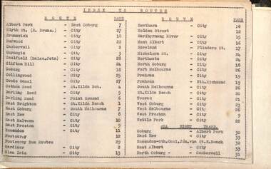
Administrative record - Tram fare route diagrams or maps, Melbourne & Metropolitan Tramways Board (MMTB), 1930s
The route maps give for each tram, including cable trams, and bus routes, a map of the fare structure, sections, all-night routes, details of transfers and tickets such as combined tickets. Not dated as such but sheet 1 has a note regarding the East Brighton - St Kilda route that it was out of date from 16/10/1938.Yields information about the MMTB fare structure for tram, and bus routes during the 1930s.Album brown card heavy card coves, secured with two interscrews containing a type index, 33 cartridge paper sheets with ink drawings and six loose sheets. Hand drawn in black, red and green ink.mmtb, tramways, fares, maps, routes, buses, cable trams -
 Victoria Police Museum
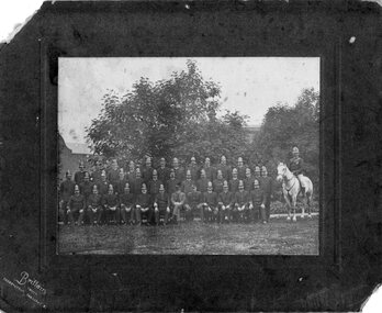
Photograph (Victoria Police), Police Officers group photo, 1920s
Black and white photograph mounted on grey frame. 16 Police Officers mounted on Horses. Black and white (sepia) photograph mounted on brown frame. 38 police officers on photo. 1 is mounted on horse on the right of frame; 2 pehraps superior level officers like sit on the middle and 35 other compose on 3 row structure. They are in full uniform (no insigmnia) with helmets - most of them have fair mustahces.Handwritten: EP 1victoria police museum, police officers, police academy, police force, victorian police association, police council -
 Bendigo Historical Society Inc.
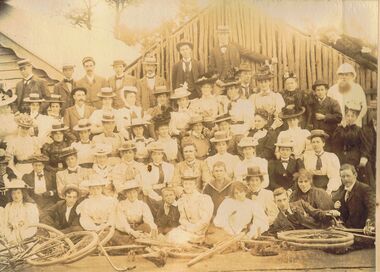
Photograph - QUEENS' CYCLING CLUB, 1897
Sepia image mounted on board: image shows large group of men, women and children, standing and seated in front of bicycles. Most are wearing boater style hats, some women shirts and ties. Group is in front of weatherboard building on LH side, and shed like structure, made of undressed small logs, on RH side. Small boy reclining on roof of shed. Written on bottom of image: 'Queens' Cycling Club, 1897'bendigo, clubs, queens' cycling club, bendigo, cycling, bicycles, queens' cycling club -
University of Melbourne, Burnley Campus Archives
Plan - Coloured plan, Plan of Burnley Gardens, 1929?
Layout of gardens, farm buildings, orchard, etc. overlaid on part of Lands Department map. See paper catalogue for full descriptionPart of larger plan (Lands Department Parish Plan). Partly hand-drawn. Area bounded by Yarra River, Swan St, Glen Iris railway line. Shows Burnley Gardens layout, handwritten amendments and explanation of existing and proposed structures including: Pavilion, sketch of unbuilt Administrative Building, poultry yard, contours of old orchard, sketch for Plant Research Institute, ditch, silo, milking shed, laying pens. See aboveburnley gardens, pavilion, burnley school of horticulture, farm buildings, poultry -
 Robin Boyd Foundation
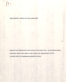
Document - Manuscript, Robin Boyd, The Shanty Town at Tullamarine, 1971
Discusses the reasons for Sydney's and Melbourne's new airports. Discusses the transformation from picturesque landscape to a growth of unordered supplementary structures surrounding airports (motels, sheds, storage rooms, petrol stations, shopping mall). Boyd predicts this "shanty town" image will only get worse, and critiques the image of Australia first presented to international visitors.Original manuscript of an article published in "The Sunday Australian", 27.06.1971Typewritten (c copy), quarto, 8 pagesNumbered in 13 paragraphstullamarine airport, international airport, melbourne's shanty town, robin boyd, manuscript -
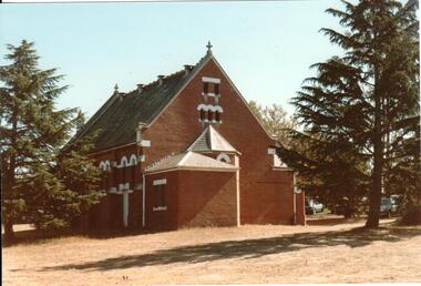 Hume City Civic Collection
Photograph, c 1990s
St. Andrew's Uniting Church, formerly the Presbyterian church includes two different church buildings as well as a new addition built at the rear of the 1904 red brick building. A small weather board structure was used as a church until the Romanesque brick building opened in 1904. The new church extensions were completed on 14 December, 1986.A rear view of St. Andrew's Uniting Church before the extensions were built. The photograph shows the small apse and porch as well as the surrounding conifers which were growing in the church grounds.churches, religion, tompkins, f. b., h. w., goyen, w. rev., st. andrew's uniting church, presbyterian church, george evans collection